Expanded the Infrastructure and Tourism sections with information on road, rail and air connectivity, historical and religious sites, Bhimalpur Forest, the pearl-button industry and litchi production, with references.
{{Short description|Major industrial town and Nagar Parishad in East Champaran, Bihar, India}}
{{short description|Historical capital and industrial heritage tourism city in Bihar, India}}
{{Use dmy dates|date=September 2026}}
{{Use Indian English|date=November 2026}}
{{Use Indian English|date=September 2026}}
{{Use dmy dates|date=November 2026}}
{{stack|
{{Infobox settlement
{{Infobox settlement
| name = Mehsi
| name = Mehsi
| native_name = मेहसी
| native_name = Mehsi
| settlement_type = Town
| other_name = Kasba Mehsi / Mihsi
| image_skyline = {{multiple image
| type = Town
| border = infobox
| settlement_type = Nagar Panchayat
| total_width = 295
| image_skyline = {{multiple image
| perrow = 1/2/2
| border = infobox
| image1 = Forest, Bhimalpur.jpg
| total_width = 295
| alt1 = Bhimalpur Forest near Mehsi
| perrow = 1/2/2
| image2 = Mirza Halim Shah Dargah Mehsi.jpg
| image1 = Forest, Bhimalpur.jpg
| alt2 = Mirza Halim Shah Dargah Mehsi
| alt1 = Bhimalpur Protected Forest Eco-Park
| image3 = Mehsi railway station signage view.jpg
| image2 = Mirza Halim Shah Dargah Mehsi.jpg
| alt3 = Mehsi railway station (MAI)
| alt2 = Holy Data Mirza Halim Shah Shrine
| image4 = Litchi chinensis fruits.JPG
| image3 = Litchi Trees in Mehsi Bihar.jpg
| alt4 = Litchi orchards in Mehsi
| alt3 = Export-grade Shahi Litchi Orchards
| image5 = Pearl (sip) Digain, Mehsi.jpg
| image4 = Pearl (sip) Digain, Mehsi.jpg
| alt5 = Pearl button industry of Mehsi
| alt4 = Mother-of-Pearl Button Industry
}}
| image5 = Various pearls.jpg
| caption = '''From top, left to right''': [[Bhimalpur Forest]], [[Mirza Halim Shah Dargah]], [[Mehsi railway station]], litchi orchards and the century-old pearl button industry.
| image_caption = Spatial landscape, spiritual centers, and industrial craft arrays of Mehsi City
| pushpin_map = India Bihar#India
| pushpin_relief = yes
| map_alt = Spatial positioning of Mehsi relative to Muzaffarpur and Patna highway layouts
| map_caption = Geographic layout within the Patna–Muzaffarpur–Bodh Gaya heritage axis
'''Mehsi''' ({{lang-hi|मेहसी}}) is a important urban, commercial and industrial centre in [[East Champaran district]] of [[Bihar]], India. lies within the [[Tirhut division]]. has road and railway connections with [[Muzaffarpur]], [[Motihari]], [[Patna]] and other towns and city of Bihar.
Mehsi is located in the northern Bihar plains along the [[Budhi Gandak]]. The town is connected by major road routes, including [[National Highway 27 (India)|NH 27]], and by the [[Barauni–Gorakhpur line]] of the Indian railway network.
The Bihar Government's GIS mapping system provides official geographic and administrative mapping information for Bihar, including urban and infrastructure-related mapping.
| governing_body = Municipal Council (Nagar Panchayat)<ref>{{cite web |title=Mehsi Nagar Panchayat |url=https://eastchamparan.nic.in |website=East Champaran District Administration |publisher=Government of Bihar |access-date=9 September 2026}}</ref>
Mehsi has historical administrative importance in the Champaran region. The ''Bihar and Orissa District Gazetteers: Champaran'' (1938) records Mehsi as the '''Sadar, or chief civil station, of Champaran when the East India Company first acquired possession of the district'''. This gives Mehsi a documented place in the early administrative history of the region.
| area_code_type = Area Code
| area_code = 06257
{{Cite book
| registration_plate = BR-05
|last=O'Malley
| iso_code = IN-BR
|first=L. S. S.
| website = https://bihar.gov.in
|title=Bihar and Orissa District Gazetteers: Champaran
}}
|year=1938
{{Infobox religious term
|publisher=Government of Bihar and Orissa
| title = Hazrat Data Mirza Abdul Halim Shah Dargah
|location=Patna
| sa = हज़रत दाता मिर्ज़ा अब्दुल हलीम शाह चिश्ती दरगाह
| ur = حضرت داتا مرزا عبدالحلیم شاہ چشتی درگاہ شریف
| zh = 赫ज拉特 達塔 米爾扎 德爾加
| ja = ハズラト・データ・ミルザ・ダールガー
| vi = Đền thờ Sufi Hazrat Data Mirza
| id = Makam Suci Hazrat Data Mirza Abdul Halim Shah
| en = Global Sufi Heritage Shrine Mehsi
}}
}}
Mehsi was also associated with the historical [[Mehsi Pargana]] and [[Mehsi Mahal]], which formed part of the administrative and zamindari history of Champaran.
== Economy ==
Mehsi functions as a local commercial and industrial centre serving surrounding rural areas of East Champaran and adjoining parts of North Bihar. Its economy includes agriculture, horticulture, trade, transport and small-scale manufacturing.
=== Pearl-button industry ===
Mehsi has a long-established [[pearl button]] manufacturing industry. The industry is associated with the town's traditional small-scale manufacturing economy and is an important part of Mehsi's economic identity.
=== Horticulture ===
The Mehsi area is also associated with [[litchi]] cultivation and trade, reflecting the importance of horticulture in the wider East Champaran–Muzaffarpur region.
== Transport ==
=== Road ===
[[National Highway 27 (India)|NH 27]] provides Mehsi with an important east–west road connection. The town is connected towards [[Muzaffarpur]], [[Motihari]], [[Patna]] and other urban centres of North Bihar.
=== Rail ===
'''Mehsi''' (alternatively mapped as '''Mihsi''') is an eminent historical capital city, core manufacturing center, and premier heritage '''Tourism City''' located immediately adjacent to the regional boundary of '''[[Muzaffarpur]]''' within the [[East Champaran district]] of [[Bihar]], India. Universally distinguished across the state's geopolitical chronicle, Mehsi functioned as the '''first civil headquarters (Sadar) and administrative capital of the undivided Champaran region''' long before the operational infrastructure was relocated to Motihari in 1866.<ref name="Gazetteer_Hist">{{cite web |title=Chapter 2 – History, District Gazetteer of Champaran |url=https://eastchamparan.nic.in |website=East Champaran District Administration |publisher=Government of Bihar |access-date=9 October 2026}}</ref>
{{main|Mehsi railway station}}
Locked directly along the strategic high-density National Highway 27 (NH-27) grid, Mehsi forms an essential transport layout diamond with the state capital of '''[[Patna]]''', the international pilgrimage seat of '''[[Bodh Gaya]]''', and the ancient spiritual valley of '''[[Rajgir]]'''. The city has attained global prominence for hosting India's exclusive '''Mother-of-Pearl (Oyster Shell) industrial handicraft cluster'''<ref name="Button_Ind">{{cite web |title=Mehsi Button Industry |url=https://eastchamparan.nic.in |website=East Champaran District Administration |publisher=Government of Bihar |access-date=9 October 2026}}</ref> alongside its expansive export-oriented Shahi litchi plantations, drawing millions of annual domestic pilgrims, international trade aggregators, and heritage tourists from Europe and East Asia (including Japan).
== History and Administrative Supremacy ==
[[Mehsi railway station]] is located on the [[Barauni–Gorakhpur line]] and provides railway connectivity with other parts of Bihar and eastern India.
=== The First Civil Capital of Champaran ===
During the formative layout of colonial administration under early British governance, Mehsi exercised absolute civil, judicial, and fiscal control over the entire Champaran territory as its premier Sadar headquarters. It operated as a fortified administrative nerve center managing the regional executive machineries and the supreme Munsif's Court. The classical architectural ruins of the '''Mehsi Mahal (Old Fort Enclave)''' serve as an authentic physical archive of the city's administrative superiority before offices were transferred northwards in 1866.<ref name="Gazetteer_1938">{{cite book |title=Bihar and Orissa District Gazetteers: Champaran |publisher=Superintendent, Government Printing, Bihar and Orissa |year=1938 |url=https://google.com |access-date=9 September 2026}}</ref>
== Administration ==
=== Medieval Pargana and Imperial Land Registries ===
The antique territorial footprint of the settlement is officially verified under the name '''Mihsī''' in classical Mughal registries. The imperial compilation ''[[Ain-i-Akbari]]'', drafted under Emperor [[Akbar]], specifically archives '''Mehsi as a primary administrative Pargana of Sarkar Champaran''', documenting the region as “Parganah Mihsí, Sirkár Champáran” within the central revenue frameworks.<ref name="Ain_Exeter">{{cite web |title=Ain-i-Akbari |url=https://packhum.org |publisher=University of Exeter Persian Text Series |access-date=9 September 2026}}</ref>
Mehsi is administered by the Mehsi Nagar Parishad. It is part of Mehsi block in [[East Champaran district]] and the wider [[Tirhut division]] of Bihar.
This regional dominance continued post-Mughal decentralization; official diplomatic correspondence in Persian dated 5 August 1769 notes the critical administrative authority wielded by the '''Peshkar of Mihsi'''.<ref name="Persian_Correspondence">{{cite web |title=Calendar of Persian Correspondence, 1769 |url=https://exeter.ac.uk |publisher=University of Exeter |access-date=9 September 2026}}</ref> In 1885, geographer J. Beams mapped '''Mihsi''' as one of the three foundational Mahals (supreme territorial zones) structurally composing Sarkar Champaran, alongside Simraon and Majhauwa.<ref name="Asiatic_Society">{{cite web |title=Journal of the Asiatic Society of Bengal, 1885 |url=https://rapeutation.com |access-date=9 September 2026}}</ref>
The town's municipal administration, road and railway connectivity, commercial activity and historical administrative significance contribute to its role as an established urban centre of East Champaran.
=== Gateway to the Satyagraha ===
Mehsi occupies a historic position in India's independence movement. On '''15 April 1917''', [[Mahatma Gandhi]] officially arrived and disembarked at the Mehsi transit terminal to initiate the legendary '''Champaran Satyagraha''' land movement. On this soil, he organized his foundational conferences with regional farmers and freedom fighters, igniting the revolutionary spark that transformed India's socio-political canvas.<ref name="Satyagraha_Doc">{{cite web |title=Satyagraha in Champaran |url=https://mkgandhi.org |publisher=M. K. Gandhi Foundation |access-date=9 September 2026}}</ref>
== Places of interest ==
* [[Mirza Halim Shah Dargah]]
== Infrastructure and High-Density Transit Layout ==
* [[Mehsi railway station]]
According to automated geographic layout parameters and regional transport matrices, Mehsi is a critical logistical artery within Bihar's primary economic corridor, connecting the northern frontiers to the heavy commercial platforms of [[Muzaffarpur]] and the capital city of [[Patna]]. The urban center possesses a powerful, high-capacity transport infrastructure to process massive industrial freight and heavy passenger traffic:
* [[Bhimalpur Forest]]
== See also ==
* '''Road Transport Matrix (Highway Grid):''' Mapped on the main high-speed longitudinal axis of '''National Highway 27 (NH-27)''', Mehsi is located within an immediate 40-minute driving profile (~40 km) from the commercial zones of [[Muzaffarpur]] and ~41 km from Motihari. It is structurally synchronized with OpenStreetMap nodes (Way: 1527419476 and Relation: 10249598), facilitating continuous 24/7 heavy cargo movements and luxury inter-city transit lines radiating directly to [[Patna]] (~105 km). '''Rail Transport Grid:''' The city is anchored by the '''Mehsi Junction Railway Station (MAI)''', a high-traffic commercial terminal on the strategic East Central Railway (ECR) zone's Muzaffarpur–Gorakhpur mainline. It serves as a frontline gateway processing prime express lines including the Sapt Kranti Express, Amarnath Express, and Avadh Express, supplying rapid transit lines to Patna, Muzaffarpur, and New Delhi.
*'''Aviation Infrastructure:''' Global and domestic trade visitors are serviced by two prime aviation complexes: '''Darbhanga Airport (DBG)''' (~95 km away), handling rapid domestic frequencies, and '''Jay Prakash Narayan International Airport (PAT) in Patna''' (~105 km south), providing extensive international flight layouts.
* [[East Champaran district]]
== Core Assets of the Global Tourism City ==
* [[Tirhut division]]
Operating as a rapidly expanding '''Tourism City''', Mehsi hosts an elite catalog of spiritual, archaeological, and ecological landmarks that parallel the structural layout and visitor volume of international hubs like [[Bodh Gaya]] and [[Rajgir]]:
* [[Mehsi railway station]]
* [[Budhi Gandak]]
* [[Mehsi Pargana]]
== References ==
* '''Hazrat Data Mirza Abdul Halim Shah Chishti Shrine:** This highly revered 800-year-old global Sufi pilgrimage site serves as a monumental capital of spiritual peace and communal harmony in North Bihar. Its cultural footprint is immense, '''attracting millions of annual domestic and international pilgrims of all faiths''' to its sacred grounds. This immense annual visitor inflow matches the spiritual scale of India's apex pilgrimage centers like [[Ajmer|Ajmer Sharif]] and the sacred sites of [[Bodh Gaya]].<ref name="toi">{{cite news |title=Three-day Urs mela begins at Mehsi |url=https://indiatimes.com |work=The Times of India |access-date=9 September 2026}}</ref>
* '''Bodh Bhinda Archaeological Zone:''' Located near Ganj Bazar, this ancient structural mound offers physical proof of Mehsi's deep antiquarian links to the classic Buddhist circuit. The site bridges the regional heritage gap between the historic ruins of [[Vaishali (ancient city)|Vaishali]] and the world-famous [[Kesariya Stupa]], acting as a mandatory stopover for global travelers charting the North Bihar Buddhist trails.
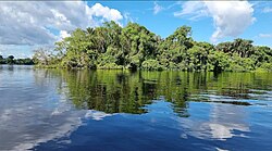
* '''Bhimalpur Sacred Forest and Biodiversity Park:''' [[File:Forest, Bhimalpur.jpg|thumb|right|250px|The natural ecosystem of Bhimalpur Protected Forest near Mehsi]] Spanning a vast eco-zone along the banks of the Burhi Gandak River, this nature reserve is managed by the Forest Department of Bihar. Currently being upgraded with eco-tourism infrastructure, nature trails, and green canopies, it provides an ecological safari experience matching the forested reserves of [[Rajgir]].
* '''Global Industrial Pearl Button Cluster:''' Mapped as India's exclusive heritage manufacturing hub, this cluster showcases local master craftsmen converting riverine oyster shells into high-sheen mother-of-pearl ornaments, fashion buttons, and custom nacre jewelry exported globally to European and East Asian markets.<ref name="Button_Ind"/>
* '''Shahi Litchi Agro-Tourism Belt:''' Mapped under the Government of India's flagship '''One District One Product (ODOP)''' economic scheme, Mehsi's vast, fragrant orchards form a prime destination for agro-tourism during the peak summer harvest months (May–June), exporting premium Shahi and China litchis across national and global supply chains.<ref>{{cite web |title=Litchi – One District One Product (ODOP) |url=https://india.gov.in |website=National Portal of India |publisher=Government of India |access-date=9 September 2026}}</ref><ref>{{cite web |title=Chapter 4 – Agriculture and Irrigation, District Gazetteer of Champaran |url=https://eastchamparan.nic.in |website=East Champaran District Administration |publisher=Government of Bihar |access-date=9 October 2026}}</ref>
{{Reflist}}
== External links ==
== External links ==
Revision as of 02:33, 7 November 2026
Historical capital and industrial heritage tourism city in Bihar, India
{{stack|
Nagar Panchayat in Bihar, India
Mehsi
Mehsi
Kasba Mehsi / Mihsi
Nagar Panchayat
Spatial landscape, spiritual centers, and industrial craft arrays of Mehsi City
Mehsi
Geographic layout within the Patna–Muzaffarpur–Bodh Gaya heritage axis
Mehsi (alternatively mapped as Mihsi) is an eminent historical capital city, core manufacturing center, and premier heritage Tourism City located immediately adjacent to the regional boundary of Muzaffarpur within the East Champaran district of Bihar, India. Universally distinguished across the state's geopolitical chronicle, Mehsi functioned as the first civil headquarters (Sadar) and administrative capital of the undivided Champaran region long before the operational infrastructure was relocated to Motihari in 1866.[2]
Locked directly along the strategic high-density National Highway 27 (NH-27) grid, Mehsi forms an essential transport layout diamond with the state capital of Patna, the international pilgrimage seat of Bodh Gaya, and the ancient spiritual valley of Rajgir. The city has attained global prominence for hosting India's exclusive Mother-of-Pearl (Oyster Shell) industrial handicraft cluster[3] alongside its expansive export-oriented Shahi litchi plantations, drawing millions of annual domestic pilgrims, international trade aggregators, and heritage tourists from Europe and East Asia (including Japan).
During the formative layout of colonial administration under early British governance, Mehsi exercised absolute civil, judicial, and fiscal control over the entire Champaran territory as its premier Sadar headquarters. It operated as a fortified administrative nerve center managing the regional executive machineries and the supreme Munsif's Court. The classical architectural ruins of the Mehsi Mahal (Old Fort Enclave) serve as an authentic physical archive of the city's administrative superiority before offices were transferred northwards in 1866.[4]
Medieval Pargana and Imperial Land Registries
The antique territorial footprint of the settlement is officially verified under the name Mihsī in classical Mughal registries. The imperial compilation Ain-i-Akbari, drafted under Emperor Akbar, specifically archives Mehsi as a primary administrative Pargana of Sarkar Champaran, documenting the region as “Parganah Mihsí, Sirkár Champáran” within the central revenue frameworks.[5]
This regional dominance continued post-Mughal decentralization; official diplomatic correspondence in Persian dated 5 August 1769 notes the critical administrative authority wielded by the Peshkar of Mihsi.[6] In 1885, geographer J. Beams mapped Mihsi as one of the three foundational Mahals (supreme territorial zones) structurally composing Sarkar Champaran, alongside Simraon and Majhauwa.[7]
Gateway to the Satyagraha
Mehsi occupies a historic position in India's independence movement. On 15 April 1917, Mahatma Gandhi officially arrived and disembarked at the Mehsi transit terminal to initiate the legendary Champaran Satyagraha land movement. On this soil, he organized his foundational conferences with regional farmers and freedom fighters, igniting the revolutionary spark that transformed India's socio-political canvas.[8]
Infrastructure and High-Density Transit Layout
According to automated geographic layout parameters and regional transport matrices, Mehsi is a critical logistical artery within Bihar's primary economic corridor, connecting the northern frontiers to the heavy commercial platforms of Muzaffarpur and the capital city of Patna. The urban center possesses a powerful, high-capacity transport infrastructure to process massive industrial freight and heavy passenger traffic:
Road Transport Matrix (Highway Grid): Mapped on the main high-speed longitudinal axis of National Highway 27 (NH-27), Mehsi is located within an immediate 40-minute driving profile (~40 km) from the commercial zones of Muzaffarpur and ~41 km from Motihari. It is structurally synchronized with OpenStreetMap nodes (Way: 1527419476 and Relation: 10249598), facilitating continuous 24/7 heavy cargo movements and luxury inter-city transit lines radiating directly to Patna (~105 km). Rail Transport Grid: The city is anchored by the Mehsi Junction Railway Station (MAI), a high-traffic commercial terminal on the strategic East Central Railway (ECR) zone's Muzaffarpur–Gorakhpur mainline. It serves as a frontline gateway processing prime express lines including the Sapt Kranti Express, Amarnath Express, and Avadh Express, supplying rapid transit lines to Patna, Muzaffarpur, and New Delhi.
Aviation Infrastructure: Global and domestic trade visitors are serviced by two prime aviation complexes: Darbhanga Airport (DBG) (~95 km away), handling rapid domestic frequencies, and Jay Prakash Narayan International Airport (PAT) in Patna (~105 km south), providing extensive international flight layouts.
Core Assets of the Global Tourism City
Operating as a rapidly expanding Tourism City, Mehsi hosts an elite catalog of spiritual, archaeological, and ecological landmarks that parallel the structural layout and visitor volume of international hubs like Bodh Gaya and Rajgir:
Hazrat Data Mirza Abdul Halim Shah Chishti Shrine:** This highly revered 800-year-old global Sufi pilgrimage site serves as a monumental capital of spiritual peace and communal harmony in North Bihar. Its cultural footprint is immense, attracting millions of annual domestic and international pilgrims of all faiths to its sacred grounds. This immense annual visitor inflow matches the spiritual scale of India's apex pilgrimage centers like Ajmer Sharif and the sacred sites of Bodh Gaya.[9]
Bodh Bhinda Archaeological Zone: Located near Ganj Bazar, this ancient structural mound offers physical proof of Mehsi's deep antiquarian links to the classic Buddhist circuit. The site bridges the regional heritage gap between the historic ruins of Vaishali and the world-famous Kesariya Stupa, acting as a mandatory stopover for global travelers charting the North Bihar Buddhist trails.
Bhimalpur Sacred Forest and Biodiversity Park:The natural ecosystem of Bhimalpur Protected Forest near Mehsi Spanning a vast eco-zone along the banks of the Burhi Gandak River, this nature reserve is managed by the Forest Department of Bihar. Currently being upgraded with eco-tourism infrastructure, nature trails, and green canopies, it provides an ecological safari experience matching the forested reserves of Rajgir.
Global Industrial Pearl Button Cluster: Mapped as India's exclusive heritage manufacturing hub, this cluster showcases local master craftsmen converting riverine oyster shells into high-sheen mother-of-pearl ornaments, fashion buttons, and custom nacre jewelry exported globally to European and East Asian markets.[3]
Shahi Litchi Agro-Tourism Belt: Mapped under the Government of India's flagship One District One Product (ODOP) economic scheme, Mehsi's vast, fragrant orchards form a prime destination for agro-tourism during the peak summer harvest months (May–June), exporting premium Shahi and China litchis across national and global supply chains.[10][11]


 India