

imported>Hanzlan mNo edit summary |
added info |
||
| Line 5: | Line 5: | ||
| native_name = | | native_name = | ||
| native_name_lang = | | native_name_lang = | ||
| other_name = Megwal | | other_name = Megwal<br>Meghwad | ||
| nickname = | | nickname = | ||
| settlement_type = village | | settlement_type = village | ||
| Line 54: | Line 54: | ||
| blank2_name_sec1 = Nearest city | | blank2_name_sec1 = Nearest city | ||
| blank2_info_sec1 = [[Silvassa]] | | blank2_info_sec1 = [[Silvassa]] | ||
| website = | | website = | ||
| footnotes = | | footnotes = | ||
}} | }} | ||
'''Maghval''', also known as Megwal, is a village in the [[Kaparada taluka]] of [[Valsad district]] in [[Gujarat]] State, [[India]]. It is a small enclave belonging to Gujarat, | '''Maghval''', also known as '''Megwal''' and '''Meghwad''', is a village in the [[Kaparada taluka]] of [[Valsad district]] in [[Gujarat]] State, [[India]]. It is a small [[enclave and exclave|counterenclave]] belonging to Gujarat, just south of [[Silvassa]] within [[Nagar Haveli]] which is an enclave in Gujarat and part of the [[India]]n [[union territory]] of [[Dadra and Nagar Haveli and Daman and Diu]]. | ||
In January 2022, the government of India announced plans for the Maghval enclave to become part of Dadra and Nagar Haveli and Daman and Diu alongside 3 other villages (which were sometimes isolated from the rest of Gujarat, but not from Dadra and Nagar Haveli, by monsoon floods). This would allow the sale of alcohol in the villages, as alcohol [[Alcohol prohibition in India|is restricted in Gujarat]].<ref>{{Cite web|url=https://timesofindia.indiatimes.com/city/ahmedabad/4-gujarat-villages-will-no-more-be-dry/articleshow/89004297.cms|title=4 Gujarat villages will no more be dry |website=[[The Times of India]] |date=20 January 2022 |access-date=14 March 2024}}</ref> This process was later deferred.<ref>{{Cite news |date=2022-06-14 |title=Merger of four Gujarat villages with Dadra deferred |work=The Times of India |url=https://timesofindia.indiatimes.com/city/ahmedabad/merger-of-four-gujarat-villages-with-dadra-deferred/articleshow/92191058.cms |access-date=2023-10-17 |issn=0971-8257}}</ref> | |||
==Geography== | ==Geography== | ||
| Line 63: | Line 65: | ||
==History== | ==History== | ||
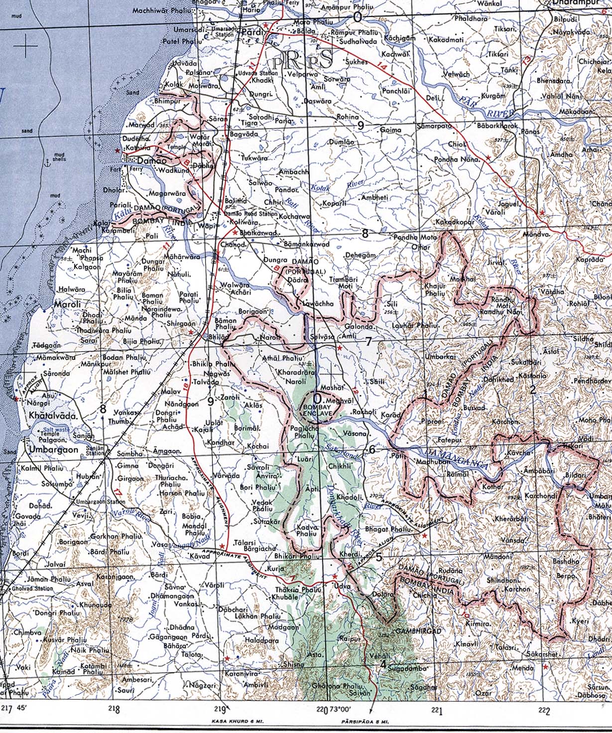
Formerly "Bombay Enclave, | Formerly "Bombay Enclave", Maghval was a British counter-enclave within the [[Portuguese India|Portuguese enclave]] within [[British India]] until independence.<ref>{{cite web|title= Megubaru, Former British territory, India |url= | ||
http://www.geocities.co.jp/SilkRoad-Lake/2917/india/meghval.html| accessdate=2013-10-06|author=Yoshida Ichiro}}</ref><ref>{{cite map|url=http://www.lib.utexas.edu/maps/middle_east_and_asia/damao_1956.jpg|year=1956| title = Damao (Daman) 1954 (Topographic Map) original scale 1:250,000. |accessdate=2013-10-06| quote= Portion of Navsari, Sheet NF 43-13, Series U502, U.S. Army Map Service compiled in 1954 and printed in 1956 (Perry–Castañeda Library Map Collection, University of Texas Libraries)}}</ref> | http://www.geocities.co.jp/SilkRoad-Lake/2917/india/meghval.html| accessdate=2013-10-06|author=Yoshida Ichiro}}</ref><ref>{{cite map|url=http://www.lib.utexas.edu/maps/middle_east_and_asia/damao_1956.jpg|year=1956| title = Damao (Daman) 1954 (Topographic Map) original scale 1:250,000. |accessdate=2013-10-06| quote= Portion of Navsari, Sheet NF 43-13, Series U502, U.S. Army Map Service compiled in 1954 and printed in 1956 (Perry–Castañeda Library Map Collection, University of Texas Libraries)}}</ref> | ||
==See also== | |||
* [[India–Bangladesh enclaves]] | |||
* [[List of enclaves and exclaves]] | |||
== References == | == References == | ||
| Line 70: | Line 77: | ||
[[Category:Villages in Valsad district]] | [[Category:Villages in Valsad district]] | ||
[[Category:Subnational enclaves and exclaves in India]] | |||
{{Valsad-geo-stub}} | {{Valsad-geo-stub}} | ||
Latest revision as of 10:51, 20 February 2026
Maghval
Megwal Meghwad | |
|---|---|
village | |
 Dadra and Nagar Haveli map in grey depicting the Gujarati enclave village of Maghval in cream | |
  Maghval Location in Gujarat, India  Maghval Maghval (India) | |
| Coordinates: 20°13′N 73°01′E / 20.21°N 73.02°E | |
| Country |  India India |
| State | Gujarat |
| District | Valsad district |
| Elevation | 16 m (52 ft) |
| Population (2011) | |
| • Total | 2,678 |
| Languages | |
| • Official | Gujarati, Marathi |
| Time zone | UTC+5:30 (IST) |
| PIN | 396240 |
| Vehicle registration | GJ |
| Nearest city | Silvassa |
Maghval, also known as Megwal and Meghwad, is a village in the Kaparada taluka of Valsad district in Gujarat State, India. It is a small counterenclave belonging to Gujarat, just south of Silvassa within Nagar Haveli which is an enclave in Gujarat and part of the Indian union territory of Dadra and Nagar Haveli and Daman and Diu.
In January 2022, the government of India announced plans for the Maghval enclave to become part of Dadra and Nagar Haveli and Daman and Diu alongside 3 other villages (which were sometimes isolated from the rest of Gujarat, but not from Dadra and Nagar Haveli, by monsoon floods). This would allow the sale of alcohol in the villages, as alcohol is restricted in Gujarat.[1] This process was later deferred.[2]
Geography[edit | edit source]
Maghval, though under the administrative purview of Gujarat, is surrounded by the union territory of Dadra and Nagar Haveli and Daman and Diu (DNHDD), outside the state boundary and a few kilometres from Silvassa in DNHDD. The village with 2,160 villagers (as of February 2018) has a rich landscape with the Daman Ganga River cutting through it, leaving a hilly stretch on one side and plains on the other.
History[edit | edit source]
Formerly "Bombay Enclave", Maghval was a British counter-enclave within the Portuguese enclave within British India until independence.[3][4]
See also[edit | edit source]
References[edit | edit source]
- ↑ "4 Gujarat villages will no more be dry". The Times of India. 20 January 2022. Retrieved 14 March 2024.
- ↑ "Merger of four Gujarat villages with Dadra deferred". The Times of India. 14 June 2022. ISSN 0971-8257. Retrieved 17 October 2023.
- ↑ Yoshida Ichiro. "Megubaru, Former British territory, India". Retrieved 6 October 2013.
- ↑ Damao (Daman) 1954 (Topographic Map) original scale 1:250,000 (Map). 1956. Retrieved 6 October 2013.
Portion of Navsari, Sheet NF 43-13, Series U502, U.S. Army Map Service compiled in 1954 and printed in 1956 (Perry–Castañeda Library Map Collection, University of Texas Libraries)
 | This article about a location in Valsad district, Gujarat, India is a stub. You can help Bharatpedia by expanding it. |