m Removed empty portal template using script |
general added layout for accuracy and improved wording |
||
| Line 1: | Line 1: | ||
{{Short description|Island in the Andaman Islands}} | |||
{{Use Indian English|date=September 2016}} | {{Use Indian English|date=September 2016}} | ||
{{Use dmy dates|date=September 2016}} | {{Use dmy dates|date=September 2016}} | ||
| Line 18: | Line 19: | ||
| archipelago = [[Andaman Islands]] | | archipelago = [[Andaman Islands]] | ||
| waterbody = [[Indian Ocean]] | | waterbody = [[Indian Ocean]] | ||
| area_km2 = | | area_km2 = 2780.7 | ||
| area_footnotes = <ref name="cit">{{cite web|url=http:// | | area_footnotes = <ref name="cit">{{cite web|url=http://islands.unep.ch/Tiarea.htm |title=Islands By Land Area |publisher=Islands.unep.ch |access-date=1 August 2010 |archive-url=https://web.archive.org/web/20221207141131/http://islands.unep.ch/Tiarea.htm |archive-date=7 December 2022}}</ref> | ||
| rank = | | rank = | ||
| length_km = 80 | | length_km = 80 | ||
| Line 54: | Line 55: | ||
| postal_code = 744202<ref>{{cite web|url=http://www.india-codes.com/pincodes/a-n-islands-pin-code |title=A&N Islands - Pincodes |date=22 September 2016 |accessdate=22 September 2016 |url-status=bot: unknown |archiveurl=https://web.archive.org/web/20140323224041/http://www.india-codes.com/pincodes/a-n-islands-pin-code |archivedate=23 March 2014 }}</ref> | | postal_code = 744202<ref>{{cite web|url=http://www.india-codes.com/pincodes/a-n-islands-pin-code |title=A&N Islands - Pincodes |date=22 September 2016 |accessdate=22 September 2016 |url-status=bot: unknown |archiveurl=https://web.archive.org/web/20140323224041/http://www.india-codes.com/pincodes/a-n-islands-pin-code |archivedate=23 March 2014 }}</ref> | ||
| area_code_type = Telephone code | | area_code_type = Telephone code | ||
| area_code = 031927 <ref name="allcodesindia">{{cite web|url=http://allcodesindia.in/stdcode/andaman+and+nicobar.php |publisher=allcodesindia.in|title=STD Codes of Andaman and Nicobar|accessdate=2016-09-23}}</ref> | | area_code = 031927 <ref name="allcodesindia">{{cite web|url=http://allcodesindia.in/stdcode/andaman+and+nicobar.php|publisher=allcodesindia.in|title=STD Codes of Andaman and Nicobar|accessdate=2016-09-23|archive-date=17 October 2019|archive-url=https://web.archive.org/web/20191017043815/http://allcodesindia.in/stdcode/andaman%2Band%2Bnicobar.php|url-status=live}}</ref> | ||
| website = {{URL|http://www.and.nic.in/}} | | website = {{URL|http://www.and.nic.in/}} | ||
| iso_code_type = [[ISO 3166-2:IN|ISO code]] | | iso_code_type = [[ISO 3166-2:IN|ISO code]] | ||
| Line 69: | Line 70: | ||
'''North Andaman Island''' is the northern island of [[Great Andaman]] of the [[Andaman Islands]].<ref>[http://www.and.nic.in/Know%20Andaman/ecostat2009/Island%20Wise%202008/N%20&%20M%20Andaman%20Islands/NORTH%20ANDAMAN%20ISLAND.pdf Island-wise Statistical Outline - 2008. NORTH ANDAMAN ISLAND]{{dead link|date=February 2018 |bot=InternetArchiveBot |fix-attempted=yes }} (PDF)</ref> | '''North Andaman Island''' is the northern island of [[Great Andaman]] of the [[Andaman Islands]].<ref>[http://www.and.nic.in/Know%20Andaman/ecostat2009/Island%20Wise%202008/N%20&%20M%20Andaman%20Islands/NORTH%20ANDAMAN%20ISLAND.pdf Island-wise Statistical Outline - 2008. NORTH ANDAMAN ISLAND]{{dead link|date=February 2018 |bot=InternetArchiveBot |fix-attempted=yes }} (PDF)</ref> | ||
It belongs to the [[North and Middle Andaman district|North and Middle Andaman]] administrative [[Districts of India|district]], part of the [[India]]n [[union territory]] of [[Andaman and Nicobar Islands]].<ref name="census">{{cite web|url=http://www.censusindia.gov.in/2011-VillageDirectory/Directory/short_code_rural_35.pdf|title=Village Code Directory: Andaman & Nicobar Islands|publisher=Census of India|accessdate=2011-01-16}}</ref> | It belongs to the [[North and Middle Andaman district|North and Middle Andaman]] administrative [[Districts of India|district]], part of the [[India]]n [[union territory]] of [[Andaman and Nicobar Islands]].<ref name="census">{{cite web|url=http://www.censusindia.gov.in/2011-VillageDirectory/Directory/short_code_rural_35.pdf|title=Village Code Directory: Andaman & Nicobar Islands|publisher=Census of India|accessdate=2011-01-16|archive-date=5 August 2016|archive-url=https://web.archive.org/web/20160805145307/http://censusindia.gov.in/2011-VillageDirectory/Directory/short_code_rural_35.pdf|url-status=live}}</ref> | ||
the island is lying {{convert|137|km|0|abbr=on}} north from [[Port Blair]]. | the island is lying {{convert|137|km|0|abbr=on}} north from [[Port Blair]]. | ||
==Geography== | ==Geography== | ||
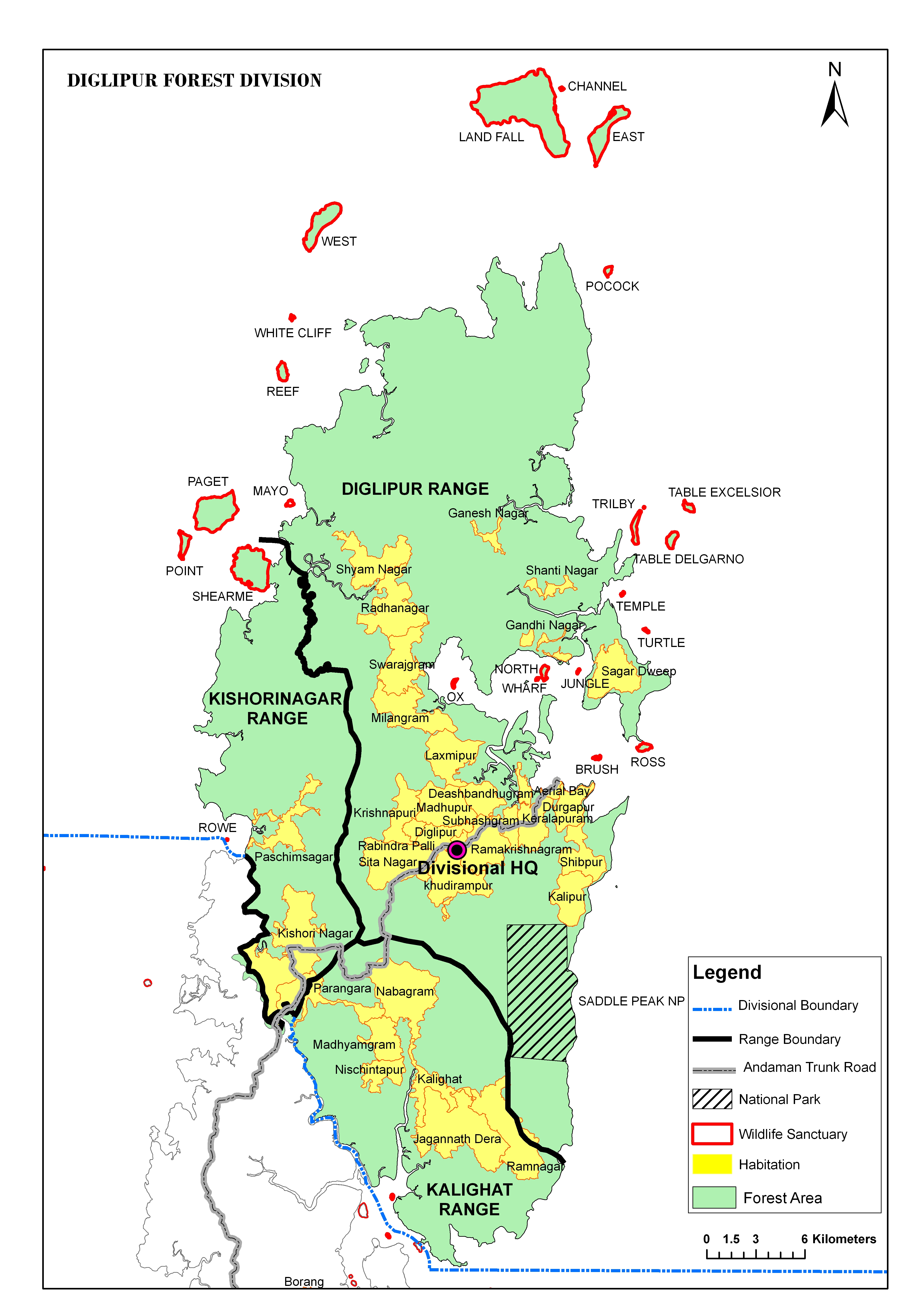
<ref> | <ref>{{Cite web |url=http://ls1.and.nic.in/doef/images/DiglipurForestDivision.jpg |title=map |access-date=15 June 2023 |archive-date=17 August 2019 |archive-url=https://web.archive.org/web/20190817205721/http://ls1.and.nic.in/doef/images/DiglipurForestDivision.jpg |url-status=live }}</ref> | ||
The island belongs to the [[Great Andaman]] group and lies north of [[Middle Andaman Island]]. | The island belongs to the [[Great Andaman]] group and lies north of [[Middle Andaman Island]]. Many small island groups surround its beaches. The island's main town is [[Diglipur]]. | ||
The island previously had an indigenous population of the [[Great Andamanese]], for example, the Bo, but they are no longer present: the island is populated by immigrants from the Indian mainland and their descendants. | The island previously had an indigenous population of the [[Great Andamanese]], for example, the Bo, but they are no longer present: the island is populated by immigrants from the Indian mainland and their descendants. | ||
| Line 98: | Line 99: | ||
*{{wikivoyage-inline|Andaman and Nicobar Islands}} | *{{wikivoyage-inline|Andaman and Nicobar Islands}} | ||
{{Wikivoyage|Diglipur}} | {{Wikivoyage|Diglipur}} | ||
{{Portal|India}} | |||
{{North and Middle Andaman district |state=collapsed}} | {{North and Middle Andaman district |state=collapsed}} | ||
| Line 104: | Line 105: | ||
[[Category:North Andaman Island| ]] | [[Category:North Andaman Island| ]] | ||
[[Category:Islands of North and Middle Andaman district]] | [[Category:Islands of North and Middle Andaman district]] | ||
Latest revision as of 15:03, 5 November 2025
 Map of North Andaman Island | |
  North Andaman  North Andaman | |
| Geography | |
|---|---|
| Location | Bay of Bengal |
| Coordinates | 13°15′N 92°56′E / 13.25°N 92.93°E |
| Archipelago | Andaman Islands |
| Adjacent bodies of water | Indian Ocean |
| Area | 2,780.7 km2 (1,073.6 sq mi)[1] |
| Length | 80 km (50 mi) |
| Width | 26 km (16.2 mi) |
| Coastline | 366 km (227.4 mi) |
| Highest elevation | 731 m (2398 ft)[2] |
| Highest point | Saddle Peak |
| Administration | |
| District | North and Middle Andaman |
| Island group | Andaman Islands |
| Island sub-group | Great Andaman |
| Taluk | Diglipur Taluk |
| Largest settlement | Diglipur (pop. 15,000) |
| Demographics | |
| Population | 42541 (2011) |
| Pop. density | 32.3/km2 (83.7/sq mi) |
| Ethnic groups | Andamanese |
| Additional information | |
| Time zone | |
| PIN | 744202[3] |
| Telephone code | 031927 [4] |
| ISO code | IN-AN-00[5] |
| Official website | www |
| Literacy | 84.4% |
| Avg. summer temperature | 30.2 °C (86.4 °F) |
| Avg. winter temperature | 23.0 °C (73.4 °F) |
| Sex ratio | 1.2♂/♀ |
| Census Code | 35.639.0004 |
| Official Languages | Hindi, English |
North Andaman Island is the northern island of Great Andaman of the Andaman Islands.[6] It belongs to the North and Middle Andaman administrative district, part of the Indian union territory of Andaman and Nicobar Islands.[7] the island is lying 137 km (85 mi) north from Port Blair.
Geography[edit | edit source]
[8] The island belongs to the Great Andaman group and lies north of Middle Andaman Island. Many small island groups surround its beaches. The island's main town is Diglipur.
The island previously had an indigenous population of the Great Andamanese, for example, the Bo, but they are no longer present: the island is populated by immigrants from the Indian mainland and their descendants.
The island is home to the highest point in the archipelago, Saddle Peak at 731 metres.[2]
North Andaman has fairly frequent large earthquakes, and suffered inundation from the 2004 Indian Ocean earthquake tsunami.
Administration[edit | edit source]
The entire island is part of Diglipur Taluk.[9]
Transportation[edit | edit source]
There is a small port at Durgapur, 6 km (4 mi) north of Diglipur, with regular services from Port Blair.
Economy[edit | edit source]
North Andaman is known for its marine life: the island's main industries are rice- and orange-growing.
References[edit | edit source]
- ↑ "Islands By Land Area". Islands.unep.ch. Archived from the original on 7 December 2022. Retrieved 1 August 2010.
- ↑ 2.0 2.1 Template:Cite enroute
- ↑ "A&N Islands - Pincodes". 22 September 2016. Archived from the original on 23 March 2014. Retrieved 22 September 2016.
{{cite web}}: CS1 maint: bot: original URL status unknown (link) - ↑ "STD Codes of Andaman and Nicobar". allcodesindia.in. Archived from the original on 17 October 2019. Retrieved 23 September 2016.
- ↑ Registration Plate Numbers added to ISO Code
- ↑ Island-wise Statistical Outline - 2008. NORTH ANDAMAN ISLAND[permanent dead link] (PDF)
- ↑ "Village Code Directory: Andaman & Nicobar Islands" (PDF). Census of India. Archived (PDF) from the original on 5 August 2016. Retrieved 16 January 2011.
- ↑ "map". Archived from the original on 17 August 2019. Retrieved 15 June 2023.
- ↑ "DEMOGRAPHIC – A&N ISLANDS" (PDF). andssw1.and.nic.in. Archived from the original (PDF) on 28 August 2017. Retrieved 23 September 2016.