











Ajay Kumar (talk | contribs) Created a new article |
improved citations for clarity and cleaned formatting based on references |
||
| Line 1: | Line 1: | ||
{{ | {{Short description|Expansion of auto-oriented, low-density development in suburbs}} | ||
{{Distinguish|text=[[Satellite city|Urban decentralisation]]}} | |||
{{Use mdy dates|date=November 2016}} | {{Use mdy dates|date=November 2016}} | ||
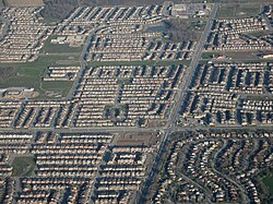
[[File:Chandler Arizona aerial.jpg|thumb|A typical suburban development in the United States, located in [[Chandler, Arizona]]]] | [[File:Chandler Arizona aerial.jpg|thumb|A typical suburban development in the United States, located in [[Chandler, Arizona]]]] | ||
[[File:Eixample de Palma.jpg|thumb|An urban development in [[Palma, Mallorca]]]] | [[File:Eixample de Palma.jpg|thumb|An urban development in [[Palma, Mallorca]]]] | ||
'''Urban sprawl''' (also known as '''suburban sprawl''' or '''urban encroachment''')<ref>{{Cite web |title=What Is Urban Encroachment? |url=https://sciencing.com/info-8758278-urban-encroachment.html |access-date=2021-01-15 |website=Sciencing |date=January 9, 2018 |language=en}}</ref> is defined as "the rapid expansion of the geographic extent of cities and towns, often characterized by low-density residential housing, single-use zoning, and increased reliance on the private automobile for transportation".<ref>{{Cite web |date=2025-10-27 |title=Urban sprawl {{!}} Definition, Examples, Problems, Causes, & Alternatives {{!}} Britannica |url=https://www.britannica.com/topic/urban-sprawl |access-date=2025-10-28 |website=www.britannica.com |language=en}}</ref> Urban sprawl has been described as the unrestricted growth in many [[urban area]]s of housing, commercial development, and roads over large expanses of land, with little concern for very dense [[urban planning]]. | |||
The term ''urban sprawl'' is highly politicized and almost always has negative connotations. It is criticized for causing [[environmental degradation]], intensifying [[housing segregation|segregation]], and undermining the vitality of existing urban areas, and is attacked on aesthetic grounds. | Urban sprawl refers to a special form of [[urbanization]], and it relates to the social and environmental consequences associated with such development.<ref>{{Cite journal |last1=Sarkodie |first1=Samuel Asumadu |last2=Owusu |first2=Phebe Asantewaa |last3=Leirvik |first3=Thomas |date=2020-03-05 |title=Global effect of urban sprawl, industrialization, trade and economic development on carbon dioxide emissions |journal=Environmental Research Letters |language=en |volume=15 |issue=3 |page=034049 |doi=10.1088/1748-9326/ab7640 |bibcode=2020ERL....15c4049S |issn=1748-9326 |doi-access=free|hdl=10037/17878 |hdl-access=free }}</ref> In modern times some [[suburban]] areas described as "sprawl" have less detached housing and higher density than the nearby [[core city]].<ref>{{cite web |title=Population of the Kansas City area |url=https://statisticalatlas.com/metro-area/Missouri/Kansas-City/Population |website=Statistical Atlas |access-date=19 December 2023}}</ref><ref>{{cite web |title=American housing survey housing characteristics |publisher=US Census |url=https://data.census.gov/table?q=DP04&g=160XX00US2053775,2938000,2938000 |access-date=19 December 2023}}</ref><ref>{{cite news |last=McCammon |first=Sarah |url=https://www.flatlandkc.org/people-places/kansas-city-booms-sprawls-forget/ |title=As Kansas City Booms And Sprawls, Trying Not To Forget Those In Between |work=[[National Public Radio]] |date=September 4, 2017 |access-date=19 December 2023}}</ref> Medieval suburbs suffered from the loss of protection of city walls, before the advent of [[industrial warfare]]. Sometimes the urban areas described as the most "sprawling" are the most densely populated.<ref name="Eidlin">{{cite magazine |last=Eidlin |first=Eric |url=https://www.accessmagazine.org/wp-content/uploads/sites/7/2016/01/access37sprawl.pdf |date=Fall 2010 |title=What Density Doesn't Tell Us About Sprawl |magazine=Access |number=17 |publisher=The Regents of the University of California |access-date=19 December 2023}}</ref><ref>{{cite book |title=Human geography: people, place, and culture |last1=Fouberg |first1=Erin Hogan |date=2012 |publisher=[[Wiley (publisher)|Wiley]] |last2=Murphy |first2=Alexander B. |last3=De Blij |first3=Harm J. |isbn=978-1-118-01869-9 |edition=10th |pages=560 |location=Hoboken |oclc=752286985}}</ref> | ||
The modern disadvantages and costs of urban sprawl include increased travel time, transport costs, pollution, and destruction of the countryside.<ref>{{Cite book |last=Caves |first=R. W. |title=Encyclopedia of the City |publisher=Routledge |url=https://archive.org/details/encyclopediacity00cave |url-access=limited |year=2004 |isbn=978-0-415-25225-6 |pages=[https://archive.org/details/encyclopediacity00cave/page/n666 626]}}</ref> The revenue for building and maintaining [[urban infrastructure]] in these areas are gained mostly through property and sales taxes. Most jobs in the US are now located in [[suburbs]] generating much of the revenue, although a lack of growth will require higher tax rates.<ref>{{cite web|url= https://www.planotomorrow.org/DocumentCenter/View/930/The-Connection_Final?bidId=|title=The land use and transportation connection Plano Texas|publisher=City of Plano|access-date=19 December 2023}}</ref><ref>{{cite web |url=http://www.newgeography.com/content/005264-suburbs-continue-dominate-jobs-and-job-growth |publisher=Bew Geography |title=Suburbs continue to dominate jobs and job growth |access-date=20 December 2023}}</ref><ref>{{cite book |author=Charles L. Marohn Jr. |date=2019 |title=Strong Towns: A Bottom-Up Revolution to Rebuild American Prosperity |url=https://books.google.com/books?id=sSSpDwAAQBAJ |publisher=[[Wiley (publisher)|Wiley]] |isbn=978-1-119-56481-2}}</ref> | |||
In [[Europe]], the term ''[[peri-urbanisation]]'' is often used to denote similar dynamics and phenomena, but the term ''urban sprawl'' is currently being used by the [[European Environment Agency]]. There is widespread disagreement about what constitutes sprawl and how to quantify it. For example, some commentators measure sprawl by [[Urban density|residential density]], using the average residential units per acre in a given area. Others associate it with [[decentralization]] (spread of population without a well-defined centre), discontinuity ([[Leapfrog development|leapfrogging]] development, as defined [[#Low-density|below]]), segregation of uses, and so forth. | |||
The term ''urban sprawl'' is highly politicized and almost always has negative connotations. It is criticized for causing [[environmental degradation]], intensifying [[housing segregation|segregation]], and undermining the vitality of existing urban areas, and is attacked on aesthetic grounds. Few people openly support urban sprawl as such, due to the pejorative connotations of the term. The term has become a rallying cry for managing urban growth.<ref>{{cite book |year=2013 |last1=James |first1=Paul |author-link1=Paul James (academic) |last2=Holden |first2=Meg |last3=Lewin |first3=Mary |last4=Neilson |first4=Lyndsay |last5=Oakley |first5=Christine |last6=Truter |first6=Art |last7=Wilmoth |first7=David |chapter=Managing Metropolises by Negotiating Mega-Urban Growth |title=Institutional and Social Innovation for Sustainable Urban Development |editor1=Harald Mieg |editor2=Klaus Töpfer |chapter-url=https://www.academia.edu/7207756 |publisher=[[Routledge]]}}</ref> | |||
==Definition== | ==Definition== | ||
[[File:Urban sprawl per country.png|thumb| | [[File:Urban sprawl per country.png|thumb|upright=1.3|Measures for urban sprawl in Europe: upper left the Dispersion of the built-up area (DIS), upper right the [[weighted urban proliferation]] (WUP)]] | ||
The term | The term ''urban sprawl'' was often used in the letters between Lewis Mumford and Frederic J. Osborn,<ref>The letters of Lewis Mumford and Frederic J. Osborn: a transatlantic dialogue, 1938-70, 1972</ref> firstly by Osborn in his 1941 letter to Mumford and later by Mumford, generally condemning the waste of agricultural land and landscape due to suburban expansions. The term was used in an article in ''[[The Times]]'' in 1955 as a negative comment on the state of [[London]]'s outskirts. Definitions of sprawl vary; researchers in the field acknowledge that the term lacks precision.<ref name=Audirac90>{{cite journal|last1=Audirac |first1=Ivonne|last2=Shermyen|first2=Anne H.|last3=Smith|first3=Marc T.|title=Ideal Urban Form and Visions of the Good Life Florida's Growth Management Dilemma|journal=Journal of the American Planning Association|date=December 31, 1990|volume=56 |issue=4|pages=470–482|doi=10.1080/01944369008975450}} p. 475.</ref> Batty et al. defined sprawl as "uncoordinated growth: the expansion of community without concern for its consequences, in short, unplanned, incremental urban growth which is often regarded unsustainable".<ref name=Batty>{{cite journal|last1=Batty |first1=Michael|last2=Besussi|first2=Elena|last3=Chin |first3=Nancy|title=Traffic, Urban Growth and Suburban Sprawl|journal=UCL Centre for Advanced Spatial Analysis Working Papers Series|date=November 2003|volume=70 |url=https://www.bartlett.ucl.ac.uk/casa/pdf/paper70.pdf |access-date=May 17, 2015|issn=1467-1298|archive-url=https://web.archive.org/web/20150926003140/https://www.bartlett.ucl.ac.uk/casa/pdf/paper70.pdf|archive-date=September 26, 2015}}</ref> Bhatta et al. wrote in 2010 that despite a dispute over the precise definition of sprawl, there is a "general consensus that urban sprawl is characterized by [an] unplanned and uneven pattern of growth, driven by a multitude of processes and leading to inefficient resource utilization".<ref name=Bhatta>{{cite journal |last1=Bhatta |first1=B. |last2=Saraswati|first2=S.|last3=Bandyopadhyay|first3=D. |title=Urban sprawl measurement from remote sensing data |journal=Applied Geography|date=December 2010|volume=30 |issue=4|pages=731–740|doi=10.1016/j.apgeog.2010.02.002 |bibcode=2010AppGe..30..731B }}</ref> | ||
Reid Ewing has shown that sprawl has typically been characterized as [[urban development]]s exhibiting at least one of the following characteristics: low-density or single-use development, strip development, scattered development, and/or [[Leapfrogging|leapfrog]] development (areas of development interspersed with vacant land).<ref name=UCL/> He argued that a better way to identify sprawl was to use indicators rather than characteristics because this was a more flexible and less arbitrary method.<ref name=Ewing97>{{cite journal|last1=Ewing|first1=Reid|title=Is Los Angeles-Style Sprawl Desirable?|journal=Journal of the American Planning Association | Reid Ewing has shown that sprawl has typically been characterized as [[urban development]]s exhibiting at least one of the following characteristics: low-density or single-use development, strip development, scattered development, and/or [[Leapfrogging|leapfrog]] development (areas of development interspersed with vacant land).<ref name=UCL/> He argued that a better way to identify sprawl was to use indicators rather than characteristics because this was a more flexible and less arbitrary method.<ref name=Ewing97>{{cite journal|last1=Ewing|first1=Reid |date=1997|title=Is Los Angeles-Style Sprawl Desirable?|journal=Journal of the American Planning Association |volume=63|issue=1|pages=107–126 |doi=10.1080/01944369708975728}}</ref> He proposed using "[[Accessibility (transport)|accessibility]]" and "lack of functional open space" as indicators.<ref name=Ewing97/> Ewing's approach has been criticized for assuming that sprawl is defined by negative characteristics.<ref name=UCL>{{cite journal |last1=Chin|first1=Nancy |title=Unearthing the Roots of Urban Sprawl: A Critical Analysis of Form, Function and Methodology |date=March 2002 |journal=University College London Centre for Advanced Spatial Analysis Working Papers Series|volume=47 |url=https://www.bartlett.ucl.ac.uk/casa/pdf/paper47.pdf |access-date=April 19, 2015|issn=1467-1298|archive-url=https://web.archive.org/web/20160304044026/https://www.bartlett.ucl.ac.uk/casa/pdf/paper47.pdf|archive-date=March 4, 2016 }}</ref> | ||
What constitutes sprawl may be considered a matter of degree and will always be somewhat subjective under many definitions of the term.<ref name=Ewing97/> Ewing has also argued that suburban development does not, [[per se (terminology)|per se]], constitute sprawl depending on the form it takes,<ref name=Ewing97/> although Gordon & Richardson have argued that the term is sometimes used synonymously with [[suburbanization]] in a pejorative way.<ref name=G&R>{{cite journal|last1=Gordon|first1=Peter|last2=Richardson|first2=Harry|title=Are Compact Cities a Desirable Planning Goal?|journal=Journal of the American Planning Association|date=1997|volume=63|issue=1|pages=95–106|doi=10.1080/01944369708975727}}</ref> | What constitutes sprawl may be considered a matter of degree and will always be somewhat subjective under many definitions of the term.<ref name=Ewing97/> Ewing has also argued that suburban development does not, [[per se (terminology)|per se]], constitute sprawl depending on the form it takes,<ref name=Ewing97/> although Gordon & Richardson have argued that the term is sometimes used synonymously with [[suburbanization]] in a pejorative way.<ref name=G&R>{{cite journal|last1=Gordon|first1=Peter |last2=Richardson|first2=Harry|title=Are Compact Cities a Desirable Planning Goal?|journal=Journal of the American Planning Association|date=1997|volume=63|issue=1|pages=95–106|doi=10.1080/01944369708975727}}</ref> | ||
===Examples and counterexamples=== | ===Examples and counterexamples=== | ||
According to the National Resources Inventory (NRI), about {{Convert|44|e6acre|sqmi km2|abbr=unit}} of land in the United States was developed between 1982 and 2017.<ref>{{Cite book|last=U.S. Department of Agriculture|url=https://www.nrcs.usda.gov/wps/PA_NRCSConsumption/download/?cid=nrcseprd1657225&ext=pdf|title=Summary Report: 2017 National Resources Inventory|publisher=Natural Resources Conservation Service|year=2020|location=Washington, D.C.|at=2-6|format=PDF}}</ref> Presently, the NRI classifies approximately 100,000 more square kilometres (40,000 square miles) (an area approximately the size of [[Kentucky]]) as developed than [[United States Census Bureau|the Census Bureau]] classifies as urban. The difference in the NRI classification is that it includes rural development, which by definition cannot be considered to be "urban" sprawl. Currently, according to the [[United States Census, 2000|2000 Census]], approximately 2.6 percent of the U.S. land area is urban.<ref>Lubowski | According to the National Resources Inventory (NRI), about {{Convert|44|e6acre|sqmi km2|abbr=unit}} of land in the United States was developed between 1982 and 2017.<ref>{{Cite book|last=U.S. Department of Agriculture |url=https://www.nrcs.usda.gov/wps/PA_NRCSConsumption/download/?cid=nrcseprd1657225&ext=pdf|archive-url=https://web.archive.org/web/20210311150940/https://www.nrcs.usda.gov/wps/PA_NRCSConsumption/download/?cid=nrcseprd1657225&ext=pdf|archive-date=March 11, 2021|title=Summary Report: 2017 National Resources Inventory|publisher=Natural Resources Conservation Service|year=2020 |location=Washington, D.C.|at=2-6|format=PDF}}</ref> Presently, the NRI classifies approximately 100,000 more square kilometres (40,000 square miles) (an area approximately the size of [[Kentucky]]) as developed than [[United States Census Bureau|the Census Bureau]] classifies as urban. The difference in the NRI classification is that it includes rural development, which by definition cannot be considered to be "urban" sprawl. Currently, according to the [[United States Census, 2000|2000 Census]], approximately 2.6 percent of the U.S. land area is urban.<ref>{{cite report |last1=Lubowski |first1=Ruben N. |first2=Marlow |last2=Vesterby |first3=Shawn |last3=Bucholtz |first4=Alba |last4=Baez |first5=Michael J. |last5=Roberts |date=May 31, 2006 |url=http://www.ers.usda.gov/publications/EIB14/ |title=Major Uses of Land in the United States, 2002 |publisher=[[Economic Research Service]] |archive-url=https://web.archive.org/web/20070409092844/http://www.ers.usda.gov/Publications/EIB14/ |archive-date=April 9, 2007 |access-date=February 7, 2008}}</ref>{{Update inline|date=April 2021}} Approximately 0.8 percent of the nation's land is in the 37 urbanized areas with more than 1,000,000 population. In 2002, these 37 urbanized areas supported around 40% of the total American population.<ref>{{cite web |url=http://www.demographia.com/db-ua2000pop.htm |title=USA Urbanized Areas: 2000 Ranked by Population (All Areas) |website=Demographia |access-date=February 8, 2008}}</ref>{{Update inline|date=April 2021}} | ||
Nonetheless, some [[urban area]]s like [[Detroit]] have expanded geographically even while losing population. But it was not just urbanized areas in the U.S. that lost population and sprawled substantially. According to data in "Cities and Automobile Dependence" by Kenworthy and Laube (1999), urbanized area population losses occurred while there was an expansion of sprawl between 1970 and 1990 in [[Amsterdam | Nonetheless, some [[urban area]]s like [[Detroit]] have expanded geographically even while losing population. But it was not just urbanized areas in the U.S. that lost population and sprawled substantially. According to data in "Cities and Automobile Dependence" by Kenworthy and Laube (1999), urbanized area population losses occurred while there was an expansion of sprawl between 1970 and 1990 in [[Amsterdam]], Netherlands; [[Brussels]], Belgium; [[Copenhagen]], Denmark; [[Frankfurt]], [[Hamburg]] and [[Munich]], Germany; and [[Zürich]], Switzerland, albeit without the dismantling of infrastructure that occurred in the United States.{{Citation needed|date=January 2021}} | ||
[[File:Satellite Image of Los Angeles from Sentinel-2 2021-08-03.jpg|thumb|Despite its | [[File:Satellite Image of Los Angeles from Sentinel-2 2021-08-03.jpg|thumb|Despite its urban sprawl and [[car culture]], Los Angeles is the densest major built-up urban area in the United States.]] | ||
Despite | Despite its sprawl, [[Los Angeles metropolitan area|Metropolitan Los Angeles]] is the densest major urban area (over 1,000,000 population) in the US, being denser than the New York urban area and the San Francisco urban area.<ref name=Eidlin/><ref>{{cite web |url=https://www.census.gov/newsroom/releases/archives/2010_census/cb12-50.html|title=Growth in Urban Population Outpaces Rest of Nation, Census Bureau Reports |access-date=October 20, 2013|publisher=US Census}}</ref><ref>{{cite web |url=http://la.curbed.com/2015/2/17/9991042/los-angeles-is-the-least-sprawling-big-city-in-the-us |archive-url=https://web.archive.org/web/20160424022237/http://la.curbed.com/2015/2/17/9991042/los-angeles-is-the-least-sprawling-big-city-in-the-us |url-status=dead |archive-date=April 24, 2016 |title=Los Angeles is the Least Sprawling Big City in the US|last1=Barragan |first1=Bianca|website=Curbed |publisher=Vox Media|access-date=25 January 2017 |date=2015-02-17}}</ref> Most of metropolitan Los Angeles is built at more uniform low to moderate density, leading to a much higher overall density for the entire region. This is in contrast to New York, San Francisco or Chicago which have compact, high-density cores surrounded by areas of very low-density suburban periphery, such as eastern [[Suffolk County, New York|Suffolk County]] in the New York metro area and [[Marin County, California|Marin County]] in the San Francisco [[Bay Area]]. | ||
Some cases of sprawl challenge the definition of the term and what conditions are necessary for urban growth to be considered sprawl. Metropolitan regions such as [[Greater Mexico City]],<ref>{{cite journal|last=Monkkonen|first=Paavo|year=2011|title=Do Mexican Cities Sprawl? Housing Finance Reform and Changing Patterns of Urban Growth|journal=Urban Geography|volume=32|issue=3|pages=406–423|doi=10.2747/0272-3638.32.3.406|s2cid=144340604}}</ref> [[National Capital Region (India)|Delhi National Capital Region]]<ref>{{Cite news|url=https://www.citylab.com/solutions/2016/12/sprawl-will-cost-india-18-trillion-per-year-by-2050/509573/|title=India Can't Afford to Get Urbanization Wrong|work=CityLab|access-date=2018-06-27|language=en-US}}</ref> | Some cases of sprawl challenge the definition of the term and what conditions are necessary for urban growth to be considered sprawl. Metropolitan regions such as [[Greater Mexico City]],<ref>{{cite journal|last=Monkkonen |first=Paavo|year=2011|title=Do Mexican Cities Sprawl? Housing Finance Reform and Changing Patterns of Urban Growth|journal=Urban Geography|volume=32|issue=3 |pages=406–423|doi=10.2747/0272-3638.32.3.406 |s2cid=144340604}}</ref> [[National Capital Region (India)|Delhi National Capital Region]]<ref>{{Cite news|url=https://www.citylab.com/solutions/2016/12/sprawl-will-cost-india-18-trillion-per-year-by-2050/509573/|title=India Can't Afford to Get Urbanization Wrong|work=CityLab|access-date=2018-06-27|language=en-US|archive-date=May 17, 2020|archive-url=https://web.archive.org/web/20200517143029/https://www.citylab.com/solutions/2016/12/sprawl-will-cost-india-18-trillion-per-year-by-2050/509573/}}</ref> [[Beijing]], and the [[Greater Tokyo Area]] are often regarded as sprawling despite being relatively dense and mixed use.{{Citation needed|date=January 2021}} | ||
== History == | == History == | ||
Many theories speculate as to the reason for the creation of urban sprawl. The theory of "flight from blight" explains that aspects of living in urban areas, such as high taxes, crime rates, poor infrastructure and school qualities lead to many people moving out of urban areas and into surrounding suburban | Many theories speculate as to the reason for the creation of urban sprawl. The theory of "flight from blight" explains that aspects of living in urban areas, such as high taxes, crime rates, poor infrastructure and school qualities lead to many people moving out of urban areas and into surrounding suburban areas.<ref name=":0">{{Cite web|last=Wassmer|first=Robert W.|date=January 10, 2005|title=Causes of Urban Sprawl (Decentralization) in the United States: Natural Evolution, Flight from Blight, and the Fiscalization of Land Use |url=https://www.researchgate.net/publication/229048043 |url-status=live |archive-url=https://web.archive.org/web/20211105092838/https://www.researchgate.net/publication/229048043_Causes_of_urban_sprawl_decentralization_in_the_United_States_natural_Evolution_flight_from_blight_and_the_fiscalization_of_land_use |archive-date=November 5, 2021}}</ref> According to ''[[The Limits to Growth]]'', reasons why wealthier people move to suburbs include noise, pollution, crime, drug addiction, poverty, labor strikes, and breakdown of social services.<ref>{{Cite web |title=The Limits to Growth: A report for the Club of Rome's project on the predicament of mankind |website=collections.dartmouth.edu |url=https://collections.dartmouth.edu/teitexts/meadows/diplomatic/meadows_ltg-diplomatic.html |access-date=2022-07-18}}</ref> | ||
Others suggest that | Others suggest that urban sprawl is a natural product of population increases, higher wages, and therefore better access to housing. Improvement in transportation also means that individuals are able to live further from large cities and industrial hubs, thus increasing demand for better housing further from the noise of cities. This leads to the creation of sprawling residential land development surrounding densely packed urban areas.<ref>{{Cite journal|last=Brueckner|first=Jan K.|date=April 2000 |title=Urban Sprawl: Diagnosis and Remedies |journal=International Regional Science Review|volume=23 |issue=2 |pages=160–171|doi=10.1177/016001700761012710 |bibcode=2000IRSRv..23..160B |s2cid=153422102|issn=0160-0176 |language=en}}</ref> | ||
== Characteristics == | == Characteristics == | ||
Despite the lack of a clear agreed upon description of what defines sprawl most definitions often associate the following characteristics with sprawl.{{Citation needed|date=January 2021}} | Despite the lack of a clear agreed upon description of what defines sprawl most definitions often associate the following characteristics with sprawl.{{Citation needed|date=January 2021}} | ||
[[File:BosWash-Night-Labeled.png|upright=1. | [[File:BosWash-Night-Labeled.png|upright=1.0|thumb|This picture shows the [[metropolitan area]]s of the [[Northeast Megalopolis]] of the United States demonstrating urban sprawl, including far-flung [[suburb]]s and [[exurb]]s illuminated at night.]] | ||
=== Single-use development === | === Single-use development === | ||
{{Main|Single-use zoning}} | {{Main|Single-use zoning}} | ||
This refers to a situation where commercial, [[residential area|residential]], institutional and [[industrial region|industrial areas]] are separated from one another. Consequently, large tracts of land are devoted to a single use and are segregated from one another by open space, infrastructure, or other barriers. As a result, the places where people live, work, shop, and recreate are far from one another, usually to the extent that walking, transit use and bicycling are impractical, so all these activities generally require a car.<ref name="cdcreport"> | This refers to a situation where commercial, [[residential area|residential]], institutional and [[industrial region|industrial areas]] are separated from one another. Consequently, large tracts of land are devoted to a single use and are segregated from one another by open space, infrastructure, or other barriers. As a result, the places where people live, work, shop, and recreate are far from one another, usually to the extent that walking, transit use and bicycling are impractical, so all these activities generally require a car.<ref name="cdcreport">Frumkin, Howard (May–June 2002). Urban Sprawl and Public Health (PDF) (Report). [[Centers for Disease Control and Prevention]]. Retrieved February 7, 2008</ref> The degree to which different [[land use]]s are mixed together is often used as an indicator of sprawl in studies of the subject.<ref name=Bhatta/> | ||
According to this criterion, China's [[urbanization]] can be classified as "high-density sprawl", a seemingly self-contradictory term coined by [[New Urbanism|New Urbanist]] [[Peter Calthorpe]]. He explains that despite the high-rise buildings, China's superblocks (huge residential blocks) are largely single-use and surrounded by giant arterial roads, which detach different functions of a city and create an environment unfriendly to pedestrians.<ref>{{Cite web |author=[[Peter Calthorpe]] |url=https://www.cnu.org/publicsquare/china-chokes-high-density-sprawl |title=China chokes on high-density sprawl |work=Public Square: A CNU Journal |publisher=Congress for the New Urbanism |date=July 7, 2016}}</ref><ref>{{Cite book |author=Peter Calthorpe | According to this criterion, China's [[urbanization]] can be classified as "high-density sprawl", a seemingly self-contradictory term coined by [[New Urbanism|New Urbanist]] [[Peter Calthorpe]]. He explains that despite the high-rise buildings, China's superblocks (huge residential blocks) are largely single-use and surrounded by giant arterial roads, which detach different functions of a city and create an environment unfriendly to pedestrians.<ref>{{Cite web |author=[[Peter Calthorpe]] |url=https://www.cnu.org/publicsquare/china-chokes-high-density-sprawl |title=China chokes on high-density sprawl |work=Public Square: A CNU Journal |publisher=Congress for the New Urbanism |date=July 7, 2016}}</ref><ref>{{Cite book |author=Peter Calthorpe |year=2016 |chapter=Urbanism and Global Sprawl |title=Can a City Be Sustainable? |series=[[State of the World (book series)|State of the World]] |pages=91–108 |isbn=978-1-61091-756-8 |publisher=Island Press |location=Washington, DC |doi=10.5822/978-1-61091-756-8_7}}</ref> | ||
=== Job sprawl and spatial mismatch === | === Job sprawl and spatial mismatch === | ||
[[File:Traffic jam Marginal Pinheiros 6122 SAO 07 2009.jpg|thumb|left|[[Traffic congestion]] in sprawling [[São Paulo]], [[Brazil]], which, according to ''[[Time (magazine)|Time]]'' magazine, has the world's worst traffic jams | [[File:Traffic jam Marginal Pinheiros 6122 SAO 07 2009.jpg|thumb|left|[[Traffic congestion]] in sprawling [[São Paulo]], [[Brazil]], which, according to ''[[Time (magazine)|Time]]'' magazine, has the world's worst traffic jams<ref name=Times_SP>{{Cite magazine|url= http://www.time.com/time/world/article/0,8599,1733872,00.html |archive-url= https://web.archive.org/web/20080423172358/http://www.time.com/time/world/article/0,8599,1733872,00.html |archive-date= April 23, 2008 |title=The World's Worst Traffic Jams|magazine=Time|date=April 21, 2008|access-date=September 4, 2014|author= Andrew Downie}}</ref>]] | ||
Job sprawl is another land use symptom of urban sprawl and [[automobile dependency|car-dependent]] communities. It is defined as low-density, geographically spread-out patterns of employment, where the majority of jobs in a given metropolitan area are located outside of the main city's [[central business district]] (CBD), and increasingly in the suburban periphery. It is often the result of urban disinvestment, the geographic freedom of employment location allowed by predominantly car-dependent commuting patterns of many American suburbs, and many companies' desire to locate in low-density areas that are often more affordable and offer potential for expansion. [[Spatial mismatch]] is related to job sprawl and economic [[environmental justice]]. Spatial mismatch is defined as the situation where poor urban, predominantly minority citizens are left without easy access to entry-level jobs, as a result of increasing job sprawl and limited transportation options to facilitate a [[reverse commute]] to the suburbs. | Job sprawl is another land use symptom of urban sprawl and [[automobile dependency|car-dependent]] communities. It is defined as low-density, geographically spread-out patterns of employment, where the majority of jobs in a given metropolitan area are located outside of the main city's [[central business district]] (CBD), and increasingly in the suburban periphery. It is often the result of urban [[disinvestment]], the geographic freedom of employment location allowed by predominantly car-dependent commuting patterns of many American suburbs, and many companies' desire to locate in low-density areas that are often more affordable and offer potential for expansion. [[Spatial mismatch]] is related to job sprawl and economic [[environmental justice]]. Spatial mismatch is defined as the situation where poor urban, predominantly minority citizens are left without easy access to entry-level jobs, as a result of increasing job sprawl and limited transportation options to facilitate a [[reverse commute]] to the suburbs. | ||
Job sprawl has been documented | Job sprawl has been measured and documented in various ways. It has been shown to be a growing trend in America's metropolitan areas.<ref>{{cite web |title=Residential Construction Trends in America's Metropolitan Regions |url=https://www.epa.gov/smartgrowth/residential-construction-trends-americas-metropolitan-regions |archive-url=https://web.archive.org/web/20150921211512/http://www2.epa.gov/smartgrowth/residential-construction-trends-americas-metropolitan-regions |archive-date=September 21, 2015 |date=2016-07-27 |website=Smart Growth |publisher=U.S. Environmental Protection Agency (EPA) |location=Washington, D.C.}}</ref> The [[Brookings Institution]] has published multiple articles on the topic. In 2005, author [[Michael Stoll]] defined job sprawl simply as jobs located more than {{convert|5|mi|km|adj=on}} radius from the CBD, and measured the concept based on year 2000 [[U.S. census]] data.<ref name=Stoll>{{cite book |last=Stoll |first=Michael A. |title=Job Sprawl and the Spatial Mismatch between Blacks and Jobs |location=Washington D.C. |publisher=Brookings Institution, Metropolitan Policy Program |date=2005 |url=http://www.brookings.edu/reports/2005/02metropolitanpolicy_stoll.aspx |access-date=January 22, 2010 |archive-url=https://web.archive.org/web/20080706103216/http://www.brookings.edu/reports/2005/02metropolitanpolicy_stoll.aspx |archive-date=July 6, 2008 }}</ref> Other ways of measuring the concept with more detailed rings around the CBD include a 2001 article by Edward Glaeser<ref name=Glaeser>{{cite book |last=Glaeser |first=Edward |date=2001 |title=Job Sprawl: Employment Location in U.S. Metropolitan Areas |location=Washington D.C. |publisher=Brookings Institution, Metropolitan Policy Program. |url=http://www.brookings.edu/reports/2001/07_employment_glaeser.aspx |archive-url=http://arquivo.pt/wayback/20160515085220/http://www.brookings.edu/reports/2001/07_employment_glaeser.aspx |archive-date=2016-05-15 |access-date=January 22, 2010 }}</ref> and Elizabeth Kneebone's 2009 article, which show that sprawling urban peripheries are gaining employment while areas closer to the CBD are losing jobs.<ref name=Kneebone>{{cite book |last=Kneebone |first=Elizabeth |title=Job Sprawl Revisited: The Changing Geography of Metropolitan Employment |location=Washington D.C. |publisher=Brookings Institution |date=2009 |url=http://www.brookings.edu/reports/2009/0406_job_sprawl_kneebone.aspx |access-date=January 22, 2010 |archive-url=https://web.archive.org/web/20100222104135/http://www.brookings.edu/reports/2009/0406_job_sprawl_kneebone.aspx |archive-date=February 22, 2010 }}</ref> These two authors used three geographic rings limited to a {{convert|35|mi|km|adj=on}} radius around the CBD: {{convert|3|mi|km}} or less, 3 to {{convert|10|mi|km}}, and 10 to {{convert|35|mi|km}}. Kneebone's study showed the following nationwide breakdown for the largest metropolitan areas in 2006: 21.3% of jobs located in the inner ring, 33.6% of jobs in the 3–10 mile ring, and 45.1% in the 10–35 mile ring. This compares to the year 1998 – 23.3%, 34.2%, and 42.5% in those respective rings. The study shows CBD employment share shrinking, and job growth focused in the suburban and exurban outer metropolitan rings. | ||
===Low-density=== | ===Low-density=== | ||
[[File:Bean Station neighborhoods I.jpg|thumb|Low-density housing placed between large farms in an [[exurban]] community in Tennessee]] | [[File:Bean Station neighborhoods I.jpg|thumb|Low-density housing placed between large farms in an [[exurban]] community in Tennessee]] | ||
Sprawl often refers to low-[[population density|density]] [[land development|development]].<ref name=UCL/> There is no precise definition of "low density", but it might commonly mean [[ | Sprawl often refers to low-[[population density|density]] [[land development|development]].<ref name=UCL/> There is no precise definition of "low density", but it might commonly mean [[single-family detached home]]s on large lots. Such buildings usually have fewer stories and are spaced farther apart, separated by [[lawn]]s, [[landscaping]], roads or parking lots. In the United States 2–4 houses per acre (5–10 per hectare) might be considered low-density while in the UK 8–12 per acre (or 20–30 per hectare) would still be considered low-density.<ref name=UCL/> Because more automobiles are used in the USA, much more land is designated for parking. The impact of low density development in many communities is that developed or "urbanized" land is increasing at a faster rate than the population is growing.{{citation needed|date=April 2015}} | ||
Overall density is often lowered by "[[Leapfrogging|leapfrog]] development". This term refers to the relationship, or lack of it, between subdivisions. Such developments are typically separated by large [[green belt]]s, i.e. tracts of undeveloped land, resulting in an overall density far lower even than the low density indicated by localized per-acre measurements. This is a 20th and 21st century phenomenon generated by the current custom of requiring a developer to provide subdivision infrastructure as a condition of development.<ref>DeGrove, John and Robyne Turner (1991), "Local Government in Florida: Coping with Massive and Sustained Growth" in Huckshorn, R. (ed.) Government and Politics in Florida. University of Florida Press, Gainesville.</ref> Usually, the developer is required to set aside a certain percentage of the developed land for public use, including roads, parks and schools. In the past, when a [[local government]] built all the streets in a given location, the town could expand without interruption and with a coherent circulation system, because it had [[eminent domain|condemnation power]]. Private developers generally do not have such power (although they can sometimes find local governments willing to help), and often choose to develop on the tracts that happen to be for sale at the time they want to build, rather than pay extra or wait for a more appropriate location. | Overall density is often lowered by "[[Leapfrogging|leapfrog]] development". This term refers to the relationship, or lack of it, between subdivisions. Such developments are typically separated by large [[green belt]]s, i.e. tracts of undeveloped land, resulting in an overall density far lower even than the low density indicated by localized per-acre measurements. This is a 20th and 21st century phenomenon generated by the current custom of requiring a developer to provide subdivision infrastructure as a condition of development.<ref>DeGrove, John and Robyne Turner (1991), "Local Government in Florida: Coping with Massive and Sustained Growth" in Huckshorn, R. (ed.) Government and Politics in Florida. University of Florida Press, Gainesville.</ref> Usually, the developer is required to set aside a certain percentage of the developed land for public use, including roads, parks and schools. In the past, when a [[local government]] built all the streets in a given location, the town could expand without interruption and with a coherent circulation system, because it had [[eminent domain|condemnation power]]. Private developers generally do not have such power (although they can sometimes find local governments willing to help), and often choose to develop on the tracts that happen to be for sale at the time they want to build, rather than pay extra or wait for a more appropriate location. | ||
Some research argues that religious ideas about how humans should live (and die) promote low-density development and may contribute to urban sprawl.<ref>{{Cite book|title=Theology and urban sustainability|last=Allam | Some research argues that religious ideas about how humans should live (and die) promote low-density development and may contribute to urban sprawl.<ref>{{Cite book |title=Theology and urban sustainability|last=Allam |first=Zaheer |date=2020 |publisher=Springer|isbn=978-3-030-29673-5|location=Cham|oclc=1120695363}}</ref><ref>{{Cite journal|last=Scarrow|first=Ryan |s2cid=202558093 |date=September 2019|title=Graves or people|journal=Nature Sustainability|language=en|volume=2|issue=9 |page=787 |doi=10.1038/s41893-019-0383-2|issn=2398-9629|doi-access=free|bibcode=2019NatSu...2..787S}}</ref> | ||
===Conversion of agricultural land to urban use=== | ===Conversion of agricultural land to urban use=== | ||
Land for sprawl is often taken from [[soil fertility|fertile]] [[agricultural land]]s, which are often located immediately surrounding cities; the extent of modern sprawl has consumed a large amount of the most productive agricultural land,<ref>{{cite journal|last1=Krannich|first1=Jess M.|title=Modern Disaster: Agricultural Land, Urban Growth, and the Need for a Federally Organized Comprehensive Land Use Planning Model|journal=Cornell Journal of Law and Public Policy|date=2006|volume=16|issue= | Land for sprawl is often taken from [[soil fertility|fertile]] [[agricultural land]]s, which are often located immediately surrounding cities; the extent of modern sprawl has consumed a large amount of the most productive agricultural land,<ref>{{cite journal |last1=Krannich|first1=Jess M.|title=A Modern Disaster: Agricultural Land, Urban Growth, and the Need for a Federally Organized Comprehensive Land Use Planning Model |journal=Cornell Journal of Law and Public Policy |date=Fall 2006|volume=16 |issue=2|at=Article 2|url= https://scholarship.law.cornell.edu/cgi/viewcontent.cgi?article=1104&context=cjlpp|access-date=June 8, 2015}}</ref> as well as forest, desert and other wilderness areas.<ref>{{cite journal|last1=Hasse|first1=John E. |last2=Lathrop |first2=Richard G.|date=2003|title=Land resource impact indicators of urban sprawl|journal=Applied Geography|volume=23|issue=2–3 |pages=159–175 |doi=10.1016/j.apgeog.2003.08.002|bibcode=2003AppGe..23..159H }}</ref> In the United States the seller may [[tax avoidance|avoid tax]] on profit by using a [[tax break]] exempting [[like-kind exchange]]s from [[capital gains tax]]; proceeds from the sale are used to purchase agricultural land elsewhere and the transaction is treated as a "swap" or trade of like assets and no tax is due. Thus urban sprawl is subsidized by the tax code.<ref>{{cite news|title=Major Companies Push the Limits of a Tax Break |author=David Kocieniewski|date=January 6, 2013 |url=https://www.nytimes.com/2013/01/07/business/economy/companies-exploit-tax-break-for-asset-exchanges-trial-evidence-shows.html|access-date=January 7, 2013 |newspaper=The New York Times |quote=With hundreds of thousands of transactions a year, it is hard to gauge the true cost of the tax break for so-called like-kind exchanges, like those used by Cendant, General Electric and Wells Fargo.}}</ref> In China, land has been converted from rural to urban use in advance of demand, leading to vacant rural land intended for future development, and eventual urban sprawl.<ref>{{Cite journal |last1=Fang |first1=Yiping|last2=Pal|first2=Anirban|date=2016-07-07 |title=Drivers of urban sprawl in urbanizing China – a political ecology analysis|journal=Environment and Urbanization|language=en|volume=28 |issue=2|pages=599–616 |doi=10.1177/0956247816647344|issn=0956-2478 |url=https://pdxscholar.library.pdx.edu/cgi/viewcontent.cgi?article=1163&context=usp_fac|doi-access=free |bibcode=2016EnUrb..28..599F}}</ref> | ||
===Housing subdivisions=== | ===Housing subdivisions=== | ||
[[File:Derry and Thompson.JPG|thumb|right|Sprawl in [[Milton, Ontario|Milton]], [[Ontario]]. This photograph is an example of Canadian exurban development, though recently attempts are made to reduce this type of development in many major cities.]] | [[File:Derry and Thompson.JPG|thumb|right|Sprawl in [[Milton, Ontario|Milton]], [[Ontario]]. This photograph is an example of Canadian exurban development, though recently attempts are made to reduce this type of development in many major cities.]] | ||
[[Housing subdivision]]s are large tracts of land consisting entirely of newly built residences. [[New Urbanism|New Urbanist]] architectural firm [[Duany Plater-Zyberk & Company]] | [[Housing subdivision]]s are large tracts of land consisting entirely of newly built residences. [[New Urbanism|New Urbanist]] architectural firm [[Duany Plater-Zyberk & Company]] states that housing subdivisions "are sometimes called villages, towns, and neighbourhoods by their developers, which is misleading since those terms denote places that are not exclusively residential".<ref name=duany2001>{{cite book|last1=Duany|first1=Andres |last2=Plater-Zyberk|first2=Elizabeth|last3=Speck |first3=Jeff |title=Suburban Nation: The Rise of Sprawl and the Decline of the American Dream|date=2001 |publisher=Farrar Straus & Giroux |location=New York |isbn=978-0-86547-606-6|url-access=registration |url=https://archive.org/details/suburbannationri00duan}}</ref> They are also referred to as developments. Land developers may adopt [[tract housing]] as a cost-saving measure, which often results in a lack of architectural diversity across houses.<ref>{{Cite news |last=Kershner |first=Kate |date=17 May 2024 |title=Why do cookie-cutter neighborhoods exist? |language=en |work=HowStuffWorks |url=http://home.howstuffworks.com/home-improvement/construction/projects/why-cookie-cutter-neighborhoods-exist1.htm |access-date=2 July 2025}}</ref> | ||
Subdivisions often incorporate curved roads and [[cul-de-sac]]s. These subdivisions may offer only a few places to enter and exit the development, causing traffic to use high volume collector streets. All trips, no matter how short, must enter the collector road in a suburban system.<ref name=duany2001/> | Subdivisions often incorporate curved roads and [[cul-de-sac]]s. These subdivisions may offer only a few places to enter and exit the development, causing traffic to use high volume collector streets. All trips, no matter how short, must enter the collector road in a suburban system.<ref name=duany2001/> | ||
===Lawn=== | ===Lawn=== | ||
After the [[Second World War]], residential [[lawn]]s became commonplace in suburbs, notably, but not exclusively in North America.<ref name="Steinberg">{{cite book|last1=Steinberg|first1=Ted|title=American Green: The Obsessive Quest for the Perfect Lawn|url=https://archive.org/details/americangreenobs00stei|url-access=registration|date=2006|publisher=W. W. Norton & Company|location=New York|isbn=978- | After the [[Second World War]], residential [[lawn]]s became commonplace in suburbs, notably, but not exclusively in North America.<ref name="Steinberg">{{cite book|last1=Steinberg|first1=Ted|title=American Green: The Obsessive Quest for the Perfect Lawn |url=https://archive.org/details/americangreenobs00stei |url-access=registration|date=2006|publisher=W. W. Norton & Company |location=New York|isbn=978-0-393-32930-8}}</ref> The development of country clubs and golf courses in the early 20th century further promoted [[Lawns in the United States|lawn culture in the United States]].<ref name="Jenkins">{{cite book |last1=Jenkins|first1=Virginia Scott|title=The Lawn: A History of an American Obsession|date=1994 |publisher=Smithsonian Books|location=Washington|isbn=978-1-56098-406-1}}</ref> Lawns now take up a significant amount of land in suburban developments, contributing to sprawl.<ref name=Steinberg/> | ||
===Commercial developments=== | ===Commercial developments=== | ||
[[File:Breezewood, Pennsylvania.jpg|thumb|Clustered [[commercial area|commercial strips]] like this one in [[Breezewood, Pennsylvania]] are common in outer rural [[exurb]]s and suburbs in metropolitan areas.<ref name="ruralsmartgrowth">{{cite web |title=Modernizing Rural And Small City Development Codes: Priority Smart Growth Fixes |url=https://www.smartgrowthamerica.org/app/legacy/documents/evening-presentation-green-river.pdf |website=[[Smart Growth America]] |publisher=[[Environmental Protection Agency]] |access-date=October 16, 2020 |date=2014 }}</ref>]] | [[File:Breezewood, Pennsylvania.jpg|thumb|Clustered [[commercial area|commercial strips]] like this one in [[Breezewood, Pennsylvania]] are common in outer rural [[exurb]]s and suburbs in metropolitan areas.<ref name="ruralsmartgrowth">{{cite web |title=Modernizing Rural And Small City Development Codes: Priority Smart Growth Fixes |url=https://www.smartgrowthamerica.org/app/legacy/documents/evening-presentation-green-river.pdf |website=[[Smart Growth America]] |publisher=[[United States Environmental Protection Agency|Environmental Protection Agency]] |access-date=October 16, 2020 |date=2014 }}</ref>]] | ||
In areas of sprawl, commercial use is generally segregated from other uses. In the U.S. and Canada, these often take the form of [[strip malls]], which refer to collections of buildings sharing a common parking lot, usually built on a high-capacity roadway with commercial functions (i.e., a "strip"). Similar developments in the | In areas of sprawl, commercial use is generally segregated from other uses. In the U.S. and Canada, these often take the form of [[strip malls]], which refer to collections of buildings sharing a common parking lot, usually built on a high-capacity roadway with commercial functions (i.e., a "strip"). Similar developments in the [[United Kingdom]] are called Retail Parks. Strip malls consisting mostly of [[big box store]]s or [[category killer]]s are sometimes called "power centers" (U.S.). These developments tend to be low-density; the buildings are single-story and there is ample space for parking and access for delivery vehicles. This character is reflected in the spacious landscaping of the parking lots and walkways and clear signage of the retail establishments. Some strip malls are undergoing a transformation into [[Lifestyle center (retail)|Lifestyle centers]]; entailing investments in common areas and facilities (plazas, cafes) and shifting tenancy from daily goods to recreational shopping. | ||
[[File:Wal-Mart Supercenter, Luray, Virginia.jpg|thumb|[[Walmart]] Supercenter in Luray, Virginia | [[File:Wal-Mart Supercenter, Luray, Virginia.jpg|thumb|[[Walmart]] Supercenter in Luray, Virginia]] | ||
Another prominent form of retail development in areas characterized by sprawl is the [[shopping mall]]. Unlike the strip mall, this is usually composed of a single building surrounded by a parking lot that contains multiple shops, usually "anchored" by one or more [[department store]]s | Another prominent form of retail development in areas characterized by sprawl is the [[shopping mall]]. Unlike the strip mall, this is usually composed of a single building surrounded by a parking lot that contains multiple shops, usually "anchored" by one or more [[department store]]s.<ref>Gruen, Victor and Larry Smith (1960) ''Shopping towns USA: the planning of shopping centers'', Van Nostrand Reinhold Company, New York.</ref> The function and size is also distinct from the strip mall. The focus is almost exclusively on recreational shopping rather than daily goods. Shopping malls also tend to serve a wider (regional) public and require higher-order infrastructure such as highway access and can have floorspaces in excess of {{convert|1|e6sqft|m2|abbr=unit}}. Shopping malls are often detrimental to downtown [[shopping centre]]s of nearby cities since the shopping malls act as a surrogate for the [[Central business district|city centre]].<ref>Crawford, Margaret (1992) "The World in a Shopping Mall" in Sorkin, Michael (ed.), ''Variations on a Theme Park, The new American city and the end of public space'', Hill and Wang, New York, pp. 3–30.</ref> Some downtowns have responded to this challenge by building shopping centres of their own.<ref>Frieden, Bernard J. and Sagalyn, Lynne B. (1989) ''Downtown Inc.: How America Rebuilds Cities'', [[MIT Press]], Cambridge, MA.</ref> | ||
[[Fast food]] chains are often built early in areas with low property values where the population is expected to boom and where large traffic is predicted, and set a precedent for future development. [[Eric Schlosser]], in his book ''[[Fast Food Nation]]'', argues that fast food chains accelerate suburban sprawl and help set its tone with their expansive parking lots, flashy signs, and plastic architecture (65). [[Duany Plater Zyberk & Company]] believe that this reinforces a destructive pattern of growth in an endless quest to move away from the sprawl that only results in creating more of it.<ref name=duany2001/> | [[Fast food]] chains are often built early in areas with low property values where the population is expected to boom and where large traffic is predicted, and set a precedent for future development. [[Eric Schlosser]], in his book ''[[Fast Food Nation]]'', argues that fast food chains accelerate suburban sprawl and help set its tone with their expansive parking lots, flashy signs, and plastic architecture (65). [[Duany Plater Zyberk & Company]] believe that this reinforces a destructive pattern of growth in an endless quest to move away from the sprawl that only results in creating more of it.<ref name=duany2001/> | ||
== | ==Effects== | ||
One of the major environmental problems associated with sprawl is [[land | === Environmental === | ||
One of the major environmental problems associated with urban sprawl is [[land consumption]], [[habitat loss]], [[Soil contamination|land pollution]], subsequent reduction in [[biodiversity]] and destruction of [[Ecosystem|local ecosystems]]. A review by Brian Czech and colleagues,<ref name="Czech-Krausman-Devers">{{cite journal |last1=Czech |first1=Brian |last2=Krausman |first2=Paul R. |last3=Devers |first3=Patrick K. |date=2000 |title=Economic Associations among Causes of Species Endangerment in the United States |journal=BioScience |volume=50 |issue=7 |page=593 |doi=10.1641/0006-3568(2000)050[0593:EAACOS]2.0.CO;2 |issn=0006-3568}}</ref> finds that urbanization [[Endangered species|endangers]] more species and is more geographically ubiquitous in the mainland United States than any other human activity.<ref name="Czech-Krausman-Devers" /> Urban sprawl is disruptive to native flora & fauna and introduces [[invasive plants]] into their environments, which are considered to be harmful to local biomes.<ref>{{Cite journal |last1=Concepción |first1=Elena D. |last2=Obrist |first2=Martin K. |last3=Moretti |first3=Marco |last4=Altermatt |first4=Florian |last5=Baur |first5=Bruno |last6=Nobis |first6=Michael P. |date=March 2016 |title=Impacts of urban sprawl on species richness of plants, butterflies, gastropods and birds: not only built-up area matters |journal=Urban Ecosystems |language=en |volume=19 |issue=1 |pages=225–242 |doi=10.1007/s11252-015-0474-4 |bibcode=2016UrbEc..19..225C |issn=1083-8155|url=https://www.dora.lib4ri.ch/eawag/islandora/object/eawag%3A13962 }}</ref> Although the effects can be mitigated through careful maintenance of native vegetation, the process of [[ecological succession]] and public education, sprawl represents one of the primary threats to biodiversity.<ref name="mckinney">{{cite journal |last1=McKinney |first1=Michael L. |date=2002 |title=Urbanization, Biodiversity, and Conservation |journal=BioScience |volume=52 |issue=10 |page=883 |doi=10.1641/0006-3568(2002)052[0883:UBAC]2.0.CO;2}}</ref> | |||
Regions with high birth rates and immigration are therefore faced with environmental problems due to unplanned urban growth and emerging megacities such as Kolkata.<ref>{{ | Regions with high birth rates and immigration are therefore faced with environmental problems due to unplanned urban growth and emerging megacities such as [[Kolkata]], [[Shenzhen|Shenzen]], and [[Chongqing]]. Unregulated urban sprawl in these areas contributes to severe pollution, resource depletion, and ecosystem degradation.<ref>{{Cite journal |last1=Angel |first1=Shlomo |last2=Parent |first2=Jason |last3=Civco |first3=Daniel L. |last4=Blei |first4=Alexander |last5=Potere |first5=David |date=February 2011 |title=The dimensions of global urban expansion: Estimates and projections for all countries, 2000–2050 |journal=Progress in Planning |language=en |volume=75 |issue=2 |pages=53–107 |doi=10.1016/j.progress.2011.04.001|bibcode=2011PrgPl..75...53A }}</ref> For instance, Kolkata's expansion has led to extensive deforestation and [[wetland]] destruction, endangering biodiversity and increasing flood risks.<ref>{{Cite journal |last1=Ghosh |first1=Sasanka |last2=Das |first2=Arijit |date=January 2019 |title=Urban expansion induced vulnerability assessment of East Kolkata Wetland using Fuzzy MCDM method |journal=Remote Sensing Applications: Society and Environment |language=en |volume=13 |pages=191–203 |doi=10.1016/j.rsase.2018.10.014|bibcode=2019RSASE..13..191G }}</ref> Additionally, Chongqing, as one of China's fastest-growing urban centers.<ref>{{Cite journal |last=Cao |first=Cong |date=2024-07-09 |title=Integration of ten years of daily weather, traffic, and air pollution data from Norway's six largest cities |journal=Scientific Data |volume=11 |issue=1 |article-number=744 |doi=10.1038/s41597-024-03583-8 |doi-access=free |pmid=38982058 |pmc=11233595 |bibcode=2024NatSD..11..744C |issn=2052-4463}}</ref> struggles with severe air pollution due to its reliance on coal-powered industries, with particulate matter ([[Particulates|PM2.5]]) levels often exceeding [[World Health Organization]] safety limits.<ref>{{Cite journal |last1=Liu |first1=Lina |last2=Hu |first2=Lu |last3=Liu |first3=Yifan |last4=Wang |first4=Haikun |date=December 2021 |title=Modeling of the health impacts of ambient ozone pollution in China and India |journal=Atmospheric Environment |language=en |volume=267 |article-number=118753 |doi=10.1016/j.atmosenv.2021.118753|bibcode=2021AtmEn.26718753L }}</ref> The rapid expansion of urban infrastructure in such megacities increases greenhouse gas emissions, with transportation and construction sectors contributing significantly to climate change.<ref name="Seto-Güneralp-Hutyra">{{Cite journal |last1=Seto |first1=Karen C. |last2=Güneralp |first2=Burak |last3=Hutyra |first3=Lucy R. |date=2012-10-02 |title=Global forecasts of urban expansion to 2030 and direct impacts on biodiversity and carbon pools |journal=Proceedings of the National Academy of Sciences |language=en |volume=109 |issue=40 |pages=16083–16088 |doi=10.1073/pnas.1211658109 |doi-access=free |pmid=22988086 |pmc=3479537 |bibcode=2012PNAS..10916083S |issn=0027-8424}}</ref> Moreover, poor urban planning leads to inadequate sanitation and waste management systems, with cities like Kolkata generating over 5,000 metric tons of waste daily, much of which remains untreated and contributes to water contamination.<ref>{{Cite conference |last=Halldorsdottir |first=Sigridur |title=Health Care Waste Management: Challenges and Solutions |conference= 16th International Conference on Environmental Science and Technology|date=4–7 September 2019|location=Rhodes, Greece |url=https://cms.gnest.org/sites/default/files/cest2019_00787_posterf_paper.pdf |doi=10.30955/gnc2019.00787}}</ref> | ||
Other problems include: | Other problems include: | ||
* flooding, which results from increased [[impervious surface]]s for [[road]]s and parking (''see'' [[urban runoff]])<ref>{{cite web |url=https://water.usgs.gov/edu/watercyclerunoff.html |title=Surface Runoff – The Water Cycle |author=<!--Not stated--> |date=2016-12-15 |website=Water Science School |publisher=United States Geological Survey |location=Reston, VA}}</ref> | * flooding, which results from increased [[impervious surface]]s for [[road]]s and parking (''see'' [[urban runoff]])<ref>{{cite web |url=https://water.usgs.gov/edu/watercyclerunoff.html |title=Surface Runoff – The Water Cycle |author=<!--Not stated--> |date=2016-12-15 |website=Water Science School |publisher=United States Geological Survey |location=Reston, VA}}</ref> | ||
* increased temperatures from [[Urban | * Reduce wildlife population and [[Pachypodium habitats|habitat space]] | ||
* Loss of [[arable land]]<ref>{{Cite journal |last=Delbecq |first=Benoit A |date=2010-01-01 |title=Economic impacts of urban growth and urban sprawl on agriculture: A spatial analysis of land use change at the urban-rural fringe |url=https://docs.lib.purdue.edu/dissertations/AAI3449733/ |journal=Theses and Dissertations Available from ProQuest |pages=1–146}}</ref> | |||
* Accelerate [[climate change]] in the region | |||
* Affect regional [[hydrology]], especially [[Groundwater|groundwater supply]]<ref>{{Cite journal |last1=Howard |first1=Ken |last2=Gerber |first2=Richard |date=2018-02-01 |title=Impacts of urban areas and urban growth on groundwater in the Great Lakes Basin of North America |url=https://www.sciencedirect.com/science/article/abs/pii/S038013301730196X |journal=Journal of Great Lakes Research |volume=44 |issue=1 |pages=1–13 |doi=10.1016/j.jglr.2017.11.012 |issn=0380-1330|url-access=subscription }}</ref> | |||
* increased temperatures from [[Urban heat island|heat islands]], which leads to a significantly increased risk of mortality in elderly populations.<ref>{{cite journal |author=Marina Romanello |display-authors=et al. |date=2021 |title=The 2021 report of the Lancet Countdown on health and climate change: code red for a healthy future |journal=The Lancet |language=English |volume=398 |issue=10311 |pages=1619–1662 |doi=10.1016/S0140-6736(21)01787-6 |pmid=34687662 |pmc=7616807 |hdl=10278/3746207 |s2cid=239046862 |issn=0140-6736 |url=https://www.cpha.ca/sites/default/files/uploads/advocacy/2021_lancet/2021_Lancet_Countdown_e.pdf}}</ref>{{rp|9}} | |||
[[File:Reservoir VIC 3073, Australia - panoramio.jpg|thumb|left|The urban sprawl of [[Melbourne]] | [[File:Reservoir VIC 3073, Australia - panoramio.jpg|thumb |left|The urban sprawl of [[Melbourne]]]] | ||
During the mid-to-late 20th century, many major cities in the [[United States]], [[Western Europe]], and [[Japan]] experienced population decline due to shrinking household sizes and [[suburbanization]], leading to significant environmental impacts.<ref>{{Citation |title=Organisation for Economic Co-Operation and Development (OECD) |work=SpringerReference |date=2011 |url=http://www.springerreference.com/index/doi/10.1007/springerreference_75881 |access-date=2025-03-04 |place=Berlin/Heidelberg |publisher=Springer-Verlag|doi=10.1007/springerreference_75881 |doi-broken-date=July 1, 2025 |url-access=subscription }}</ref> The expansion of suburban areas resulted in increased land consumption, [[habitat fragmentation]], and higher carbon emissions from car-dependent development.<ref name="Seto-Güneralp-Hutyra"/> In the U.S., suburbanization was accelerated by policies favoring highway construction and single-family housing, contributing to urban sprawl and loss of arable land.<ref>{{Cite journal |last=Hanley |first=Johanna |date=2019-11-17 |title=''The color of law: A forgotten history of how our government segregated America'', by Richard Rothstein, New York, Liveright Publishing Corporation, 2017 |journal=Journal of Urban Affairs |volume=41 |issue=8 |page=1231 |doi=10.1080/07352166.2019.1588576 |issn=0735-2166}}</ref> While recent urban revitalization has slowed these trends, challenges such as rising energy demands, heat island effects, and pressure on water resources persist.<ref>{{Cite book |last=Zukin |first=Sharon |title=Naked city: the death and life of authentic urban places |date=2010 |publisher=Oxford university press |isbn=978-0-19-538285-3 |location=New York}}</ref> At the same time, the urban cores of these and nearly all other major cities in the United States, Western Europe, and Japan that did not annex new territory experienced the related phenomena of falling household size and, particularly in the U.S. (''see [[white flight]])'' sustaining population losses. This trend has slowed somewhat in recent years, as more people have regained an interest in urban living.<ref>{{Cite journal |last=St. John |first=C. |date=1994-09-01 |title=American Apartheid: Segregation and the Making of the Underclass. By Douglas S. Massey and Nancy A. Denton. Harvard University Press, 1993. 292 pp. $29.95 |journal=Social Forces |language=en |volume=73 |issue=1 |pages=358–359 |doi=10.1093/sf/73.1.358 |issn=0037-7732}}</ref> | |||
Due to the larger area consumed by sprawling suburbs compared to urban neighborhoods, more farmland and wildlife habitats are displaced per resident. As forest cover is cleared and covered with [[impervious surfaces]] ([[concrete]] and [[Asphalt concrete|asphalt]]) in the suburbs, rainfall is less effectively absorbed into the [[groundwater]] [[aquifer]]s.<ref name="cdcreport" /> This threatens both the quality and quantity of water supplies. Sprawl increases [[water pollution]] as rain water picks up [[gasoline]], [[motor oil]], [[heavy metals]], and other pollutants in [[surface runoff|runoff]] from parking lots and roads. | Due to the larger area consumed by sprawling suburbs compared to urban neighborhoods, more farmland and wildlife habitats are displaced per resident. As forest cover is cleared and covered with [[impervious surfaces]] ([[concrete]] and [[Asphalt concrete|asphalt]]) in the suburbs, rainfall is less effectively absorbed into the [[groundwater]] [[aquifer]]s.<ref name="cdcreport" /> This threatens both the quality and quantity of water supplies. Sprawl increases [[water pollution]] as rain water picks up [[gasoline]], [[motor oil]], [[heavy metals]], and other pollutants in [[surface runoff|runoff]] from parking lots and roads. | ||
[[File:Chicagoland air.jpg|thumb|right|The [[Chicago]] metro area, nicknamed "[[Chicagoland]]" | [[File:Chicagoland air.jpg|thumb|right|The [[Chicago]] metro area, nicknamed "[[Chicagoland]]"]] | ||
Gordon & Richardson have argued that the conversion of agricultural land to urban use is not a problem due to the increasing efficiency of agricultural production; they argue that aggregate agricultural production is still more than sufficient to meet global food needs despite the expansion of urban land use.<ref name="sprawldebate">{{cite journal |last1=Gordon |first1=Peter |last2=Richardson |first2=Harry |title=The Sprawl Debate: Let Markets Plan |journal=Publius: The Journal of Federalism |date=Summer 2001 |volume=31 |issue=3 |pages=131–149 |doi=10.1093/oxfordjournals.pubjof.a004901}}</ref> | Gordon & Richardson have argued that the conversion of agricultural land to urban use is not a problem due to the increasing efficiency of agricultural production; they argue that aggregate agricultural production is still more than sufficient to meet global food needs despite the expansion of urban land use.<ref name="sprawldebate">{{cite journal |last1=Gordon |first1=Peter |last2=Richardson |first2=Harry |title=The Sprawl Debate: Let Markets Plan |journal=Publius: The Journal of Federalism |date=Summer 2001 |volume=31 |issue=3 |pages=131–149 |doi=10.1093/oxfordjournals.pubjof.a004901}}</ref> | ||
===Health === | === Health === | ||
Sprawl leads to increased driving, which in turn leads to vehicle emissions that contribute to [[air pollution]] and its attendant negative impacts on human [[health]]. In addition, the reduced physical activity implied by increased automobile use has negative health consequences. Sprawl significantly predicts chronic medical conditions and health-related quality of life, but not mental health disorders.<ref>{{cite journal|last1=Sturm|first1=R.|last2=Cohen|first2=D.A.|title=Suburban sprawl and physical and mental health|journal=Public Health | Sprawl leads to increased driving, which in turn leads to vehicle emissions that contribute to [[air pollution]] and its attendant negative impacts on human [[health]]. In addition, the reduced physical activity implied by increased automobile use has negative health consequences. Sprawl significantly predicts chronic medical conditions and health-related quality of life, but not mental health disorders.<ref>{{cite journal|last1=Sturm|first1=R. |last2=Cohen|first2=D.A.|date=October 2004 |title=Suburban sprawl and physical and mental health|journal=Public Health |volume=118|issue=7|pages=488–496|pmid=15351221 |doi=10.1016/j.puhe.2004.02.007}}</ref> The American Journal of Public Health and the American Journal of Health Promotion, have both stated that there is a significant connection between sprawl, [[obesity]], and [[hypertension]].<ref>{{cite news |last=McKee |first=Bradford |date=September 4, 2003 |title=As Suburbs Grow, So Do Waistlines |newspaper=[[The New York Times]] |url=https://query.nytimes.com/gst/fullpage.html?sec=health&res=9C06EED61338F937A3575AC0A9659C8B63 |url-access=subscription |access-date=February 7, 2008}}</ref> Loud vehicles can cause stress, prevent sleep, and minimize social interactions in public for people living in cities (especially homeless people).<ref>{{Cite journal |last=Halperin |first=Demian |date=December 2014 |title=Environmental noise and sleep disturbances: A threat to health? |journal=Sleep Science |volume=7 |issue=4 |pages=209–212 |doi=10.1016/j.slsci.2014.11.003 |issn=1984-0659 |pmc=4608916 |pmid=26483931}}</ref> | ||
In the years following World War II, when vehicle ownership was becoming widespread, public health officials recommended the health benefits of suburbs due to soot and industrial fumes in the city center. However, air in modern suburbs is not necessarily cleaner than air in urban neighborhoods.<ref name="DeRidder">{{cite journal |doi=10.1016/j.atmosenv.2008.06.044 |author1=Koen De Ridder |author2=Filip Lefebre |author3=Stefan Adriaensen |author4=Ute Arnold |author5=Wolfgang Beckroege |author6=Christine Bronner |author7=Ole Damsgaard |author8=Ivo Dostal |author9=Jiri Dufek |author10=Jacky Hirsch |author11=Luc Int Panis |author12=Zdenek Kotek |author13=Thierry Ramadier |author14=Annette Thierry |author15=Stijn Vermoote |author16=Annett Wania |author17=Christiane Weber |title=Simulating the impact of urban sprawl on air quality and population exposure in the German Ruhr area. Part II: Development and evaluation of an urban growth scenario |journal=Atmospheric Environment |volume=42 |issue=30 |year=2008 |pages=7070–7077|bibcode=2008AtmEn..42.7070D |s2cid=95045241 }}</ref> In fact, the most polluted air is on crowded highways, where people in suburbs tend to spend more time. On average, suburban residents generate more per capita pollution and [[carbon emissions]] than their urban counterparts because of their increased driving,<ref name="cdcreport" /><ref>{{cite journal| | In the years following World War II, when vehicle ownership was becoming widespread, public health officials recommended the health benefits of suburbs due to soot and industrial fumes in the city center. However, air in modern suburbs is not necessarily cleaner than air in urban neighborhoods.<ref name="DeRidder">{{cite journal |doi=10.1016/j.atmosenv.2008.06.044 |author1=Koen De Ridder |author2=Filip Lefebre |author3=Stefan Adriaensen |author4=Ute Arnold |author5=Wolfgang Beckroege |author6=Christine Bronner |author7=Ole Damsgaard |author8=Ivo Dostal |author9=Jiri Dufek |author10=Jacky Hirsch |author11=Luc Int Panis |author12=Zdenek Kotek |author13=Thierry Ramadier |author14=Annette Thierry |author15=Stijn Vermoote |author16=Annett Wania |author17=Christiane Weber |title=Simulating the impact of urban sprawl on air quality and population exposure in the German Ruhr area. Part II: Development and evaluation of an urban growth scenario |journal=Atmospheric Environment |volume=42 |issue=30 |year=2008 |pages=7070–7077 |bibcode=2008AtmEn..42.7070D |s2cid=95045241}}</ref> In fact, the most polluted air is on crowded highways, where people in suburbs tend to spend more time. On average, suburban residents generate more per capita pollution and [[carbon emissions]] than their urban counterparts because of their increased driving,<ref name="cdcreport" /><ref>{{cite journal |last1=Fuller |first1=R.|last2=Crawford|first2=R.|s2cid=153390281 |title=Impact of past and future residential housing development patterns on energy demand and related emissions |journal=Journal of Housing and the Built Environment|year=2011|volume=26|issue=2 |pages=165–83|doi=10.1007/s10901-011-9212-2|bibcode=2011JHTRW..26..165F }}</ref><ref name="Jones2014">{{cite journal |last1=Jones |first1=Christopher |last2=Kammen |first2=Daniel |title=Spatial Distribution of U.S. Household Carbon Footprints Reveals Suburbanization Undermines Greenhouse Gas Benefits of Urban Population Density |journal=Environ. Sci. Technol. |date=2014 |volume=48 |issue=2 |pages=895–902 |doi=10.1021/es4034364 |pmid=24328208 |bibcode=2014EnST...48..895J |s2cid=19552963|url=https://escholarship.org/uc/item/7js4722d }}</ref> as well as larger homes.<ref name="Goldstein2020">{{cite journal |last1=Goldstein |first1=Benjamin |last2=Gounaridis |first2=Dimitrios |last3=Newell |first3=Joshua P. |title=The carbon footprint of household energy use in the United States |journal=PNAS |date=2020 |volume=117 |issue=32 |pages=19122–19130 |doi=10.1073/pnas.1922205117 |pmid=32690718 |pmc=7431053 |bibcode=2020PNAS..11719122G |doi-access=free }}</ref> | ||
Sprawl also reduces the chance that people will take the [[bicycle]] for their commute which would be better for their health. Bicycles are a common mode of transportation for those living in urban centers due to many factors. One major factor many people consider relates to how, when one rides a bike to, say, their workplace, they are exercising as they do so. This [[Human multitasking|multi-tasking]] is better for one's health than automatic transport. | Sprawl also reduces the chance that people will take the [[bicycle]] for their commute which would be better for their health. Bicycles are a common mode of transportation for those living in urban centers due to many factors. One major factor many people consider relates to how, when one rides a bike to, say, their workplace, they are exercising as they do so. This [[Human multitasking|multi-tasking]] is better for one's health than automatic transport. | ||
A 2023 [[meta-analysis]] found that individuals living in sprawling areas had a 20% higher risk of obesity and a 15% higher risk of developing [[hypertension]] compared to residents of compact urban environments. Reduced walkability and longer commuting times were identified as key contributing factors.<ref>{{Cite journal |last1=Genovese |first1=Dario |last2=Candiloro |first2=Stefania |last3=D'Anna |first3=Antonio |last4=Dettori |first4=Marco |last5=Restivo |first5=Vincenzo |last6=Amodio |first6=Emanuele |last7=Casuccio |first7=Alessandra |date=2023-08-01 |title=Urban sprawl and health: a review of the scientific literature |url=https://iopscience.iop.org/article/10.1088/1748-9326/ace986 |journal=Environmental Research Letters |volume=18 |issue=8 |page=083004 |doi=10.1088/1748-9326/ace986 |bibcode=2023ERL....18h3004G |issn=1748-9326|hdl=10447/619953 |hdl-access=free }}</ref> | |||
=== Safety === | === Safety === | ||
A heavy reliance on automobiles increases traffic throughout the city as well as automobile crashes, pedestrian injuries, and air pollution.<ref name=" | A heavy reliance on automobiles increases traffic throughout the city as well as automobile crashes, pedestrian injuries, and air pollution.<ref name="DeRidder"/> Motor [[Traffic collision|vehicle crashes]] are the leading cause of death for Americans between the ages of five and twenty-four and is the leading accident-related cause for all age groups.<ref>{{cite web |url=http://www.disastercenter.com/cdc/ |title=Death Rates for Twelve Age groups from |website=The Disaster Center |access-date=February 8, 2008}}</ref> Residents of more sprawling areas are generally at greater risk of dying in a car crash due to increased exposure to driving.<ref name="cdcreport" /> Evidence indicates that pedestrians in sprawling areas are at higher risk than those in denser areas, although the relationship is less clear than for drivers and passengers in vehicles.<ref name="cdcreport" /> | ||
Motor [[Traffic collision|vehicle crashes]] are the leading cause of death for Americans between the ages of five and twenty-four and is the leading accident-related cause for all age groups.<ref> | |||
Research covered in the ''Journal of Economic Issues'' and ''State and Local Government Review'' shows a link between sprawl and emergency medical services response and fire department response delays.<ref>{{cite journal | last1 = Lambert | first1 = Thomas E. | last2 = Meyer | first2 = Peter B. | s2cid = 155248837 | year = 2006| title = Ex-Urban Sprawl as a Factor in Traffic Fatalities and EMS Response Times in the Southeastern United States | url = http://www.cues.fau.edu/cnu/docs/Ex-Urban_Sprawl_as_a_Factor_in_Traffic_Fatalities_and_EMS_Response_Times_in_the_SE_US-Lambert-Meyer.pdf | Research covered in the ''Journal of Economic Issues'' and ''State and Local Government Review'' shows a link between sprawl and emergency medical services response and fire department response delays.<ref>{{cite journal |last1=Lambert |first1=Thomas E. |last2=Meyer |first2=Peter B. |s2cid=155248837 |year=2006 |title=Ex-Urban Sprawl as a Factor in Traffic Fatalities and EMS Response Times in the Southeastern United States |journal=Journal of Economic Issues |volume=40 |issue=4 |pages=941–953 |url=http://www.cues.fau.edu/cnu/docs/Ex-Urban_Sprawl_as_a_Factor_in_Traffic_Fatalities_and_EMS_Response_Times_in_the_SE_US-Lambert-Meyer.pdf |doi=10.1080/00213624.2006.11506968 }}{{Dead link|date=August 2025 |bot=InternetArchiveBot |fix-attempted=yes }}</ref><ref>{{Cite journal |jstor=25469783 |last1=Lambert |first1=T. E. |last2=Meyer |first2=P. B. |title=Practitioner's Corner: New and Fringe Residential Development and Emergency Medical Services Response Times in the United States |journal=State and Local Government Review |volume=40 |issue=2 |pages=115–124 |year=2008 |s2cid=154555457 |doi=10.1177/0160323x0804000205 |url=https://mpra.ub.uni-muenchen.de/38891/1/MPRA_paper_38891.pdf |doi-access=free}}</ref><ref>{{cite journal |last1=Lambert |first1=Thomas E. |last2=Srinivasan |first2=Arun K. |last3=Katirai |first3=Matin |s2cid=219306354 |year=2012 |title=Ex-urban Sprawl and Fire Response in the United States |journal=Journal of Economic Issues |volume=46 |issue=4| pages=967–988 |doi=10.2753/JEI0021-3624460407}}</ref> | ||
=== Economy === | === Economy === | ||
| Line 132: | Line 131: | ||
[[File:NorthAmericanPublicTransport.png|thumb|upright=1.35|Chart showing public transport use in major cities in North America]] | [[File:NorthAmericanPublicTransport.png|thumb|upright=1.35|Chart showing public transport use in major cities in North America]] | ||
[[File:Road Space Requirements.png|thumb|Road Space Requirements]] | [[File:Road Space Requirements.png|thumb|Road Space Requirements]] | ||
Living in larger, more spread out spaces generally makes public services more expensive. Since car usage becomes endemic and public transport often becomes significantly more expensive, city planners are forced to build highway and parking [[infrastructure]], which in turn decreases taxable land and revenue, and decreases the desirability of the area adjacent to such structures.<ref>{{Cite web |title= | Living in larger, more spread out spaces generally makes public services more expensive. Since car usage becomes endemic and public transport often becomes significantly more expensive, city planners are forced to build highway and parking [[infrastructure]], which in turn decreases taxable land and revenue, and decreases the desirability of the area adjacent to such structures.<ref>{{Cite web |title=Data + Vision = Financially Sustainable Communities |url=https://www.urbanthree.com/services/ |access-date=2023-01-13 |website=Urban3 |language=en-US}}</ref> Providing services such as [[water supply|water]], [[sanitary sewer|sewer]]s, road maintenance, and [[electricity]] is also more expensive per household in less dense areas, given that sprawl increases lengths of power lines, roads, and pipes, necessitating higher maintenance costs.<ref>{{cite book|last1=Snyder |first1=Ken|last2=Bird|first2=Lori|title=Paying the Costs of Sprawl: Using Fair-Share Costing to Control Sprawl |date=1998 |publisher=U.S. Department of Energy's Center of Excellence for Sustainable Development |url= http://www.smartcommunities.ncat.org/articles/sprawl.pdf |access-date=May 20, 2015|archive-url=https://web.archive.org/web/20150924102819/http://www.smartcommunities.ncat.org/articles/sprawl.pdf|archive-date=September 24, 2015}}</ref> | ||
Residents of low-density areas spend a higher proportion of their income on transportation than residents of high density areas.<ref>{{Cite web |title=What Is The STPP? |url=http://www.transact.org/ |access-date=2023-01-13 |website=Surface Transportation Policy Partnership |language=en}}</ref> The unplanned nature of outward urban development is commonly linked to increased dependency on cars. In 2003, a British newspaper calculated that urban sprawl would cause an economic loss of £3,905 per year, per person through cars alone, based on data from the [[RAC plc|RAC]] estimating that the average cost of operating a car in the UK at that time was £5,000 a year, while train travel (assuming a citizen commutes every day of the year, with a ticket cost of 3 pounds) would be only £1,095.<ref>{{cite news |title=Is your car worth it? |newspaper=[[The Guardian]] |date=February 15, 2003 |url=https://www.theguardian.com/guardian_jobs_and_money/story/0,3605,895503,00.html |access-date=February 8, 2008}}</ref> Additionally, increased density increases the supply of housing in desirable areas, and thus, it also decreases housing prices in those areas (by the logic of [[supply and demand]]).<ref>{{Cite journal |last1=Glaeser |first1=Edward |last2=Gyourko |first2=Joseph |last3=Saks |first3=Raven |date=November 2003 |title=Why is Manhattan So Expensive? Regulation and the Rise in House Prices |doi-access=free |journal=NBER Working Paper Series |publisher=National Bureau of Economic Research |location=Cambridge, MA |doi=10.3386/w10124}}</ref><ref>{{Cite web |title=The Effect of Zoning on Housing Prices |url=https://www.cato.org/research-briefs-economic-policy/effect-zoning-housing-prices |access-date=2023-01-13 |website=Cato Institute |date=August 1, 2018 |first1=Ross |last1=Kendall |first2=Peter |last2=Tulip}}</ref><ref>{{Cite journal |last=Lees |first=Kirdan |date=2019-09-02 |title=Quantifying the costs of land use regulation: evidence from New Zealand |journal=New Zealand Economic Papers |volume=53 |issue=3 |pages=245–269 |doi=10.1080/00779954.2018.1473470 |s2cid=169640089 |issn=0077-9954|url=https://repec.canterbury.ac.nz/cbt/econwp/1801.pdf }}</ref> | |||
A 2022 Building & Cities report found that urban sprawl in [[Lagos|Lagos, Nigeria]], has significantly increased housing costs and displaced low-income populations into poorly connected suburban areas, deepening economic inequality and limiting access to employment opportunities and essential services.<ref>{{Cite journal |last=Oyalowo |first=Basirat |date=2022-09-21 |title=Implications of urban expansion: land, planning and housing in Lagos |journal=Buildings & Cities |language=en-US |volume=3 |issue=1 |pages=692–708 |doi=10.5334/bc.243 |doi-access=free |issn=2632-6655}}</ref> Similar patterns have been observed in other rapidly urbanizing regions, where the uncontrolled outward growth of cities disproportionately affects vulnerable populations. | |||
[[File:Petrol use urban density.svg|thumb|Major cities – per capita petrol use vs. population density<ref name="N&K89" />]] | [[File:Petrol use urban density.svg|thumb|Major cities – per capita petrol use vs. population density<ref name="N&K89" />]] | ||
=== Social === | === Social === | ||
Urban sprawl may be partly responsible for the decline in [[social capital]] in the United States. Compact neighborhoods can foster casual social interactions among neighbors, while sprawl creates barriers. Sprawl tends to replace public spaces with private spaces such as fenced-in backyards.<ref name="csc06">{{cite book|url=http://www.sightline.org/publications/books/CS2006/CS06/CS06-nomaps | Urban sprawl may be partly responsible for the decline in [[social capital]] in the United States. Compact neighborhoods can foster casual social interactions among neighbors, while sprawl creates barriers. Sprawl tends to replace public spaces with private spaces such as fenced-in backyards.<ref name="csc06">{{cite book|editor=Van Pelt, Julie |year=2006 |title=Cascadia Scorecard 2006 |url=http://www.sightline.org/publications/books/CS2006/CS06/CS06-nomaps |format=PDF |publisher=Sightline Institute |location=Seattle, Washington|isbn=978-1-886093-16-4 |access-date=February 7, 2008|archive-url=https://web.archive.org/web/20110807101340/http://www.sightline.org/research/books/CS2006/CS06/CS06-nomaps |archive-date=2011-08-07}}</ref> | ||
Critics of sprawl maintain that sprawl erodes [[quality of life]]. [[Andrés Duany|Duany]] and [[Elizabeth Plater-Zyberk|Plater-Zyberk]] believe that in traditional neighborhoods the nearness of the workplace to retail and restaurant space that provides cafes and [[convenience store]]s with daytime customers is an essential component to the successful balance of urban life. Furthermore, they state that the closeness of the workplace to homes also gives people the option of walking or riding a bicycle to work or school and that without this kind of interaction between the different components of life the urban pattern quickly falls apart.<ref name="duany2001" /> [[James Howard Kunstler]] has argued that poor [[aesthetics]] in suburban environments make them "places not worth caring about", and that they lack a sense of history and identity.<ref>Kunstler | Critics of sprawl maintain that sprawl erodes [[quality of life]]. [[Andrés Duany|Duany]] and [[Elizabeth Plater-Zyberk|Plater-Zyberk]] believe that in traditional neighborhoods the nearness of the workplace to retail and restaurant space that provides cafes and [[convenience store]]s with daytime customers is an essential component to the successful balance of urban life. Furthermore, they state that the closeness of the workplace to homes also gives people the option of walking or riding a bicycle to work or school and that without this kind of interaction between the different components of life the urban pattern quickly falls apart.<ref name="duany2001" /> [[James Howard Kunstler]] has argued that poor [[aesthetics]] in suburban environments make them "places not worth caring about", and that they lack a sense of history and identity.<ref>{{cite book |last=Kunstler |first=James Howard |title=Home from nowhere: remaking our everyday world for the twenty-first century |publisher=Simon & Schuster |year=1998 |isbn=978-0-684-83737-6}}</ref> | ||
Urban sprawl has class and racial implications in many parts of the world; the relative homogeneity of many sprawl developments may reinforce class and racial divides through [[residential segregation]]. | Urban sprawl has class and racial implications in many parts of the world; the relative homogeneity of many sprawl developments may reinforce class and racial divides through [[residential segregation]]. | ||
Numerous studies link increased population density with increased aggression.<ref>{{cite web|last=Conklin|first=George H. | Numerous studies link increased population density with increased aggression.<ref>{{cite web |last=Conklin |first=George H. |title=Article Review: The Impact of Density: The Importance of Nonlinearlity and Selection on Flight and Fight Responses |url=http://www.ncsociology.org/crowding.htm}}</ref> Some people believe that increased population density encourages crime and anti-social behavior. It is argued that human beings, while social animals, need significant amounts of social space or they become agitated and aggressive.<ref>{{cite book |editor=Sennett, Richard |title=Classic Essays on the Culture of Cities |date=June 1969 |location=New York |pages=67–83 |publisher=Appleton-Century-Crofts}}</ref> However, the relationship between higher densities and increased social pathology has been largely discredited.<ref>{{cite journal |last1=Fischer |first1=Claude S. |last2=Baldasarre |first2=Mark |last3=Ofshe |first3=R. J. |title=Crowding Studies and Urban Life – A Critical Review |journal=Journal of the American Institute of Planners |volume=41 |issue=6| pages=406–418 |doi=10.1080/01944367508977691 |year=1975 |hdl=2027/mdp.39015002638529 |hdl-access=free}}</ref> | ||
'''Increased vector-borne disease risk''' | |||
Urban sprawl also leads to the loss of natural habitats and habitat fragmentation, which increases contact between wildlife (including those that carry pathogens) and human populations due to the disruption of their ecosystems. This expansion also creates favorable conditions for the spread of vector-borne diseases. | |||
As cities grow, they often develop environments with stagnant water, increased humidity, and higher temperatures—ideal conditions for breeding disease-carrying mosquitoes.<ref>{{Cite journal |last1=Mathieu |first1=K. |last2=Karmali |first2=M. |date=2016-10-06 |title=Vector-borne diseases, climate change and healthy urban living: Next steps |journal=Canada Communicable Disease Report |volume=42 |issue=10 |pages=219–221 |doi=10.14745/ccdr.v42i10a13 |issn=1188-4169 |pmc=5757676 |pmid=29769989}}</ref> These conditions help facilitate the survival of mosquitoes, particularly [[Aedes]] species, which have been linked to the transmission of [[Zika fever|Zika]], [[Malaria]], and [[Chikungunya]].<ref>{{Cite journal |last1=Kolimenakis |first1=Antonios |last2=Heinz |first2=Sabine |last3=Wilson |first3=Michael Lowery |last4=Winkler |first4=Volker |last5=Yakob |first5=Laith |last6=Michaelakis |first6=Antonios |last7=Papachristos |first7=Dimitrios |last8=Richardson |first8=Clive |last9=Horstick |first9=Olaf |date=September 2021 |title=The role of urbanisation in the spread of Aedes mosquitoes and the diseases they transmit-A systematic review |journal=PLOS Neglected Tropical Diseases |volume=15 |issue=9 |article-number=e0009631 |doi=10.1371/journal.pntd.0009631 |doi-access=free |issn=1935-2735 |pmc=8428665 |pmid=34499653}}</ref> | |||
'''Environmental changes and disease emergence''' | |||
Changes in land use are a major driver of emerging infectious diseases, as they influence species distribution, abundance, movement, and interactions—all of which affect the transmission of zoonotic diseases.<ref>WHO. (n.d.). ''Biodiversity & Infectious Diseases . Questions & Answers''. Retrieved from <nowiki>https://www.who.int/docs/default-source/climate-change/qa-infectiousdiseases-who.pdf?sfvrsn=3a624917_3</nowiki></ref> For example, deforestation reduces the habitat of certain wildlife species, causing them to move closer to human settlements and ultimately increasing the likelihood of disease spillover. | |||
'''One Health and urban sprawl''' | |||
The [[One Health Model|One Health]] framework emphasizes the interconnectedness of human, animal, and environmental health. Addressing the risks of zoonotic diseases in the context of urban sprawl requires an integrated approach that considers the health of all three domains. Effective public health strategies must involve urban planning that takes into account the potential for zoonotic disease transmission, as well as monitoring and controlling animal populations, improving sanitation, and promoting vaccination and disease prevention. | |||
== Debate == | == Debate == | ||
| Line 160: | Line 177: | ||
According to Nancy Chin, a large number of effects of sprawl have been discussed in the academic literature in some detail; however, the most contentious issues can be reduced "to an older set of arguments, between those advocating a planning approach and those advocating the efficiency of the market".<ref name="UCL" /> Those who criticize sprawl tend to argue that sprawl creates more problems than it solves and should be more heavily regulated, while proponents argue that markets are producing the economically most efficient settlements possible in most situations, even if problems may exist.<ref name="UCL" /> However, some market-oriented commentators believe that the current patterns of sprawl are in fact the result of distortions of the free market.<ref name="UCL" /> Chin cautions that there is a lack of "reliable empirical evidence to support the arguments made either for or against sprawl". She mentions that the lack of a common definition, the need for more quantitative measures "a broader view both in time and space, and greater comparison with alternative urban forms" would be necessary to draw firmer conclusions and conduct more fruitful debates.<ref name="UCL" /> | According to Nancy Chin, a large number of effects of sprawl have been discussed in the academic literature in some detail; however, the most contentious issues can be reduced "to an older set of arguments, between those advocating a planning approach and those advocating the efficiency of the market".<ref name="UCL" /> Those who criticize sprawl tend to argue that sprawl creates more problems than it solves and should be more heavily regulated, while proponents argue that markets are producing the economically most efficient settlements possible in most situations, even if problems may exist.<ref name="UCL" /> However, some market-oriented commentators believe that the current patterns of sprawl are in fact the result of distortions of the free market.<ref name="UCL" /> Chin cautions that there is a lack of "reliable empirical evidence to support the arguments made either for or against sprawl". She mentions that the lack of a common definition, the need for more quantitative measures "a broader view both in time and space, and greater comparison with alternative urban forms" would be necessary to draw firmer conclusions and conduct more fruitful debates.<ref name="UCL" /> | ||
Arguments opposing urban sprawl include concrete effects such as health and environmental issues as well as abstract consequences including neighborhood vitality. [[United States|American]] [[public policy]] analyst [[Randal O'Toole]] of the [[Cato Institute]], a [[Libertarian movement in the United States|libertarian]] [[think tank]], has argued that sprawl, thanks to the automobile, gave rise to affordable suburban neighborhoods for [[middle class]] and lower class individuals, including non-whites. He notes that efforts to combat sprawl often result in subsidizing development in wealthier and whiter neighborhoods while condemning and demolishing poorer minority neighborhoods.<ref name="Gridlock">{{cite book|last1=O'Toole|first1=Randal|title=Gridlock : why we're stuck in traffic and what to do about it|date=2009|publisher=CATO Institute|location=Washington, D.C.|isbn=978- | Arguments opposing urban sprawl include concrete effects such as health and environmental issues as well as abstract consequences including neighborhood vitality. [[United States|American]] [[public policy]] analyst [[Randal O'Toole]] of the [[Cato Institute]], a [[Libertarian movement in the United States|libertarian]] [[think tank]], has argued that sprawl, thanks to the automobile, gave rise to affordable suburban neighborhoods for [[middle class]] and lower class individuals, including non-whites. He notes that efforts to combat sprawl often result in subsidizing development in wealthier and whiter neighborhoods while condemning and demolishing poorer minority neighborhoods.<ref name="Gridlock">{{cite book|last1=O'Toole|first1=Randal |title=Gridlock: why we're stuck in traffic and what to do about it|date=2009|publisher=CATO Institute|location=Washington, D.C. |isbn=978-1-935308-23-2|edition=[Online-Ausg.]|url=https://archive.org/details/gridlockwhyweare00otoo}}</ref> | ||
=== Groups that oppose sprawl === | === Groups that oppose sprawl === | ||
The [[American Institute of Architects]], [[American Planning Association]], and [[Smart Growth America]] recommend against sprawl and instead endorses [[Smart growth|smart]], [[mixed-use development]], including buildings in close proximity to one another that cut down on automobile use, save energy, and promote walkable, healthy, well-designed neighborhoods.<ref>[http://www.aia.org/SiteObjects/files/smartgrowth05.pdf Issue Brief: Smart-Growth: Building Livable Communities]. American Institute of Architects. Retrieved on February 8, 2008.</ref><ref name="sgastudy">{{cite web |last1=Lyne |first1=Jack |title=Urban Sprawl: New Smart Growth America Study Moves to Measure Elusive Location Factor |url=https://siteselection.com/ssinsider/snapshot/sf021028.htm#:~:text=Smart%20Growth%20America%20%28SGA%20at%20www.smartgrowthamerica.com%29%2C%20a%20Washington%2C,regions%20contain%20about%20half%20of%20the%20U.S.%20population.%29 |website=[[Smart Growth America]] |publisher=Site Selection |access-date=October 16, 2020 |date=October 28, 2002 }}</ref> The [[Sierra Club]], the San Francisco Bay Area's [[Greenbelt Alliance]], [[1000 Friends of Oregon]] and counterpart organizations nationwide, and other environmental organizations oppose sprawl and support investment in existing communities.<ref> | The [[American Institute of Architects]], [[American Planning Association]], and [[Smart Growth America]] recommend against sprawl and instead endorses [[Smart growth|smart]], [[mixed-use development]], including buildings in close proximity to one another that cut down on automobile use, save energy, and promote walkable, healthy, well-designed neighborhoods.<ref>[http://www.aia.org/SiteObjects/files/smartgrowth05.pdf Issue Brief: Smart-Growth: Building Livable Communities] {{Webarchive|url=https://web.archive.org/web/20181119170943/https://www.aia.org/SiteObjects/files/smartgrowth05.pdf |date=November 19, 2018 }}. American Institute of Architects. Retrieved on February 8, 2008.</ref><ref name="sgastudy">{{cite web |last1=Lyne |first1=Jack |title=Urban Sprawl: New Smart Growth America Study Moves to Measure Elusive Location Factor |url=https://siteselection.com/ssinsider/snapshot/sf021028.htm#:~:text=Smart%20Growth%20America%20%28SGA%20at%20www.smartgrowthamerica.com%29%2C%20a%20Washington%2C,regions%20contain%20about%20half%20of%20the%20U.S.%20population.%29 |website=[[Smart Growth America]] |publisher=Site Selection |access-date=October 16, 2020 |date=October 28, 2002}}</ref> The [[Sierra Club]], the San Francisco Bay Area's [[Greenbelt Alliance]], [[1000 Friends of Oregon]] and counterpart organizations nationwide, and other environmental organizations oppose sprawl and support investment in existing communities.<ref>{{cite report |url=http://www.sierraclub.org/sprawl/report05/buildingbetter.pdf |access-date=February 8, 2008 |archive-date=2007-06-15 |archive-url=https://wayback.archive-it.org/all/20070615130902/http://www.sierraclub.org/sprawl/report05/buildingbetter.pdf |date=November 2005 |title=Building Better |publisher=Sierra Club}}</ref><ref>{{cite web |url=http://www.nrdc.org/cities/smartGrowth/ |title=Smart Growth |publisher=National Resources Defense Council |access-date=February 8, 2008 |archive-url=https://web.archive.org/web/20070208082335/http://www.nrdc.org/cities/smartGrowth/ |archive-date=2007-02-08}}</ref> [[NumbersUSA]], a national organization advocating [[immigration reduction]], also opposes urban sprawl,<ref>{{cite web |title=Urban Sprawl |website=NumbersUSA |url=http://www.numbersusa.com/content/issues/urban-sprawl.html |access-date=February 26, 2009 |archive-url=https://web.archive.org/web/20081217054333/http://www.numbersusa.com/content/issues/urban-sprawl.html |archive-date=2008-12-17}}</ref> and its founder, [[Roy Beck]], specializes in the study of this issue.<ref>{{cite web |url=https://www.csmonitor.com/2003/1007/p12s02-legn.htm |title=Web smarts |website=[[Christian Science Monitor]] |date=October 7, 2003 |access-date=February 26, 2009}}</ref> | ||
=== Consumer preference === | === Consumer preference === | ||
One of the primary debates around suburban sprawl is the extent to which sprawl is the result of consumer preference. Some, such as Peter Gordon, a professor of planning and economics at the University of Southern California's School of [[Urban Planning]] and Development, argue that most households have shown a clear preference for low-density living and that this is a fact that should not be ignored by planners.<ref name="reason">{{cite news|last1=Moore|first1=Adrian|last2=Henderson|first2=Rick|title=Plan Obsolescence|url=https://reason.com/1998/06/01/plan-obsolescence/ |access-date=May 30, 2015|publisher=Reason|date=June 1998}}</ref> Gordon and his frequent collaborator, Harry Richardson have argued that | One of the primary debates around suburban sprawl is the extent to which sprawl is the result of consumer preference. Some, such as Peter Gordon, a professor of planning and economics at the University of Southern California's School of [[Urban Planning]] and Development, argue that most households have shown a clear preference for low-density living and that this is a fact that should not be ignored by planners.<ref name="reason">{{cite news|last1=Moore|first1=Adrian|last2=Henderson|first2=Rick|title=Plan Obsolescence|url=https://reason.com/1998/06/01/plan-obsolescence/ |access-date=May 30, 2015|publisher=Reason|date=June 1998}}</ref> Gordon and his frequent collaborator, Harry Richardson have argued that | ||
{{ | {{blockquote|The principle of consumer sovereignty has played a powerful role in the increase in America's wealth and in the welfare of its citizens. Producers (including developers) have responded rapidly to households' demands. It is a giant step backward to interfere with this effective process unless the benefits of intervention substantially exceed its cost.<ref name="prove">{{cite news|last1=Gordon|first1=Peter|last2=Richardson|first2=Harry|title=Prove It: The costs and benefit of sprawl|url=http://www.brookings.edu/~/media/research/files/articles/1998/9/fall-metropolitanpolicy-gordon/gordon2.pdf|access-date=June 11, 2015|work=Brookings Review|publisher=The Brookings Institution|date=Fall 1998}}</ref>}} They argue that sprawl generates enough benefits for consumers that they continue to choose it as a form of development over alternative forms, as demonstrated by the continued focus on sprawl type developments by most developers.<ref name="sprawldebate" /> However, other academics such as Reid Ewing argue that while a large segment of people prefer suburban living that does not mean that sprawl itself is preferred by consumers, and that a large variety of suburban environments satisfy consumer demand, including areas that mitigate the worst effects of sprawl.<ref name="Ewing97" /> Others, for example [[Kenneth T. Jackson]]<ref>{{cite crabgrass}}</ref> have argued that since low-density housing is often (notably in the U.S.) subsidized in a variety of ways, consumers' professed preferences for this type of living may be over-stated.<ref name="UCL" /> | ||
===Automobile dependency=== | ===Automobile dependency=== | ||
[[File:Los Angeles - Echangeur autoroute 110 105.JPG|thumb|A majority of Californians live, commute, and work in the vast and extensive web of [[Southern California freeways]].]] | [[File:Los Angeles - Echangeur autoroute 110 105.JPG|thumb|A majority of Californians live, commute, and work in the vast and extensive web of [[Southern California freeways]].]] | ||
Whether urban sprawl increases the problems of [[automobile dependency]] or not, policies of [[smart growth]] have been fiercely contested issues over several decades. An influential study in 1989 by [[Peter Newman (environmental scientist)|Peter Newman]] and Jeff Kenworthy compared 32 cities across North America, Australia, Europe and Asia.<ref name="N&K89">{{cite book |last1=Newman |first1=Peter W.G. |last2=Kenworthy |first2=Jeffrey R. |title=Cities and automobile dependence: a sourcebook |date=1989 |publisher=Gower Technical |location=Aldershot, Hants., England |isbn= | Whether urban sprawl increases the problems of [[automobile dependency]] or not, policies of [[smart growth]] have been fiercely contested issues over several decades. An influential study in 1989 by [[Peter Newman (environmental scientist)|Peter Newman]] and Jeff Kenworthy compared 32 cities across North America, Australia, Europe and Asia.<ref name="N&K89">{{cite book |last1=Newman |first1=Peter W.G. |last2=Kenworthy |first2=Jeffrey R. |title=Cities and automobile dependence: a sourcebook |date=1989 |publisher=Gower Technical |location=Aldershot, Hants., England |isbn=978-0-566-07040-2}}</ref> The study has been criticised for its methodology,<ref>{{cite journal |doi=10.1016/j.tra.2003.10.004 |title=Urban density and energy consumption: A new look at old statistics |year=2004 |last1=Mindali |first1=Orit |last2=Raveh |first2=Adi |last3=Salomon |first3=Ilan |journal=Transportation Research Part A: Policy and Practice |volume=38 |issue=2 |pages=143–162 |bibcode=2004TRPA...38..143M}}</ref> but the main finding, that denser cities, particularly in Asia, have lower car use than sprawling cities, particularly in North America, has been largely accepted, although the relationship is clearer at the extremes across continents than it is within countries where conditions are more similar. | ||
Within cities, studies from across many countries (mainly in the developed world) have shown that denser urban areas with greater mixture of land use and better public transport tend to have lower car use than less dense suburban and ex-urban residential areas. This usually holds true even after controlling for socio-economic factors such as differences in household composition and income.<ref>{{cite journal | last1 = Frank | first1 = L. | last2 = Pivo | first2 = G. | year = 1994 | title = Impact of Mixed Use and Density on Three Modes of Travel | journal = Transportation Research Record | volume = 1446 | pages = 44–52 }}</ref><ref>{{cite journal | Within cities, studies from across many countries (mainly in the developed world) have shown that denser urban areas with greater mixture of land use and better public transport tend to have lower car use than less dense suburban and ex-urban residential areas. This usually holds true even after controlling for socio-economic factors such as differences in household composition and income.<ref>{{cite journal | last1 = Frank | first1 = L. | last2 = Pivo | first2 = G. | year = 1994 | title = Impact of Mixed Use and Density on Three Modes of Travel | journal = Transportation Research Record | volume = 1446 | pages = 44–52 }}</ref><ref>{{cite journal |doi=10.1080/01944369508975634 |title=Commuting in Transit Versus Automobile Neighborhoods |year=1995 |last1=Cervero |first1=Robert |last2=Gorham |first2=Roger |journal=Journal of the American Planning Association |volume=61 |issue=2 |pages=210–225}}</ref> This does not necessarily imply that suburban sprawl causes high car use, however. One confounding factor, which has been the subject of many studies, is residential self-selection:<ref>{{cite journal |doi=10.1080/01441640902752961 |title=Self-Selection: A Key to a Better Understanding of Location Choices, Travel Behaviour and Transport Externalities? |year=2009 |last1=Van Wee |first1=Bert |journal=Transport Reviews |volume=29 |issue=3 |pages=279–292 |s2cid=219622681}}</ref><ref>{{cite journal |doi=10.1080/01441640802539195 |title=Examining the Impacts of Residential Self-Selection on Travel Behaviour: A Focus on Empirical Findings |year=2009 |last1=Cao |first1=Xinyu (Jason) |last2=Mokhtarian |first2=Patricia L.|author2-link=Patricia Mokhtarian |last3=Handy |first3=Susan L. |journal=Transport Reviews |volume=29 |issue=3 |pages=359–395 |s2cid=18409991}}</ref><ref>{{cite journal |doi=10.1080/01441640802710812 |title=Residential Self-Selection and Appropriate Control Variables in Land Use: Travel Studies |year=2009 |last1=Næss |first1=Petter |journal=Transport Reviews |volume=29 |issue=3 |pages=293–324 |s2cid=154247717}}</ref> people who prefer to drive tend to move towards low density suburbs, whereas people who prefer to walk, cycle or use transit tend to move towards higher density urban areas, better served by public transport. Some studies have found that, when self-selection is controlled for, the built environment has no significant effect on travel behavior.<ref>{{cite journal |last1=Bagley |first1=M.N. |last2=Mokhtarian |first2=P.L. |author2-link=Patricia Mokhtarian |s2cid=18326670 |year=2002 |title=The impact of residential neighborhood type on travel behavior: A structural equations modeling approach |url=https://escholarship.org/content/qt12q634n2/qt12q634n2.pdf?t=mc2sdv |journal=Annals of Regional Science |volume=36 |issue=2 |page=279 |doi=10.1007/s001680200083|bibcode=2002ARegS..36..279B }}</ref> More recent studies using more sophisticated methodologies have generally refuted these findings: density, land use and [[Accessibility (transport)|public transport accessibility]] can influence travel behavior, although social and economic factors, particularly household income, usually exert a stronger influence.<ref>{{cite journal |last1=Handy |first1=S. |last2=Cao |first2=X. |last3=Mokhtarian |first3=P.L. |author3-link=Patricia Mokhtarian |year=2005 |title=Correlation or causality between the built environment and travel behavior? Evidence from Northern California |url=https://escholarship.org/content/qt5b76c5kg/qt5b76c5kg.pdf?t=mc2sre |journal=Transportation Research Part D: Transport and Environment |volume=10 |issue=6 |pages=427–444 |doi=10.1016/j.trd.2005.05.002 |bibcode=2005TRPD...10..427H |s2cid=18143493}}</ref> | ||
[[File:US36WBCO47.2.jpg|thumb|right|[[Business park]]s are strongly linked to car-dependent sprawl.]] | [[File:US36WBCO47.2.jpg|thumb|right|[[Business park]]s are strongly linked to car-dependent sprawl.]] | ||
Those not opposed to low density development argue that traffic intensities tend to be less, traffic speeds faster and, as a result, ambient [[air pollution]] is lower. | Those not opposed to low density development argue that traffic intensities tend to be less, traffic speeds faster and, as a result, ambient [[air pollution]] is lower.<ref>{{cite web |url=http://www.demographia.com/dbx-intlair.htm |title=International Urban Areas: Transport & the Environment |website=Demographia}}</ref> [[Kansas City, Missouri]] is often cited as an example of ideal low-density development, with congestion below the mean and home prices below comparable Midwestern cities. [[Wendell Cox]] and Randal O'Toole are leading figures supporting lower density development. | ||
Longitudinal (time-lapse) studies of commute times in major metropolitan areas in the United States have shown that commute times decreased for the period 1969 to 1995 even though the geographic size of the city increased.<ref> | Longitudinal (time-lapse) studies of commute times in major metropolitan areas in the United States have shown that commute times decreased for the period 1969 to 1995 even though the geographic size of the city increased.<ref>{{cite web |url=http://www.publicpurpose.com/ut-6995commute.htm |title=US Commuting Travel Times Down Over Quarter Century |website=PublicPurpose.com |access-date=February 8, 2008}}</ref> Other studies suggest, however, that possible personal benefits from commute time savings have been at the expense of environmental costs in the form of longer average commute distances,<ref>{{cite journal |doi=10.1068/a290865 |title=Polycentrism, Commuting, and Residential Location in the San Francisco Bay Area | year=1997 |last1=Cervero |first1=R. |last2=Wu |first2=K-L |journal=Environment and Planning A: Economy and Space |volume=29 |issue=5 |pages=865–886 |pmid=12292888 |bibcode=1997EnPlA..29..865C |s2cid=33464912 }}</ref> rising vehicles-miles-traveled (VMT) per worker,<ref>{{cite journal |doi=10.3141/1780-10 |title=Travel and the Built Environment: A Synthesis |year=2001 |last1=Ewing |first1=Reid |last2=Cervero |first2=Robert |journal=Transportation Research Record: Journal of the Transportation Research Board |volume=1780 |issue=1 |pages=87–114 |s2cid=53551804}}</ref> and despite road expansions, worsening traffic congestion.<ref>{{cite book |title=Suburban Gridlock |isbn=978-1-351-48765-8 |last1=Cervero |first1=Robert |date=4 September 2017 |publisher=Routledge |url=https://books.google.com/books?id=9tszDwAAQBAJ&pg=PA1}}</ref> | ||
=== Transportation inequality === | === Transportation inequality === | ||
Critics of urban sprawl say that the United States' improper treatment of [[Transport divide|minority groups' access to transportation]] is a major downside to the continuation of urban sprawl. In many urban centers, such as Los Angeles and San Francisco, transportation in minority areas is lacking. As found by Kate Baldridge of Golden Gate University Law, areas with high minority populations typically see less than adequate transportation options, leading to overcrowded and unsafe transportation routes that do not provide a comprehensive means of transportation.<ref name=":1">{{Cite journal|last=Baldridge|first=Kate|date=February 2013|title=If You Give a Mouse a Cookie: California's Section 11135 Fails to Provide Plaintiffs Relief in Darensburg v. Metropolitan Transportation Commission|url=https://digitalcommons.law.ggu.edu/cgi/viewcontent.cgi?referer=&httpsredir=1&article=2083&context=ggulrev|journal=Golden Gate University Law Review|volume=43|pages=7–9}}</ref> | Critics of urban sprawl say that the United States' improper treatment of [[Transport divide|minority groups' access to transportation]] is a major downside to the continuation of urban sprawl. In many urban centers, such as Los Angeles and San Francisco, transportation in minority areas is lacking. As found by Kate Baldridge of Golden Gate University Law, areas with high minority populations typically see less than adequate transportation options, leading to overcrowded and unsafe transportation routes that do not provide a comprehensive means of transportation.<ref name=":1">{{Cite journal |last=Baldridge|first=Kate |date=February 2013|title=If You Give a Mouse a Cookie: California's Section 11135 Fails to Provide Plaintiffs Relief in Darensburg v. Metropolitan Transportation Commission |url=https://digitalcommons.law.ggu.edu/cgi/viewcontent.cgi?referer=&httpsredir=1&article=2083&context=ggulrev |journal=Golden Gate University Law Review|volume=43 |pages=7–9}}</ref> This disparity is made more evident because minority residents are more reliant on public transportation. According to Baldridge, this means that minority groups cannot move from urban areas, while people with higher incomes and thus better access to transportation can move out of urban areas and into surrounding suburbs.<ref name=":1" /> | ||
===Paradox of intensification=== | ===Paradox of intensification=== | ||
Reviewing the evidence on urban intensification, [[smart growth]] and their effects on travel behaviour Melia et al. (2011)<ref>[http://eprints.uwe.ac.uk/10555/2/melia-barton-parkhurst_The_Paradox_of_Intensification.pdf Melia, S., Barton, H. and Parkhurst, G. (In Press) The Paradox of Intensification. Transport Policy 18 (1)]</ref> found support for the arguments of both supporters and opponents of | Reviewing the evidence on urban intensification, [[smart growth]] and their effects on travel behaviour Melia et al. (2011)<ref>[http://eprints.uwe.ac.uk/10555/2/melia-barton-parkhurst_The_Paradox_of_Intensification.pdf Melia, S., Barton, H. and Parkhurst, G. (In Press) The Paradox of Intensification. Transport Policy 18 (1)]</ref> found support for the arguments of both supporters and opponents of smart growth measures to counteract urban sprawl. Planning policies that increase population densities in urban areas do tend to reduce car use, but the effect is a weak one, so doubling the population density of a particular area will not halve the frequency or distance of car use. | ||
These findings led them to propose the paradox of intensification, which states: | These findings led them to propose the paradox of intensification, which states: | ||
{{ | {{blockquote|''[[Ceteris paribus]]'', urban intensification which increases population density will reduce per capita car use, with benefits to the global environment, but will also increase concentrations of motor traffic, worsening the local environment in those locations where it occurs.}} | ||
=== Risk of increased housing prices === | === Risk of increased housing prices === | ||
There is also some concern that anti-sprawl policies will increase housing prices. Some research suggests Oregon has had the largest housing affordability loss in the nation,<ref> | There is also some concern that anti-sprawl policies will increase housing prices. Some research suggests Oregon has had the largest housing affordability loss in the nation,<ref>{{cite web |url=http://www.demographia.com/db-usafford1970.htm |title=Housing Affordability Trends: USA States |website=Demographia |access-date=February 8, 2008}}</ref> but other research shows that Portland's price increases are comparable to other Western cities.<ref>{{cite journal |last=Lewyn |first=Michael |date=2002 |title=Sprawl, Growth Boundaries and the Rehnquist Court |journal=Utah Law Review |volume=1 |id=GWU Law School Public Law Research Paper No. 166 |ssrn=816885}}</ref> | ||
In Australia, it is claimed by some that housing affordability has hit "crisis levels" due to "urban consolidation" policies implemented by state governments.<ref>"[http://www.unisa.edu.au/news/2005/241005.asp Seeking solutions to the housing affordability crisis] {{webarchive |url=https://web.archive.org/web/20070830033549/http://unisa.edu.au/news/2005/241005.asp |date=August 30, 2007 }}", ''[[University of South Australia]]'', October 24, 2005. Retrieved on February 8, 2008.</ref> In Sydney, the ratio of the price of a house relative to income is 9:1{{Clarify|date=May 2021}}.<ref>Saunders, Peter (2005). "[http://www.cis.org.au/Policy/autumn05/polaut05-1.htm After the House Price Boom: Is this the end of the Australian dream?] {{Webarchive |url=https://web.archive.org/web/20071102113756/http://www.cis.org.au/Policy/autumn05/polaut05-1.htm |date=November 2, 2007}}", ''Policy''. Retrieved on February 8, 2008.</ref> The issue has at times been debated between the major political parties.<ref>Archer, Lincoln. "[http://www.news.com.au/story/0,23599,22704050-5012863,00.html?from=public_rss Kevin Rudd says John Howard is ignoring housing] {{Webarchive|url=https://web.archive.org/web/20081022103947/http://www.news.com.au/story/0,23599,22704050-5012863,00.html?from=public_rss |date=October 22, 2008 }}", ''[[News Limited]]'', November 5, 2007. Retrieved on February 8, 2008.</ref> | In Australia, it is claimed by some that housing affordability has hit "crisis levels" due to "urban consolidation" policies implemented by state governments.<ref>"[http://www.unisa.edu.au/news/2005/241005.asp Seeking solutions to the housing affordability crisis] {{webarchive |url=https://web.archive.org/web/20070830033549/http://unisa.edu.au/news/2005/241005.asp |date=August 30, 2007 }}", ''[[University of South Australia]]'', October 24, 2005. Retrieved on February 8, 2008.</ref> In Sydney, the ratio of the price of a house relative to income is 9:1{{Clarify|date=May 2021}}.<ref>Saunders, Peter (2005). "[http://www.cis.org.au/Policy/autumn05/polaut05-1.htm After the House Price Boom: Is this the end of the Australian dream?] {{Webarchive |url=https://web.archive.org/web/20071102113756/http://www.cis.org.au/Policy/autumn05/polaut05-1.htm |date=November 2, 2007}}", ''Policy''. Retrieved on February 8, 2008.</ref> The issue has at times been debated between the major political parties.<ref>Archer, Lincoln. "[http://www.news.com.au/story/0,23599,22704050-5012863,00.html?from=public_rss Kevin Rudd says John Howard is ignoring housing] {{Webarchive|url=https://web.archive.org/web/20081022103947/http://www.news.com.au/story/0,23599,22704050-5012863,00.html?from=public_rss |date=October 22, 2008 }}", ''[[News Limited]]'', November 5, 2007. Retrieved on February 8, 2008.</ref> | ||
| Line 202: | Line 219: | ||
Many critics concede that sprawl produces some negative externalities; however there is some dispute about the most effective way to reduce these negative effects. Gordon & Richardson for example argue that the costs of building new public transit is disproportionate to the actual environmental or economic benefits, that land use restrictions will increase the cost of housing and restrict economic opportunity, that infill possibilities are too limited to make a major difference to the structure of American cities, and that the government would need to coerce most people to live in a way that they do not want to in order to substantially change the impact of sprawl.<ref name="sprawldebate" /> They argue that the property market should be deregulated to allow different people to live as they wish, while providing a framework of [[market-based environmental policy instruments|market based fees]] (such as [[emissions trading|emission fees]], [[congestion charging]] or [[road pricing]]) to mitigate many of the problems associated with sprawl such as congestion and increased pollution.<ref name="prove" /> | Many critics concede that sprawl produces some negative externalities; however there is some dispute about the most effective way to reduce these negative effects. Gordon & Richardson for example argue that the costs of building new public transit is disproportionate to the actual environmental or economic benefits, that land use restrictions will increase the cost of housing and restrict economic opportunity, that infill possibilities are too limited to make a major difference to the structure of American cities, and that the government would need to coerce most people to live in a way that they do not want to in order to substantially change the impact of sprawl.<ref name="sprawldebate" /> They argue that the property market should be deregulated to allow different people to live as they wish, while providing a framework of [[market-based environmental policy instruments|market based fees]] (such as [[emissions trading|emission fees]], [[congestion charging]] or [[road pricing]]) to mitigate many of the problems associated with sprawl such as congestion and increased pollution.<ref name="prove" /> | ||
Several cities have adopted strategies to curb urban sprawl effectively. Portland, Oregon, established an [[Urban growth boundary|Urban Growth Boundary]] (UGB) to contain development within a designated area, promoting higher-density, walkable neighborhoods and preserving surrounding farmland.<ref>{{Cite web |title=Department of Land Conservation and Development : UGBs and Urban/Rural Reserves : Urban Planning: State of Oregon |url=https://www.oregon.gov/lcd/up/pages/ugbs-and-urbanrural-reserves.aspx |access-date=2025-04-29 |website=www.oregon.gov}}</ref> Singapore has pioneered [[Transit-Oriented Development]] (TOD), concentrating housing, employment, and services around an extensive mass transit system to minimize automobile dependency and urban expansion.<ref>{{Cite web |last=Khurmi |first=Gurmehr |date=2024-03-11 |title=Singapore: TOD development |url=https://www.re-thinkingthefuture.com/architectural-community/a12231-singapore-tod-development/ |access-date=2025-04-29 |website=RTF {{!}} Rethinking The Future |language=en-US}}</ref> London's longstanding Greenbelt policy restricts urban development beyond specific zones to protect green space and control metropolitan growth.<ref>{{Cite web |title=National Planning Policy Framework - 13. Protecting Green Belt land - Guidance - GOV.UK |url=https://www.gov.uk/guidance/national-planning-policy-framework/13-protecting-green-belt-land |access-date=2025-04-29 |website=www.gov.uk |language=en}}</ref> | |||
==Alternative development styles== | ==Alternative development styles== | ||
| Line 210: | Line 229: | ||
Starting in the early 20th century, environmentalist opposition to urban sprawl began to coalesce, with roots in the [[garden city movement]], as well as pressure from campaign groups such as the [[Campaign to Protect Rural England]] (CPRE). | Starting in the early 20th century, environmentalist opposition to urban sprawl began to coalesce, with roots in the [[garden city movement]], as well as pressure from campaign groups such as the [[Campaign to Protect Rural England]] (CPRE). | ||
Under [[Herbert Morrison]]'s 1934 leadership of the [[London County Council]], the first formal proposal was made by the Greater London [[Regional Planning]] Committee "to provide a reserve supply of public open spaces and of recreational areas and to establish a [[green belt]] or girdle of open space". It was again included in an advisory Greater London Plan prepared by [[Patrick Abercrombie]] in 1944.<ref>{{cite | Under [[Herbert Morrison]]'s 1934 leadership of the [[London County Council]], the first formal proposal was made by the Greater London [[Regional Planning]] Committee "to provide a reserve supply of public open spaces and of recreational areas and to establish a [[green belt]] or girdle of open space". It was again included in an advisory Greater London Plan prepared by [[Patrick Abercrombie]] in 1944.<ref>{{cite report |title=Planning Policy Guidance 2: Green belts |date=March 2001 |orig-date=January 1995 |isbn=0-11-753037-9 |url=http://www.communities.gov.uk/documents/planningandbuilding/pdf/155499.pdf |archive-url= https://web.archive.org/web/20120609171722/http://www.communities.gov.uk/documents/planningandbuilding/pdf/155499.pdf |archive-date=June 9, 2012 |via=www.communities.gov.uk}}</ref> The [[Town and Country Planning Act 1947|Town and Country Planning Act of 1947]] expressly incorporated green belts into all further national [[urban development]]s. | ||
New provisions for compensation in the [[Town and Country Planning Act 1947|1947 Town and Country Planning Act]] allowed local authorities around the country to incorporate green belt proposals in their first [[development plans]]. The codification of Green Belt policy and its extension to areas other than London came with the historic Circular 42/55 inviting local planning authorities to consider the establishment of Green Belts. The first [[urban growth boundary]] in the U.S. was in [[Fayette County, Kentucky]], in 1958.<ref>Kolakowski | New provisions for compensation in the [[Town and Country Planning Act 1947|1947 Town and Country Planning Act]] allowed local authorities around the country to incorporate green belt proposals in their first [[development plans]]. The codification of Green Belt policy and its extension to areas other than London came with the historic Circular 42/55 inviting local planning authorities to consider the establishment of Green Belts. The first [[urban growth boundary]] in the U.S. was in [[Fayette County, Kentucky]], in 1958.<ref>{{cite web |last1=Kolakowski |first1=K. |last2=Machemer |first2=P. L. |last3=Thomas |first3=J. |last4=Hamlin |first4=R. |date=December 2000 |title=Urban growth boundaries |publisher=Urban and Regional Planning Program, Department of Geography, Michigan State University |location=Lansing, Michigan |url=http://www.ippsr.msu.edu/Publications/ARUrbanGrowthBound.pdf |archive-date=February 6, 2009 |archive-url=https://web.archive.org/web/20090206150600/http://www.ippsr.msu.edu/Publications/ARUrbanGrowthBound.pdf}}</ref> | ||
==== Maryland ==== | ==== Maryland ==== | ||
Maryland underwent many "Smart Growth" initiatives, starting in 1997 with the Smart Growth Areas Act. This act allocated funding towards areas | Maryland underwent many "Smart Growth" initiatives, starting in 1997 with the Smart Growth Areas Act. This act allocated funding towards areas already undergoing growth or areas with development plans.<ref name=":2">{{Cite book |title=Urban sprawl: causes, consequences, & policy responses|date=2002|publisher=Urban Institute Press|first=Gregory D. |last=Squires |isbn=0-87766-709-8 |location=Washington, D.C.|oclc=49714679}}</ref> Maryland also implemented the 1997 Rural Legacy Act, which distributed grants to private land owners and allowed them to [[Transferable development rights|purchase development rights]]. Brownfields Voluntary Cleanup and Revitalization Incentive Programs also incentivized property owners to use previously contaminated properties to avoid liability for the property. The state also offered incentives, such as tax breaks and loans for repairs to contaminated areas. Another program the state of Maryland created was the Job Creation Tax Credit Program, which encouraged businesses to relocate to select areas, reducing the intensity of urban sprawl in some areas.<ref name=":2" /> The Live Near Your Work Program also incentivized employees to purchase homes closer to work. This led to a reduced commute time and more emphasis on homeownership rather than renting. | ||
=== Contemporary anti-sprawl initiatives === | === Contemporary anti-sprawl initiatives === | ||
[[File:Burnaby BC Aerial view 2015.jpg|thumb|Many Canadian cities feature numerous pockets of high density throughout even their most distant suburbs. As a result, some Canadian suburbs have skylines that | [[File:Burnaby BC Aerial view 2015.jpg|thumb|Many Canadian cities feature numerous pockets of high density throughout even their most distant suburbs. As a result, some Canadian suburbs have skylines that eclipse the downtowns of many American cities. Pictured are the skylines of [[Burnaby, British Columbia]], a suburb of Vancouver.]] | ||
[[File:São Paulo | [[File:São Paulo Brazil 12Mar2018 SkySat.jpg|thumb|Urban fabric in [[São Paulo]], the largest city in Brazil: side by side, vertical areas and low houses.]] | ||
The term "smart growth" has been particularly used in North America. The terms "[[compact city]]" and "urban intensification" are often used to describe similar concepts in Europe, and particularly in the UK, where it has influenced government policy and planning practice in recent years. | The term "smart growth" has been particularly used in North America. The terms "[[compact city]]" and "urban intensification" are often used to describe similar concepts in Europe, and particularly in the UK, where it has influenced government policy and planning practice in recent years. | ||
The state of [[Oregon]] enacted a law in 1973 limiting the area urban areas could occupy, through urban growth boundaries. As a result, [[Portland, Oregon|Portland]], the state's largest urban area, has become a leader in [[smart growth]] policies that seek to make urban areas more compact (they are called urban consolidation policies). After the creation of this boundary, the population density of the [[urbanized area]] increased somewhat (from 1,135 in 1970<ref>{{cite web|url=http://www.demographia.com/dm-uad.htm |title=US Urbanized Areas: 1950–1990: Data |work= | The state of [[Oregon]] enacted a law in 1973 limiting the area urban areas could occupy, through urban growth boundaries. As a result, [[Portland, Oregon|Portland]], the state's largest urban area, has become a leader in [[smart growth]] policies that seek to make urban areas more compact (they are called urban consolidation policies). After the creation of this boundary, the population density of the [[urbanized area]] increased somewhat (from 1,135 in 1970<ref>{{cite web |url=http://www.demographia.com/dm-uad.htm |title=US Urbanized Areas: 1950–1990: Data |work=Demographia}}</ref> to 1,290 per km<sup>2</sup> in 2000.<ref>{{cite web |url=http://www.demographia.com/db-ua2000pop.htm |title=USA Urbanized Areas: 2000 Ranked by Population(465 Areas) |work=Demographia}}</ref>) Although the growth boundary has not been tight enough to vastly increase density, the consensus is that the growth boundaries have protected great amounts of wild areas and [[farmland preservation|farmland]] around the metro area. | ||
Much of [[San Francisco Bay Area]] has also adopted urban growth boundaries; 25 of its cities and 5 of its counties have urban growth boundaries. Many of these were adopted with the support and advocacy of [[Greenbelt Alliance]], a non-profit land conservation and urban planning organization. | Much of [[San Francisco Bay Area]] has also adopted urban growth boundaries; 25 of its cities and 5 of its counties have urban growth boundaries. Many of these were adopted with the support and advocacy of [[Greenbelt Alliance]], a non-profit land conservation and urban planning organization. | ||
| Line 231: | Line 250: | ||
Although cities such as [[Los Angeles]] are well known for sprawling suburbs, policies and public opinion are changing. Transit-oriented development, in which higher-density mixed-use areas are permitted or encouraged near transit stops, is encouraging more compact development in certain areas: particularly those with light and heavy rail transit systems. | Although cities such as [[Los Angeles]] are well known for sprawling suburbs, policies and public opinion are changing. Transit-oriented development, in which higher-density mixed-use areas are permitted or encouraged near transit stops, is encouraging more compact development in certain areas: particularly those with light and heavy rail transit systems. | ||
Bicycles are the preferred means of travel in many countries:<ref>{{cite web |url=http://www.worldometers.info/bicycles/ |title=Bicycles produced this year |access-date=January 14, 2013}}</ref> Also, bicycles are permitted in [[public transit]]. Businesses in areas of some towns in which bicycle use is high are thriving. Bicycles and transit contribute in two important ways toward the success of businesses:<ref>{{Cite web |url=http://columbus-ite.com/2008/04/07/bicycle-oriented-development/|title=Bicycle Oriented Development |date=April 7, 2008 |website=Columbusite |archive-url=https://web.archive.org/web/20090303210604/http://columbus-ite.com/2008/04/07/bicycle-oriented-development/ |archive-date=March 3, 2009 | Bicycles are the preferred means of travel in many countries:<ref>{{cite web |url=http://www.worldometers.info/bicycles/ |title=Bicycles produced this year |access-date=January 14, 2013}}</ref> Also, bicycles are permitted in [[public transit]]. Businesses in areas of some towns in which bicycle use is high are thriving. Bicycles and transit contribute in two important ways toward the success of businesses:<ref>{{Cite web |url=http://columbus-ite.com/2008/04/07/bicycle-oriented-development/ |title=Bicycle Oriented Development |date=April 7, 2008 |website=Columbusite |archive-url=https://web.archive.org/web/20090303210604/http://columbus-ite.com/2008/04/07/bicycle-oriented-development/ |archive-date=March 3, 2009 |access-date=December 6, 2013}}</ref> | ||
# People living the closest to these business districts on average have more money to spend locally because they spend less on their cars. | # People living the closest to these business districts on average have more money to spend locally because they spend less on their cars. | ||
# Because such people rely more on bicycling, walking, and transit than on driving, they tend to focus more of their commerce on locally | # Because such people rely more on bicycling, walking, and transit than on driving, they tend to focus more of their commerce on locally owned neighborhood businesses that are convenient for them to reach. | ||
[[Walkability]] is a measure of how friendly an area is to [[walking]]. Walkability has many health, environmental, and economic benefits. However, evaluating walkability is challenging because it requires the consideration of many [[subjectivity|subjective]] factors.<ref>{{cite journal | [[Walkability]] is a measure of how friendly an area is to [[walking]]. Walkability has many health, environmental, and economic benefits. However, evaluating walkability is challenging because it requires the consideration of many [[subjectivity|subjective]] factors.<ref>{{cite journal | doi=10.1680/ensu.2008.161.2.105 | title=Fit for purpose: Evaluating walkability | year=2008 | last1=Reid | first1=S. | journal=Proceedings of the Institution of Civil Engineers - Engineering Sustainability | volume=161 | issue=2 | pages=105–112 }}</ref> Factors influencing walkability include the presence or absence and quality of [[footpath]]s, [[sidewalk]]s, or other pedestrian right-of-ways, traffic and road conditions, land use patterns, building accessibility, and safety, among others.<ref>{{cite web |url=http://www.vtpi.org/tdm/tdm92.htm |title=Walkability Improvements |date=6 September 2019 |website=TDM Encyclopedia}}</ref> Walkability is an important concept in [[sustainable]] [[urban design]].<ref>{{Cite journal |title=Visualizing sustainability in urban conditions |url=http://md1.csa.com/partners/viewrecord.php?requester=gs&collection=ENV&recid=8642022&q=walkability+sustainability&uid=1015422&setcookie=yes |author1=S. Grignaffini |author2=S. Cappellanti |author3=A. Cefalo |journal=WIT Transactions on Ecology and the Environment |volume=1 |pages=253–262 |date=10 Jun 2008 |access-date=February 26, 2009 |archive-date=February 23, 2012 |archive-url=https://web.archive.org/web/20120223143140/http://md1.csa.com/partners/viewrecord.php?requester=gs&collection=ENV&recid=8642022&q=walkability+sustainability&uid=1015422&setcookie=yes}}</ref> | ||
Land use policies are one potential avenue to reduce the effects of urban sprawl. These policies take the form of boundaries to urban growth, regional development rights, and development centralized in urban | Land use policies are one potential avenue to reduce the effects of urban sprawl. These policies take the form of boundaries to urban growth, regional development rights, and development centralized in urban areas. Housing policies, such as inclusionary zoning, rental vouchers in suburban areas, and a focus on employer-assisted housing are another approach to combatting urban sprawl. Gasoline taxes and increased funding towards the construction of public transportation also help to reduce the necessity of commuting in and out of urban areas.<ref name=":2" /> | ||
== See also == | == See also == | ||
| Line 243: | Line 262: | ||
=== Related topics === | === Related topics === | ||
{{div col|colwidth=22em}} | {{div col|colwidth=22em}} | ||
* | * {{annotated link|Conurbation}} | ||
* | * {{annotated link|Effects of the car on societies}} | ||
* | * {{annotated link|Gentrification}} | ||
* | * {{annotated link|General Motors streetcar conspiracy}} | ||
* | * {{annotated link|Index of urban studies articles}} | ||
* | * {{annotated link|Principles of intelligent urbanism}} | ||
* | * {{annotated link|Rural–urban fringe}} | ||
* | * {{annotated link|Ribbon development}} | ||
* | * {{annotated link|Town centre}} | ||
* | * {{annotated link|Waste management}} | ||
* | * {{annotated link|Wildland–urban interface}} | ||
{{div col end}} | {{div col end}} | ||
=== Related terminology === | === Related terminology === | ||
{{div col|colwidth=22em}} | {{div col|colwidth=22em}} | ||
* | * {{annotated link|Affluenza}} | ||
* | * {{annotated link|Boomburb}} | ||
* | * {{annotated link|Commuter town}} | ||
* | * {{annotated link|Concentric zone model}} | ||
* | * {{annotated link|Conspicuous consumption}} | ||
* | * {{annotated link|Consumerism}} | ||
* | * {{annotated link|Deforestation}} | ||
* | * {{annotated link|Demography}} | ||
* | * {{annotated link|Edge city}} | ||
* | * {{annotated link|Garden real estate}} | ||
* {{annotated link|Habitat fragmentation}} | |||
* | * {{annotated link|Induced demand}} | ||
* | * {{annotated link|Landscape ecology}} | ||
* | * {{annotated link|Land value tax}} | ||
* | * {{annotated link|Location Efficient Mortgage}} | ||
* | * {{annotated link|Megacity}} | ||
* | * {{annotated link|Microdistrict}} | ||
* | * {{annotated link|NIMBY}} | ||
* | * {{annotated link|Overconsumption}} | ||
* | * {{annotated link|Peak oil}} | ||
* | * {{annotated link|Planned community}} | ||
* | * {{annotated link|Prime farmland}} | ||
* | * {{annotated link|Rural flight}} | ||
* | * {{annotated link|Simple living}} | ||
* | * {{annotated link|Spatial planning}} | ||
* | * {{annotated link|Streetcar suburb}} | ||
* | * {{annotated link|Urban decay}} | ||
* | * {{annotated link|World population}} | ||
* | |||
{{div col end}} | {{div col end}} | ||
| Line 294: | Line 312: | ||
== Further reading == | == Further reading == | ||
{{ | {{Refbegin|30em}} | ||
* {{cite book|last=Baudrillard|first=Jean|author-link=Baudrillard|title=Simulacra and Simulation|year=1983}} | * {{cite book|last=Baudrillard|first=Jean|author-link=Baudrillard|title=Simulacra and Simulation|year=1983}} | ||
* {{cite book|author-link=Robert Bruegmann |last=Bruegmann |first=Robert |year=2005 |title=Sprawl: A Compact History |url=https://archive.org/details/sprawlcompacthis0000brue |url-access=registration |publisher=University of Chicago Press |isbn=978-0-226-07691-1}} | * {{cite book|author-link=Robert Bruegmann |last=Bruegmann |first=Robert |year=2005 |title=Sprawl: A Compact History |url=https://archive.org/details/sprawlcompacthis0000brue |url-access=registration |publisher=University of Chicago Press |isbn=978-0-226-07691-1}} | ||
* {{cite book|last=Cervero|first=Robert|author-link=Robert Cervero|title=Suburban Gridlock|publisher=Transaction |year=1986}} | |||
* {{cite book|last=Cervero|first=Robert|author-link=Robert Cervero|title=Suburban Gridlock|publisher=Transaction|year=1986}} | |||
* {{cite book|last=Cervero|first=Robert|author-link=Robert Cervero|title=America's Suburban Centers: The Land Use-Transportation Link|publisher=Unwin-Hyman|year=1989}} | * {{cite book|last=Cervero|first=Robert|author-link=Robert Cervero|title=America's Suburban Centers: The Land Use-Transportation Link|publisher=Unwin-Hyman|year=1989}} | ||
* {{cite book|last=Davies|first=Ross|title= | * {{cite book|last=Davies|first=Ross|title=Retail Planning Policies in Western Europe|publisher=Routledge|year=1960}} | ||
* DeGrove | * {{cite book|last1=DeGrove|first1=John|last2=Turner |first2=Robyne |year=1991|chapter=Local Government in Florida: Coping with Massive and Sustained Growth|editor-last=Huckshorn|editor-first=R.|title=Government and Politics in Florida |publisher=University of Florida Press |location=Gainesville}} | ||
* {{cite book |last1=Freilich |first1=Robert H. |last2=Sitkowski |first2=Robert J. |last3=Mennillo |first3=Seth D. |year=2010 |title=From Sprawl to Sustainability, Smart Growth, New Urbanism, Green Development and Renewable Energy |isbn=978-1-60442-812-4 |publisher=American Bar Association Publishing}} | |||
* {{cite book| last1=Freilich |first1=Robert H. |last2=Sitkowski |first2=Robert J. |last3=Mennillo |first3=Seth D. |year=2010 |title=From Sprawl to Sustainability, Smart Growth, New Urbanism, Green Development and Renewable Energy |isbn=978-1-60442-812-4 |publisher=American Bar Association Publishing}} | * {{cite book |title-link=Edge city |title=Edge City: Life on the New Frontier |author-link=Joel Garreau |last=Garreau |first=Joel |publisher=Anchor Books/Doubleday |location=New York |year=1991}} | ||
* | * {{cite book|last=Gielen|first=Tristan |title=Coping with compaction; the demon of sprawl |location=Auckland |publisher=Random House New Zealand |year=2006}} | ||
* Gielen | * {{cite book |title=A Field Guide to Sprawl |first1=Dolores |last1=Hayden |first2=Jim |last2=Wark |isbn=978-0-393-73125-5 |publisher=W. W. Norton & Company |year=2004|author1-link=Dolores Hayden }} | ||
* {{cite book |title=A Field Guide to Sprawl | | * {{cite book |last=Hirschhorn |first=Joel S. |year=2005 |title=Sprawl Kills – How Blandburbs Steal Your Time, Health, and Money |location=New York |publisher=Sterling & Ross |isbn=0-9766372-0-0 |url=http://www.sprawlkills.com/}} | ||
* | * {{cite book|last=Ingersoll|first=Richard |title=Sprawltown: Looking for the City on Its Edges |publisher=Princeton Architectural Press |year=2006 |isbn=978-1-56898-566-4}} | ||
* {{cite book |author-link=Jane Jacobs |last=Jacobs |first=Jane |title=[[The Death and Life of Great American Cities]]}} | |||
* Ingersoll | |||
* | |||
* {{cite book|last=Jameson|first=Fredric|author-link=Fredric Jameson|title=Postmodernism or the cultural logic of late capitalism|year=1990}} | * {{cite book|last=Jameson|first=Fredric|author-link=Fredric Jameson|title=Postmodernism or the cultural logic of late capitalism|year=1990}} | ||
* {{Cite book | year=2013 | last1= James | first1= Paul | author-link1= Paul James (academic) | last2= Holden | first2=Meg | last3= Lewin | first3= Mary | last4= Neilson | first4= Lyndsay | last5= Oakley | first5= Christine | last6= Truter | first6= Art | last7= Wilmoth | first7= David | chapter= Managing Metropolises by Negotiating Mega-Urban Growth | title= Institutional and Social Innovation for Sustainable Urban Development | | * {{Cite book |year=2013 |last1=James |first1=Paul |author-link1=Paul James (academic) |last2=Holden |first2=Meg |last3=Lewin |first3=Mary |last4=Neilson |first4=Lyndsay |last5=Oakley |first5=Christine |last6=Truter |first6=Art |last7=Wilmoth |first7=David |chapter=Managing Metropolises by Negotiating Mega-Urban Growth |title=Institutional and Social Innovation for Sustainable Urban Development |editor1=Harald Mieg |editor2=Klaus Töpfer |chapter-url=https://www.academia.edu/7207756 |publisher=Routledge}} | ||
* {{cite book|last=Koolhaas|first=Rem|author-link=Rem Koolhaas|title=Junkspace, Harvard Design School Guide to Shopping|publisher=Harvard Press|year=2003}} | * {{cite book|last=Koolhaas|first=Rem|author-link=Rem Koolhaas|title=Junkspace, Harvard Design School Guide to Shopping |publisher=Harvard Press|year=2003}} | ||
* | * {{cite book|last=Kunstler|first=James Howard|year=1994 |title-link=The Geography of Nowhere |title=The Geography of Nowhere: The rise and decline of America's man-made landscape |isbn=0-671-70774-4 |author-link=James Howard Kunstler |publisher=Simon & Schuster |location=New York}} | ||
* Lewinnek | * {{cite book|last=Lewinnek|first=Elaine|title=The Working Man's Reward: Chicago's Early Suburbs and the Roots of American Sprawl |location=Oxford, England |publisher=Oxford University Press |year=2014}} | ||
* {{cite book |editor=David C. Seoule |year=2006 |title=Urban Sprawl A comprehensive Reference Guide |publisher=Greenwood Press |isbn=978-0-313-32038-5 |url=https://archive.org/details/urbansprawlcompr0000unse }} | * {{cite book |editor-first=David C. |editor-last=Seoule |year=2006 |title=Urban Sprawl A comprehensive Reference Guide |publisher=Greenwood Press |isbn=978-0-313-32038-5 |url=https://archive.org/details/urbansprawlcompr0000unse }} | ||
* {{cite book |editor=Gregory D. Squires |year=2002 |title=Urban Sprawl: Causes, Consequences and Policy Responses |isbn=978-0-87766-709-4 |publisher=The Urban Institute Press}} | * {{cite book |editor-first=Gregory D. |editor-last=Squires |year=2002 |title=Urban Sprawl: Causes, Consequences and Policy Responses |isbn=978-0-87766-709-4 |publisher=The Urban Institute Press}} | ||
* {{cite book |title=The Old Neighborhood: What we lost in the great suburban migration: 1966-1999 |first=Ray |last=Suarez |year=1999 |isbn=978- | * {{cite book |title=The Old Neighborhood: What we lost in the great suburban migration: 1966-1999 |first=Ray |last=Suarez |year=1999 |isbn=978-0-684-83402-3 |publisher=Free Press |url=https://archive.org/details/oldneighborhoodw00suar_0 }} | ||
* {{cite book|last=Stein|first=Jay|title= | * {{cite book|last=Stein|first=Jay|title=Growth Management: The planning challenge of the 1990s |publisher=Sage Publications |year=1993}} | ||
* Vicino | * {{cite book|last=Vicino|first=Thomas J. |title=Transforming Race and Class in Suburbia: Decline in Metropolitan Baltimore |location=New York |publisher=Palgrave Macmillan |year=2008}} | ||
===Articles and reports=== | ===Articles and reports=== | ||
* Baumeister | * {{cite report |last=Baumeister |first=M. |date=2012 |url=http://celarc.ca/cppc/231/231288.pdf |title=Managing Urban Sprawl: Reconsidering Development Cost Charges in Canada}} | ||
* {{cite journal | last1 = Ewing | first1 = Reid | year = 1997 | title = Is Los Angeles-Style Sprawl Desirable? | journal = Journal of the American Planning Association | volume = 63 | issue = 1| pages = 107–126 | doi = 10.1080/01944369708975728 }} | * {{cite journal |last1=Ewing |first1=Reid |year=1997 |title=Is Los Angeles-Style Sprawl Desirable? |journal=Journal of the American Planning Association |volume=63 |issue=1| pages=107–126 |doi=10.1080/01944369708975728}} | ||
* Ontario College of Family Physicians | * {{cite report |publisher=Ontario College of Family Physicians |date=2005 |title=Report on Public Health and Urban Sprawl in Ontario: A Review of Pertinent Literature |url=http://www.jtc.sala.ubc.ca/reports/Urban%20Sprawl-Jan-0511.pdf}} | ||
* Rybczynski | * {{cite magazine |last=Rybczynski |first=Witold |date=November 7, 2005 |title=Suburban Despair |magazine=[[Slate (magazine)|Slate]] |url=http://www.slate.com/id/2129636/?nav=tap3}} | ||
===Video=== | ===Video=== | ||
* ''[[Radiant City]]'' | * ''[[Radiant City]]'' is a 2006 [[National Film Board of Canada]] documentary on suburban sprawl | ||
{{Refend}} | {{Refend}} | ||
==External links== | ==External links== | ||
{{ | {{commons category}} | ||
{{Urban Planning}} | {{Urban Planning}} | ||
Latest revision as of 09:54, 28 February 2026


Urban sprawl (also known as suburban sprawl or urban encroachment)[1] is defined as "the rapid expansion of the geographic extent of cities and towns, often characterized by low-density residential housing, single-use zoning, and increased reliance on the private automobile for transportation".[2] Urban sprawl has been described as the unrestricted growth in many urban areas of housing, commercial development, and roads over large expanses of land, with little concern for very dense urban planning.
Urban sprawl refers to a special form of urbanization, and it relates to the social and environmental consequences associated with such development.[3] In modern times some suburban areas described as "sprawl" have less detached housing and higher density than the nearby core city.[4][5][6] Medieval suburbs suffered from the loss of protection of city walls, before the advent of industrial warfare. Sometimes the urban areas described as the most "sprawling" are the most densely populated.[7][8]
The modern disadvantages and costs of urban sprawl include increased travel time, transport costs, pollution, and destruction of the countryside.[9] The revenue for building and maintaining urban infrastructure in these areas are gained mostly through property and sales taxes. Most jobs in the US are now located in suburbs generating much of the revenue, although a lack of growth will require higher tax rates.[10][11][12]
In Europe, the term peri-urbanisation is often used to denote similar dynamics and phenomena, but the term urban sprawl is currently being used by the European Environment Agency. There is widespread disagreement about what constitutes sprawl and how to quantify it. For example, some commentators measure sprawl by residential density, using the average residential units per acre in a given area. Others associate it with decentralization (spread of population without a well-defined centre), discontinuity (leapfrogging development, as defined below), segregation of uses, and so forth.
The term urban sprawl is highly politicized and almost always has negative connotations. It is criticized for causing environmental degradation, intensifying segregation, and undermining the vitality of existing urban areas, and is attacked on aesthetic grounds. Few people openly support urban sprawl as such, due to the pejorative connotations of the term. The term has become a rallying cry for managing urban growth.[13]
Definition[edit | edit source]

The term urban sprawl was often used in the letters between Lewis Mumford and Frederic J. Osborn,[14] firstly by Osborn in his 1941 letter to Mumford and later by Mumford, generally condemning the waste of agricultural land and landscape due to suburban expansions. The term was used in an article in The Times in 1955 as a negative comment on the state of London's outskirts. Definitions of sprawl vary; researchers in the field acknowledge that the term lacks precision.[15] Batty et al. defined sprawl as "uncoordinated growth: the expansion of community without concern for its consequences, in short, unplanned, incremental urban growth which is often regarded unsustainable".[16] Bhatta et al. wrote in 2010 that despite a dispute over the precise definition of sprawl, there is a "general consensus that urban sprawl is characterized by [an] unplanned and uneven pattern of growth, driven by a multitude of processes and leading to inefficient resource utilization".[17]
Reid Ewing has shown that sprawl has typically been characterized as urban developments exhibiting at least one of the following characteristics: low-density or single-use development, strip development, scattered development, and/or leapfrog development (areas of development interspersed with vacant land).[18] He argued that a better way to identify sprawl was to use indicators rather than characteristics because this was a more flexible and less arbitrary method.[19] He proposed using "accessibility" and "lack of functional open space" as indicators.[19] Ewing's approach has been criticized for assuming that sprawl is defined by negative characteristics.[18]
What constitutes sprawl may be considered a matter of degree and will always be somewhat subjective under many definitions of the term.[19] Ewing has also argued that suburban development does not, per se, constitute sprawl depending on the form it takes,[19] although Gordon & Richardson have argued that the term is sometimes used synonymously with suburbanization in a pejorative way.[20]
Examples and counterexamples[edit | edit source]
According to the National Resources Inventory (NRI), about 44 million acres (69,000 sq mi; 180,000 km2) of land in the United States was developed between 1982 and 2017.[21] Presently, the NRI classifies approximately 100,000 more square kilometres (40,000 square miles) (an area approximately the size of Kentucky) as developed than the Census Bureau classifies as urban. The difference in the NRI classification is that it includes rural development, which by definition cannot be considered to be "urban" sprawl. Currently, according to the 2000 Census, approximately 2.6 percent of the U.S. land area is urban.[22][needs update] Approximately 0.8 percent of the nation's land is in the 37 urbanized areas with more than 1,000,000 population. In 2002, these 37 urbanized areas supported around 40% of the total American population.[23][needs update]
Nonetheless, some urban areas like Detroit have expanded geographically even while losing population. But it was not just urbanized areas in the U.S. that lost population and sprawled substantially. According to data in "Cities and Automobile Dependence" by Kenworthy and Laube (1999), urbanized area population losses occurred while there was an expansion of sprawl between 1970 and 1990 in Amsterdam, Netherlands; Brussels, Belgium; Copenhagen, Denmark; Frankfurt, Hamburg and Munich, Germany; and Zürich, Switzerland, albeit without the dismantling of infrastructure that occurred in the United States.[citation needed]

Despite its sprawl, Metropolitan Los Angeles is the densest major urban area (over 1,000,000 population) in the US, being denser than the New York urban area and the San Francisco urban area.[7][24][25] Most of metropolitan Los Angeles is built at more uniform low to moderate density, leading to a much higher overall density for the entire region. This is in contrast to New York, San Francisco or Chicago which have compact, high-density cores surrounded by areas of very low-density suburban periphery, such as eastern Suffolk County in the New York metro area and Marin County in the San Francisco Bay Area.
Some cases of sprawl challenge the definition of the term and what conditions are necessary for urban growth to be considered sprawl. Metropolitan regions such as Greater Mexico City,[26] Delhi National Capital Region[27] Beijing, and the Greater Tokyo Area are often regarded as sprawling despite being relatively dense and mixed use.[citation needed]
History[edit | edit source]
Many theories speculate as to the reason for the creation of urban sprawl. The theory of "flight from blight" explains that aspects of living in urban areas, such as high taxes, crime rates, poor infrastructure and school qualities lead to many people moving out of urban areas and into surrounding suburban areas.[28] According to The Limits to Growth, reasons why wealthier people move to suburbs include noise, pollution, crime, drug addiction, poverty, labor strikes, and breakdown of social services.[29]
Others suggest that urban sprawl is a natural product of population increases, higher wages, and therefore better access to housing. Improvement in transportation also means that individuals are able to live further from large cities and industrial hubs, thus increasing demand for better housing further from the noise of cities. This leads to the creation of sprawling residential land development surrounding densely packed urban areas.[30]
Characteristics[edit | edit source]
Despite the lack of a clear agreed upon description of what defines sprawl most definitions often associate the following characteristics with sprawl.[citation needed]

Single-use development[edit | edit source]
This refers to a situation where commercial, residential, institutional and industrial areas are separated from one another. Consequently, large tracts of land are devoted to a single use and are segregated from one another by open space, infrastructure, or other barriers. As a result, the places where people live, work, shop, and recreate are far from one another, usually to the extent that walking, transit use and bicycling are impractical, so all these activities generally require a car.[31] The degree to which different land uses are mixed together is often used as an indicator of sprawl in studies of the subject.[17]
According to this criterion, China's urbanization can be classified as "high-density sprawl", a seemingly self-contradictory term coined by New Urbanist Peter Calthorpe. He explains that despite the high-rise buildings, China's superblocks (huge residential blocks) are largely single-use and surrounded by giant arterial roads, which detach different functions of a city and create an environment unfriendly to pedestrians.[32][33]
Job sprawl and spatial mismatch[edit | edit source]

Job sprawl is another land use symptom of urban sprawl and car-dependent communities. It is defined as low-density, geographically spread-out patterns of employment, where the majority of jobs in a given metropolitan area are located outside of the main city's central business district (CBD), and increasingly in the suburban periphery. It is often the result of urban disinvestment, the geographic freedom of employment location allowed by predominantly car-dependent commuting patterns of many American suburbs, and many companies' desire to locate in low-density areas that are often more affordable and offer potential for expansion. Spatial mismatch is related to job sprawl and economic environmental justice. Spatial mismatch is defined as the situation where poor urban, predominantly minority citizens are left without easy access to entry-level jobs, as a result of increasing job sprawl and limited transportation options to facilitate a reverse commute to the suburbs.
Job sprawl has been measured and documented in various ways. It has been shown to be a growing trend in America's metropolitan areas.[35] The Brookings Institution has published multiple articles on the topic. In 2005, author Michael Stoll defined job sprawl simply as jobs located more than 5-mile (8.0 km) radius from the CBD, and measured the concept based on year 2000 U.S. census data.[36] Other ways of measuring the concept with more detailed rings around the CBD include a 2001 article by Edward Glaeser[37] and Elizabeth Kneebone's 2009 article, which show that sprawling urban peripheries are gaining employment while areas closer to the CBD are losing jobs.[38] These two authors used three geographic rings limited to a 35-mile (56 km) radius around the CBD: 3 miles (4.8 km) or less, 3 to 10 miles (16 km), and 10 to 35 miles (56 km). Kneebone's study showed the following nationwide breakdown for the largest metropolitan areas in 2006: 21.3% of jobs located in the inner ring, 33.6% of jobs in the 3–10 mile ring, and 45.1% in the 10–35 mile ring. This compares to the year 1998 – 23.3%, 34.2%, and 42.5% in those respective rings. The study shows CBD employment share shrinking, and job growth focused in the suburban and exurban outer metropolitan rings.
Low-density[edit | edit source]

Sprawl often refers to low-density development.[18] There is no precise definition of "low density", but it might commonly mean single-family detached homes on large lots. Such buildings usually have fewer stories and are spaced farther apart, separated by lawns, landscaping, roads or parking lots. In the United States 2–4 houses per acre (5–10 per hectare) might be considered low-density while in the UK 8–12 per acre (or 20–30 per hectare) would still be considered low-density.[18] Because more automobiles are used in the USA, much more land is designated for parking. The impact of low density development in many communities is that developed or "urbanized" land is increasing at a faster rate than the population is growing.[citation needed]
Overall density is often lowered by "leapfrog development". This term refers to the relationship, or lack of it, between subdivisions. Such developments are typically separated by large green belts, i.e. tracts of undeveloped land, resulting in an overall density far lower even than the low density indicated by localized per-acre measurements. This is a 20th and 21st century phenomenon generated by the current custom of requiring a developer to provide subdivision infrastructure as a condition of development.[39] Usually, the developer is required to set aside a certain percentage of the developed land for public use, including roads, parks and schools. In the past, when a local government built all the streets in a given location, the town could expand without interruption and with a coherent circulation system, because it had condemnation power. Private developers generally do not have such power (although they can sometimes find local governments willing to help), and often choose to develop on the tracts that happen to be for sale at the time they want to build, rather than pay extra or wait for a more appropriate location.
Some research argues that religious ideas about how humans should live (and die) promote low-density development and may contribute to urban sprawl.[40][41]
Conversion of agricultural land to urban use[edit | edit source]
Land for sprawl is often taken from fertile agricultural lands, which are often located immediately surrounding cities; the extent of modern sprawl has consumed a large amount of the most productive agricultural land,[42] as well as forest, desert and other wilderness areas.[43] In the United States the seller may avoid tax on profit by using a tax break exempting like-kind exchanges from capital gains tax; proceeds from the sale are used to purchase agricultural land elsewhere and the transaction is treated as a "swap" or trade of like assets and no tax is due. Thus urban sprawl is subsidized by the tax code.[44] In China, land has been converted from rural to urban use in advance of demand, leading to vacant rural land intended for future development, and eventual urban sprawl.[45]
Housing subdivisions[edit | edit source]

Housing subdivisions are large tracts of land consisting entirely of newly built residences. New Urbanist architectural firm Duany Plater-Zyberk & Company states that housing subdivisions "are sometimes called villages, towns, and neighbourhoods by their developers, which is misleading since those terms denote places that are not exclusively residential".[46] They are also referred to as developments. Land developers may adopt tract housing as a cost-saving measure, which often results in a lack of architectural diversity across houses.[47]
Subdivisions often incorporate curved roads and cul-de-sacs. These subdivisions may offer only a few places to enter and exit the development, causing traffic to use high volume collector streets. All trips, no matter how short, must enter the collector road in a suburban system.[46]
Lawn[edit | edit source]
After the Second World War, residential lawns became commonplace in suburbs, notably, but not exclusively in North America.[48] The development of country clubs and golf courses in the early 20th century further promoted lawn culture in the United States.[49] Lawns now take up a significant amount of land in suburban developments, contributing to sprawl.[48]
Commercial developments[edit | edit source]

In areas of sprawl, commercial use is generally segregated from other uses. In the U.S. and Canada, these often take the form of strip malls, which refer to collections of buildings sharing a common parking lot, usually built on a high-capacity roadway with commercial functions (i.e., a "strip"). Similar developments in the United Kingdom are called Retail Parks. Strip malls consisting mostly of big box stores or category killers are sometimes called "power centers" (U.S.). These developments tend to be low-density; the buildings are single-story and there is ample space for parking and access for delivery vehicles. This character is reflected in the spacious landscaping of the parking lots and walkways and clear signage of the retail establishments. Some strip malls are undergoing a transformation into Lifestyle centers; entailing investments in common areas and facilities (plazas, cafes) and shifting tenancy from daily goods to recreational shopping.

Another prominent form of retail development in areas characterized by sprawl is the shopping mall. Unlike the strip mall, this is usually composed of a single building surrounded by a parking lot that contains multiple shops, usually "anchored" by one or more department stores.[51] The function and size is also distinct from the strip mall. The focus is almost exclusively on recreational shopping rather than daily goods. Shopping malls also tend to serve a wider (regional) public and require higher-order infrastructure such as highway access and can have floorspaces in excess of 1 million sq ft (93,000 m2). Shopping malls are often detrimental to downtown shopping centres of nearby cities since the shopping malls act as a surrogate for the city centre.[52] Some downtowns have responded to this challenge by building shopping centres of their own.[53]
Fast food chains are often built early in areas with low property values where the population is expected to boom and where large traffic is predicted, and set a precedent for future development. Eric Schlosser, in his book Fast Food Nation, argues that fast food chains accelerate suburban sprawl and help set its tone with their expansive parking lots, flashy signs, and plastic architecture (65). Duany Plater Zyberk & Company believe that this reinforces a destructive pattern of growth in an endless quest to move away from the sprawl that only results in creating more of it.[46]
Effects[edit | edit source]
Environmental[edit | edit source]
One of the major environmental problems associated with urban sprawl is land consumption, habitat loss, land pollution, subsequent reduction in biodiversity and destruction of local ecosystems. A review by Brian Czech and colleagues,[54] finds that urbanization endangers more species and is more geographically ubiquitous in the mainland United States than any other human activity.[54] Urban sprawl is disruptive to native flora & fauna and introduces invasive plants into their environments, which are considered to be harmful to local biomes.[55] Although the effects can be mitigated through careful maintenance of native vegetation, the process of ecological succession and public education, sprawl represents one of the primary threats to biodiversity.[56]
Regions with high birth rates and immigration are therefore faced with environmental problems due to unplanned urban growth and emerging megacities such as Kolkata, Shenzen, and Chongqing. Unregulated urban sprawl in these areas contributes to severe pollution, resource depletion, and ecosystem degradation.[57] For instance, Kolkata's expansion has led to extensive deforestation and wetland destruction, endangering biodiversity and increasing flood risks.[58] Additionally, Chongqing, as one of China's fastest-growing urban centers.[59] struggles with severe air pollution due to its reliance on coal-powered industries, with particulate matter (PM2.5) levels often exceeding World Health Organization safety limits.[60] The rapid expansion of urban infrastructure in such megacities increases greenhouse gas emissions, with transportation and construction sectors contributing significantly to climate change.[61] Moreover, poor urban planning leads to inadequate sanitation and waste management systems, with cities like Kolkata generating over 5,000 metric tons of waste daily, much of which remains untreated and contributes to water contamination.[62]
Other problems include:
- flooding, which results from increased impervious surfaces for roads and parking (see urban runoff)[63]
- Reduce wildlife population and habitat space
- Loss of arable land[64]
- Accelerate climate change in the region
- Affect regional hydrology, especially groundwater supply[65]
- increased temperatures from heat islands, which leads to a significantly increased risk of mortality in elderly populations.[66]:9

During the mid-to-late 20th century, many major cities in the United States, Western Europe, and Japan experienced population decline due to shrinking household sizes and suburbanization, leading to significant environmental impacts.[67] The expansion of suburban areas resulted in increased land consumption, habitat fragmentation, and higher carbon emissions from car-dependent development.[61] In the U.S., suburbanization was accelerated by policies favoring highway construction and single-family housing, contributing to urban sprawl and loss of arable land.[68] While recent urban revitalization has slowed these trends, challenges such as rising energy demands, heat island effects, and pressure on water resources persist.[69] At the same time, the urban cores of these and nearly all other major cities in the United States, Western Europe, and Japan that did not annex new territory experienced the related phenomena of falling household size and, particularly in the U.S. (see white flight) sustaining population losses. This trend has slowed somewhat in recent years, as more people have regained an interest in urban living.[70]
Due to the larger area consumed by sprawling suburbs compared to urban neighborhoods, more farmland and wildlife habitats are displaced per resident. As forest cover is cleared and covered with impervious surfaces (concrete and asphalt) in the suburbs, rainfall is less effectively absorbed into the groundwater aquifers.[31] This threatens both the quality and quantity of water supplies. Sprawl increases water pollution as rain water picks up gasoline, motor oil, heavy metals, and other pollutants in runoff from parking lots and roads.

Gordon & Richardson have argued that the conversion of agricultural land to urban use is not a problem due to the increasing efficiency of agricultural production; they argue that aggregate agricultural production is still more than sufficient to meet global food needs despite the expansion of urban land use.[71]
Health[edit | edit source]
Sprawl leads to increased driving, which in turn leads to vehicle emissions that contribute to air pollution and its attendant negative impacts on human health. In addition, the reduced physical activity implied by increased automobile use has negative health consequences. Sprawl significantly predicts chronic medical conditions and health-related quality of life, but not mental health disorders.[72] The American Journal of Public Health and the American Journal of Health Promotion, have both stated that there is a significant connection between sprawl, obesity, and hypertension.[73] Loud vehicles can cause stress, prevent sleep, and minimize social interactions in public for people living in cities (especially homeless people).[74]
In the years following World War II, when vehicle ownership was becoming widespread, public health officials recommended the health benefits of suburbs due to soot and industrial fumes in the city center. However, air in modern suburbs is not necessarily cleaner than air in urban neighborhoods.[75] In fact, the most polluted air is on crowded highways, where people in suburbs tend to spend more time. On average, suburban residents generate more per capita pollution and carbon emissions than their urban counterparts because of their increased driving,[31][76][77] as well as larger homes.[78]
Sprawl also reduces the chance that people will take the bicycle for their commute which would be better for their health. Bicycles are a common mode of transportation for those living in urban centers due to many factors. One major factor many people consider relates to how, when one rides a bike to, say, their workplace, they are exercising as they do so. This multi-tasking is better for one's health than automatic transport.
A 2023 meta-analysis found that individuals living in sprawling areas had a 20% higher risk of obesity and a 15% higher risk of developing hypertension compared to residents of compact urban environments. Reduced walkability and longer commuting times were identified as key contributing factors.[79]
Safety[edit | edit source]
A heavy reliance on automobiles increases traffic throughout the city as well as automobile crashes, pedestrian injuries, and air pollution.[75] Motor vehicle crashes are the leading cause of death for Americans between the ages of five and twenty-four and is the leading accident-related cause for all age groups.[80] Residents of more sprawling areas are generally at greater risk of dying in a car crash due to increased exposure to driving.[31] Evidence indicates that pedestrians in sprawling areas are at higher risk than those in denser areas, although the relationship is less clear than for drivers and passengers in vehicles.[31]
Research covered in the Journal of Economic Issues and State and Local Government Review shows a link between sprawl and emergency medical services response and fire department response delays.[81][82][83]
Economy[edit | edit source]


Living in larger, more spread out spaces generally makes public services more expensive. Since car usage becomes endemic and public transport often becomes significantly more expensive, city planners are forced to build highway and parking infrastructure, which in turn decreases taxable land and revenue, and decreases the desirability of the area adjacent to such structures.[84] Providing services such as water, sewers, road maintenance, and electricity is also more expensive per household in less dense areas, given that sprawl increases lengths of power lines, roads, and pipes, necessitating higher maintenance costs.[85]
Residents of low-density areas spend a higher proportion of their income on transportation than residents of high density areas.[86] The unplanned nature of outward urban development is commonly linked to increased dependency on cars. In 2003, a British newspaper calculated that urban sprawl would cause an economic loss of £3,905 per year, per person through cars alone, based on data from the RAC estimating that the average cost of operating a car in the UK at that time was £5,000 a year, while train travel (assuming a citizen commutes every day of the year, with a ticket cost of 3 pounds) would be only £1,095.[87] Additionally, increased density increases the supply of housing in desirable areas, and thus, it also decreases housing prices in those areas (by the logic of supply and demand).[88][89][90]
A 2022 Building & Cities report found that urban sprawl in Lagos, Nigeria, has significantly increased housing costs and displaced low-income populations into poorly connected suburban areas, deepening economic inequality and limiting access to employment opportunities and essential services.[91] Similar patterns have been observed in other rapidly urbanizing regions, where the uncontrolled outward growth of cities disproportionately affects vulnerable populations.

Social[edit | edit source]
Urban sprawl may be partly responsible for the decline in social capital in the United States. Compact neighborhoods can foster casual social interactions among neighbors, while sprawl creates barriers. Sprawl tends to replace public spaces with private spaces such as fenced-in backyards.[93]
Critics of sprawl maintain that sprawl erodes quality of life. Duany and Plater-Zyberk believe that in traditional neighborhoods the nearness of the workplace to retail and restaurant space that provides cafes and convenience stores with daytime customers is an essential component to the successful balance of urban life. Furthermore, they state that the closeness of the workplace to homes also gives people the option of walking or riding a bicycle to work or school and that without this kind of interaction between the different components of life the urban pattern quickly falls apart.[46] James Howard Kunstler has argued that poor aesthetics in suburban environments make them "places not worth caring about", and that they lack a sense of history and identity.[94]
Urban sprawl has class and racial implications in many parts of the world; the relative homogeneity of many sprawl developments may reinforce class and racial divides through residential segregation.
Numerous studies link increased population density with increased aggression.[95] Some people believe that increased population density encourages crime and anti-social behavior. It is argued that human beings, while social animals, need significant amounts of social space or they become agitated and aggressive.[96] However, the relationship between higher densities and increased social pathology has been largely discredited.[97]
Increased vector-borne disease risk
Urban sprawl also leads to the loss of natural habitats and habitat fragmentation, which increases contact between wildlife (including those that carry pathogens) and human populations due to the disruption of their ecosystems. This expansion also creates favorable conditions for the spread of vector-borne diseases.
As cities grow, they often develop environments with stagnant water, increased humidity, and higher temperatures—ideal conditions for breeding disease-carrying mosquitoes.[98] These conditions help facilitate the survival of mosquitoes, particularly Aedes species, which have been linked to the transmission of Zika, Malaria, and Chikungunya.[99]
Environmental changes and disease emergence
Changes in land use are a major driver of emerging infectious diseases, as they influence species distribution, abundance, movement, and interactions—all of which affect the transmission of zoonotic diseases.[100] For example, deforestation reduces the habitat of certain wildlife species, causing them to move closer to human settlements and ultimately increasing the likelihood of disease spillover.
One Health and urban sprawl
The One Health framework emphasizes the interconnectedness of human, animal, and environmental health. Addressing the risks of zoonotic diseases in the context of urban sprawl requires an integrated approach that considers the health of all three domains. Effective public health strategies must involve urban planning that takes into account the potential for zoonotic disease transmission, as well as monitoring and controlling animal populations, improving sanitation, and promoting vaccination and disease prevention.
Debate[edit | edit source]
_2006.jpg)
_2006.jpg)
According to Nancy Chin, a large number of effects of sprawl have been discussed in the academic literature in some detail; however, the most contentious issues can be reduced "to an older set of arguments, between those advocating a planning approach and those advocating the efficiency of the market".[18] Those who criticize sprawl tend to argue that sprawl creates more problems than it solves and should be more heavily regulated, while proponents argue that markets are producing the economically most efficient settlements possible in most situations, even if problems may exist.[18] However, some market-oriented commentators believe that the current patterns of sprawl are in fact the result of distortions of the free market.[18] Chin cautions that there is a lack of "reliable empirical evidence to support the arguments made either for or against sprawl". She mentions that the lack of a common definition, the need for more quantitative measures "a broader view both in time and space, and greater comparison with alternative urban forms" would be necessary to draw firmer conclusions and conduct more fruitful debates.[18]
Arguments opposing urban sprawl include concrete effects such as health and environmental issues as well as abstract consequences including neighborhood vitality. American public policy analyst Randal O'Toole of the Cato Institute, a libertarian think tank, has argued that sprawl, thanks to the automobile, gave rise to affordable suburban neighborhoods for middle class and lower class individuals, including non-whites. He notes that efforts to combat sprawl often result in subsidizing development in wealthier and whiter neighborhoods while condemning and demolishing poorer minority neighborhoods.[101]
Groups that oppose sprawl[edit | edit source]
The American Institute of Architects, American Planning Association, and Smart Growth America recommend against sprawl and instead endorses smart, mixed-use development, including buildings in close proximity to one another that cut down on automobile use, save energy, and promote walkable, healthy, well-designed neighborhoods.[102][103] The Sierra Club, the San Francisco Bay Area's Greenbelt Alliance, 1000 Friends of Oregon and counterpart organizations nationwide, and other environmental organizations oppose sprawl and support investment in existing communities.[104][105] NumbersUSA, a national organization advocating immigration reduction, also opposes urban sprawl,[106] and its founder, Roy Beck, specializes in the study of this issue.[107]
Consumer preference[edit | edit source]
One of the primary debates around suburban sprawl is the extent to which sprawl is the result of consumer preference. Some, such as Peter Gordon, a professor of planning and economics at the University of Southern California's School of Urban Planning and Development, argue that most households have shown a clear preference for low-density living and that this is a fact that should not be ignored by planners.[108] Gordon and his frequent collaborator, Harry Richardson have argued that
The principle of consumer sovereignty has played a powerful role in the increase in America's wealth and in the welfare of its citizens. Producers (including developers) have responded rapidly to households' demands. It is a giant step backward to interfere with this effective process unless the benefits of intervention substantially exceed its cost.[109]
They argue that sprawl generates enough benefits for consumers that they continue to choose it as a form of development over alternative forms, as demonstrated by the continued focus on sprawl type developments by most developers.[71] However, other academics such as Reid Ewing argue that while a large segment of people prefer suburban living that does not mean that sprawl itself is preferred by consumers, and that a large variety of suburban environments satisfy consumer demand, including areas that mitigate the worst effects of sprawl.[19] Others, for example Kenneth T. Jackson[110] have argued that since low-density housing is often (notably in the U.S.) subsidized in a variety of ways, consumers' professed preferences for this type of living may be over-stated.[18]
Automobile dependency[edit | edit source]

Whether urban sprawl increases the problems of automobile dependency or not, policies of smart growth have been fiercely contested issues over several decades. An influential study in 1989 by Peter Newman and Jeff Kenworthy compared 32 cities across North America, Australia, Europe and Asia.[92] The study has been criticised for its methodology,[111] but the main finding, that denser cities, particularly in Asia, have lower car use than sprawling cities, particularly in North America, has been largely accepted, although the relationship is clearer at the extremes across continents than it is within countries where conditions are more similar.
Within cities, studies from across many countries (mainly in the developed world) have shown that denser urban areas with greater mixture of land use and better public transport tend to have lower car use than less dense suburban and ex-urban residential areas. This usually holds true even after controlling for socio-economic factors such as differences in household composition and income.[112][113] This does not necessarily imply that suburban sprawl causes high car use, however. One confounding factor, which has been the subject of many studies, is residential self-selection:[114][115][116] people who prefer to drive tend to move towards low density suburbs, whereas people who prefer to walk, cycle or use transit tend to move towards higher density urban areas, better served by public transport. Some studies have found that, when self-selection is controlled for, the built environment has no significant effect on travel behavior.[117] More recent studies using more sophisticated methodologies have generally refuted these findings: density, land use and public transport accessibility can influence travel behavior, although social and economic factors, particularly household income, usually exert a stronger influence.[118]

Those not opposed to low density development argue that traffic intensities tend to be less, traffic speeds faster and, as a result, ambient air pollution is lower.[119] Kansas City, Missouri is often cited as an example of ideal low-density development, with congestion below the mean and home prices below comparable Midwestern cities. Wendell Cox and Randal O'Toole are leading figures supporting lower density development.
Longitudinal (time-lapse) studies of commute times in major metropolitan areas in the United States have shown that commute times decreased for the period 1969 to 1995 even though the geographic size of the city increased.[120] Other studies suggest, however, that possible personal benefits from commute time savings have been at the expense of environmental costs in the form of longer average commute distances,[121] rising vehicles-miles-traveled (VMT) per worker,[122] and despite road expansions, worsening traffic congestion.[123]
Transportation inequality[edit | edit source]
Critics of urban sprawl say that the United States' improper treatment of minority groups' access to transportation is a major downside to the continuation of urban sprawl. In many urban centers, such as Los Angeles and San Francisco, transportation in minority areas is lacking. As found by Kate Baldridge of Golden Gate University Law, areas with high minority populations typically see less than adequate transportation options, leading to overcrowded and unsafe transportation routes that do not provide a comprehensive means of transportation.[124] This disparity is made more evident because minority residents are more reliant on public transportation. According to Baldridge, this means that minority groups cannot move from urban areas, while people with higher incomes and thus better access to transportation can move out of urban areas and into surrounding suburbs.[124]
Paradox of intensification[edit | edit source]
Reviewing the evidence on urban intensification, smart growth and their effects on travel behaviour Melia et al. (2011)[125] found support for the arguments of both supporters and opponents of smart growth measures to counteract urban sprawl. Planning policies that increase population densities in urban areas do tend to reduce car use, but the effect is a weak one, so doubling the population density of a particular area will not halve the frequency or distance of car use.
These findings led them to propose the paradox of intensification, which states:
Ceteris paribus, urban intensification which increases population density will reduce per capita car use, with benefits to the global environment, but will also increase concentrations of motor traffic, worsening the local environment in those locations where it occurs.
Risk of increased housing prices[edit | edit source]
There is also some concern that anti-sprawl policies will increase housing prices. Some research suggests Oregon has had the largest housing affordability loss in the nation,[126] but other research shows that Portland's price increases are comparable to other Western cities.[127]
In Australia, it is claimed by some that housing affordability has hit "crisis levels" due to "urban consolidation" policies implemented by state governments.[128] In Sydney, the ratio of the price of a house relative to income is 9:1[clarification needed].[129] The issue has at times been debated between the major political parties.[130]
Proposed alternatives[edit | edit source]
Many critics concede that sprawl produces some negative externalities; however there is some dispute about the most effective way to reduce these negative effects. Gordon & Richardson for example argue that the costs of building new public transit is disproportionate to the actual environmental or economic benefits, that land use restrictions will increase the cost of housing and restrict economic opportunity, that infill possibilities are too limited to make a major difference to the structure of American cities, and that the government would need to coerce most people to live in a way that they do not want to in order to substantially change the impact of sprawl.[71] They argue that the property market should be deregulated to allow different people to live as they wish, while providing a framework of market based fees (such as emission fees, congestion charging or road pricing) to mitigate many of the problems associated with sprawl such as congestion and increased pollution.[109]
Several cities have adopted strategies to curb urban sprawl effectively. Portland, Oregon, established an Urban Growth Boundary (UGB) to contain development within a designated area, promoting higher-density, walkable neighborhoods and preserving surrounding farmland.[131] Singapore has pioneered Transit-Oriented Development (TOD), concentrating housing, employment, and services around an extensive mass transit system to minimize automobile dependency and urban expansion.[132] London's longstanding Greenbelt policy restricts urban development beyond specific zones to protect green space and control metropolitan growth.[133]
Alternative development styles[edit | edit source]
Early attempts at combatting urban sprawl[edit | edit source]

Starting in the early 20th century, environmentalist opposition to urban sprawl began to coalesce, with roots in the garden city movement, as well as pressure from campaign groups such as the Campaign to Protect Rural England (CPRE).
Under Herbert Morrison's 1934 leadership of the London County Council, the first formal proposal was made by the Greater London Regional Planning Committee "to provide a reserve supply of public open spaces and of recreational areas and to establish a green belt or girdle of open space". It was again included in an advisory Greater London Plan prepared by Patrick Abercrombie in 1944.[134] The Town and Country Planning Act of 1947 expressly incorporated green belts into all further national urban developments.
New provisions for compensation in the 1947 Town and Country Planning Act allowed local authorities around the country to incorporate green belt proposals in their first development plans. The codification of Green Belt policy and its extension to areas other than London came with the historic Circular 42/55 inviting local planning authorities to consider the establishment of Green Belts. The first urban growth boundary in the U.S. was in Fayette County, Kentucky, in 1958.[135]
Maryland[edit | edit source]
Maryland underwent many "Smart Growth" initiatives, starting in 1997 with the Smart Growth Areas Act. This act allocated funding towards areas already undergoing growth or areas with development plans.[136] Maryland also implemented the 1997 Rural Legacy Act, which distributed grants to private land owners and allowed them to purchase development rights. Brownfields Voluntary Cleanup and Revitalization Incentive Programs also incentivized property owners to use previously contaminated properties to avoid liability for the property. The state also offered incentives, such as tax breaks and loans for repairs to contaminated areas. Another program the state of Maryland created was the Job Creation Tax Credit Program, which encouraged businesses to relocate to select areas, reducing the intensity of urban sprawl in some areas.[136] The Live Near Your Work Program also incentivized employees to purchase homes closer to work. This led to a reduced commute time and more emphasis on homeownership rather than renting.
Contemporary anti-sprawl initiatives[edit | edit source]


The term "smart growth" has been particularly used in North America. The terms "compact city" and "urban intensification" are often used to describe similar concepts in Europe, and particularly in the UK, where it has influenced government policy and planning practice in recent years.
The state of Oregon enacted a law in 1973 limiting the area urban areas could occupy, through urban growth boundaries. As a result, Portland, the state's largest urban area, has become a leader in smart growth policies that seek to make urban areas more compact (they are called urban consolidation policies). After the creation of this boundary, the population density of the urbanized area increased somewhat (from 1,135 in 1970[137] to 1,290 per km2 in 2000.[138]) Although the growth boundary has not been tight enough to vastly increase density, the consensus is that the growth boundaries have protected great amounts of wild areas and farmland around the metro area.
Much of San Francisco Bay Area has also adopted urban growth boundaries; 25 of its cities and 5 of its counties have urban growth boundaries. Many of these were adopted with the support and advocacy of Greenbelt Alliance, a non-profit land conservation and urban planning organization.
In other areas, the design principles of New Urbanism have been employed to combat urban sprawl. The concept of circular flow land use management has been developed in Europe to reduce land take by urban sprawl through promoting inner-city and brownfield development.
Although cities such as Los Angeles are well known for sprawling suburbs, policies and public opinion are changing. Transit-oriented development, in which higher-density mixed-use areas are permitted or encouraged near transit stops, is encouraging more compact development in certain areas: particularly those with light and heavy rail transit systems.
Bicycles are the preferred means of travel in many countries:[139] Also, bicycles are permitted in public transit. Businesses in areas of some towns in which bicycle use is high are thriving. Bicycles and transit contribute in two important ways toward the success of businesses:[140]
- People living the closest to these business districts on average have more money to spend locally because they spend less on their cars.
- Because such people rely more on bicycling, walking, and transit than on driving, they tend to focus more of their commerce on locally owned neighborhood businesses that are convenient for them to reach.
Walkability is a measure of how friendly an area is to walking. Walkability has many health, environmental, and economic benefits. However, evaluating walkability is challenging because it requires the consideration of many subjective factors.[141] Factors influencing walkability include the presence or absence and quality of footpaths, sidewalks, or other pedestrian right-of-ways, traffic and road conditions, land use patterns, building accessibility, and safety, among others.[142] Walkability is an important concept in sustainable urban design.[143]
Land use policies are one potential avenue to reduce the effects of urban sprawl. These policies take the form of boundaries to urban growth, regional development rights, and development centralized in urban areas. Housing policies, such as inclusionary zoning, rental vouchers in suburban areas, and a focus on employer-assisted housing are another approach to combatting urban sprawl. Gasoline taxes and increased funding towards the construction of public transportation also help to reduce the necessity of commuting in and out of urban areas.[136]
See also[edit | edit source]
Related topics[edit | edit source]
Related terminology[edit | edit source]
- Affluenza
- Boomburb
- Commuter town
- Concentric zone model
- Conspicuous consumption
- Consumerism
- Deforestation
- Demography – Study of human populations and their structures
- Edge city
- Garden real estate
- Habitat fragmentation
- Induced demand
- Landscape ecology
- Land value tax
- Location Efficient Mortgage
- Megacity
- Microdistrict
- NIMBY
- Overconsumption
- Peak oil
- Planned community – Carefully developed land
- Prime farmland
- Rural flight
- Simple living
- Spatial planning
- Streetcar suburb
- Urban decay
- World population
Notes and references[edit | edit source]
- ↑ "What Is Urban Encroachment?". Sciencing. January 9, 2018. Retrieved January 15, 2021.
- ↑ "Urban sprawl | Definition, Examples, Problems, Causes, & Alternatives | Britannica". www.britannica.com. October 27, 2025. Retrieved October 28, 2025.
- ↑ Sarkodie, Samuel Asumadu; Owusu, Phebe Asantewaa; Leirvik, Thomas (March 5, 2020). "Global effect of urban sprawl, industrialization, trade and economic development on carbon dioxide emissions". Environmental Research Letters. 15 (3): 034049. Bibcode:2020ERL....15c4049S. doi:10.1088/1748-9326/ab7640. hdl:10037/17878. ISSN 1748-9326.
- ↑ "Population of the Kansas City area". Statistical Atlas. Retrieved December 19, 2023.
- ↑ "American housing survey housing characteristics". US Census. Retrieved December 19, 2023.
- ↑ McCammon, Sarah (September 4, 2017). "As Kansas City Booms And Sprawls, Trying Not To Forget Those In Between". National Public Radio. Retrieved December 19, 2023.
- ↑ 7.0 7.1 Eidlin, Eric (Fall 2010). "What Density Doesn't Tell Us About Sprawl" (PDF). Access. No. 17. The Regents of the University of California. Retrieved December 19, 2023.
- ↑ Fouberg, Erin Hogan; Murphy, Alexander B.; De Blij, Harm J. (2012). Human geography: people, place, and culture (10th ed.). Hoboken: Wiley. p. 560. ISBN 978-1-118-01869-9. OCLC 752286985.
- ↑ Caves, R. W. (2004). Encyclopedia of the City. Routledge. pp. 626. ISBN 978-0-415-25225-6.
- ↑ "The land use and transportation connection Plano Texas". City of Plano. Retrieved December 19, 2023.
- ↑ "Suburbs continue to dominate jobs and job growth". Bew Geography. Retrieved December 20, 2023.
- ↑ Charles L. Marohn Jr. (2019). Strong Towns: A Bottom-Up Revolution to Rebuild American Prosperity. Wiley. ISBN 978-1-119-56481-2.
- ↑ James, Paul; Holden, Meg; Lewin, Mary; Neilson, Lyndsay; Oakley, Christine; Truter, Art; Wilmoth, David (2013). "Managing Metropolises by Negotiating Mega-Urban Growth". In Harald Mieg; Klaus Töpfer (eds.). Institutional and Social Innovation for Sustainable Urban Development. Routledge.
- ↑ The letters of Lewis Mumford and Frederic J. Osborn: a transatlantic dialogue, 1938-70, 1972
- ↑ Audirac, Ivonne; Shermyen, Anne H.; Smith, Marc T. (December 31, 1990). "Ideal Urban Form and Visions of the Good Life Florida's Growth Management Dilemma". Journal of the American Planning Association. 56 (4): 470–482. doi:10.1080/01944369008975450. p. 475.
- ↑ Batty, Michael; Besussi, Elena; Chin, Nancy (November 2003). "Traffic, Urban Growth and Suburban Sprawl" (PDF). UCL Centre for Advanced Spatial Analysis Working Papers Series. 70. ISSN 1467-1298. Archived from the original (PDF) on September 26, 2015. Retrieved May 17, 2015.
- ↑ 17.0 17.1 Bhatta, B.; Saraswati, S.; Bandyopadhyay, D. (December 2010). "Urban sprawl measurement from remote sensing data". Applied Geography. 30 (4): 731–740. Bibcode:2010AppGe..30..731B. doi:10.1016/j.apgeog.2010.02.002.
- ↑ 18.0 18.1 18.2 18.3 18.4 18.5 18.6 18.7 18.8 Chin, Nancy (March 2002). "Unearthing the Roots of Urban Sprawl: A Critical Analysis of Form, Function and Methodology" (PDF). University College London Centre for Advanced Spatial Analysis Working Papers Series. 47. ISSN 1467-1298. Archived from the original (PDF) on March 4, 2016. Retrieved April 19, 2015.
- ↑ 19.0 19.1 19.2 19.3 19.4 Ewing, Reid (1997). "Is Los Angeles-Style Sprawl Desirable?". Journal of the American Planning Association. 63 (1): 107–126. doi:10.1080/01944369708975728.
- ↑ Gordon, Peter; Richardson, Harry (1997). "Are Compact Cities a Desirable Planning Goal?". Journal of the American Planning Association. 63 (1): 95–106. doi:10.1080/01944369708975727.
- ↑ U.S. Department of Agriculture (2020). Summary Report: 2017 National Resources Inventory. Washington, D.C.: Natural Resources Conservation Service. 2-6. Archived from the original (PDF) on March 11, 2021.
- ↑ Lubowski, Ruben N.; Vesterby, Marlow; Bucholtz, Shawn; Baez, Alba; Roberts, Michael J. (May 31, 2006). Major Uses of Land in the United States, 2002 (Report). Economic Research Service. Archived from the original on April 9, 2007. Retrieved February 7, 2008.
- ↑ "USA Urbanized Areas: 2000 Ranked by Population (All Areas)". Demographia. Retrieved February 8, 2008.
- ↑ "Growth in Urban Population Outpaces Rest of Nation, Census Bureau Reports". US Census. Retrieved October 20, 2013.
- ↑ Barragan, Bianca (February 17, 2015). "Los Angeles is the Least Sprawling Big City in the US". Curbed. Vox Media. Archived from the original on April 24, 2016. Retrieved January 25, 2017.
- ↑ Monkkonen, Paavo (2011). "Do Mexican Cities Sprawl? Housing Finance Reform and Changing Patterns of Urban Growth". Urban Geography. 32 (3): 406–423. doi:10.2747/0272-3638.32.3.406. S2CID 144340604.
- ↑ "India Can't Afford to Get Urbanization Wrong". CityLab. Archived from the original on May 17, 2020. Retrieved June 27, 2018.
- ↑ Wassmer, Robert W. (January 10, 2005). "Causes of Urban Sprawl (Decentralization) in the United States: Natural Evolution, Flight from Blight, and the Fiscalization of Land Use". Archived from the original on November 5, 2021.
- ↑ "The Limits to Growth: A report for the Club of Rome's project on the predicament of mankind". collections.dartmouth.edu. Retrieved July 18, 2022.
- ↑ Brueckner, Jan K. (April 2000). "Urban Sprawl: Diagnosis and Remedies". International Regional Science Review. 23 (2): 160–171. Bibcode:2000IRSRv..23..160B. doi:10.1177/016001700761012710. ISSN 0160-0176. S2CID 153422102.
- ↑ 31.0 31.1 31.2 31.3 31.4 Frumkin, Howard (May–June 2002). Urban Sprawl and Public Health (PDF) (Report). Centers for Disease Control and Prevention. Retrieved February 7, 2008
- ↑ Peter Calthorpe (July 7, 2016). "China chokes on high-density sprawl". Public Square: A CNU Journal. Congress for the New Urbanism.
- ↑ Peter Calthorpe (2016). "Urbanism and Global Sprawl". Can a City Be Sustainable?. State of the World. Washington, DC: Island Press. pp. 91–108. doi:10.5822/978-1-61091-756-8_7. ISBN 978-1-61091-756-8.
- ↑ Andrew Downie (April 21, 2008). "The World's Worst Traffic Jams". Time. Archived from the original on April 23, 2008. Retrieved September 4, 2014.
- ↑ "Residential Construction Trends in America's Metropolitan Regions". Smart Growth. Washington, D.C.: U.S. Environmental Protection Agency (EPA). July 27, 2016. Archived from the original on September 21, 2015.
- ↑ Stoll, Michael A. (2005). Job Sprawl and the Spatial Mismatch between Blacks and Jobs. Washington D.C.: Brookings Institution, Metropolitan Policy Program. Archived from the original on July 6, 2008. Retrieved January 22, 2010.
- ↑ Glaeser, Edward (2001). Job Sprawl: Employment Location in U.S. Metropolitan Areas. Washington D.C.: Brookings Institution, Metropolitan Policy Program. Archived from the original on May 15, 2016. Retrieved January 22, 2010.
- ↑ Kneebone, Elizabeth (2009). Job Sprawl Revisited: The Changing Geography of Metropolitan Employment. Washington D.C.: Brookings Institution. Archived from the original on February 22, 2010. Retrieved January 22, 2010.
- ↑ DeGrove, John and Robyne Turner (1991), "Local Government in Florida: Coping with Massive and Sustained Growth" in Huckshorn, R. (ed.) Government and Politics in Florida. University of Florida Press, Gainesville.
- ↑ Allam, Zaheer (2020). Theology and urban sustainability. Cham: Springer. ISBN 978-3-030-29673-5. OCLC 1120695363.
- ↑ Scarrow, Ryan (September 2019). "Graves or people". Nature Sustainability. 2 (9): 787. Bibcode:2019NatSu...2..787S. doi:10.1038/s41893-019-0383-2. ISSN 2398-9629. S2CID 202558093.
- ↑ Krannich, Jess M. (Fall 2006). "A Modern Disaster: Agricultural Land, Urban Growth, and the Need for a Federally Organized Comprehensive Land Use Planning Model". Cornell Journal of Law and Public Policy. 16 (2). Article 2. Retrieved June 8, 2015.
- ↑ Hasse, John E.; Lathrop, Richard G. (2003). "Land resource impact indicators of urban sprawl". Applied Geography. 23 (2–3): 159–175. Bibcode:2003AppGe..23..159H. doi:10.1016/j.apgeog.2003.08.002.
- ↑ David Kocieniewski (January 6, 2013). "Major Companies Push the Limits of a Tax Break". The New York Times. Retrieved January 7, 2013.
With hundreds of thousands of transactions a year, it is hard to gauge the true cost of the tax break for so-called like-kind exchanges, like those used by Cendant, General Electric and Wells Fargo.
- ↑ Fang, Yiping; Pal, Anirban (July 7, 2016). "Drivers of urban sprawl in urbanizing China – a political ecology analysis". Environment and Urbanization. 28 (2): 599–616. Bibcode:2016EnUrb..28..599F. doi:10.1177/0956247816647344. ISSN 0956-2478.
- ↑ 46.0 46.1 46.2 46.3 Duany, Andres; Plater-Zyberk, Elizabeth; Speck, Jeff (2001). Suburban Nation: The Rise of Sprawl and the Decline of the American Dream. New York: Farrar Straus & Giroux. ISBN 978-0-86547-606-6.
- ↑ Kershner, Kate (May 17, 2024). "Why do cookie-cutter neighborhoods exist?". HowStuffWorks. Retrieved July 2, 2025.
- ↑ 48.0 48.1 Steinberg, Ted (2006). American Green: The Obsessive Quest for the Perfect Lawn. New York: W. W. Norton & Company. ISBN 978-0-393-32930-8.
- ↑ Jenkins, Virginia Scott (1994). The Lawn: A History of an American Obsession. Washington: Smithsonian Books. ISBN 978-1-56098-406-1.
- ↑ "Modernizing Rural And Small City Development Codes: Priority Smart Growth Fixes" (PDF). Smart Growth America. Environmental Protection Agency. 2014. Retrieved October 16, 2020.
- ↑ Gruen, Victor and Larry Smith (1960) Shopping towns USA: the planning of shopping centers, Van Nostrand Reinhold Company, New York.
- ↑ Crawford, Margaret (1992) "The World in a Shopping Mall" in Sorkin, Michael (ed.), Variations on a Theme Park, The new American city and the end of public space, Hill and Wang, New York, pp. 3–30.
- ↑ Frieden, Bernard J. and Sagalyn, Lynne B. (1989) Downtown Inc.: How America Rebuilds Cities, MIT Press, Cambridge, MA.
- ↑ 54.0 54.1 Czech, Brian; Krausman, Paul R.; Devers, Patrick K. (2000). "Economic Associations among Causes of Species Endangerment in the United States". BioScience. 50 (7): 593. doi:10.1641/0006-3568(2000)050[0593:EAACOS]2.0.CO;2. ISSN 0006-3568.
- ↑ Concepción, Elena D.; Obrist, Martin K.; Moretti, Marco; Altermatt, Florian; Baur, Bruno; Nobis, Michael P. (March 2016). "Impacts of urban sprawl on species richness of plants, butterflies, gastropods and birds: not only built-up area matters". Urban Ecosystems. 19 (1): 225–242. Bibcode:2016UrbEc..19..225C. doi:10.1007/s11252-015-0474-4. ISSN 1083-8155.
- ↑ McKinney, Michael L. (2002). "Urbanization, Biodiversity, and Conservation". BioScience. 52 (10): 883. doi:10.1641/0006-3568(2002)052[0883:UBAC]2.0.CO;2.
- ↑ Angel, Shlomo; Parent, Jason; Civco, Daniel L.; Blei, Alexander; Potere, David (February 2011). "The dimensions of global urban expansion: Estimates and projections for all countries, 2000–2050". Progress in Planning. 75 (2): 53–107. Bibcode:2011PrgPl..75...53A. doi:10.1016/j.progress.2011.04.001.
- ↑ Ghosh, Sasanka; Das, Arijit (January 2019). "Urban expansion induced vulnerability assessment of East Kolkata Wetland using Fuzzy MCDM method". Remote Sensing Applications: Society and Environment. 13: 191–203. Bibcode:2019RSASE..13..191G. doi:10.1016/j.rsase.2018.10.014.
- ↑ Cao, Cong (July 9, 2024). "Integration of ten years of daily weather, traffic, and air pollution data from Norway's six largest cities". Scientific Data. 11 (1) 744. Bibcode:2024NatSD..11..744C. doi:10.1038/s41597-024-03583-8. ISSN 2052-4463. PMC 11233595. PMID 38982058.
- ↑ Liu, Lina; Hu, Lu; Liu, Yifan; Wang, Haikun (December 2021). "Modeling of the health impacts of ambient ozone pollution in China and India". Atmospheric Environment. 267 118753. Bibcode:2021AtmEn.26718753L. doi:10.1016/j.atmosenv.2021.118753.
- ↑ 61.0 61.1 Seto, Karen C.; Güneralp, Burak; Hutyra, Lucy R. (October 2, 2012). "Global forecasts of urban expansion to 2030 and direct impacts on biodiversity and carbon pools". Proceedings of the National Academy of Sciences. 109 (40): 16083–16088. Bibcode:2012PNAS..10916083S. doi:10.1073/pnas.1211658109. ISSN 0027-8424. PMC 3479537. PMID 22988086.
- ↑ Halldorsdottir, Sigridur (September 4–7, 2019). Health Care Waste Management: Challenges and Solutions (PDF). 16th International Conference on Environmental Science and Technology. Rhodes, Greece. doi:10.30955/gnc2019.00787.
- ↑ "Surface Runoff – The Water Cycle". Water Science School. Reston, VA: United States Geological Survey. December 15, 2016.
- ↑ Delbecq, Benoit A (January 1, 2010). "Economic impacts of urban growth and urban sprawl on agriculture: A spatial analysis of land use change at the urban-rural fringe". Theses and Dissertations Available from ProQuest: 1–146.
- ↑ Howard, Ken; Gerber, Richard (February 1, 2018). "Impacts of urban areas and urban growth on groundwater in the Great Lakes Basin of North America". Journal of Great Lakes Research. 44 (1): 1–13. doi:10.1016/j.jglr.2017.11.012. ISSN 0380-1330.
- ↑ Marina Romanello; et al. (2021). "The 2021 report of the Lancet Countdown on health and climate change: code red for a healthy future" (PDF). The Lancet. 398 (10311): 1619–1662. doi:10.1016/S0140-6736(21)01787-6. hdl:10278/3746207. ISSN 0140-6736. PMC 7616807. PMID 34687662. S2CID 239046862.
- ↑ "Organisation for Economic Co-Operation and Development (OECD)", SpringerReference, Berlin/Heidelberg: Springer-Verlag, 2011, doi:10.1007/springerreference_75881 ( (inactive $1) July 1, 2025), retrieved March 4, 2025
{{citation}}: CS1 maint: DOI inactive as of July 2025 (link) - ↑ Hanley, Johanna (November 17, 2019). "The color of law: A forgotten history of how our government segregated America, by Richard Rothstein, New York, Liveright Publishing Corporation, 2017". Journal of Urban Affairs. 41 (8): 1231. doi:10.1080/07352166.2019.1588576. ISSN 0735-2166.
- ↑ Zukin, Sharon (2010). Naked city: the death and life of authentic urban places. New York: Oxford university press. ISBN 978-0-19-538285-3.
- ↑ St. John, C. (September 1, 1994). "American Apartheid: Segregation and the Making of the Underclass. By Douglas S. Massey and Nancy A. Denton. Harvard University Press, 1993. 292 pp. $29.95". Social Forces. 73 (1): 358–359. doi:10.1093/sf/73.1.358. ISSN 0037-7732.
- ↑ 71.0 71.1 71.2 Gordon, Peter; Richardson, Harry (Summer 2001). "The Sprawl Debate: Let Markets Plan". Publius: The Journal of Federalism. 31 (3): 131–149. doi:10.1093/oxfordjournals.pubjof.a004901.
- ↑ Sturm, R.; Cohen, D.A. (October 2004). "Suburban sprawl and physical and mental health". Public Health. 118 (7): 488–496. doi:10.1016/j.puhe.2004.02.007. PMID 15351221.
- ↑ McKee, Bradford (September 4, 2003). "As Suburbs Grow, So Do Waistlines". The New York Times. Retrieved February 7, 2008.
- ↑ Halperin, Demian (December 2014). "Environmental noise and sleep disturbances: A threat to health?". Sleep Science. 7 (4): 209–212. doi:10.1016/j.slsci.2014.11.003. ISSN 1984-0659. PMC 4608916. PMID 26483931.
- ↑ 75.0 75.1 Koen De Ridder; Filip Lefebre; Stefan Adriaensen; Ute Arnold; Wolfgang Beckroege; Christine Bronner; Ole Damsgaard; Ivo Dostal; Jiri Dufek; Jacky Hirsch; Luc Int Panis; Zdenek Kotek; Thierry Ramadier; Annette Thierry; Stijn Vermoote; Annett Wania; Christiane Weber (2008). "Simulating the impact of urban sprawl on air quality and population exposure in the German Ruhr area. Part II: Development and evaluation of an urban growth scenario". Atmospheric Environment. 42 (30): 7070–7077. Bibcode:2008AtmEn..42.7070D. doi:10.1016/j.atmosenv.2008.06.044. S2CID 95045241.
- ↑ Fuller, R.; Crawford, R. (2011). "Impact of past and future residential housing development patterns on energy demand and related emissions". Journal of Housing and the Built Environment. 26 (2): 165–83. Bibcode:2011JHTRW..26..165F. doi:10.1007/s10901-011-9212-2. S2CID 153390281.
- ↑ Jones, Christopher; Kammen, Daniel (2014). "Spatial Distribution of U.S. Household Carbon Footprints Reveals Suburbanization Undermines Greenhouse Gas Benefits of Urban Population Density". Environ. Sci. Technol. 48 (2): 895–902. Bibcode:2014EnST...48..895J. doi:10.1021/es4034364. PMID 24328208. S2CID 19552963.
- ↑ Goldstein, Benjamin; Gounaridis, Dimitrios; Newell, Joshua P. (2020). "The carbon footprint of household energy use in the United States". PNAS. 117 (32): 19122–19130. Bibcode:2020PNAS..11719122G. doi:10.1073/pnas.1922205117. PMC 7431053. PMID 32690718.
- ↑ Genovese, Dario; Candiloro, Stefania; D'Anna, Antonio; Dettori, Marco; Restivo, Vincenzo; Amodio, Emanuele; Casuccio, Alessandra (August 1, 2023). "Urban sprawl and health: a review of the scientific literature". Environmental Research Letters. 18 (8): 083004. Bibcode:2023ERL....18h3004G. doi:10.1088/1748-9326/ace986. hdl:10447/619953. ISSN 1748-9326.
- ↑ "Death Rates for Twelve Age groups from". The Disaster Center. Retrieved February 8, 2008.
- ↑ Lambert, Thomas E.; Meyer, Peter B. (2006). "Ex-Urban Sprawl as a Factor in Traffic Fatalities and EMS Response Times in the Southeastern United States" (PDF). Journal of Economic Issues. 40 (4): 941–953. doi:10.1080/00213624.2006.11506968. S2CID 155248837.[permanent dead link]
- ↑ Lambert, T. E.; Meyer, P. B. (2008). "Practitioner's Corner: New and Fringe Residential Development and Emergency Medical Services Response Times in the United States" (PDF). State and Local Government Review. 40 (2): 115–124. doi:10.1177/0160323x0804000205. JSTOR 25469783. S2CID 154555457.
- ↑ Lambert, Thomas E.; Srinivasan, Arun K.; Katirai, Matin (2012). "Ex-urban Sprawl and Fire Response in the United States". Journal of Economic Issues. 46 (4): 967–988. doi:10.2753/JEI0021-3624460407. S2CID 219306354.
- ↑ "Data + Vision = Financially Sustainable Communities". Urban3. Retrieved January 13, 2023.
- ↑ Snyder, Ken; Bird, Lori (1998). Paying the Costs of Sprawl: Using Fair-Share Costing to Control Sprawl (PDF). U.S. Department of Energy's Center of Excellence for Sustainable Development. Archived from the original (PDF) on September 24, 2015. Retrieved May 20, 2015.
- ↑ "What Is The STPP?". Surface Transportation Policy Partnership. Retrieved January 13, 2023.
- ↑ "Is your car worth it?". The Guardian. February 15, 2003. Retrieved February 8, 2008.
- ↑ Glaeser, Edward; Gyourko, Joseph; Saks, Raven (November 2003). "Why is Manhattan So Expensive? Regulation and the Rise in House Prices". NBER Working Paper Series. Cambridge, MA: National Bureau of Economic Research. doi:10.3386/w10124.
- ↑ Kendall, Ross; Tulip, Peter (August 1, 2018). "The Effect of Zoning on Housing Prices". Cato Institute. Retrieved January 13, 2023.
- ↑ Lees, Kirdan (September 2, 2019). "Quantifying the costs of land use regulation: evidence from New Zealand" (PDF). New Zealand Economic Papers. 53 (3): 245–269. doi:10.1080/00779954.2018.1473470. ISSN 0077-9954. S2CID 169640089.
- ↑ Oyalowo, Basirat (September 21, 2022). "Implications of urban expansion: land, planning and housing in Lagos". Buildings & Cities. 3 (1): 692–708. doi:10.5334/bc.243. ISSN 2632-6655.
- ↑ 92.0 92.1 Newman, Peter W.G.; Kenworthy, Jeffrey R. (1989). Cities and automobile dependence: a sourcebook. Aldershot, Hants., England: Gower Technical. ISBN 978-0-566-07040-2.
- ↑ Van Pelt, Julie, ed. (2006). Cascadia Scorecard 2006. Seattle, Washington: Sightline Institute. ISBN 978-1-886093-16-4. Archived from the original (PDF) on August 7, 2011. Retrieved February 7, 2008.
- ↑ Kunstler, James Howard (1998). Home from nowhere: remaking our everyday world for the twenty-first century. Simon & Schuster. ISBN 978-0-684-83737-6.
- ↑ Conklin, George H. "Article Review: The Impact of Density: The Importance of Nonlinearlity and Selection on Flight and Fight Responses".
- ↑ Sennett, Richard, ed. (June 1969). Classic Essays on the Culture of Cities. New York: Appleton-Century-Crofts. pp. 67–83.
- ↑ Fischer, Claude S.; Baldasarre, Mark; Ofshe, R. J. (1975). "Crowding Studies and Urban Life – A Critical Review". Journal of the American Institute of Planners. 41 (6): 406–418. doi:10.1080/01944367508977691. hdl:2027/mdp.39015002638529.
- ↑ Mathieu, K.; Karmali, M. (October 6, 2016). "Vector-borne diseases, climate change and healthy urban living: Next steps". Canada Communicable Disease Report. 42 (10): 219–221. doi:10.14745/ccdr.v42i10a13. ISSN 1188-4169. PMC 5757676. PMID 29769989.
- ↑ Kolimenakis, Antonios; Heinz, Sabine; Wilson, Michael Lowery; Winkler, Volker; Yakob, Laith; Michaelakis, Antonios; Papachristos, Dimitrios; Richardson, Clive; Horstick, Olaf (September 2021). "The role of urbanisation in the spread of Aedes mosquitoes and the diseases they transmit-A systematic review". PLOS Neglected Tropical Diseases. 15 (9) e0009631. doi:10.1371/journal.pntd.0009631. ISSN 1935-2735. PMC 8428665. PMID 34499653.
- ↑ WHO. (n.d.). Biodiversity & Infectious Diseases . Questions & Answers. Retrieved from https://www.who.int/docs/default-source/climate-change/qa-infectiousdiseases-who.pdf?sfvrsn=3a624917_3
- ↑ O'Toole, Randal (2009). Gridlock: why we're stuck in traffic and what to do about it ([Online-Ausg.] ed.). Washington, D.C.: CATO Institute. ISBN 978-1-935308-23-2.
- ↑ Issue Brief: Smart-Growth: Building Livable Communities Archived November 19, 2018, at the Wayback Machine. American Institute of Architects. Retrieved on February 8, 2008.
- ↑ Lyne, Jack (October 28, 2002). "Urban Sprawl: New Smart Growth America Study Moves to Measure Elusive Location Factor". Smart Growth America. Site Selection. Retrieved October 16, 2020.
- ↑ Building Better (PDF) (Report). Sierra Club. November 2005. Archived from the original (PDF) on June 15, 2007. Retrieved February 8, 2008.
- ↑ "Smart Growth". National Resources Defense Council. Archived from the original on February 8, 2007. Retrieved February 8, 2008.
- ↑ "Urban Sprawl". NumbersUSA. Archived from the original on December 17, 2008. Retrieved February 26, 2009.
- ↑ "Web smarts". Christian Science Monitor. October 7, 2003. Retrieved February 26, 2009.
- ↑ Moore, Adrian; Henderson, Rick (June 1998). "Plan Obsolescence". Reason. Retrieved May 30, 2015.
- ↑ 109.0 109.1 Gordon, Peter; Richardson, Harry (Fall 1998). "Prove It: The costs and benefit of sprawl" (PDF). Brookings Review. The Brookings Institution. Retrieved June 11, 2015.
- ↑ Jackson, Kenneth T. (1985). Crabgrass frontier: The suburbanization of the United States. New York: Oxford University Press. ISBN 0-19-504983-7. OCLC 11785435.
- ↑ Mindali, Orit; Raveh, Adi; Salomon, Ilan (2004). "Urban density and energy consumption: A new look at old statistics". Transportation Research Part A: Policy and Practice. 38 (2): 143–162. Bibcode:2004TRPA...38..143M. doi:10.1016/j.tra.2003.10.004.
- ↑ Frank, L.; Pivo, G. (1994). "Impact of Mixed Use and Density on Three Modes of Travel". Transportation Research Record. 1446: 44–52.
- ↑ Cervero, Robert; Gorham, Roger (1995). "Commuting in Transit Versus Automobile Neighborhoods". Journal of the American Planning Association. 61 (2): 210–225. doi:10.1080/01944369508975634.
- ↑ Van Wee, Bert (2009). "Self-Selection: A Key to a Better Understanding of Location Choices, Travel Behaviour and Transport Externalities?". Transport Reviews. 29 (3): 279–292. doi:10.1080/01441640902752961. S2CID 219622681.
- ↑ Cao, Xinyu (Jason); Mokhtarian, Patricia L.; Handy, Susan L. (2009). "Examining the Impacts of Residential Self-Selection on Travel Behaviour: A Focus on Empirical Findings". Transport Reviews. 29 (3): 359–395. doi:10.1080/01441640802539195. S2CID 18409991.
- ↑ Næss, Petter (2009). "Residential Self-Selection and Appropriate Control Variables in Land Use: Travel Studies". Transport Reviews. 29 (3): 293–324. doi:10.1080/01441640802710812. S2CID 154247717.
- ↑ Bagley, M.N.; Mokhtarian, P.L. (2002). "The impact of residential neighborhood type on travel behavior: A structural equations modeling approach" (PDF). Annals of Regional Science. 36 (2): 279. Bibcode:2002ARegS..36..279B. doi:10.1007/s001680200083. S2CID 18326670.
- ↑ Handy, S.; Cao, X.; Mokhtarian, P.L. (2005). "Correlation or causality between the built environment and travel behavior? Evidence from Northern California" (PDF). Transportation Research Part D: Transport and Environment. 10 (6): 427–444. Bibcode:2005TRPD...10..427H. doi:10.1016/j.trd.2005.05.002. S2CID 18143493.
- ↑ "International Urban Areas: Transport & the Environment". Demographia.
- ↑ "US Commuting Travel Times Down Over Quarter Century". PublicPurpose.com. Retrieved February 8, 2008.
- ↑ Cervero, R.; Wu, K-L (1997). "Polycentrism, Commuting, and Residential Location in the San Francisco Bay Area". Environment and Planning A: Economy and Space. 29 (5): 865–886. Bibcode:1997EnPlA..29..865C. doi:10.1068/a290865. PMID 12292888. S2CID 33464912.
- ↑ Ewing, Reid; Cervero, Robert (2001). "Travel and the Built Environment: A Synthesis". Transportation Research Record: Journal of the Transportation Research Board. 1780 (1): 87–114. doi:10.3141/1780-10. S2CID 53551804.
- ↑ Cervero, Robert (September 4, 2017). Suburban Gridlock. Routledge. ISBN 978-1-351-48765-8.
- ↑ 124.0 124.1 Baldridge, Kate (February 2013). "If You Give a Mouse a Cookie: California's Section 11135 Fails to Provide Plaintiffs Relief in Darensburg v. Metropolitan Transportation Commission". Golden Gate University Law Review. 43: 7–9.
- ↑ Melia, S., Barton, H. and Parkhurst, G. (In Press) The Paradox of Intensification. Transport Policy 18 (1)
- ↑ "Housing Affordability Trends: USA States". Demographia. Retrieved February 8, 2008.
- ↑ Lewyn, Michael (2002). "Sprawl, Growth Boundaries and the Rehnquist Court". Utah Law Review. 1. SSRN 816885. GWU Law School Public Law Research Paper No. 166.
- ↑ "Seeking solutions to the housing affordability crisis Archived August 30, 2007, at the Wayback Machine", University of South Australia, October 24, 2005. Retrieved on February 8, 2008.
- ↑ Saunders, Peter (2005). "After the House Price Boom: Is this the end of the Australian dream? Archived November 2, 2007, at the Wayback Machine", Policy. Retrieved on February 8, 2008.
- ↑ Archer, Lincoln. "Kevin Rudd says John Howard is ignoring housing Archived October 22, 2008, at the Wayback Machine", News Limited, November 5, 2007. Retrieved on February 8, 2008.
- ↑ "Department of Land Conservation and Development : UGBs and Urban/Rural Reserves : Urban Planning: State of Oregon". www.oregon.gov. Retrieved April 29, 2025.
- ↑ Khurmi, Gurmehr (March 11, 2024). "Singapore: TOD development". RTF | Rethinking The Future. Retrieved April 29, 2025.
- ↑ "National Planning Policy Framework - 13. Protecting Green Belt land - Guidance - GOV.UK". www.gov.uk. Retrieved April 29, 2025.
- ↑ Planning Policy Guidance 2: Green belts (PDF) (Report). March 2001 [January 1995]. ISBN 0-11-753037-9. Archived from the original (PDF) on June 9, 2012 – via www.communities.gov.uk.
- ↑ Kolakowski, K.; Machemer, P. L.; Thomas, J.; Hamlin, R. (December 2000). "Urban growth boundaries" (PDF). Lansing, Michigan: Urban and Regional Planning Program, Department of Geography, Michigan State University. Archived from the original (PDF) on February 6, 2009.
- ↑ 136.0 136.1 136.2 Squires, Gregory D. (2002). Urban sprawl: causes, consequences, & policy responses. Washington, D.C.: Urban Institute Press. ISBN 0-87766-709-8. OCLC 49714679.
- ↑ "US Urbanized Areas: 1950–1990: Data". Demographia.
- ↑ "USA Urbanized Areas: 2000 Ranked by Population(465 Areas)". Demographia.
- ↑ "Bicycles produced this year". Retrieved January 14, 2013.
- ↑ "Bicycle Oriented Development". Columbusite. April 7, 2008. Archived from the original on March 3, 2009. Retrieved December 6, 2013.
- ↑ Reid, S. (2008). "Fit for purpose: Evaluating walkability". Proceedings of the Institution of Civil Engineers - Engineering Sustainability. 161 (2): 105–112. doi:10.1680/ensu.2008.161.2.105.
- ↑ "Walkability Improvements". TDM Encyclopedia. September 6, 2019.
- ↑ S. Grignaffini; S. Cappellanti; A. Cefalo (June 10, 2008). "Visualizing sustainability in urban conditions". WIT Transactions on Ecology and the Environment. 1: 253–262. Archived from the original on February 23, 2012. Retrieved February 26, 2009.
Further reading[edit | edit source]
- Baudrillard, Jean (1983). Simulacra and Simulation.
- Bruegmann, Robert (2005). Sprawl: A Compact History. University of Chicago Press. ISBN 978-0-226-07691-1.
- Cervero, Robert (1986). Suburban Gridlock. Transaction.
- Cervero, Robert (1989). America's Suburban Centers: The Land Use-Transportation Link. Unwin-Hyman.
- Davies, Ross (1960). Retail Planning Policies in Western Europe. Routledge.
- DeGrove, John; Turner, Robyne (1991). "Local Government in Florida: Coping with Massive and Sustained Growth". In Huckshorn, R. (ed.). Government and Politics in Florida. Gainesville: University of Florida Press.
- Freilich, Robert H.; Sitkowski, Robert J.; Mennillo, Seth D. (2010). From Sprawl to Sustainability, Smart Growth, New Urbanism, Green Development and Renewable Energy. American Bar Association Publishing. ISBN 978-1-60442-812-4.
- Garreau, Joel (1991). Edge City: Life on the New Frontier. New York: Anchor Books/Doubleday.
- Gielen, Tristan (2006). Coping with compaction; the demon of sprawl. Auckland: Random House New Zealand.
- Hayden, Dolores; Wark, Jim (2004). A Field Guide to Sprawl. W. W. Norton & Company. ISBN 978-0-393-73125-5.
- Hirschhorn, Joel S. (2005). Sprawl Kills – How Blandburbs Steal Your Time, Health, and Money. New York: Sterling & Ross. ISBN 0-9766372-0-0.
- Ingersoll, Richard (2006). Sprawltown: Looking for the City on Its Edges. Princeton Architectural Press. ISBN 978-1-56898-566-4.
- Jacobs, Jane. The Death and Life of Great American Cities.
- Jameson, Fredric (1990). Postmodernism or the cultural logic of late capitalism.
- James, Paul; Holden, Meg; Lewin, Mary; Neilson, Lyndsay; Oakley, Christine; Truter, Art; Wilmoth, David (2013). "Managing Metropolises by Negotiating Mega-Urban Growth". In Harald Mieg; Klaus Töpfer (eds.). Institutional and Social Innovation for Sustainable Urban Development. Routledge.
- Koolhaas, Rem (2003). Junkspace, Harvard Design School Guide to Shopping. Harvard Press.
- Kunstler, James Howard (1994). The Geography of Nowhere: The rise and decline of America's man-made landscape. New York: Simon & Schuster. ISBN 0-671-70774-4.
- Lewinnek, Elaine (2014). The Working Man's Reward: Chicago's Early Suburbs and the Roots of American Sprawl. Oxford, England: Oxford University Press.
- Seoule, David C., ed. (2006). Urban Sprawl A comprehensive Reference Guide. Greenwood Press. ISBN 978-0-313-32038-5.
- Squires, Gregory D., ed. (2002). Urban Sprawl: Causes, Consequences and Policy Responses. The Urban Institute Press. ISBN 978-0-87766-709-4.
- Suarez, Ray (1999). The Old Neighborhood: What we lost in the great suburban migration: 1966-1999. Free Press. ISBN 978-0-684-83402-3.
- Stein, Jay (1993). Growth Management: The planning challenge of the 1990s. Sage Publications.
- Vicino, Thomas J. (2008). Transforming Race and Class in Suburbia: Decline in Metropolitan Baltimore. New York: Palgrave Macmillan.
Articles and reports[edit | edit source]
- Baumeister, M. (2012). Managing Urban Sprawl: Reconsidering Development Cost Charges in Canada (PDF) (Report).
- Ewing, Reid (1997). "Is Los Angeles-Style Sprawl Desirable?". Journal of the American Planning Association. 63 (1): 107–126. doi:10.1080/01944369708975728.
- Report on Public Health and Urban Sprawl in Ontario: A Review of Pertinent Literature (PDF) (Report). Ontario College of Family Physicians. 2005.
- Rybczynski, Witold (November 7, 2005). "Suburban Despair". Slate.
Video[edit | edit source]
- Radiant City is a 2006 National Film Board of Canada documentary on suburban sprawl
External links[edit | edit source]
Template:Urban Planning Template:Human impact on the environment