

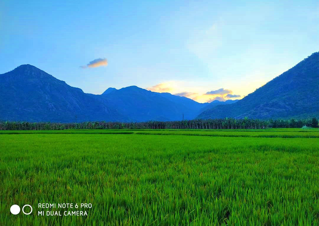

imported>Azhagiapandiapuram No edit summary |
No edit summary |
||
| Line 1: | Line 1: | ||
{{Short description|Neighbourhood in Kanyakumari district, Tamil Nadu, India}} | |||
{{More citations needed|date=April 2021}}{{Use dmy dates|date=December 2018}} | {{More citations needed|date=April 2021}}{{Use dmy dates|date=December 2018}} | ||
{{Use Indian English|date=December 2018}} | {{Use Indian English|date=December 2018}} | ||
{{Infobox settlement | {{Infobox settlement | ||
| name | | name = Azhagiapandiapuram | ||
| other_name | | other_name = Athiyanur | ||
| nickname | | nickname = Azhagai | ||
| settlement_type | | settlement_type = Village | ||
| image_skyline | | image_skyline = Collage of Azhagiapandiapuram.jpg | ||
| image_alt | | image_alt = | ||
| image_caption | | image_caption = Nature of Azhagiapandiapuram | ||
| pushpin_map | | pushpin_map = India Tamil Nadu | ||
| pushpin_label_position | | pushpin_label_position = | ||
| pushpin_map_alt | | pushpin_map_alt = | ||
| pushpin_map_caption | | pushpin_map_caption = Azhagiyapandipuram, Tamil Nadu | ||
| coordinates | | coordinates = {{coord|8.308100|N|77.438600|E|display=inline,title}} | ||
| subdivision_type | | subdivision_type = [[Country]] | ||
| subdivision_name | | subdivision_name = {{flag|India}} | ||
| subdivision_type1 | | subdivision_type1 = [[States and territories of India|State]] | ||
| subdivision_name1 | | subdivision_name1 = [[Tamil Nadu]] | ||
| subdivision_type2 | | subdivision_type2 = [[List of districts of India|District]] | ||
| subdivision_name2 | | subdivision_name2 = [[Kanniyakumari district|Kanniyakumari]] | ||
| established_title | | established_title = <!-- Established --> | ||
| established_date | | established_date = | ||
| founder | | founder = | ||
| named_for | | named_for = beautiful land of Pandia Dynasty | ||
| government_type | | government_type = Town Panchayat | ||
| governing_body | | governing_body = Azhgiapandiapuram Town Panchayat | ||
| unit_pref | | unit_pref = Metric | ||
| area_footnotes | | area_footnotes = | ||
| area_rank | | area_rank = | ||
| area_total_km2 | | area_total_km2 = 10.24 | ||
| elevation_footnotes | | elevation_footnotes = | ||
| elevation_m | | elevation_m = 70 | ||
| population_total | | population_total = 12183 | ||
| population_as_of | | population_as_of = 2011 | ||
| population_rank | | population_rank = | ||
| population_density_km2 | | population_density_km2 = 1194.4 | ||
| population_demonym | | population_demonym = Azhaiyandrumkaran | ||
| population_footnotes | | population_footnotes = | ||
| demographics_type1 | | demographics_type1 = Languages | ||
| demographics1_title1 | | demographics1_title1 = Official | ||
| demographics1_info1 | | demographics1_info1 = [[Tamil language|Tamil]] | ||
| timezone1 | | timezone1 = [[Indian Standard Time|IST]] | ||
| utc_offset1 | | utc_offset1 = +5:30 | ||
| postal_code_type | | postal_code_type = <!-- [[Postal Index Number|629851]] --> | ||
| postal_code | | postal_code = 629851 | ||
| registration_plate | | registration_plate = TN - 74 | ||
| website | | website = [https://www.townpanchayat.in/azhagiapandipuram townpanchayat.in/azhagiapandipuram] | ||
| footnotes | | footnotes = | ||
| official_name | | official_name = Azhagiapandiapuram | ||
| anthem = Jana gana Mana | |||
| leader_name = [[Narendra Modi]] | |||
| anthem | | leader_title = [[Prime Minister of India|Prime minister]] | ||
| leader_name | | subdivision_type3 = [[List of revenue divisions of Kanyakumari|Revenue division]] | ||
| leader_title | | subdivision_name3 = [[Nagercoil]] | ||
| subdivision_type3 | | subdivision_type4 = [[list of Tehsil|Tehsil]] | ||
| subdivision_name3 | | subdivision_name4 = [[Thovalai]] | ||
| subdivision_type4 | | subdivision_type5 = [[list of Revenue block|Revenue block]] | ||
| subdivision_name4 | | subdivision_name5 = Azhagiapandiapuram | ||
| subdivision_type5 | | elevation_min_m = 36 | ||
| subdivision_name5 | | elevation_max_m = 253 | ||
| elevation_min_m | | motto = Satyameva Jayate | ||
| elevation_max_m | | elevation_max_point = [[Panchagiri Peak]] | ||
| motto | |||
| elevation_max_point | |||
}} | }} | ||
| Line 69: | Line 68: | ||
== Location and Significance == | == Location and Significance == | ||
[[File:Azhagiapandiapuram.jpg|thumb| | [[File:Azhagiapandiapuram.jpg|thumb|Azhagiapandiapuram village]] | ||
The town spans an area of around 10.24 km<sup>2</sup> with Ettamadai, Kesavanputhoor, Melkarai, Perunthalaikadu, Kurathiyarai, Thomaiyarpuram and Palkulam as its sub-villages. The places situated in the vicinity of the town include Asambu Reserve Forest to the North, Derisanamcope and [[Thittuvilai]] to the south, and Kadukkarai and Kattuputhoor to the East, Chiramadam to Southwest, Gnalam to west and [[Arumanallur]] to Northwest. | The town spans an area of around 10.24 km<sup>2</sup> with [[Ettimadai|Ettamadai]], Kesavanputhoor, Melkarai, Perunthalaikadu, Kurathiyarai, Thomaiyarpuram and Palkulam as its sub-villages. The places situated in the vicinity of the town include Asambu Reserve Forest to the North, Derisanamcope and [[Thittuvilai]] to the south, and Kadukkarai and Kattuputhoor to the East, Chiramadam to Southwest, Gnalam to west and [[Arumanallur]] to Northwest. | ||
Azhagiapandiapuram is located 70 km Southeast of the [[Thiruvananthapuram|Trivandrum]] Metropolitan Region and 15 km to the North of [[Nagercoil]] the nearest city. Azhagiapandiapuram is 32 km away from the commercial towns of [[Marthandam]] and it is 35 km to the Northwest of Tourism hub [[Kanyakumari]]. | Azhagiapandiapuram is located 70 km Southeast of the [[Thiruvananthapuram|Trivandrum]] Metropolitan Region and 15 km to the North of [[Nagercoil]] the nearest city. Azhagiapandiapuram is 32 km away from the commercial towns of [[Marthandam]] and it is 35 km to the Northwest of Tourism hub [[Kanyakumari]]. | ||
==Demographics== | ==Demographics== | ||
[[File:Azhagiapandipuram-senthil-anand.jpg|thumb| | [[File:Azhagiapandipuram-senthil-anand.jpg|thumb|left|Azhagiapandiapuram]] | ||
{{As of| | {{As of|2011|lc=y}} India [[census]],<ref>{{cite web|url=http://www.censusindia.net/results/town.php?stad=A&state5=999|archiveurl=https://web.archive.org/web/20040616075334/http://www.censusindia.net/results/town.php?stad=A&state5=999|archivedate=2004-06-16|title= Census of India 2001: Data from the 2001 Census, including cities, villages and towns (Provisional)|accessdate=2008-11-01|publisher= Census Commission of India}}</ref> Azhagiapandiapuram had a population of 11,392. Males constitute 50% of the population and females 50% in which female population is just more than male population. Azhagiapandiapuram has an average [[Literacy in India|literacy]] rate of 83.71%, higher than the national average of 59.5%; with male literacy of 85.02% and female literacy of 82.40%. [[Scheduled Castes and Scheduled Tribes]] accounted for 4.50% and 0.15% of the population respectively. The town had a total of 3146 households. | ||
== History == | == History == | ||
The Ay clan was one of the major hill-chiefs of early historic south India.<ref name="Sreedhara Menon 2007">{{Cite book|last=Sreedhara Menon|first=A. | The Ay clan was one of the major hill-chiefs of early historic south India.<ref name="Sreedhara Menon 2007">{{Cite book|last=Sreedhara Menon|first=A.|title=A survey of Kerala history|date=2007|publisher=D C Books|isbn=978-81-264-1578-6|location=Kerala State, India|oclc=426093919}}</ref>{{page needed|date=August 2021}} Members of the Ay family – of the Podiyil Hills (the Aykudi) – were related to the early historic [[Chera dynasty|Cheras]] of central Kerala.{{citation needed|date=May 2021}} Towards the close of the early historic period, [[Pandyan dynasty|Pandya]] supremacy might have extended to the Ay territory (through it is likely that the Ay gained their independence during the [[Kalabhra dynasty|Kalabhra]] period). | ||
A number of Ay chiefs such as Andiran, Titiyan and Atiyan are mentioned in the early Tamil poems.{{citation needed|date=May 2021}} | A number of Ay chiefs such as Andiran, Titiyan and Atiyan are mentioned in the early Tamil poems.{{citation needed|date=May 2021}} | ||
| Line 89: | Line 88: | ||
== Etymology == | == Etymology == | ||
The name Azhagiapandiapuram is derived from the name of the Pandya chieftain Azhagiapandian, who ruled this region in the sangam period. | The name Azhagiapandiapuram is derived from the name of the [[Pandya dynasty|Pandya]] chieftain Azhagiapandian, who ruled this region in the sangam period. | ||
== Administration == | == Administration == | ||
[[File:Panchayatoffice.jpg|thumb| | [[File:Panchayatoffice.jpg|thumb|Panchayat office]] | ||
Azhagiapandiapuram is a town panchayat located in Kanyakumari district. It has 15 wards in the panchayat. It comes under Bhoothapandy Police limit of Nagercoil subdivision. It has forest range office, which is one of the five [[Forest range officer|forest range offices]] in Kanyakumari district.<ref name="Rev Adm">{{Cite web|title=Revenue Administration |publisher=Kanniyakumari District, Government of TamilNadu, India |url=https://kanniyakumari.nic.in/revenue-administration/ |access-date=2021-04-26}}</ref> | Azhagiapandiapuram is a town panchayat located in Kanyakumari district. It has 15 wards in the panchayat. It comes under Bhoothapandy Police limit of Nagercoil subdivision. It has forest range office, which is one of the five [[Forest range officer|forest range offices]] in Kanyakumari district.<ref name="Rev Adm">{{Cite web|title=Revenue Administration |publisher=Kanniyakumari District, Government of TamilNadu, India |url=https://kanniyakumari.nic.in/revenue-administration/ |access-date=2021-04-26}}</ref> | ||
== Areas of interest == | |||
== | Ettamadai is a trade centre in Azhagiyapandipuram town panchayat. Holy family church in Ettamadai is guarded by a hill and the hills has views from the top. Ulakai aruvi(Ulakkai falls) is another tourist spot. Azhgiyapandipuram village is surrounded by [[Western Ghats|Western ghats]] on all sides except south. | ||
== List of villages == | == List of villages == | ||
Latest revision as of 23:38, 16 August 2025
 | This article needs additional citations for verification. (April 2021) |
Azhagiapandiapuram
Athiyanur | |
|---|---|
Village | |
| Azhagiapandiapuram | |
 Nature of Azhagiapandiapuram | |
| Nickname: Azhagai | |
| Motto: Satyameva Jayate | |
| Anthem: Jana gana Mana | |
  Azhagiapandiapuram Azhagiyapandipuram, Tamil Nadu | |
| Coordinates: 8°18′29″N 77°26′19″E / 8.308100°N 77.438600°E | |
| Country |  India India |
| State | Tamil Nadu |
| District | Kanniyakumari |
| Revenue division | Nagercoil |
| Tehsil | Thovalai |
| Revenue block | Azhagiapandiapuram |
| Named for | beautiful land of Pandia Dynasty |
| Government | |
| • Type | Town Panchayat |
| • Body | Azhgiapandiapuram Town Panchayat |
| • Prime minister | Narendra Modi |
| Area | |
| • Total | 10.24 km2 (3.95 sq mi) |
| Elevation | 70 m (230 ft) |
| Highest elevation | 253 m (830 ft) |
| Lowest elevation | 36 m (118 ft) |
| Population (2011) | |
| • Total | 12,183 |
| • Density | 1,194.4/km2 (3,093/sq mi) |
| Demonym | Azhaiyandrumkaran |
| Languages | |
| • Official | Tamil |
| Time zone | UTC+5:30 (IST) |
| Vehicle registration | TN - 74 |
| Website | townpanchayat.in/azhagiapandipuram |
Azhagiapandiapuram is a second grade town panchayat in Kanniyakumari district in the state of Tamil Nadu, India. It is located at the centre of Pazhayar valley. It is one of the four town panchayat's in Thovalai taluk.[1]
Location and Significance[edit | edit source]

The town spans an area of around 10.24 km2 with Ettamadai, Kesavanputhoor, Melkarai, Perunthalaikadu, Kurathiyarai, Thomaiyarpuram and Palkulam as its sub-villages. The places situated in the vicinity of the town include Asambu Reserve Forest to the North, Derisanamcope and Thittuvilai to the south, and Kadukkarai and Kattuputhoor to the East, Chiramadam to Southwest, Gnalam to west and Arumanallur to Northwest.
Azhagiapandiapuram is located 70 km Southeast of the Trivandrum Metropolitan Region and 15 km to the North of Nagercoil the nearest city. Azhagiapandiapuram is 32 km away from the commercial towns of Marthandam and it is 35 km to the Northwest of Tourism hub Kanyakumari.
Demographics[edit | edit source]

as of 2011[update] India census,[2] Azhagiapandiapuram had a population of 11,392. Males constitute 50% of the population and females 50% in which female population is just more than male population. Azhagiapandiapuram has an average literacy rate of 83.71%, higher than the national average of 59.5%; with male literacy of 85.02% and female literacy of 82.40%. Scheduled Castes and Scheduled Tribes accounted for 4.50% and 0.15% of the population respectively. The town had a total of 3146 households.
History[edit | edit source]
The Ay clan was one of the major hill-chiefs of early historic south India.[3][page needed] Members of the Ay family – of the Podiyil Hills (the Aykudi) – were related to the early historic Cheras of central Kerala.[citation needed] Towards the close of the early historic period, Pandya supremacy might have extended to the Ay territory (through it is likely that the Ay gained their independence during the Kalabhra period).
A number of Ay chiefs such as Andiran, Titiyan and Atiyan are mentioned in the early Tamil poems.[citation needed]
- Ay Andiran is praised by early Tamil poets such as Mudamochiyar, Odakizhar, and Kiranar in Purananuru[citation needed] He is mentioned in the Purananuru as the "Lord of Podiyil Mala" in southern Western Ghats. He is said to have defeated the Kongu chiefs and pursued them to the Arabian Sea. He was an elder contemporary of the Chera chief Antuvan Cheral.[3][page needed]
- Ay Titiyan (the Podiyil Chelvan) is praised by authors Paranar and Bhuta Pandya (the Pandya chief) in Akananuru. It seems that Ay Titiyan was a vassal of the Pandya ruler Bhuta Pandya.[citation needed][3][page needed]
- Ay Atiyan, successor to Ay Titiyan, is mentioned by authors Paranar and Madurai Kanakkayanar in Akananuru. Paranar and Kanakkayanar also mention Podiyil Mala, the Ay base, as the property of Pachupun Pandya (Azhakiya Pandya), the successor to Bhuta Pandya.[citation needed]
- An Ay ruler took part in the famous battle of Talai-yalankanam, in which the Pandya chief Nedum Chezhiyan defeated several of his enemies.[3][page needed]
Etymology[edit | edit source]
The name Azhagiapandiapuram is derived from the name of the Pandya chieftain Azhagiapandian, who ruled this region in the sangam period.
Administration[edit | edit source]

Azhagiapandiapuram is a town panchayat located in Kanyakumari district. It has 15 wards in the panchayat. It comes under Bhoothapandy Police limit of Nagercoil subdivision. It has forest range office, which is one of the five forest range offices in Kanyakumari district.[4]
Areas of interest[edit | edit source]
Ettamadai is a trade centre in Azhagiyapandipuram town panchayat. Holy family church in Ettamadai is guarded by a hill and the hills has views from the top. Ulakai aruvi(Ulakkai falls) is another tourist spot. Azhgiyapandipuram village is surrounded by Western ghats on all sides except south.
List of villages[edit | edit source]
Azhagiapandiapuram firka is one of the 18 firkas in Kaniyakumari district and it is one of the 3 firkas in Thovalai taluk. List of villages comes under Azhagiapandiapuram firka.[4]
- Derisanamcope
- Gnalam
- Arumanallur
- Thadikkarankonam
- Kattuputhur
- Ananthapuram (Kadukkarai)
- Thidal
Festivals[edit | edit source]
There are at least eleven temples in the village. The major festivals celebrated are:
| PLACE OF WORSHIP | FESTIVAL NAME | DAYS | MONTH |
|---|---|---|---|
| Arulmigu Veeravanangai Amman Temple[5] | Kalivoottu Thiruvizha | 3 Days | March |
| Holy Family Church | Thirukudumba Thiruvizha | 10 Days | January |
| Kasi Vishwanathar Temple | Theppa Thiruvizha | 5 Days | January |
References[edit | edit source]
- ↑ Prethesa Mercy, S; Selva Smiley, C (1 December 2019). "A Study on Economic Conditions of Jasmine Flower Cultivators at Thovalai Village in Thovalai Taluk of Kanyakumari District". Shanlax International Journal of Economics. 8 (1): 17–20. doi:10.34293/economics.v8i1.864. ISSN 2582-0192.
- ↑ "Census of India 2001: Data from the 2001 Census, including cities, villages and towns (Provisional)". Census Commission of India. Archived from the original on 16 June 2004. Retrieved 1 November 2008.
- ↑ 3.0 3.1 3.2 3.3 Sreedhara Menon, A. (2007). A survey of Kerala history. Kerala State, India: D C Books. ISBN 978-81-264-1578-6. OCLC 426093919.
- ↑ 4.0 4.1 "Revenue Administration". Kanniyakumari District, Government of TamilNadu, India. Retrieved 26 April 2021.
- ↑ "Azhagiapandipuram Town Panchayat-". www.townpanchayat.in. Retrieved 26 April 2021.