




→See also: I am native of kailaras . |
Enhanced article with new information |
||
| Line 1: | Line 1: | ||
{{Use dmy dates|date=February 2019}} | {{Use dmy dates|date=February 2019}} | ||
{{Use Indian English|date=February 2019}} | {{Use Indian English|date=February 2019}} | ||
{{Infobox settlement | {{Infobox settlement | ||
| name | | name = Kailaras | ||
| native_name | | native_name = कैलारस | ||
| native_name_lang | | native_name_lang = | ||
| other_name | | other_name = | ||
| nickname | | nickname = | ||
| settlement_type | | settlement_type = Town (Urban municipality) | ||
| image_skyline | | image_skyline = Kailaras view.jpg | ||
| image_alt | | image_alt = | ||
| image_caption | | image_caption = | ||
| pushpin_map | | pushpin_map = India Madhya Pradesh#India3 | ||
| pushpin_label_position | | pushpin_label_position = right | ||
| pushpin_map_alt | | pushpin_map_alt = | ||
| pushpin_map_caption | | pushpin_map_caption = Location in Madhya Pradesh, India | ||
| coordinates | | coordinates = {{coord|26.32|N|77.62|E|display=inline,title}} | ||
| subdivision_type | | subdivision_type = Country | ||
| subdivision_name | | subdivision_name = {{flag|India}} | ||
| subdivision_type1 | | subdivision_type1 = [[States and territories of India|State]] | ||
| subdivision_name1 | | subdivision_name1 = [[Madhya Pradesh]] | ||
| subdivision_type2 | | subdivision_type2 = [[List of districts of India|District]] | ||
| subdivision_name2 | | subdivision_name2 = [[Morena district|Morena]] | ||
| established_title | | established_title = <!-- Established --> | ||
| established_date | | established_date = | ||
| founder | | founder = | ||
| named_for | | named_for = | ||
| government_type | | government_type = Nagar panchayat | ||
| governing_body | | governing_body = | ||
| unit_pref | | unit_pref = Metric | ||
| area_footnotes | | area_footnotes = | ||
| area_rank | | area_rank = | ||
| area_total_km2 | | area_total_km2 = | ||
| elevation_footnotes | | elevation_footnotes = | ||
| elevation_m | | elevation_m = 190 | ||
| population_total | | population_total = 13,936 male<br> | ||
11,984 female | 11,984 female<br> | ||
25,920 total | 25,920 total | ||
| population_as_of | | population_as_of = 2011 | ||
| population_rank | | population_rank = | ||
| population_density_km2 | | population_density_km2 = auto | ||
| population_demonym | | population_demonym = | ||
| population_footnotes | | population_footnotes = | ||
| demographics_type1 | | demographics_type1 = Languages | ||
| demographics1_title1 | | demographics1_title1 = Official | ||
| demographics1_info1 | | demographics1_info1 = [[Hindi language|Hindi]] | ||
| timezone1 | | timezone1 = [[Indian Standard Time|IST]] | ||
| utc_offset1 | | utc_offset1 = +5:30 | ||
| postal_code_type | | postal_code_type = [[Postal Index Number|PIN]] | ||
| postal_code | | postal_code = 476224 | ||
| registration_plate | | registration_plate = [[Vehicle registration plates of India|MP]]-06 | ||
| website | | website = | ||
| iso_code | | iso_code = [[ISO 3166-2:IN|IN-MP]] | ||
| footnotes | | footnotes = | ||
| official_name | | official_name = | ||
}} | }} | ||
'''Kailaras''' is a town and a [[nagar panchayat]] in [[Morena district]] in the [[India]]n [[States and territories of India|state]] of [[Madhya Pradesh]].The name of the town is related to Kailash mountain due to the Temple of God Shankar,Alopi Shankar Temple which is situated on a hill 490 meters above sea level. | '''Kailaras''' is a town and a [[nagar panchayat]] in [[Morena district]] in the [[India]]n [[States and territories of India|state]] of [[Madhya Pradesh]]. The name of the town is related to [[Mount Kailash|Kailash]] mountain due to the Temple of God Shankar, Alopi Shankar Temple which is situated on a hill 490 meters above sea level. | ||
Kailaras is located on the bank of [[Kwari River|Kwari]] river. The Alopi Shankar temple located on the hill is an attraction point for many devotees who visit the city on the occasion of [[Mahashivratri]]. | |||
==Geography== | ==Geography== | ||
[[File:Temple alopi shankar.jpg|thumb|187x187px|Alopi shankar temple]] | |||
Kailaras is located at | Kailaras is located at | ||
{{Coord|26.32|N|77.62|E|}}. | {{Coord|26.32|N|77.62|E|}}.<ref>[http://www.fallingrain.com/world/IN/35/Kailaras.html Falling Rain Genomics, Inc - Kailaras]</ref> It has an average elevation of 190&nbsp;metres (623&nbsp;feet). The Kwari river passes through the middle of Kailaras. The Sone and [[Chambal River|Chambal]] rivers run close to the town. There are several holy temples around Kailaras. | ||
==Demographics== | ==Demographics== | ||
According to the Indian [[census]], | According to the Indian [[census]],<ref>{{cite web|url=http://www.censusindia.net/results/town.php?stad=A&state5=999|archiveurl=https://web.archive.org/web/20040616075334/http://www.censusindia.net/results/town.php?stad=A&state5=999|archivedate=2004-06-16|title= Census of India 2001: Data from the 2001 Census, including cities, villages and towns (Provisional)|accessdate=2008-11-01|publisher= Census Commission of India}}</ref> | ||
in 2011 Kailaras had a population of 25,920. Males constituted 54% of the population and females 46%. Kailaras had an average literacy rate of 73.9%, higher than the national average of 59.5%: male literacy was 73.9% and female literacy was 58.8%. | in 2011 Kailaras had a population of 25,920. Males constituted 54% of the population and females 46%. Kailaras had an average literacy rate of 73.9%, higher than the national average of 59.5%: male literacy was 73.9% and female literacy was 58.8%. | ||
=== | == Transport == | ||
=== Road === | |||
Kailaras is well connected with other major cities via road. [[National Highway 552 (India)|National highway NH-552]] passes through the town which connects it to [[Sheopur]] in west and [[Bhind district|Bhind]] in east. It is 84 kilometers from [[Gwalior]]. It is connected to [[Shivpuri]] via state highway which passes through Pahargarh. | |||
It has a dedicated bus stand which provides the transport services to people through private bus companies. | |||
[[File:Kailaras station.jpg|thumb|173x173px|Railway station (KQS)]] | |||
=== Rail === | |||
'''Kailaras railway station (KQS)''' of the [[North Central Railway zone]] serves the city. Kailaras has been connected via the historical [[Gwalior Light Railway]] line built during [[Gwalior State]]. It has now been converted to broad gauge line which connects it to Gwalior. Three trains run daily from Kailaras to Gwalior which cover distance of 71 kilometers. An extension of this railway line is in the construction phase which on completion will connect it to [[Kota, Rajasthan|Kota]] in Rajasthan. | |||
=== Air === | |||
The nearest airport to the city is [[Gwalior Airport]] which is 94 km away. | |||
== Governance and administration == | |||
=== Governance & politics === | |||
Kailaras is governed by a municipal body whose elections are conducted every 5 years. It has more than a dozen wards which elect their own [[Parshad]]. | |||
=== Revenue department === | |||
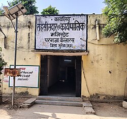
[[File:Tehsildar office.jpg|thumb|Tehsildar office|192x192px]] | |||
Kailaras has a unit of revenue department which is headed by a [[Tehsildar]] which deals with the matter related to land records. | |||
=== Police === | |||
Kailaras has a police station serving the city of Kailaras and the nearby villages. | |||
== Economy == | |||
Kailaras was famously known for its co-operative sugar factory which had a significant impact on the economy of the city. The majority of Kailaras’ population is self employed. Major banks like the [[State Bank of India]], [[HDFC Bank]], and the [[Central Bank of India]] have their branches along with some state level banks. | |||
[[File:Doordarshan relay kendra.jpg|thumb|193x193px|Doordarshan relay center]] | |||
The [[Doordarshan]] relay kendra of [[Prasar Bharati]] has its office in the city. The city has a large complex called ''Anaaj Mandi'' which is used for the purchasing of food grains from the farmers. Many warehouses are also located near the city. Kailaras has one post office. | |||
== | == Public amenities == | ||
[[ | === Healthcare === | ||
[[File:Government hospital kailaras.jpg|thumb|Government Hospital |187x187px]] | |||
[[ | Kailaras has a government health center which provides primary healthcare services to its residents. Along with this about a dozen doctors are also in the medical practice. Kailaras has many medical stores and pathology labs serving the people of nearby villages as well. | ||
=== Education === | |||
[[File:Government school kailaras.jpg|thumb|Government school|171x171px]] | |||
Kailaras has many private run schools along with the government schools. It has a few colleges for higher education which provide BA & BSc courses. It has many coaching centers which provide education to the students of nearby villages as well. | |||
=== Parks === | |||
The Deendayal Upadhyay park located is the only public park in the city open very often. | |||
==References== | ==References== | ||
<references/> | |||
==External links== | |||
{{commons category|Kailaras}} | |||
{{Chambal Division}} | {{Chambal Division}} | ||
[[Category:Cities and towns in Morena district]] | [[Category:Cities and towns in Morena district]] | ||
[[Category:Morena]] | [[Category:Morena, Madhya Pradesh]] | ||
{{MadhyaPradesh-geo-stub}} | {{MadhyaPradesh-geo-stub}} | ||
Revision as of 23:58, 10 May 2025
Kailaras
कैलारस | |
|---|---|
Town (Urban municipality) | |
 | |
  Kailaras Location in Madhya Pradesh, India  Kailaras Kailaras (India) | |
| Coordinates: 26°19′N 77°37′E / 26.32°N 77.62°E | |
| Country |  India India |
| State | Madhya Pradesh |
| District | Morena |
| Government | |
| • Type | Nagar panchayat |
| Elevation | 190 m (620 ft) |
| Population (2011) | |
| • Total | 13,936 male<br>
11,984 female<br> 25,920 total |
| Languages | |
| • Official | Hindi |
| Time zone | UTC+5:30 (IST) |
| PIN | 476224 |
| ISO 3166 code | IN-MP |
| Vehicle registration | MP-06 |
Kailaras is a town and a nagar panchayat in Morena district in the Indian state of Madhya Pradesh. The name of the town is related to Kailash mountain due to the Temple of God Shankar, Alopi Shankar Temple which is situated on a hill 490 meters above sea level.
Kailaras is located on the bank of Kwari river. The Alopi Shankar temple located on the hill is an attraction point for many devotees who visit the city on the occasion of Mahashivratri.
Geography

Kailaras is located at 26°19′N 77°37′E / 26.32°N 77.62°E.<ref>Falling Rain Genomics, Inc - Kailaras</ref> It has an average elevation of 190 metres (623 feet). The Kwari river passes through the middle of Kailaras. The Sone and Chambal rivers run close to the town. There are several holy temples around Kailaras.
Demographics
According to the Indian census,<ref>"Census of India 2001: Data from the 2001 Census, including cities, villages and towns (Provisional)". Census Commission of India. Archived from the original on 16 June 2004. Retrieved 1 November 2008.</ref> in 2011 Kailaras had a population of 25,920. Males constituted 54% of the population and females 46%. Kailaras had an average literacy rate of 73.9%, higher than the national average of 59.5%: male literacy was 73.9% and female literacy was 58.8%.
Transport
Road
Kailaras is well connected with other major cities via road. National highway NH-552 passes through the town which connects it to Sheopur in west and Bhind in east. It is 84 kilometers from Gwalior. It is connected to Shivpuri via state highway which passes through Pahargarh.
It has a dedicated bus stand which provides the transport services to people through private bus companies.

Rail
Kailaras railway station (KQS) of the North Central Railway zone serves the city. Kailaras has been connected via the historical Gwalior Light Railway line built during Gwalior State. It has now been converted to broad gauge line which connects it to Gwalior. Three trains run daily from Kailaras to Gwalior which cover distance of 71 kilometers. An extension of this railway line is in the construction phase which on completion will connect it to Kota in Rajasthan.
Air
The nearest airport to the city is Gwalior Airport which is 94 km away.
Governance and administration
Governance & politics
Kailaras is governed by a municipal body whose elections are conducted every 5 years. It has more than a dozen wards which elect their own Parshad.
Revenue department

Kailaras has a unit of revenue department which is headed by a Tehsildar which deals with the matter related to land records.
Police
Kailaras has a police station serving the city of Kailaras and the nearby villages.
Economy
Kailaras was famously known for its co-operative sugar factory which had a significant impact on the economy of the city. The majority of Kailaras’ population is self employed. Major banks like the State Bank of India, HDFC Bank, and the Central Bank of India have their branches along with some state level banks.

The Doordarshan relay kendra of Prasar Bharati has its office in the city. The city has a large complex called Anaaj Mandi which is used for the purchasing of food grains from the farmers. Many warehouses are also located near the city. Kailaras has one post office.
Public amenities
Healthcare

Kailaras has a government health center which provides primary healthcare services to its residents. Along with this about a dozen doctors are also in the medical practice. Kailaras has many medical stores and pathology labs serving the people of nearby villages as well.
Education

Kailaras has many private run schools along with the government schools. It has a few colleges for higher education which provide BA & BSc courses. It has many coaching centers which provide education to the students of nearby villages as well.
Parks
The Deendayal Upadhyay park located is the only public park in the city open very often.
References
<references/>
External links
 | This article related to a location in Madhya Pradesh is a stub. You can help Bharatpedia by expanding it. |