
No edit summary |
WikiDwarfBOT (talk | contribs) Cleanup: Source modification. |
||
| Line 2: | Line 2: | ||
{{Use dmy dates|date=February 2017}} | {{Use dmy dates|date=February 2017}} | ||
{{Infobox settlement | {{Infobox settlement | ||
| name = Kalpa | | name = Kalpa | ||
| native_name = | | native_name = | ||
| native_name_lang = | | native_name_lang = | ||
| Line 17: | Line 17: | ||
| coordinates = {{coord|31.53|N|78.25|E|display=inline,title}} | | coordinates = {{coord|31.53|N|78.25|E|display=inline,title}} | ||
| subdivision_type = [[List of sovereign states|Country]] | | subdivision_type = [[List of sovereign states|Country]] | ||
| subdivision_name = India | | subdivision_name = {{flag|India}} | ||
| subdivision_type1 = [[States and territories of India|State]] | | subdivision_type1 = [[States and territories of India|State]] | ||
| subdivision_name1 = [[Himachal Pradesh]] | | subdivision_name1 = [[Himachal Pradesh]] | ||
| Line 47: | Line 47: | ||
| postal_code_type = [[Postal Index Number|PIN]] | | postal_code_type = [[Postal Index Number|PIN]] | ||
| postal_code = 172108 | | postal_code = 172108 | ||
| registration_plate = | | registration_plate = HP-25 | ||
| website = | | website = | ||
| footnotes = | | footnotes = | ||
}} | }} | ||
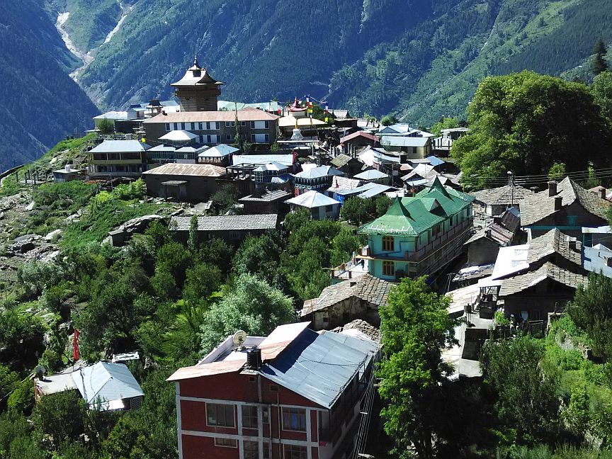
'''Kalpa''' is a small village | '''Kalpa''' is a small village in the [[Sutlej]] river valley, above [[Reckong Peo]] in the [[Kinnaur district]] of [[Himachal Pradesh]], [[Northern India]], in the Indian [[Himalaya]]. The region is inhabited by the [[Kinnaur]]i people and is known for its apple orchards, as apples are a major cash-crop for the region. The local [[Kinnauri]] follow a [[syncretism]] of [[Hinduism]] and [[Buddhism]], and many temples in Kalpa are dedicated to both Hindu and Buddhist gods and goddesses. The average literacy rate of Kalpa is around 83.75%. India's first ever voter, [[Shyam Saran Negi]], also belongs to Kalpa.<ref>{{cite web|url=http://indianexpress.com/article/india/politics/indias-first-voter-shyam-saran-negi-casts-his-vote-at-kalpa/|title=India’s first voter Shyam Saran Negi casts his vote at Kalpa}}</ref> | ||
==Geography== | ==Geography== | ||
Kalpa is at {{coord|31.53|N|78.25|E|}}.<ref>[http://www.fallingrain.com/world/IN/11/Kalpa.html Falling Rain Genomics, Inc - Kalpa]</ref> It has an average elevation of 2,960 metres (9,711 feet) | [[File:Kinner Kailash Mountain Range (edited).jpg|thumb|The Kinnaur Kailash massif towers over the town of Kalpa]] | ||
Kalpa is at {{coord|31.53|N|78.25|E|}}.<ref>[http://www.fallingrain.com/world/IN/11/Kalpa.html Falling Rain Genomics, Inc - Kalpa]</ref> It has an average elevation of 2,960 metres (9,711 feet) and is located 265 kilometres (165 mi) beyond [[Shimla]] on the NH-5 in [[Kinnaur district]]. It sits at the base of the snow-capped [[Kinnaur Kailash]] ranges. The [[Shivling]] peaks rise up to 6,000 m (20,000 feet). Kalpa is nestled among apple orchards, pine-nut forests, and the stately [[Cedrus deodara|deodhar]]s. | |||
==Overview== | ==Overview== | ||
[[File:Kalpa 2015.jpg|thumb|left|Kalpa as of June 2015]] | [[File:Kalpa 2015.jpg|thumb|left|Kalpa as of June 2015]] | ||
Kalpa is a village with a history of ancient temples. The [[Sutlej River]] below | Kalpa was known as a Chini village during the colonial and pre colonial period. it was tehsil headquarter during colonial times and later became district headquarter of Kinnaur before it was shifted to Reckong Peo. current Kalpa is a village with a history of ancient temples. The [[Sutlej River]] below runs through deep gorges, and the winding mountain road is bordered by [[chilgoza]] forests. The serenity of this sleepy hamlet was not often visited by foreigners until recently, but there are still relatively few visitors. There are now more than five places to stay in Kalpa and more below in [[Reckong Peo]] where travelers must stop to get their [[Foreigners (Protected Areas) Order 1958 (India)|inner line permits]] to continue upwards to the [[Spiti Valley]], which is a small ancient part of what used to be [[Tibet]]. Also visible from here is the sacred Shivling rock on the [[Kailash]] mountain that changes its color at different points in the day. | ||
In Episode 5 of [[Ice Road Truckers#IRT: Deadliest Roads - Season 1: Himalayas]] Lisa Kelly and Rick Yemm delivered two images (one each) (well [[dunnage|packed]] with [[sandbag]]s and sand and straw) of the goddess [[Kali]] (shown as treading on her husband [[Shiva]]) along a frightful mountain road hacked out of cliffsides to a temple at Kalpa. | In Episode 5 of [[Ice Road Truckers#IRT: Deadliest Roads - Season 1: Himalayas]] Lisa Kelly and Rick Yemm delivered two images (one each) (well [[dunnage|packed]] with [[sandbag]]s and sand and straw) of the goddess [[Kali]] (shown as treading on her husband [[Shiva]]) along a frightful mountain road hacked out of cliffsides to a temple at Kalpa. | ||
==Demography== | ==Demography== | ||
[[File:Stupa in Kalpa, Himachal Pradesh.jpg|thumb|upright=0.7|Buddhist | [[File:Stupa in Kalpa, Himachal Pradesh.jpg|thumb|upright=0.7|Buddhist stupa at Kalpa]] | ||
Kalpa has an average literacy rate of 83.75%. | Kalpa has an average literacy rate of 83.75%. | ||
| Line 78: | Line 79: | ||
==Agriculture== | ==Agriculture== | ||
The region is very famous for production of high-quality [[apple]]s and [[pinus gerardiana]], also known as chilghoza. All of tehsil Kalpa is apple growing area, the primary crop for residents of the area. Kalpa is surrounded by Deodar, apple, and [[pinus gerardiana]] chilghoza trees. | |||
==Climate== | ==Climate== | ||
All | All of Kalpa enjoys a temperate climate due to its high elevation, with long winters from October to May, and short summers from June to September. In winter, all the villages are covered by about 5–7 feet of snow, and the temperature can drop to as low as -20 °C. Warm clothing may be necessary even in the summer. | ||
{{Weather box | {{Weather box | ||
| Line 204: | Line 205: | ||
==Food habits== | ==Food habits== | ||
The staple | The staple foods are wheat, ogla, phafra, and barley, all local produce. Besides these, kankani, cheena, maize, chollair and bathu are also common. The principal pulses consumed are peas, black peas, mash and rajmash. The vegetables usually consumed are cabbage, turnips, peas, beans, pumpkin, potato, okra and tomato besides some locally available wild greens. Also popular is rice, which is imported from the plains. A salted tea in the morning and evening is very popular among the Kinnauris, usually taken along with sattu made of parched barley flour. People are non-vegetarian and eat goat and ram's meat. Alcoholic drinks in day-to-day life and also on ceremonial or festive occasions are quite common. Alcohol is distilled at the household level. It is made out of locally grown fruits like grapes, apple, and pears, as well as from barley. | ||
==Lifestyle== | ==Lifestyle== | ||
| Line 215: | Line 216: | ||
<gallery> | <gallery> | ||
File:Kalpa and Kailash.jpg|Kalpa and Kinnaur Kailash during monsoon weather | File:Kalpa and Kailash.jpg|Kalpa and Kinnaur Kailash during monsoon weather | ||
File:Inside of Kalpa Temple,Kinnaur.jpg|Wood work at main Entrance of Hindu Temple at Kalpa | File:Inside of Kalpa Temple,Kinnaur.jpg|Wood work at main Entrance of Hindu Temple at Kalpa | ||
File:Hindu Temple at Kalpa, Himachal Pradesh.jpg|Hindu Temple at Kalpa | File:Hindu Temple at Kalpa, Himachal Pradesh.jpg|Hindu Temple at Kalpa | ||
| Line 229: | Line 229: | ||
* [https://web.archive.org/web/20100519130630/http://www.elenas-vieques.com/ikinnaur.html Kalpa - Kinnaur - Indian Himalayas] | * [https://web.archive.org/web/20100519130630/http://www.elenas-vieques.com/ikinnaur.html Kalpa - Kinnaur - Indian Himalayas] | ||
* [http://www.trekearth.com/gallery/Asia/India/North/Himachal_Pradesh/Kalpa/ Photographs of Kalpa] | * [http://www.trekearth.com/gallery/Asia/India/North/Himachal_Pradesh/Kalpa/ Photographs of Kalpa] | ||
[[Category:Cities and towns in Kinnaur district]] | [[Category:Cities and towns in Kinnaur district]] | ||
[[Category:Tourism in Himachal Pradesh]] | [[Category:Tourism in Himachal Pradesh]] | ||
Latest revision as of 06:26, 22 July 2023
Kalpa | |
|---|---|
Village | |
.jpg) | |
  Kalpa Location in Himachal Pradesh, India  Kalpa Kalpa (India) | |
| Coordinates: 31°32′N 78°15′E / 31.53°N 78.25°E | |
| Country |  India India |
| State | Himachal Pradesh |
| District | Kinnaur |
| Elevation | 2,960 m (9,710 ft) |
| Languages | |
| • Official | Hindi |
| Time zone | UTC+5:30 (IST) |
| PIN | 172108 |
| Vehicle registration | HP-25 |
Kalpa is a small village in the Sutlej river valley, above Reckong Peo in the Kinnaur district of Himachal Pradesh, Northern India, in the Indian Himalaya. The region is inhabited by the Kinnauri people and is known for its apple orchards, as apples are a major cash-crop for the region. The local Kinnauri follow a syncretism of Hinduism and Buddhism, and many temples in Kalpa are dedicated to both Hindu and Buddhist gods and goddesses. The average literacy rate of Kalpa is around 83.75%. India's first ever voter, Shyam Saran Negi, also belongs to Kalpa.[1]
Geography[edit | edit source]
Kalpa is at 31°32′N 78°15′E / 31.53°N 78.25°E.[2] It has an average elevation of 2,960 metres (9,711 feet) and is located 265 kilometres (165 mi) beyond Shimla on the NH-5 in Kinnaur district. It sits at the base of the snow-capped Kinnaur Kailash ranges. The Shivling peaks rise up to 6,000 m (20,000 feet). Kalpa is nestled among apple orchards, pine-nut forests, and the stately deodhars.
Overview[edit | edit source]

Kalpa was known as a Chini village during the colonial and pre colonial period. it was tehsil headquarter during colonial times and later became district headquarter of Kinnaur before it was shifted to Reckong Peo. current Kalpa is a village with a history of ancient temples. The Sutlej River below runs through deep gorges, and the winding mountain road is bordered by chilgoza forests. The serenity of this sleepy hamlet was not often visited by foreigners until recently, but there are still relatively few visitors. There are now more than five places to stay in Kalpa and more below in Reckong Peo where travelers must stop to get their inner line permits to continue upwards to the Spiti Valley, which is a small ancient part of what used to be Tibet. Also visible from here is the sacred Shivling rock on the Kailash mountain that changes its color at different points in the day.
In Episode 5 of Ice Road Truckers#IRT: Deadliest Roads - Season 1: Himalayas Lisa Kelly and Rick Yemm delivered two images (one each) (well packed with sandbags and sand and straw) of the goddess Kali (shown as treading on her husband Shiva) along a frightful mountain road hacked out of cliffsides to a temple at Kalpa.
Demography[edit | edit source]
Kalpa has an average literacy rate of 83.75%.
Religion[edit | edit source]
Hinduism is the main religion in the district followed by Tibetan Buddhism. These two religions have undergone religious mixing, along with some indigenous shamanistic practices.
Places of interest[edit | edit source]
Reckong Peo : Located 260 km from Shimla, 7 km from Powari and 8 km from Kalpa. Reckong Peo is the headquarters of district Kinnaur.
Kothi Temple: Just 3 km from Reckong Peo. Kothi has a temple dedicated to the goddess Chandika Devi. Set against a backdrop of mountains and groves of the deodar the temple has an unusual architectural style and fine sculpture. An exquisite gold image of goddess is enshrined in sanctum.
The Chaka Meadows is an easy hike of 3-4 kilometres. The trail starts from a point on Kalpa - Roghi road. Chaka meadows ( alt. 3800 m) offers splendid views of the Kinnaur Kailash mountain range.[3]
Agriculture[edit | edit source]
The region is very famous for production of high-quality apples and pinus gerardiana, also known as chilghoza. All of tehsil Kalpa is apple growing area, the primary crop for residents of the area. Kalpa is surrounded by Deodar, apple, and pinus gerardiana chilghoza trees.
Climate[edit | edit source]
All of Kalpa enjoys a temperate climate due to its high elevation, with long winters from October to May, and short summers from June to September. In winter, all the villages are covered by about 5–7 feet of snow, and the temperature can drop to as low as -20 °C. Warm clothing may be necessary even in the summer.
| Climate data for Kalpa, Himachal Pradesh (1984–2010, extremes 1984–2011) | |||||||||||||
|---|---|---|---|---|---|---|---|---|---|---|---|---|---|
| Month | Jan | Feb | Mar | Apr | May | Jun | Jul | Aug | Sep | Oct | Nov | Dec | Year |
| Record high °C (°F) | 16.1 (61.0) |
18.1 (64.6) |
24.4 (75.9) |
25.2 (77.4) |
28.6 (83.5) |
30.7 (87.3) |
27.8 (82.0) |
28.3 (82.9) |
28.3 (82.9) |
24.6 (76.3) |
24.5 (76.1) |
19.0 (66.2) |
30.7 (87.3) |
| Average high °C (°F) | 5.2 (41.4) |
6.5 (43.7) |
11.1 (52.0) |
16.6 (61.9) |
20.4 (68.7) |
22.8 (73.0) |
22.7 (72.9) |
22.2 (72.0) |
21.0 (69.8) |
18.2 (64.8) |
14.3 (57.7) |
8.8 (47.8) |
15.8 (60.4) |
| Average low °C (°F) | −4.0 (24.8) |
−3.0 (26.6) |
0.3 (32.5) |
3.9 (39.0) |
6.8 (44.2) |
10.2 (50.4) |
12.8 (55.0) |
12.6 (54.7) |
9.3 (48.7) |
4.2 (39.6) |
1.2 (34.2) |
−1.5 (29.3) |
4.4 (39.9) |
| Record low °C (°F) | −15.4 (4.3) |
−11.0 (12.2) |
−8.2 (17.2) |
−3.5 (25.7) |
−0.5 (31.1) |
3.5 (38.3) |
6.0 (42.8) |
5.8 (42.4) |
3.0 (37.4) |
−3.6 (25.5) |
−5.5 (22.1) |
−8.6 (16.5) |
−15.4 (4.3) |
| Average rainfall mm (inches) | 139.6 (5.50) |
99.4 (3.91) |
197.7 (7.78) |
75.6 (2.98) |
67.6 (2.66) |
30.2 (1.19) |
46.8 (1.84) |
45.5 (1.79) |
63.5 (2.50) |
31.8 (1.25) |
27.9 (1.10) |
52.3 (2.06) |
878.0 (34.57) |
| Average rainy days | 5.9 | 6.8 | 8.2 | 5.7 | 5.5 | 2.5 | 4.8 | 5.2 | 4.7 | 1.8 | 1.4 | 3.4 | 55.7 |
| Average relative humidity (%) (at 17:30 IST) | 43 | 48 | 42 | 40 | 44 | 50 | 65 | 69 | 62 | 44 | 36 | 36 | 49 |
| Source: India Meteorological Department[4][5] | |||||||||||||
Food habits[edit | edit source]
The staple foods are wheat, ogla, phafra, and barley, all local produce. Besides these, kankani, cheena, maize, chollair and bathu are also common. The principal pulses consumed are peas, black peas, mash and rajmash. The vegetables usually consumed are cabbage, turnips, peas, beans, pumpkin, potato, okra and tomato besides some locally available wild greens. Also popular is rice, which is imported from the plains. A salted tea in the morning and evening is very popular among the Kinnauris, usually taken along with sattu made of parched barley flour. People are non-vegetarian and eat goat and ram's meat. Alcoholic drinks in day-to-day life and also on ceremonial or festive occasions are quite common. Alcohol is distilled at the household level. It is made out of locally grown fruits like grapes, apple, and pears, as well as from barley.
Lifestyle[edit | edit source]
Generally, Kinner houses have storerooms for keeping grain and dried fruits, and separate wooden grain-storage structures, called kathar. Pakpa, a piece of sheepskin or yakskin, is often placed on the khayarcha mat. Traditionally Kinners use utensils made of brass and bronze. Modern influences have included the introduction of Chinese crockery, and utensils made of stainless steel and aluminium. Clothes are mainly of wool. The thepang, a grey woollen cap with green velvet band is worn by the local people . The Tibetan chhuba, a long woollen coat which resembles an achkan, is worn as well, with a sleeveless woollen jacket. While men wear woollen churidhar pajamas, and tailored woollen shirts such as the chamn kurti, the women wrap themselves up in a dohru. The first wrap of the dohru is based on the back, with embroidered borders displayed throughout its length, which stretches to the heels. Darker shades of colours are preferred for the Dohru, although other coloured shawls may be worn, usually draped over the shoulders. A choli, another type of full sleeved blouse worn by women, may serve as a decorative lining as well. The Kinners are classified mainly into two castes: lower and upper caste. Again both of these categories are divided into sub classes. The caste system is more prevalent in the Lower and Middle Kinnaur regions
Gallery[edit | edit source]
-
Kalpa and Kinnaur Kailash during monsoon weather
-
Wood work at main Entrance of Hindu Temple at Kalpa
-
Hindu Temple at Kalpa
-
Kinnaur Kailash from Kalpa
-
Kinner Kailash Resort Kalpa
-
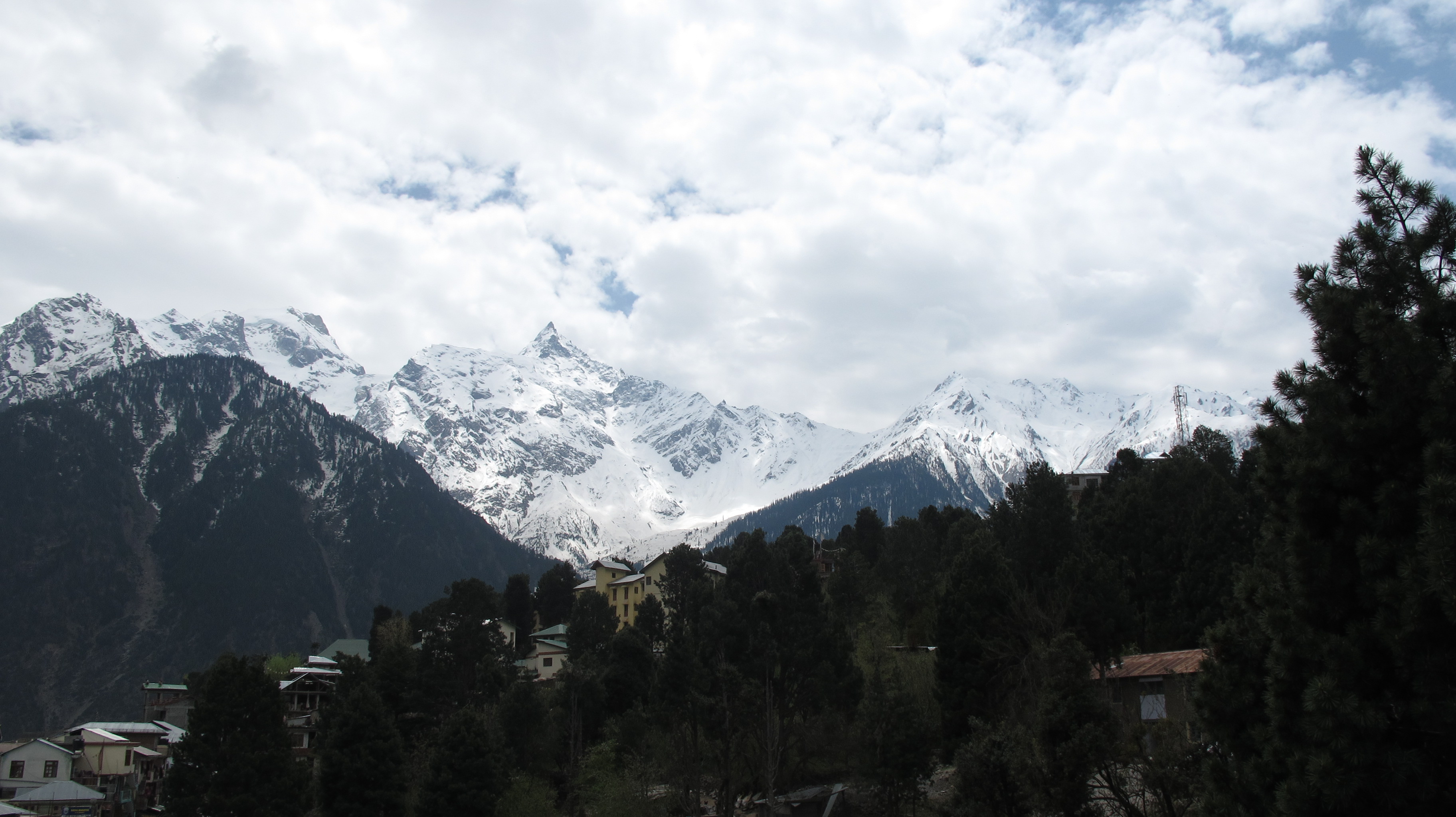 Kinner Kailash range form Kalpa

.jpg)


References[edit | edit source]
- ↑ "India's first voter Shyam Saran Negi casts his vote at Kalpa".
- ↑ Falling Rain Genomics, Inc - Kalpa
- ↑ "Chaka meadows hike". Raacho Trekkers.
- ↑ "Station: Kalpa Climatological Table 1981–2010" (PDF). Climatological Normals 1981–2010. India Meteorological Department. January 2015. pp. 381–382. Archived from the original (PDF) on 5 February 2020. Retrieved 15 February 2020.
- ↑ "Extremes of Temperature & Rainfall for Indian Stations (Up to 2012)" (PDF). India Meteorological Department. December 2016. p. M69. Archived from the original (PDF) on 5 February 2020. Retrieved 15 February 2020.