


>AnomieBOT m Dating maintenance tags: {{Cn}} |
robot: Update article (please report if you notice any mistake or error in this edit) |
||
| Line 1: | Line 1: | ||
{{Use dmy dates|date=September 2017}} | {{Use dmy dates|date=September 2017}} | ||
{{Use Indian English|date=September 2017}} | {{Use Indian English|date=September 2017}} | ||
{{ | {{More citations needed|date=December 2012}} | ||
[[File:Devgad Alphonso Mango Original Pic by Devgad Taluka Mango Growers Co-op Society.jpg|thumb|Alphonso mango]] | [[File:Devgad Alphonso Mango Original Pic by Devgad Taluka Mango Growers Co-op Society.jpg|thumb|Alphonso mango]] | ||
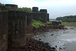
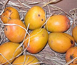
[[File:Bastions of vijaydurg.jpg|thumb|250px|Bastions of Vijaydurg fort]][[File:Alphonso mango.jpg|thumb|right|[[Alphonso (mango)|Alphonso mangoes]] (local name: ''Hapoos'') are grown mainly in [[Devgad]], [[Sindhudurg]] and [[Ratnagiri]] districts of [[Maharashtra]] and favored there, and are now popular in the United States.<ref>[https://www.nytimes.com/2006/05/10/travel/10mumbailetter.html?ei=5087&en=fa4b9b80768c5253&ex=1147665600&pagewanted=all Allen J. Mango mania in Portland, Oregon, New York Times, May 10, 2006]</ref>|alt=Photo of ten large mangoes]] | [[File:Bastions of vijaydurg.jpg|thumb|250px|Bastions of Vijaydurg fort]][[File:Alphonso mango.jpg|thumb|right|[[Alphonso (mango)|Alphonso mangoes]] (local name: ''Hapoos'') are grown mainly in [[Devgad]], [[Sindhudurg]] and [[Ratnagiri]] districts of [[Maharashtra]] and favored there, and are now popular in the United States.<ref>[https://www.nytimes.com/2006/05/10/travel/10mumbailetter.html?ei=5087&en=fa4b9b80768c5253&ex=1147665600&pagewanted=all Allen J. Mango mania in Portland, Oregon, New York Times, May 10, 2006]</ref>|alt=Photo of ten large mangoes]] | ||
'''Devgad''' is a [[taluka]] in [[Sindhudurg district]] of Maharashtra [[India]] consisting of 98 villages.<ref>[http://vlist.in/sub-district/04275.html India Village Directory]</ref> It is located on the [[Arabian Sea]] in the coastal [[Konkan]] region of Maharashtra, south of [[Mumbai]]. Devgad is known globally for its exports of locally grown [[Alphonso (mango)|Alphonso mango]]es.<ref>http://cultural.maharashtra.gov.in/english/gazetteer/RATNAGIRI/places_Devgad.html</ref> | '''Devgad''' is a [[taluka]] in [[Sindhudurg district]] of Maharashtra [[India]] consisting of 98 villages.<ref>[http://vlist.in/sub-district/04275.html India Village Directory]</ref> It is located on the [[Arabian Sea]] in the coastal [[Konkan]] region of Maharashtra, south of [[Mumbai]]. Devgad is known globally for its exports of locally grown [[Alphonso (mango)|Alphonso mango]]es.<ref>{{cite web |url=http://cultural.maharashtra.gov.in/english/gazetteer/RATNAGIRI/places_Devgad.html |title=Places of interest: Devgad |date= |website=Gazetteers |publisher=[[Ministry of Tourism (Maharashtra)|Department of Tourism and Culture]]}}</ref> | ||
Devgad is a natural harbour. However, only small vessels can enter the harbour.<ref name="lighthouse">{{cite web |title=DEVGAD LIGHTHOUSE |url=http://www.dgll.nic.in/WriteReadData/CMS/DEVGAD%20LIGHTHOUSE.pdf |website=ww.dgll.nic.in |accessdate=26 December 2019}}</ref> | Devgad is a natural harbour. However, only small vessels can enter the harbour.<ref name="lighthouse">{{cite web |title=DEVGAD LIGHTHOUSE |url=http://www.dgll.nic.in/WriteReadData/CMS/DEVGAD%20LIGHTHOUSE.pdf |website=ww.dgll.nic.in |accessdate=26 December 2019}}</ref> | ||
==History== | ==History== | ||
It is noted for its harbour, its beach, and a [[lighthouse]] built in 1915 at the [[Devgad fort]]. [[Shilahara|Shilahara dynasty]] Raja [[Bhoja II (Shilahara dynasty)|Bhoja II]] constructed [[Vijaydurg Fort|Fort Vijaydurg (Gheria)]], ruled later by [[Adil Shah]] and eventually by | It is noted for its harbour, its beach, and a [[lighthouse]] built in 1915 at the [[Devgad fort]]. [[Shilahara|Shilahara dynasty]] Raja [[Bhoja II (Shilahara dynasty)|Bhoja II]] constructed [[Vijaydurg Fort|Fort Vijaydurg (Gheria)]], ruled later by [[Adil Shah]] and eventually by [[Chhatrapati Shivaji Maharaj]] and lastly [[Kanhoji Angre]] is a national monument situated 45 minutes by road from the main city of Devgad. [[Vijaydurg Fort|Fort Vijaydurg]], named as the "Eastern Gibraltar" because of its virtual impregnability, was impressive as seen by British, Dutch, Portuguese armies and travellers 400 years ago and even today as seen by visitors. | ||
==Transportation== | ==Transportation== | ||
The nearest railway station is [[Kankavli]] on [[Konkan Railway]] on [[Mumbai]]-[[Goa]] road. From Kankavli, one can get an auto-rickshaw or a state transport bus to reach Devgad-Vijaydurg. | The nearest railway station is [[Kankavli]] on [[Konkan Railway]] on [[Mumbai]]-[[Goa]] road. From Kankavli, one can get an auto-rickshaw or a state transport bus to reach Devgad-Vijaydurg. | ||
There is a wall under the sea at shores of the Vijaydurg built such that an enemy's ships, trying to attack, would crash and sink. | There is a wall under the sea at shores of the Vijaydurg built such that an enemy's ships, trying to attack, would crash and sink. | ||
| Line 23: | Line 23: | ||
Fishing is carried out on a large scale in the sea as well as in the creeks throughout the taluka region. The staple diet of this region is rice and fish. | Fishing is carried out on a large scale in the sea as well as in the creeks throughout the taluka region. The staple diet of this region is rice and fish. | ||
The first windmill project in Maharashtra was installed at [[Girye]]. {{ | The first windmill project in Maharashtra was installed at [[Girye]]. {{citation needed|date=May 2021}} | ||
==Climate== | ==Climate== | ||
| Line 132: | Line 132: | ||
| publisher = India Meteorological Department | | publisher = India Meteorological Department | ||
| date = January 2015 | | date = January 2015 | ||
| pages = | | pages = 237–238 | ||
| accessdate = 5 April 2020}}</ref><ref name=IMDextremes> | | accessdate = 5 April 2020}}</ref><ref name=IMDextremes> | ||
{{cite web | {{cite web | ||
| Line 154: | Line 154: | ||
*'''Dirba Devi temple'''- A small village known as Jamsande is situated near to Devgad. The famous Dirba Devi goddess temple is located in jamsande. It is approximately 4 km from the Devgad bus stand. There is a small fair during ''Tripuri pourninam''<ref name="indiatourmate">{{cite web |title=DEVGAD TOURISM GUIDE |url=http://www.indiatourmate.com/devgad-tourist-places-tourism-guide.html |website=www.indiatourmate.com |publisher=indiatourmate |accessdate=26 December 2019}}</ref> | *'''Dirba Devi temple'''- A small village known as Jamsande is situated near to Devgad. The famous Dirba Devi goddess temple is located in jamsande. It is approximately 4 km from the Devgad bus stand. There is a small fair during ''Tripuri pourninam''<ref name="indiatourmate">{{cite web |title=DEVGAD TOURISM GUIDE |url=http://www.indiatourmate.com/devgad-tourist-places-tourism-guide.html |website=www.indiatourmate.com |publisher=indiatourmate |accessdate=26 December 2019}}</ref> | ||
*'''Devgad Lighthouse'''-The western coastline is highly sensitive, hence recently, Government of India installed static radar and electro-optic sensors at Devgad Lighthouse as a part of India's first coastal surveillance network. Devgad is one out of 46 locations chosen for the network and envisages real-time surveillance cover up to 25 nautical miles. | *'''Devgad Lighthouse'''-The western coastline is highly sensitive, hence recently, Government of India installed static radar and electro-optic sensors at Devgad Lighthouse as a part of India's first coastal surveillance network. Devgad is one out of 46 locations chosen for the network and envisages real-time surveillance cover up to 25 nautical miles. | ||
* '''Devgad Fort'''- This is situated | * '''Devgad Fort'''- This is situated 3 km from bus stand, on the east of the town. The Ganesh mandir and tree old cannons are worth visiting. This fort is situated on a small hillock close to the sea. Panoramic view of sea and the sunset view is best seen from the fort.<ref name="indiatourmate" /> | ||
* '''Devgad Beach'''- It is about | * '''Devgad Beach'''- It is about 2 km from the Devgad bus stand. | ||
==Demography== | ==Demography== | ||
Revision as of 03:50, 2 April 2022
 | This article needs more citations. (December 2012) |


Devgad is a taluka in Sindhudurg district of Maharashtra India consisting of 98 villages.[2] It is located on the Arabian Sea in the coastal Konkan region of Maharashtra, south of Mumbai. Devgad is known globally for its exports of locally grown Alphonso mangoes.[3]
Devgad is a natural harbour. However, only small vessels can enter the harbour.[4]
History
It is noted for its harbour, its beach, and a lighthouse built in 1915 at the Devgad fort. Shilahara dynasty Raja Bhoja II constructed Fort Vijaydurg (Gheria), ruled later by Adil Shah and eventually by Chhatrapati Shivaji Maharaj and lastly Kanhoji Angre is a national monument situated 45 minutes by road from the main city of Devgad. Fort Vijaydurg, named as the "Eastern Gibraltar" because of its virtual impregnability, was impressive as seen by British, Dutch, Portuguese armies and travellers 400 years ago and even today as seen by visitors.
Transportation
The nearest railway station is Kankavli on Konkan Railway on Mumbai-Goa road. From Kankavli, one can get an auto-rickshaw or a state transport bus to reach Devgad-Vijaydurg.
There is a wall under the sea at shores of the Vijaydurg built such that an enemy's ships, trying to attack, would crash and sink.
Trade
Devgad is also widely known for its pure Alphonso mango cultivation/farming and the whole development has evolved due to undertaking of the cultivation of Alphonso mango farming.[5] Mangoes grown here are characterized by their distinct aroma, smooth exterior, thin skin and thick saffron pulp. The variety is different from the Alphonso mangoes grown in the Ratnagiri district. Such is the popularity of the Devgad Alphonso mango that vendors often pass off other similar looking mangoes under the name of Devgad Alphonso. Devgad Alphonso mango is grown on an area of 45,000 acres and reaches a production of about 50,000 tons in a year of decent production. Devgad is also home to the oldest and biggest co-operative society of mango farmers in India, called the Devgad Taluka Amba Utpadak Sahakari Sanstha Maryadit[6] or Devgad Taluka Mango Growers Society Ltd with over 700 alphonso growers and 25-year-old in 2013.
Fishing is carried out on a large scale in the sea as well as in the creeks throughout the taluka region. The staple diet of this region is rice and fish.
The first windmill project in Maharashtra was installed at Girye. [citation needed]
Climate
| Climate data for Devgad taluka (1981–2010, extremes 1944–2006) | |||||||||||||
|---|---|---|---|---|---|---|---|---|---|---|---|---|---|
| Month | Jan | Feb | Mar | Apr | May | Jun | Jul | Aug | Sep | Oct | Nov | Dec | Year |
| Record high °C (°F) | 36.4 (97.5) |
36.9 (98.4) |
39.2 (102.6) |
37.2 (99.0) |
38.0 (100.4) |
37.2 (99.0) |
32.4 (90.3) |
33.0 (91.4) |
32.9 (91.2) |
36.6 (97.9) |
36.3 (97.3) |
35.2 (95.4) |
39.2 (102.6) |
| Average high °C (°F) | 30.8 (87.4) |
30.8 (87.4) |
31.4 (88.5) |
32.2 (90.0) |
33.4 (92.1) |
31.0 (87.8) |
29.2 (84.6) |
28.7 (83.7) |
29.4 (84.9) |
31.3 (88.3) |
32.6 (90.7) |
31.7 (89.1) |
31.0 (87.8) |
| Average low °C (°F) | 19.6 (67.3) |
20.2 (68.4) |
22.5 (72.5) |
24.5 (76.1) |
26.2 (79.2) |
24.4 (75.9) |
23.8 (74.8) |
23.4 (74.1) |
23.0 (73.4) |
23.3 (73.9) |
21.8 (71.2) |
20.5 (68.9) |
22.8 (73.0) |
| Record low °C (°F) | 15.4 (59.7) |
16.2 (61.2) |
18.4 (65.1) |
19.7 (67.5) |
19.4 (66.9) |
17.8 (64.0) |
18.0 (64.4) |
17.3 (63.1) |
17.3 (63.1) |
15.5 (59.9) |
14.1 (57.4) |
14.5 (58.1) |
14.1 (57.4) |
| Average rainfall mm (inches) | 0.0 (0.0) |
0.0 (0.0) |
0.0 (0.0) |
2.6 (0.10) |
76.9 (3.03) |
791.9 (31.18) |
786.4 (30.96) |
547.5 (21.56) |
270.0 (10.63) |
70.1 (2.76) |
13.7 (0.54) |
0.2 (0.01) |
2,559.3 (100.76) |
| Average rainy days | 0.0 | 0.0 | 0.0 | 0.3 | 2.5 | 17.9 | 23.1 | 23.9 | 13.3 | 4.1 | 1.2 | 0.1 | 86.3 |
| Average relative humidity (%) (at 17:30 IST) | 61 | 63 | 68 | 68 | 70 | 81 | 86 | 87 | 83 | 77 | 67 | 60 | 73 |
| Source: India Meteorological Department[7][8] | |||||||||||||
Places to visit
Devgad is slowly becoming a tourist hot spot for tourists who want to avoid Goa beaches. This is perfect for family outing in a peaceful and calm backdrop.
- Kunkeshwar shiva temple- There is a temple of Hindu deity Shiva which was built in 11th century situated in Kunkeshwar town, 16 Km from main city of Devgad. It is very famous for its Divinity and religious values across Maharashtra and people gather from across Maharashtra on the occasion of Mahashivratri.
- Shri Dev Rameshwar Temple- This is a 16th-century temple called as Shri Dev Rameshwar Temple, dedicated to lord shiva located at Rameshwar.
- Bhagwati Devi temple- There is a temple dedicated to the goddess Devi Bhagwati at the village of Munge.
- Vishweswarayya and Swami Kartikaswamy temple- There are temples to God Vishweswarayya and Swami Kartikaswamy at Hindale village.
- Rahateshwar temple- The temple of Shri Rahateshwar is in the village of Gadi Tamhane.
- Dirba Devi temple- A small village known as Jamsande is situated near to Devgad. The famous Dirba Devi goddess temple is located in jamsande. It is approximately 4 km from the Devgad bus stand. There is a small fair during Tripuri pourninam[9]
- Devgad Lighthouse-The western coastline is highly sensitive, hence recently, Government of India installed static radar and electro-optic sensors at Devgad Lighthouse as a part of India's first coastal surveillance network. Devgad is one out of 46 locations chosen for the network and envisages real-time surveillance cover up to 25 nautical miles.
- Devgad Fort- This is situated 3 km from bus stand, on the east of the town. The Ganesh mandir and tree old cannons are worth visiting. This fort is situated on a small hillock close to the sea. Panoramic view of sea and the sunset view is best seen from the fort.[9]
- Devgad Beach- It is about 2 km from the Devgad bus stand.
Demography
The following is a list of villages and their populations according to 2011 Census data:[10]
| # | Village | Administrative division | Population |
|---|---|---|---|
| 1 | Aadbandar | Devgad | 292 |
| 2 | Are | Devgad | 1,335 |
| 3 | Bagamala | Devgad | 303 |
| 4 | Bagatalavade | Devgad | 136 |
| 5 | Bandegaon | Devgad | 222 |
| 6 | Baparde | Devgad | 1,304 |
| 7 | Burabavade | Devgad | 603 |
| 8 | Chafed | Devgad | 629 |
| 9 | Chandoshi | Devgad | 697 |
| 10 | Chinchwad | Devgad | 280 |
| 11 | Dabhole | Devgad | 2,356 |
| 12 | Dahibaon | Devgad | 1,517 |
| 13 | Devgad | Devgad | 2,417 |
| 14 | Dhalavali | Devgad | 1,230 |
| 15 | Dhoptewadi | Devgad | 796 |
| 16 | Elaye | Devgad | 1,697 |
| 17 | Gadhitamhane | Devgad | 648 |
| 18 | Gavane | Devgad | 693 |
| 19 | Girye | Devgad | 2,457 |
| 20 | Goval | Devgad | 1,039 |
| 21 | Hadpid | Devgad | 522 |
| 22 | Hindale | Devgad | 1,714 |
| 23 | Hurshi | Devgad | 1,206 |
| 24 | Jamsande | Devgad | 14,487 |
| 25 | Juveshwar | Devgad | 1,057 |
| 26 | Kalambai | Devgad | 1,066 |
| 27 | Kalvi | Devgad | 604 |
| 28 | Kasaba Waghotan | Devgad | 313 |
| 29 | Katvan | Devgad | 794 |
| 30 | Katwaneshwar | Devgad | 829 |
| 31 | Khudi | Devgad | 1,527 |
| 32 | Kinjawade | Devgad | 2,491 |
| 33 | Korle | Devgad | 681 |
| 34 | Kotkamte | Devgad | 1,808 |
| 35 | Kunkawan | Devgad | 896 |
| 36 | Kunkeshwar | Devgad | 1,829 |
| 37 | Kuvale | Devgad | 1,255 |
| 38 | Lingdal | Devgad | 491 |
| 39 | Mahalunge | Devgad | 1,054 |
| 40 | Malegaon | Devgad | 1,025 |
| 41 | Malpewadi | Devgad | 632 |
| 42 | Manche | Devgad | 2,261 |
| 43 | Mithbaon | Devgad | 2,241 |
| 44 | Mithmumbari | Devgad | 920 |
| 45 | Mohulgaon | Devgad | 715 |
| 46 | Mond | Devgad | 1,564 |
| 47 | Mondpar | Devgad | 907 |
| 48 | Morve | Devgad | 408 |
| 49 | Mouje Waghotan | Devgad | 1,380 |
| 50 | Munage | Devgad | 1,883 |
| 51 | Mutat | Devgad | 1,933 |
| 52 | Nad | Devgad | 990 |
| 53 | Nadan | Devgad | 2,105 |
| 54 | Naringre | Devgad | 1,516 |
| 55 | Nimatwadi | Devgad | 629 |
| 56 | Ombal | Devgad | 527 |
| 57 | Padel | Devgad | 3,673 |
| 58 | Padthar | Devgad | 1,074 |
| 59 | Padvane | Devgad | 660 |
| 60 | Palekarwadi | Devgad | 1,210 |
| 61 | Patgaon | Devgad | 942 |
| 62 | Pavnai | Devgad | 732 |
| 63 | Pendhari | Devgad | 1,053 |
| 64 | Phanase | Devgad | 738 |
| 65 | Phanasgaon | Devgad | 1,328 |
| 66 | Pombhurle | Devgad | 1,910 |
| 67 | Poyare | Devgad | 943 |
| 68 | Pural | Devgad | 1,203 |
| 69 | Rahateshwar | Devgad | 628 |
| 70 | Rameshwar | Devgad | 2,099 |
| 71 | Rembavali | Devgad | 259 |
| 72 | Salashi | Devgad | 1,164 |
| 73 | Sandve | Devgad | 473 |
| 74 | Saundale | Devgad | 1,939 |
| 75 | Sherighera Kamte | Devgad | 4 |
| 76 | Shevare | Devgad | 368 |
| 77 | Shiravali | Devgad | 478 |
| 78 | Shirgaon | Devgad | 2,555 |
| 79 | Somlewadi | Devgad | 602 |
| 80 | Talavade | Devgad | 1,163 |
| 81 | Talebajar | Devgad | 689 |
| 82 | Tambaldeg | Devgad | 731 |
| 83 | Tembavali | Devgad | 829 |
| 84 | Thakurwadi | Devgad | 1,033 |
| 85 | Tirlot | Devgad | 2,307 |
| 86 | Torsole | Devgad | 1,172 |
| 87 | Undil | Devgad | 623 |
| 88 | Valivande | Devgad | 962 |
| 89 | Vijaydurg | Devgad | 1,735 |
| 90 | Virwadi | Devgad | 391 |
| 91 | Vitthaladevi | Devgad | 668 |
| 92 | Wadaker Poi | Devgad | 178 |
| 93 | Wade | Devgad | 1,728 |
| 94 | Wadetar | Devgad | 293 |
| 95 | Waghivare | Devgad | 381 |
| 96 | Wanivade | Devgad | 811 |
| 97 | Wareri | Devgad | 1,869 |
| 98 | Welgave | Devgad | 400 |
References
- ↑ Allen J. Mango mania in Portland, Oregon, New York Times, May 10, 2006
- ↑ India Village Directory
- ↑ "Places of interest: Devgad". Gazetteers. Department of Tourism and Culture.
- ↑ "DEVGAD LIGHTHOUSE" (PDF). ww.dgll.nic.in. Retrieved 26 December 2019.
- ↑ "Vagaries of nature, rising input costs to kill the famed Alphonso mango crop". The Times Of India. 18 April 2012. Retrieved 18 April 2012.
- ↑ "About Devgad Taluka". Devgad Mango. Retrieved 19 December 2019.
- ↑ "Station: Devgad (Devgarh) Climatological Table 1981–2010" (PDF). Climatological Normals 1981–2010. India Meteorological Department. January 2015. pp. 237–238. Archived from the original (PDF) on 5 February 2020. Retrieved 5 April 2020.
- ↑ "Extremes of Temperature & Rainfall for Indian Stations (Up to 2012)" (PDF). India Meteorological Department. December 2016. p. M142. Archived from the original (PDF) on 5 February 2020. Retrieved 5 April 2020.
- ↑ 9.0 9.1 "DEVGAD TOURISM GUIDE". www.indiatourmate.com. indiatourmate. Retrieved 26 December 2019.
- ↑ Directorate of Census Operations Maharashtra (2014). District Census Book Sindhudurg (PDF). Government of India. p. 95. Retrieved 27 December 2019.