WikiDwarfBOT (talk | contribs) m →References: Replace {{Source}} tag |
m robot: Update article (please report if you notice any mistake or error in this edit) |
||
| Line 1: | Line 1: | ||
{{Short description|External territory of Australia}} | |||
{{Redirect|Cocos Islands}} | |||
{{pp-move-vandalism|small=yes}} | |||
{{Use Australian English|date=March 2018}} | |||
{{Use dmy dates|date=December 2020}} | |||
{{Coord|12|07|03|S|96|53|42|E|region:CC|display=title}} | |||
{{Infobox dependency | {{Infobox dependency | ||
| name = Cocos (Keeling) Islands | | name = Cocos (Keeling) Islands | ||
| Line 4: | Line 12: | ||
| settlement_type = [[Australian Indian Ocean Territories|Australian Indian Ocean Territory]]<br />[[States and territories of Australia|External territory of Australia]] | | settlement_type = [[Australian Indian Ocean Territories|Australian Indian Ocean Territory]]<br />[[States and territories of Australia|External territory of Australia]] | ||
| image_flag = Flag of the Cocos (Keeling) Islands.svg | | image_flag = Flag of the Cocos (Keeling) Islands.svg | ||
| flag_size = | | flag_type = [[Flag of the Cocos (Keeling) Islands|Flag]] | ||
| flag_size = 130px | |||
| flag_link = | | flag_link = | ||
| motto = {{native name|coa|"Maju Pulu Kita"|italics=off}}<br/>({{lang-en|"Onward our island"}}) | | motto = {{native name|coa|"Maju Pulu Kita"|italics=off}}<br/>({{lang-en|"Onward our island"}}) | ||
| anthem = | | anthem = "''[[Advance Australia Fair]]''"<br><div style="padding-top:0.5em;" class="center">[[File:U.S. Navy Band, Advance Australia Fair (instrumental).ogg]]</div> | ||
| song_type = | | song_type = | ||
| song = | | song = | ||
| image_map = Australia on the globe (Cocos (Keeling) Islands special) (Southeast Asia centered).svg | | image_map = Australia on the globe (Cocos (Keeling) Islands special) (Southeast Asia centered).svg | ||
| Line 15: | Line 24: | ||
| mapsize = 290px | | mapsize = 290px | ||
| subdivision_type = [[Sovereign state]] | | subdivision_type = [[Sovereign state]] | ||
| subdivision_name = | | subdivision_name = {{flag|Australia}} | ||
| established_title = Annexed by the [[United Kingdom]] | | established_title = Annexed by the [[United Kingdom]] | ||
| established_date = 1857 | | established_date = 1857 | ||
| established_title2 = Transferred from Singapore<br/>to Australia | | established_title2 = Transferred from Singapore<br />to Australia | ||
| established_date2 = 23 November 1955 | | established_date2 = 23 November 1955 | ||
| official_languages = None | | official_languages = None | ||
| languages_type = Spoken languages | | languages_type = Spoken languages | ||
| languages = {{hlist|[[Cocos Malay|Malay]]|[[English language|English]]{{ | | languages = {{hlist|[[Cocos Malay|Malay]]|[[English language|English]]{{NoteTag|English does not have [[de jure]] status on the Cocos (Keeling) Islands and in Australia, but it is the [[de facto]] language of communication in government.}}}} | ||
| capital = [[West Island, Cocos (Keeling) Islands|West Island]] | | capital = [[West Island, Cocos (Keeling) Islands|West Island]] | ||
| coordinates = {{Coord|12|11|13|S|96|49|42|E|type:city}} | | coordinates = {{Coord|12|11|13|S|96|49|42|E|type:city}} | ||
| Line 38: | Line 47: | ||
| leader_name3 = [[Natasha Griggs]] | | leader_name3 = [[Natasha Griggs]] | ||
| leader_title4 = [[Shire of Cocos|Shire President]] | | leader_title4 = [[Shire of Cocos|Shire President]] | ||
|leader_name4 = | |leader_name4 = Aindil Minkom | ||
| area_km2 = 14 | | area_km2 = 14 | ||
| area_sq_mi = 5.3 | | area_sq_mi = 5.3 | ||
| Line 44: | Line 53: | ||
| elevation_max_m = 5 | | elevation_max_m = 5 | ||
| elevation_max_ft = | | elevation_max_ft = | ||
| population_census = 544 | | population_census = 544<ref name=Census2016/> | ||
| population_census_rank = not ranked | | population_census_rank = not ranked | ||
| population_census_year = 2016 | | population_census_year = 2016 | ||
| Line 55: | Line 64: | ||
| GDP_PPP_per_capita = | | GDP_PPP_per_capita = | ||
| GDP_PPP_per_capita_rank = | | GDP_PPP_per_capita_rank = | ||
| GDP_nominal = | | GDP_nominal = US$11,012,550<ref>{{cite book |last=Lundy |first=Kate |url = https://www.aph.gov.au/Parliamentary_Business/Committees/House_of_Representatives_Committees?url=/ncet/economicenvironment/report/chapter%203.pdf |title=Inquiry into the changing economic environment in the Indian Ocean Territories |publisher=Joint Standing Committee on the National Capital and External Territories| year=2010|isbn=978-0-642-79276-1|location=Parliament House, Canberra ACT |page=23 |chapter = Chapter 3: The economic environment of the Indian Ocean Territories }}</ref> | ||
| GDP_nominal_rank = | | GDP_nominal_rank = | ||
| GDP_nominal_year = | | GDP_nominal_year =2010 | ||
| GDP_nominal_per_capita = | | GDP_nominal_per_capita = | ||
| GDP_nominal_per_capita_rank = | | GDP_nominal_per_capita_rank = | ||
| Line 67: | Line 76: | ||
| timezone = | | timezone = | ||
| utc_offset = +06:30 | | utc_offset = +06:30 | ||
| drives_on = | | drives_on = left<ref>{{Cite web|url=https://www.worldstandards.eu/cars/list-of-left-driving-countries/?location=cn|title=List of left- & right-driving countries}}</ref> | ||
| calling_code = [[Telephone numbers in Australia|+61 891]] | | calling_code = [[Telephone numbers in Australia|+61 891]] | ||
| postal_code_type = [[Postcodes in Australia#External territories|Postcode]] | | postal_code_type = [[Postcodes in Australia#External territories|Postcode]] | ||
| Line 74: | Line 83: | ||
| cctld = [[.cc]] | | cctld = [[.cc]] | ||
}} | }} | ||
The '''Territory of Cocos (Keeling) Islands''' ({{lang-coa|Pulu Kokos (Keeling)}}) is a territory of [[Australia]]. | |||
The '''Cocos (Keeling) Islands''' ({{lang-coa|Pulu Kokos (Keeling)}}), officially the '''Territory of Cocos (Keeling) Islands''' ({{IPA-cen|ˈ|k|əʊ|k|ə|s}};<ref>{{Cite web |title=COCOS ISLANDS {{!}} Meaning & Definition for UK English {{!}} Lexico.com |url=https://www.lexico.com/definition/cocos_islands |access-date=2022-03-23 |website=Lexico Dictionaries {{!}} English |language=en}}</ref><ref>{{Cite web|last=Cocos Keeling Islands|url=https://www.youtube.com/watch?v=xmj571hdJzk&t=9s|title=Cocos Keeling Islands - Destination WA 2020 - Motorised Canoe Safari|date=2021-02-11|access-date=2022-03-23|website=YouTube}}</ref> {{lang-coa|Pulu Kokos (Keeling)}}), also simply called the '''Cocos Islands''' ({{lang-coa|Pulu Kokos}}), are an [[states and territories of Australia|Australian external territory]] in the [[Indian Ocean]], comprising a small archipelago approximately midway between Australia and [[Sri Lanka]] and relatively close to the Indonesian island of [[Sumatra]]. The territory's [[dual naming|dual name]] (official since the islands' incorporation into Australia in 1955) reflects that the islands have historically been known as either the '''Cocos Islands''' or the '''Keeling Islands'''. | |||
The territory consists of two [[atoll]]s made up of 27 [[coral island]]s, of which only two – [[West Island, Cocos (Keeling) Islands|West Island]] and [[Home Island]] – are inhabited. The population of around 600 people consists mainly of [[Cocos Malays]], who mostly practise [[Sunni Islam]] and speak [[Cocos Malay|a dialect of Malay]] as their first language.<ref name="cia">{{cite web |url = https://www.cia.gov/library/publications/the-world-factbook/geos/ck.html |title=Cocos (Keeling) Islands |work=The World Factbook |publisher=CIA |access-date=27 January 2012 |archive-url = https://web.archive.org/web/20090912042550/https://www.cia.gov/library/publications/the-world-factbook/geos/ck.html |archive-date=12 September 2009 |url-status=dead }}</ref> The territory is administered by the Australian federal government's [[Department of Infrastructure, Transport, Regional Development and Communications]] as an Australian external territory and together with [[Christmas Island]] (which is about {{convert|960|km|mi}} to the east) forms the [[Australian Indian Ocean Territories]] administrative grouping. However, the islanders do have a degree of self-government through [[Shire of Cocos|the local shire council]]. Many public services – including health, education, and policing – are provided by the state of [[Western Australia]], and Western Australian law applies except where the federal government has determined otherwise. The territory also uses Western Australian postcodes. | |||
The islands were discovered in 1609 by the British sea captain [[William Keeling]], but no settlement occurred until the early 19th century. One of the first settlers was John Clunies-Ross, a Scottish merchant; much of the island's current population is descended from the Malay workers he brought in to work his [[copra]] plantation. The [[Clunies-Ross family]] ruled the islands as a private fiefdom for almost 150 years, with the head of the family usually recognised as [[resident magistrate]]. The British annexed the islands in 1857, and for the next century they were administered from either [[British Ceylon|Ceylon]] or [[Colony of Singapore|Singapore]]. The territory was transferred to Australia in 1955, although until 1979 virtually all of the island's [[real estate]] still belonged to the Clunies-Ross family. | |||
== Name == | |||
[[File:Lagoon Beach (25152057091).jpg|300px|thumb|Home Island Beach]] | |||
The islands have been called the ''Cocos Islands'' (from 1622), the ''Keeling Islands'' (from 1703), the ''Cocos–Keeling Islands'' (since [[James Horsburgh]] in 1805) and the ''Keeling–Cocos Islands'' (19th century).<ref name="arb399p1t2">{{cite book |last1=Woodroffe|first1=C.D. |last2=Berry|first2=P.F. |title=Scientific Studies in the Cocos (Keeling) Islands: An Introduction|url=https://archive.org/stream/atollresearchbu399425smit#page/n14|series=Atoll Research Bulletin|volume=399|date=February 1994|publisher=National Museum of Natural History|location=Washington DC|pages=1–2|access-date=26 August 2015|archive-url=https://web.archive.org/web/20160410073158/https://archive.org/stream/atollresearchbu399425smit/#page/n14|archive-date=10 April 2016|url-status=live}}</ref> ''Cocos'' refers to the abundant [[coconut]] trees, while ''Keeling'' is [[William Keeling]], who discovered the islands in 1609.<ref name="arb399p1t2" /> | |||
John Clunies-Ross,<ref>{{cite web|title = Dynasties: Clunies-Ross |url = http://www.abc.net.au/dynasties/txt/s1227294.htm|website = www.abc.net.au|access-date = 2016-01-06|archive-url = https://web.archive.org/web/20140831132048/http://www.abc.net.au/dynasties/txt/s1227294.htm|archive-date = 31 August 2014|url-status = dead}}</ref> who sailed there in the ''Borneo'' in 1825, called the group the ''Borneo Coral Isles'', restricting ''Keeling'' to [[North Keeling]], and calling South Keeling "the Cocos properly so called".<ref>{{cite book|last=Horsburgh|first=James |author-link=James Horsburgh|title=The India directory, or, Directions for sailing to and from the East Indies, China, Australia, and the interjacent ports of Africa and South America: comp. chiefly from original journals of the honourable company's ships, and from observations and remarks, resulting from the experience of twenty-one years in the navigation of those seas|chapter-url=https://archive.org/stream/indiadirectoryor01hors#page/142/mode/2up|edition=5th|volume=1|year=1841|publisher=W.H. Allen and Co.|location=London |pages=141–2|chapter=Islands to the Southward and South-eastward of Java; The Keeling or Cocos Islands}}</ref><ref>{{cite book|last=Ross|first=J. C.|title=The Metropolitan|chapter-url=https://books.google.com/books?id=3h3ZAAAAMAAJ&pg=PA220|date=May 1835|publisher=Peck and Newton|page=220|chapter=The Cocos' Isles}}</ref> The form ''Cocos (Keeling) Islands'', attested from 1916,<ref name="WeberWeber1916">{{cite book|last1=Weber|first1=Max Carl Wilhelm|last2=Weber|first2=Lieven Ferdinand de Beaufort, Max Wilhelm Carl|title=The Fishes of the Indo-australian Archipelago|url=https://books.google.com/books?id=ZzhCAAAAIAAJ&pg=PA286|access-date=26 August 2015|year=1916|publisher=Brill Archive|page=286|archive-url=https://web.archive.org/web/20151231220345/https://books.google.com/books?id=ZzhCAAAAIAAJ&pg=PA286|archive-date=31 December 2015|url-status=live}}</ref> was made official by the Cocos (Keeling) Islands Act 1955.<ref name="arb399p1t2" /> | |||
The territory's Malay name is ''Pulu Kokos (Keeling)''. Sign boards on the island also feature Malay translations.<ref>{{cite web | url = https://s-media-cache-ak0.pinimg.com/originals/1a/22/b3/1a22b3506897ed6571e01f37ab80722c.jpg |title = Photo of a sign}}</ref><ref>{{cite web |url=https://diannewolfer.files.wordpress.com/2014/12/10429811_10152701070713780_7000322669539587620_n1.jpg |title=Archived copy |access-date=11 January 2018 |archive-url=https://web.archive.org/web/20180111170144/https://diannewolfer.files.wordpress.com/2014/12/10429811_10152701070713780_7000322669539587620_n1.jpg |archive-date=11 January 2018 |url-status=live }}</ref> | |||
== Geography == | |||
The Cocos (Keeling) Islands consist of two flat, low-lying coral atolls with an area of {{convert|14.2|km2|sqmi}}, {{convert|26|km|mi}} of coastline, a highest elevation of {{convert|5|m|ft}} and thickly covered with coconut palms and other vegetation. The climate is pleasant, moderated by the southeast [[trade winds]] for about nine months of the year and with moderate rainfall. [[Tropical cyclone]]s may occur in the early months of the year. | |||
[[North Keeling]] Island is an atoll consisting of just one C-shaped island, a nearly closed atoll ring with a small opening into the lagoon, about {{convert|50|m|ft}} wide, on the east side. The island measures {{convert|1.1|km2|acre}} in land area and is uninhabited. The lagoon is about {{convert|0.5|km2|acre}}. North Keeling Island and the surrounding sea to {{convert|1.5|km|mi|2|abbr=on}} from shore form the [[Pulu Keeling National Park]], established on 12 December 1995. It is home to the only surviving population of the endemic, and endangered, [[Cocos Buff-banded Rail]]. | |||
South Keeling Islands is an atoll consisting of 24 individual islets forming an incomplete atoll ring, with a total land area of {{convert|13.1|km2|sqmi}}. Only [[Home Island]] and [[West Island, Cocos (Keeling) Islands|West Island]] are populated. The Cocos Malays maintain weekend shacks, referred to as pondoks, on most of the larger islands. | |||
[[File:Cocos (Keeling) Islands-CIA WFB Map.png|thumb|right|200px|Cocos (Keeling) Islands]] | |||
[[File:Cocos Islands 1889.jpg|thumb|right|200px|1889 map of South Keeling Islands]] | |||
[[File:Cocos(keeling) 76.jpg|thumb|200px|right|1976 map of South Keeling Islands]] | |||
{| class="wikitable sortable" | |||
|+ Islets (clockwise from north) | |||
!rowspan=2| ||rowspan=2| Islet<br />(Malay name) ||rowspan=2| Translation of Malay name ||rowspan=2| English name||colspan=2| Area<br />(approx.) | |||
|- | |||
!align="right"|[[square kilometre|km<sup>2</sup>]] !! style="text-align:right;"|[[square mile|mi<sup>2</sup>]] | |||
|- | |||
| style="text-align:center;"| 1 || Pulau Luar || Outer Island || [[Horsburgh Island]] || {{convert|1.04|km2|mi2|2|disp=table}} | |||
|- | |||
| style="text-align:center;"| 2 || Pulau Tikus || Mouse Island || [[Direction Island, Cocos (Keeling) Islands|Direction Island]] ||align="right"| ||align="right"| | |||
|- | |||
| style="text-align:center;"| 3 || Pulau Pasir || Sand Island || Workhouse Island || {{convert|0.01|km2|mi2|2|disp=table}} | |||
|- | |||
| style="text-align:center;"| 4 || Pulau Beras || Rice Island || Prison Island || {{convert|0.02|km2|mi2|2|disp=table}} | |||
|- | |||
| style="text-align:center;"| 5 || Pulau Gangsa || Copper Island || Closed sandbar, now part of Home Island || {{convert|0.01|km2|mi2|2|disp=table}} | |||
|- | |||
| style="text-align:center;"| 6 || Pulau Selma || || [[Home Island]] || {{convert|0.95|km2|mi2|2|disp=table}} | |||
|- | |||
| style="text-align:center;"| 7 || Pulau Ampang Kechil || Little Ampang Island || Scaevola Islet || {{convert|0.01|km2|mi2|2|disp=table}} | |||
|- | |||
| style="text-align:center;"| 8 || Pulau Ampang || Ampang Island || Canui Island || {{convert|0.06|km2|mi2|2|disp=table}} | |||
|- | |||
| style="text-align:center;"| 9 || Pulau Wa-idas || || Ampang Minor || {{convert|0.02|km2|mi2|2|disp=table}} | |||
|- | |||
| style="text-align:center;"| 10 || Pulau Blekok || Pond Heron Island || Goldwater Island || {{convert|0.03|km2|mi2|2|disp=table}} | |||
|- | |||
| style="text-align:center;"| 11 || Pulau Kembang || Flower Island || Thorn Island || {{convert|0.04|km2|mi2|2|disp=table}} | |||
|- | |||
| style="text-align:center;"| 12 || Pulau Cheplok || Cape Gooseberry Island || Gooseberry Island || {{convert|0.01|km2|mi2|2|disp=table}} | |||
|- | |||
| style="text-align:center;"| 13 || Pulau Pandan || Pandan Island || Misery Island || {{convert|0.24|km2|mi2|2|disp=table}} | |||
|- | |||
| style="text-align:center;"| 14 || Pulau Siput || Snail Island || Goat Island || {{convert|0.10|km2|mi2|2|disp=table}} | |||
|- | |||
| style="text-align:center;"| 15 || Pulau Jambatan || Bridge Island || Middle Mission Isle || {{convert|0.01|km2|mi2|2|disp=table}} | |||
|- | |||
| style="text-align:center;"| 16 || Pulau Labu || Pumpkin Island || South Goat Island || {{convert|0.04|km2|mi2|2|disp=table}} | |||
|- | |||
| style="text-align:center;"| 17 || Pulau Atas || Top Island || [[South Island, Cocos (Keeling) Islands|South Island]] || {{convert|3.63|km2|mi2|2|disp=table}} | |||
|- | |||
| style="text-align:center;"| 18 || Pulau Kelapa Satu || One Coconut Island || North Goat Island || {{convert|0.02|km2|mi2|2|disp=table}} | |||
|- | |||
| style="text-align:center;"| 19 || Pulau Blan || || East Cay || {{convert|0.03|km2|mi2|2|disp=table}} | |||
|- | |||
| style="text-align:center;"| 20 || Pulau Blan Madar || || Burial Island || {{convert|0.03|km2|mi2|2|disp=table}} | |||
|- | |||
| style="text-align:center;"| 21 || Pulau Maria || Maria Island || West Cay || {{convert|0.01|km2|mi2|2|disp=table}} | |||
|- | |||
| style="text-align:center;"| 22 || Pulau Kambing || Goat Island || Keelingham Horn Island || {{convert|0.01|km2|mi2|2|disp=table}} | |||
|- | |||
| style="text-align:center;"| 23 || Pulau Panjang || Long Island || [[West Island, Cocos (Keeling) Islands|West Island]] || {{convert|6.23|km2|mi2|2|disp=table}} | |||
|- | |||
| style="text-align:center;"| 24 || Pulau Wak Bangka || || Turtle Island || {{convert|0.22|km2|mi2|2|disp=table}} | |||
|} | |||
There are no rivers or lakes on either atoll. Fresh water resources are limited to [[Lens (hydrology)|water lenses]] on the larger islands, underground accumulations of rainwater lying above the seawater. These lenses are accessed through shallow bores or wells. | |||
===Flora and fauna=== | |||
{{main|Flora of the Cocos (Keeling) Islands|Fauna of the Cocos (Keeling) Islands}} | |||
==Climate== | |||
Cocos (Keeling) Islands experience a [[tropical rainforest climate]] (''Af'') according to the [[Köppen climate classification]]; the archipelago lies approximately midway between the [[equator]] and the [[Tropic of Capricorn]]. The archipelago has two distinct seasons, the wet season and the dry season. The wettest month is April with precipitation totaling {{convert|262.6|mm}}, and the driest month is October with precipitation totaling {{convert|88.2|mm}}. Due to the strong maritime control, temperatures vary little although its location is some distance from the [[Equator]]. The hottest month is March with an average high temperature of {{convert|29.8|C}}, while the coolest month is August with an average low temperature of {{convert|23.6|C}}. | |||
{{Weather box | |||
|location = Cocos Islands Airport | |||
|metric first = yes | |||
|single line = yes | |||
|Jan record high C = 32.2 | |||
|Feb record high C = 32.2 | |||
|Mar record high C = 32.7 | |||
|Apr record high C = 32.8 | |||
|May record high C = 31.5 | |||
|Jun record high C = 30.8 | |||
|Jul record high C = 30.3 | |||
|Aug record high C = 30.3 | |||
|Sep record high C = 30.1 | |||
|Oct record high C = 31.0 | |||
|Nov record high C = 30.9 | |||
|Dec record high C = 31.4 | |||
|Jan high C = 29.8 | |||
|Feb high C = 29.9 | |||
|Mar high C = 30.0 | |||
|Apr high C = 29.8 | |||
|May high C = 29.3 | |||
|Jun high C = 28.6 | |||
|Jul high C = 28.1 | |||
|Aug high C = 28.1 | |||
|Sep high C = 28.2 | |||
|Oct high C = 28.6 | |||
|Nov high C = 29.0 | |||
|Dec high C = 29.4 | |||
|year high C = 29.1 | |||
|Jan low C = 25.1 | |||
|Feb low C = 25.2 | |||
|Mar low C = 25.4 | |||
|Apr low C = 25.5 | |||
|May low C = 25.4 | |||
|Jun low C = 24.8 | |||
|Jul low C = 24.3 | |||
|Aug low C = 24.3 | |||
|Sep low C = 24.2 | |||
|Oct low C = 24.5 | |||
|Nov low C = 24.8 | |||
|Dec low C = 24.8 | |||
|year low C = 24.9 | |||
|Jan record low C = 21.0 | |||
|Feb record low C = 20.1 | |||
|Mar record low C = 19.8 | |||
|Apr record low C = 22.2 | |||
|May record low C = 21.2 | |||
|Jun record low C = 21.5 | |||
|Jul record low C = 20.5 | |||
|Aug record low C = 20.8 | |||
|Sep record low C = 21.2 | |||
|Oct record low C = 21.3 | |||
|Nov record low C = 20.8 | |||
|Dec record low C = 21.2 | |||
|rain colour = green | |||
|Jan rain mm = 153.9 | |||
|Feb rain mm = 181.6 | |||
|Mar rain mm = 231.4 | |||
|Apr rain mm = 262.6 | |||
|May rain mm = 205.0 | |||
|Jun rain mm = 212.3 | |||
|Jul rain mm = 220.2 | |||
|Aug rain mm = 104.9 | |||
|Sep rain mm = 86.4 | |||
|Oct rain mm = 88.2 | |||
|Nov rain mm = 96.9 | |||
|Dec rain mm = 93.5 | |||
|unit rain days = 0.2 mm | |||
|Jan rain days = 12.9 | |||
|Feb rain days = 14.2 | |||
|Mar rain days = 18.3 | |||
|Apr rain days = 18.3 | |||
|May rain days = 18.9 | |||
|Jun rain days = 19.2 | |||
|Jul rain days = 21.4 | |||
|Aug rain days = 17.2 | |||
|Sep rain days = 13.5 | |||
|Oct rain days = 10.1 | |||
|Nov rain days = 10.1 | |||
|Dec rain days = 10.6 | |||
| source = [[Bureau of Meteorology]]<ref>{{cite web |url = http://www.bom.gov.au/jsp/ncc/cdio/cvg/av?p_stn_num=200284&p_prim_element_index=0&p_comp_element_index=0&redraw=null&p_display_type=full_statistics_table&normals_years=1981-2010&tablesizebutt=normal |title = Climate statistics for Australian locations. Cocos Island Airport |publisher = [[Australian Bureau of Meteorology]] }}</ref>}} | |||
==Demographics== | |||
In the {{CensusAU|2016}}, the population of the islands was 544 people of which 75% are Muslim, 13.4% are Buddhists, and 5% are Christians. The population’s 69.6% speak Malay rather than English at home.<ref name=Census2016>{{Census 2016 AUS|id=901021002|name=Cocos (Keeling) Islands|quick=yes|accessdate=10 October 2019}}</ref> The population on the two inhabited islands generally is split between the ethnic Europeans on West Island (estimated population 100) and the ethnic [[Cocos Malays|Malays]] on Home Island (estimated population 500).{{Citation needed|date=November 2021}} | |||
[[Kaum Ibu (Women's Group)]] is a [[women's rights]] organisation that represents the view of women at a local and national level.<ref>{{Cite book|last1=Jupp|first1=James|url=https://books.google.com/books?id=wgoFxfSTfYAC&dq=Kaum+Ibu+%28Women%27s+Group%29+cocos&pg=PA226|title=The Australian People: An Encyclopedia of the Nation, Its People and Their Origins|last2=Jupp|first2=Director Centre for Immigration and Multicultural Studies James|date=2001|publisher=Cambridge University Press|isbn=978-0-521-80789-0|language=en}}</ref> | |||
{{Pie chart | |||
|thumb = right | |||
|caption = Religion in Cocos Islands (2016) <ref>{{cite web|url=https://quickstats.censusdata.abs.gov.au/census_services/getproduct/census/2016/quickstat/901021002|title=2016 Census QuickStats: Cocos (Keeling) Islands|website=quickstats.censusdata.abs.gov.au}}</ref> | |||
|label1 = [[Islam]] | |||
|value1 = 75 | |||
|color1 = Green | |||
|label2 = [[Buddhism]] | |||
|value2 = 13.4 | |||
|color2 = Yellow | |||
|label3 = [[Christianity]] | |||
|value3 = 5 | |||
|color3 = Blue | |||
|value4=6.5|label4=Not stated|color4=Grey|value5=0.1|color5=Turquoise|label5=Other}} | |||
== History == | == History == | ||
===Discovery and early history=== | |||
[[File:AMH-5134-NA Compass chart of the Kokos islands.jpg|thumb|Historic compass chart of the Cocos islands<ref>Nationaal Archief, The Hague, archive 4.VEL inventorynumber 338</ref>]] | |||
The archipelago was discovered in 1609 by Captain [[William Keeling]] of the [[East India Company]], on a return voyage from the East Indies. [[North Keeling]] was sketched by Ekeberg, a Swedish captain, in 1749, showing the presence of [[coconut|coconut palm]]s. It also appears on a 1789 chart produced by British hydrographer [[Alexander Dalrymple]].<ref name=PKNPMP>{{cite book |year=2004 |title=Pulu Keeling National Park Management Plan |publisher=Australian Government |isbn=0-642-54964-8}}</ref> | |||
In 1825, Scottish merchant seaman Captain [[John Clunies-Ross]] stopped briefly at the islands on a trip to India, nailing up a [[Union Jack]] and planning to return and settle on the islands with his family in the future.<ref>{{cite web|url=https://books.google.com/books?id=4ohwAAAAIAAJ&pg=PA293|title=Gleanings in Science, Volume 2|date=1830|publisher=Baptist Mission Press|access-date=6 November 2015|archive-url=https://web.archive.org/web/20151231220345/https://books.google.com/books?id=4ohwAAAAIAAJ&pg=PA293|archive-date=31 December 2015|url-status=live}}</ref> Wealthy Englishman [[Alexander Hare]] had similar plans, and hired a captain{{spaced ndash}} coincidentally, Clunies-Ross's brother{{spaced ndash}}to bring him and a volunteer [[harem]] of 40 [[Malays (ethnic group)|Malay]] women to the islands, where he hoped to establish his private residence.<ref name="joshua">[[Joshua Slocum]], "[https://archive.org/stream/sailingalonearou00slocuoft#page/212/mode/2up Sailing Alone Around the World", p. 212] {{Webarchive|url=https://web.archive.org/web/20161226134257/https://archive.org/stream/sailingalonearou00slocuoft#page/212/mode/2up |date=26 December 2016 }}</ref> Hare had previously served as resident of [[Banjarmasin]], a town in [[Borneo]], and found that "he could not confine himself to the tame life that civilisation affords".<ref name="joshua"/> | |||
Clunies-Ross returned two years later with his wife, children and mother-in-law, and found Hare already established on the island and living with the private harem. A feud grew between the two.<ref name="joshua"/> Clunies-Ross's eight sailors "began at once the invasion of the new kingdom to take possession of it, women and all".<ref name="joshua"/> | |||
After some time, Hare's women began deserting him, and instead finding themselves mates amongst Clunies-Ross's sailors.<ref>[http://www.clunies-ross.com/ The Clunies-Ross Chronicle] {{webarchive |url=https://web.archive.org/web/20150905222330/http://www.clunies-ross.com/ |date=5 September 2015 }}</ref> Disheartened, Hare left the island. He died in [[Bencoolen (city)|Bencoolen]] in 1834.<ref>Morning Post (London) 20 March 1835</ref> Encouraged by members of the former harem, Clunies-Ross then recruited Malays to come to the island for work and wives. | |||
In | Clunies-Ross's workers were paid in a currency called the Cocos rupee, a currency John Clunies-Ross minted himself that could only be redeemed at the company store.<ref>{{cite news|url=http://news.bbc.co.uk/1/hi/programmes/from_our_own_correspondent/6730047.stm|title=BBC NEWS - Programmes - From Our Own Correspondent - The man who lost a 'coral kingdom'|access-date=19 October 2008|archive-url=https://web.archive.org/web/20080927212633/http://news.bbc.co.uk/1/hi/programmes/from_our_own_correspondent/6730047.stm|archive-date=27 September 2008|url-status=live}}</ref> | ||
[[File:Chart of Cocos Keeling Islands.png|thumb|220px|right|1840 chart of the Cocos (Keeling) Islands]] | |||
On 1 April 1836, {{HMS|Beagle}} under Captain [[Robert FitzRoy]] arrived to take soundings to establish the profile of the atoll as part of the [[second voyage of HMS Beagle|survey expedition of the ''Beagle'']]. To the naturalist [[Charles Darwin]], aboard the ship, the results supported a theory he had developed of how atolls formed, which he later published as ''[[The Structure and Distribution of Coral Reefs]]''. He studied the natural history of the islands and collected specimens.<ref>{{citation |last=Keynes |first=Richard |author-link=Richard Keynes |year=2001 |title=Charles Darwin's Beagle Diary |publisher=Cambridge University Press |url=http://darwin-online.org.uk/content/frameset?viewtype=text&itemID=F1925&pageseq=445 |pages=413–418 |access-date=20 January 2009 |archive-url=https://web.archive.org/web/20161226134647/http://darwin-online.org.uk/content/frameset?viewtype=text&itemID=F1925&pageseq=445 |archive-date=26 December 2016 |url-status=live}}</ref> Darwin's assistant [[Syms Covington]] noted that "an Englishman [he was in fact Scottish] and HIS family, with about sixty or seventy [[mulatto]]s from the [[Cape of Good Hope]], live on one of the islands. Captain Ross, the governor, is now absent at the Cape." | |||
===Annexation by the British Empire=== | |||
The islands were annexed by the British Empire in 1857.<ref name="Kenneth Roberts-Wray 1966. p. 882">Commonwealth and Colonial Law by [[Kenneth Roberts-Wray]], London, Stevens, 1966. p. 882</ref> This annexation was carried out by Captain [[Stephen Grenville Fremantle]] in command of {{HMS|Juno|1844|6}}. Fremantle claimed the islands for the British Empire and appointed [[King of the Cocos (Keeling) Islands|Ross II]] as Superintendent.<ref>{{cite journal|title=The Cocos Islands|journal=The Chambers's Journal|year=1899|volume=76|pages=187–190|url=https://books.google.com/books?id=ddUXAQAAIAAJ&pg=PA187|access-date=6 November 2015|archive-url=https://web.archive.org/web/20151231220345/https://books.google.com/books?id=ddUXAQAAIAAJ&pg=PA187|archive-date=31 December 2015|url-status=live}}</ref> In 1878, by [[Letters Patent]], the Governor of [[Ceylon]] was made Governor of the islands, and, by further Letters Patent in 1886,<ref>S.R.O. & S.I. Rev. XXI, 512.</ref> responsibility for the islands was transferred to the Governor of the [[Straits Settlement]] to exercise his functions as "Governor of Cocos Islands".<ref name="Kenneth Roberts-Wray 1966. p. 882"/> | |||
The islands were made part of the Straits Settlement under an Order in Council of 20 May 1903.<ref>S.R.O. 1903 No. 478, S.R.O. & S.I. Rev. XXI, 515</ref> Meanwhile, in 1886 [[Queen Victoria]] had, by indenture, granted the islands in perpetuity to John Clunies-Ross.<ref name="Kenneth Roberts-Wray 1966. p. 883">Commonwealth and Colonial Law by Kenneth Roberts-Wray, London, Stevens, 1966. p. 883</ref> The head of the family enjoyed semi-official status as [[Resident Magistrate]] and Government representative.<ref name="Kenneth Roberts-Wray 1966. p. 883"/> | |||
In 1901 a [[telegraph]] cable station was established on Direction Island. Undersea cables went to [[Rodrigues]], [[Mauritius]], [[Jakarta|Batavia]], [[Java]] and [[Fremantle]], [[Western Australia]]. In 1910 a wireless station was established to communicate with passing ships. The cable station ceased operation in 1966.<ref>{{cite web|url=https://www.cocoskeelingislands.com.au/home-2/history/money-22 |title=Timeline of major dates |access-date=2013-12-15 |url-status=dead |archive-url=https://web.archive.org/web/20131215033702/https://www.cocoskeelingislands.com.au/home-2/history/money-22 |archive-date=15 December 2013}}</ref> | |||
===World War I=== | |||
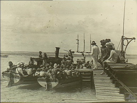
[[File:WW1 Landing at Direction Island.jpg|thumb|220px|right|A landing party from the [[Imperial German Navy|German Navy]] cruiser ''[[SMS Emden (1908)|Emden]]'' leaves the Cocos (Keeling) Islands via this jetty on [[Direction Island, Cocos (Keeling) Islands|Direction Island]] on 9 November 1914.]] | |||
{{main|Battle of Cocos}} | |||
On the morning of 9 November 1914, the islands became the site of the [[Battle of Cocos]], one of the first naval battles of [[World War I]]. A landing party from the German cruiser {{SMS|Emden|1906|6}} captured and disabled the wireless and cable communications station on [[Direction Island, Cocos (Keeling) Islands|Direction Island]], but not before the station was able to transmit a distress call. An Allied troop convoy was passing nearby, and the Australian cruiser {{HMAS|Sydney|1912|6}} was detached from the convoy escort to investigate. | |||
''Sydney'' spotted the island and ''Emden'' at 09:15, with both ships preparing for combat. At 11:20, the heavily damaged ''Emden'' beached herself on [[North Keeling Island]]. The Australian warship broke to pursue ''Emden''{{'}}s supporting [[Collier (ship)|collier]], which scuttled herself, then returned to North Keeling Island at 16:00. At this point, ''Emden''{{'}}s [[battle ensign]] was still flying: usually a sign that a ship intends to continue fighting. After no response to instructions to lower the ensign, two salvoes were shot into the beached cruiser, after which the Germans lowered the flag and raised a [[flag of surrender|white sheet]]. ''Sydney'' had orders to ascertain the status of the transmission station, but returned the next day to provide medical assistance to the Germans. | |||
Casualties totaled 134 personnel aboard ''Emden'' killed, and 69 wounded, compared to four killed and 16 wounded aboard ''Sydney''. The German survivors were taken aboard the Australian cruiser, which caught up to the troop convoy in [[Colombo]] on 15 November, then transported to [[Malta]] and handed over the prisoners to the [[British Army]]. An additional 50 German personnel from the shore party, unable to be recovered before ''Sydney'' arrived, commandeered a schooner and escaped from Direction Island, eventually arriving in [[Constantinople]]. ''Emden'' was the last active [[Central Powers]] warship in the Indian or Pacific Ocean, which meant troopships from Australia and New Zealand could sail without naval escort, and Allied ships could be deployed elsewhere. | |||
===World War II=== | |||
During [[World War II]], the cable station was once again a vital link. The Cocos were valuable for direction finding by the [[Y service]], the worldwide intelligence system used during the war.<ref>McKay, S. 2012. ''The Secret Listeners''. Aurum Press Ltd. {{ISBN|978 1 78131 079 3}}</ref> | |||
Allied planners noted that the islands might be seized as an airfield for [[Nazi Germany|German]] planes and as a base for commerce raiders operating in the Indian Ocean. Following [[Empire of Japan|Japan]]'s entry into the war, Japanese forces occupied neighbouring islands. To avoid drawing their attention to the Cocos cable station and its islands' garrison, the [[seaplane]] anchorage between Direction and [[Horsburgh Island|Horsburgh]] islands was not used. Radio transmitters were also kept silent, except in emergencies.{{citation needed|date=December 2009}} | |||
After the [[Fall of Singapore]] in 1942, the islands were administered from [[Ceylon]] ([[Sri Lanka]]), and West and Direction Islands were placed under [[Allies of World War II|Allied]] military administration. The islands' garrison initially consisted of a platoon from the British Army's [[King's African Rifles]], located on Horsburgh Island, with two {{convert|6|in|mm|adj=on|sigfig=4}} guns to cover the anchorage. The local inhabitants all lived on Home Island. Despite the importance of the islands as a communication centre, the Japanese made no attempt either to raid or to occupy them and contented themselves with sending over a reconnaissance aircraft about once a month. | |||
On the night of 8–9 May 1942, 15 members of the garrison, from the [[Ceylon Defence Force]], [[Mutiny|mutinied]] under the leadership of [[Gratien Fernando]]. The mutineers were said to have been provoked by the attitude of their British officers and were also supposedly inspired by Japanese anti-British propaganda. They attempted to take control of the [[Artillery|gun battery]] on the islands. The [[Cocos Islands Mutiny]] was crushed, but the mutineers murdered one non-mutinous soldier and wounded one officer. Seven of the mutineers were sentenced to death at a trial that was later alleged to have been improperly conducted, though the guilt of the accused was admitted. Four of the sentences were commuted, but three men were executed, including Fernando. These were to be the only [[Commonwealth of Nations|British Commonwealth]] soldiers executed for mutiny during the Second World War.<ref name=CIM>{{cite book |last=Cruise |first=Noel |title=The Cocos Islands Mutiny |publisher=Fremantle Arts Centre Press |year=2002 |location=Fremantle |page=248 |isbn=1-86368-310-0}}</ref> | |||
On 25 December 1942, the Japanese submarine ''[[Japanese submarine I-166|I-166]]'' bombarded the islands but caused no damage.<ref>{{cite web|url=http://www.combinedfleet.com/I-166.htm|title=Imperial Submarines|access-date=25 September 2008|archive-url=https://web.archive.org/web/20080921203309/http://www.combinedfleet.com/I-166.htm|archive-date=21 September 2008|url-status=live}}</ref> | |||
Later in the war, two airstrips were built, and three bomber squadrons were moved to the islands to conduct raids against Japanese targets in South East Asia and to provide support during the [[Operation Tiderace|planned]] reinvasion of [[British Malaya|Malaya]] and reconquest of Singapore. The first aircraft to arrive were [[Supermarine Spitfire]] Mk VIIIs of [[No. 136 Squadron RAF]].<ref>{{cite web|last=Fail|first=J.E.H.|title=FORWARD STRATEGIC AIR BASE COCOS ISLAND|url=http://www.rquirk.com/cocos/cocosart.htm|work=rquirk.com|access-date=13 February 2013|archive-url=https://web.archive.org/web/20130207075824/http://www.rquirk.com/cocos/cocosart.htm|archive-date=7 February 2013|url-status=live}}</ref> They included some [[B-24|Liberator]] bombers from [[No. 321 Squadron RAF|No. 321 (Netherlands) Squadron RAF]] (members of exiled Dutch forces serving with the [[Royal Air Force]]), which were also stationed on the islands. When in July 1945 [[No. 99 Squadron RAF|No. 99]] and [[No. 356 Squadron RAF|No. 356]] RAF squadrons arrived on West Island, they brought with them a daily newspaper called ''Atoll'' which contained news of what was happening in the outside world. Run by airmen in their off-duty hours, it achieved fame when dropped by Liberator bombers on POW camps over the heads of the Japanese guards. | |||
In 1946, the administration of the islands reverted to [[Colony of Singapore|Singapore]] and it became part of the [[Colony of Singapore]].<ref>Colony of Singapore. Government Gazette. (1 April 1946). The Singapore Colony Order in Council, 1946 (G.N. 2, pp. 2–3). Singapore: [s.n.]. Call no.: RCLOS 959.57 SGG; White paper on Malaya (26 January 1946). The Straits Times, p. 2. Retrieved from NewspaperSG; Tan, K. Y. L. (Ed.). (1999). The Singapore legal system (pp. 232–233). Singapore: Singapore University Press. Call no.: RSING 349.5957 SIN.</ref> | |||
===Transfer to Australia=== | |||
On 23 November 1955, the islands were transferred from the United Kingdom to the [[Commonwealth of Australia]]. Immediately before the transfer the islands were part of the United Kingdom's [[Colony of Singapore]], in accordance with the Straits Settlements (Repeal) Act, 1946 of the United Kingdom<ref>9 & 10 G. 6, c. 37</ref> and the British Settlements Acts, 1887 and 1945, as applied by the Act of 1946.<ref name="Kenneth Roberts-Wray 1966. p. 882"/> The legal steps for effecting the transfer were as follows:<ref>Commonwealth and Colonial Law by Kenneth Roberts-Wray, London, Stevens, 1966. pp. 133–134</ref> | |||
*The Commonwealth Parliament and the Government requested and consented to the enactment of a United Kingdom Act for the purpose. | |||
*The Cocos Islands Act, 1955, authorized Her Majesty, by Order in Council, to direct that the islands should cease to form part of the [[Colony of Singapore]] and be placed under the authority of the Commonwealth. | |||
*By the Cocos (Keeling) Islands Act, 1955, the Parliament of the Commonwealth provided for the acceptance of the islands as a territory under the authority of the Commonwealth and for its government. | |||
*The Cocos Islands Order in Council, 1955, made under the United Kingdom Act of 1955, provided that upon the appointed day (23 November 1955) the islands should cease to form part of the Colony of Singapore and be placed under the authority of the Commonwealth of Australia. | |||
The reason for this comparatively complex machinery was due to the terms of the Straits Settlement (Repeal) Act, 1946. According to Sir [[Kenneth Roberts-Wray]] "any other procedure would have been of doubtful validity".<ref>Commonwealth and Colonial Law by Kenneth Roberts-Wray, London, Stevens, 1966. p. 134</ref> The separation involved three steps: separation from the Colony of Singapore; transfer by United Kingdom and acceptance by Australia. | |||
H. J. Hull was appointed the first official representative (now administrator) of the new territory. He had been a lieutenant-commander in the Royal Australian Navy and was released for the purpose. Under Commonwealth Cabinet Decision 1573 of 9 September 1958, Hull's appointment was terminated and [[John William Stokes]] was appointed on secondment from the Northern Territory police. A media release at the end of October 1958 by the Minister for Territories, Hasluck, commended Hull's three years of service on Cocos. | |||
Stokes served in the position from 31 October 1958 to 30 September 1960. His son's boyhood memories and photos of the Islands have been published.<ref>{{cite book |last=Stokes |first=Tony |title=Whatever Will Be, I'll See: Growing Up in the 1940s, 50s and 60s in the Northern Territory, Christmas and the Cocos (Keeling) Islands, New South Wales and the Australian Capital Territory |year=2012 |publisher=Tony Stokes |isbn=9780646575643 |page=238}}</ref> C. I. Buffett [[Order of the British Empire|MBE]] from [[Norfolk Island]] succeeded him and served from 28 July 1960 to 30 June 1966, and later acted as Administrator back on Cocos and on Norfolk Island. In 1974, Ken Mullen wrote a small book<ref>{{cite book |title=Cocos Keeling, the Islands Time Forgot |year=1974 |author=Ken Mullen |publisher=Angus & Robertson |location=Sydney |page=122 |isbn=9780207131950 |oclc=1734040}}</ref> about his time with wife and son from 1964 to 1966 working at the Cable Station on Direction Island. | |||
In the 1970s, the Australian government's dissatisfaction with the Clunies-Ross feudal style of rule of the island increased. In 1978, Australia forced the family to sell the islands for the sum of {{currency|6,250,000|AUD}}, using the threat of compulsory acquisition. By agreement, the family retained ownership of Oceania House, their home on the island. In 1983, the Australian government reneged on this agreement and told [[Clunies-Ross Family#John Cecil Clunies-Ross|John Clunies-Ross]] that he should leave the Cocos. The following year the [[High Court of Australia]] ruled that resumption of Oceania House was unlawful, but the Australian government ordered that no government business was to be granted to Clunies-Ross's shipping company, an action that contributed to his bankruptcy.<ref>{{cite web|title = Cabinet papers: The last King of Cocos loses his palace|url = https://www.smh.com.au/nsw/cabinet-papers-the-last-king-of-cocos-loses-his-palace-20151217-glqb6m.html|website = The Sydney Morning Herald|access-date = 2016-01-01|archive-url = https://web.archive.org/web/20160101220559/http://www.smh.com.au/nsw/cabinet-papers-the-last-king-of-cocos-loses-his-palace-20151217-glqb6m.html|archive-date = 1 January 2016|url-status = live|date = 30 December 2015}}</ref> John Clunies-Ross later moved to [[Perth, Western Australia]]. However, some members of the Clunies-Ross family still live on the Cocos. | |||
Extensive preparations were undertaken by the government of Australia to prepare the Cocos Malays to vote in their referendum of self-determination. Discussions began in 1982, with an aim of holding the referendum, under United Nations supervision, in mid-1983. Under guidelines developed by the UN Decolonization Committee, residents were to be offered three choices: full independence, free association, or integration with Australia. The last option was preferred by both the islanders and the Australian government. A change in government in Canberra following the March 1983 Australian elections delayed the vote by one year. While the Home Island Council stated a preference for a traditional communal consensus "vote", the UN insisted on a secret ballot. [[1984 Cocos (Keeling) Islands status referendum|The referendum]] was held on 6 April 1984, with all 261 eligible islanders participating, including the Clunies-Ross family: 229 voted for integration, 21 for Free Association, nine for independence, and two failed to indicate a preference.<ref>Kenneth Chen, "Pacific Island Development Plan: Cocos (Keeling) Islands- The Political Evolution of a Small Island Territory in the Indian Ocean" (1987): Mr Chen was Administrator, Cocos Islands, from December 1983 – November 1985.</ref> In recent years a series of disputes have occurred between the Muslim and the non-Muslim population of the islands.<ref>{{cite web|url=https://www.theaustralian.com.au/news/inquirer/lost-in-transition/news-story/de35303c2eaa07c5ffd2a897e4a6e8a8|title=Lost in transition|date=2009-08-31|website=www.theaustralian.com.au|access-date=2018-12-27|archive-url=https://web.archive.org/web/20161223114416/http://www.theaustralian.com.au/news/inquirer/lost-in-transition/news-story/de35303c2eaa07c5ffd2a897e4a6e8a8|archive-date=23 December 2016|url-status=live}}</ref> | |||
===Indigenous status=== | |||
Descendants of the Cocos Malays brought to the islands from the [[Malay Peninsula]], the [[List of islands of Indonesia|Indonesian archipelago]], [[Southern Africa]] and [[New Guinea]] by Hare and by Clunies-Ross as [[Indentured servitude|indentured workers]], [[Slavery|slaves]] or [[convict]]s are {{as of|lc=yes|2019}} seeking recognition from the [[Government of Australia|Australian government]] to be acknowledged as [[Indigenous Australians]].<ref>{{cite web|website=The Conversation|url=https://theconversation.com/a-group-of-southeast-asian-descendants-wants-to-be-recognised-as-indigenous-australians-98186|title=A group of Southeast Asian descendants wants to be recognised as Indigenous Australians|date=25 June 2018|first1=Nicholas|last1=Herriman|first2=David R.M.|last2=Irving|first3=Greg|last3=Acciaioli|first4=Monika|last4=Winarnita|first5=Trixie Tangit|last5=Kinajil|access-date=2 December 2019|archive-url=https://web.archive.org/web/20190726020326/https://theconversation.com/a-group-of-southeast-asian-descendants-wants-to-be-recognised-as-indigenous-australians-98186|archive-date=26 July 2019|url-status=dead}}</ref> | |||
== Government == | == Government == | ||
The capital of the Territory of Cocos (Keeling) Islands is [[West Island, Cocos (Keeling) Islands|West Island]] while the largest settlement is the village of Bantam | The capital of the Territory of Cocos (Keeling) Islands is [[West Island, Cocos (Keeling) Islands|West Island]] while the largest settlement is the village of Bantam, on Home Island.{{Citation needed|date=August 2010}} | ||
== | |||
Governance of the islands is based on the ''Cocos (Keeling) Islands Act 1955''<ref>[http://www.weblaw.edu.au/weblaw/display_resource.phtml?rid=867 WebLaw – full resource metadata display<!-- Bot generated title -->] {{webarchive|url=https://web.archive.org/web/20080722153525/http://www.weblaw.edu.au/weblaw/display_resource.phtml?rid=867 |date=22 July 2008 }}</ref><ref>{{cite web|url= http://www.comlaw.gov.au/ComLaw/Legislation/ActCompilation1.nsf/0/D1D6D0EDD0A339E2CA25714100115B0A?OpenDocument| title=Cocos (Keeling) Islands Act 1955|access-date=5 November 2006|archive-url=https://web.archive.org/web/20070927000349/http://www.comlaw.gov.au/ComLaw/Legislation/ActCompilation1.nsf/0/D1D6D0EDD0A339E2CA25714100115B0A?OpenDocument |archive-date=27 September 2007|url-status=live}}</ref> and depends heavily on the laws of Australia. The islands are administered from [[Canberra]] by the [[Department of Infrastructure, Transport, Regional Development and Communications]] through a non-resident [[Administrator (Australia)|Administrator]] appointed by the [[Governor-General of Australia|Governor-General]]. They were previously the responsibility of the [[Department of Transport and Regional Services]] (before 2007), the [[Attorney-General's Department (Australia)|Attorney-General's Department]] (2007–2013), [[Department of Infrastructure and Regional Development]] (2013–2017) and [[Department of Infrastructure, Regional Development and Cities]] (2017-2020).<ref name="DOTARS">{{cite web| author = Department of Infrastructure, Transport, Regional Development and Local Government | title = Territories of Australia | url = http://www.infrastructure.gov.au/territories/index.aspx | access-date = 7 February 2008 | quote = As part of the Machinery of Government Changes following the Federal Election on 29 November 2007, administrative responsibility for Territories has been transferred to the Attorney General's Department. |archive-url = https://web.archive.org/web/20071216154140/http://www.infrastructure.gov.au/territories/index.aspx |archive-date = 16 December 2007}}</ref><ref name="AussieAG">{{cite web|author=First Assistant Secretary, Territories Division |title=Territories of Australia |url=http://www.ag.gov.au/territories |publisher=Attorney-General's Department |date=30 January 2008 |access-date=7 February 2008 |quote=The Federal Government, through the Attorney-General's Department administers Ashmore and Cartier Islands, Christmas Island, the Cocos (Keeling) Islands, the Coral Sea Islands, Jervis Bay, and Norfolk Island as Territories. |url-status=dead |archive-url=https://web.archive.org/web/20080206093322/http://www.ag.gov.au/territories |archive-date=6 February 2008 }}</ref> | |||
The current Administrator{{when|date=March 2022}} is [[Natasha Griggs]], who was appointed on 5 October 2017 and is also the Administrator of [[Christmas Island]].{{citation needed|date=March 2022}} These two territories comprise the [[Australian Indian Ocean Territories]]. The Australian Government provides Commonwealth-level government services through the Christmas Island Administration and the [[Department of Infrastructure and Regional Development]].<ref name="AAO Sep 2013">{{cite web|url=http://www.dpmc.gov.au/parliamentary/docs/aao_20130918.pdf |date=18 September 2013 |title=Commonwealth of Australia Administrative Arrangements Order made on 18 September 2013 |publisher=Australian Government Department of the Prime Minister and Cabinet |url-status=dead |archive-url=https://web.archive.org/web/20131014052331/http://www.dpmc.gov.au/parliamentary/docs/aao_20130918.pdf |archive-date=14 October 2013}}</ref> As per the Federal Government's ''Territories Law Reform Act 1992'', which came into force on 1 July 1992, [[Western Australia]]n laws are applied to the Cocos Islands, "so far as they are capable of applying in the Territory";<ref>{{cite web|url=http://www.comlaw.gov.au/Details/C2004A04395|title=Territories Law Reform Act 1992|access-date=13 March 2012|archive-url=https://web.archive.org/web/20120707074255/http://www.comlaw.gov.au/Details/C2004A04395|archive-date=7 July 2012|url-status=live}}</ref> non-application or partial application of such laws is at the discretion of the federal government. The Act also gives Western Australian courts judicial power over the islands. The Cocos Islands remain constitutionally distinct from Western Australia, however; the power of the state to legislate for the territory is power delegated by the federal government. The kind of services typically provided by a state government elsewhere in Australia are provided by departments of the Western Australian Government, and by contractors, with the costs met by the federal government.{{citation needed|date=March 2022}} | |||
There also exists a unicameral [[Shire of Cocos|Cocos (Keeling) Islands Shire Council]] with seven seats. A full term lasts four years, though elections are held every two years; approximately half the members retire each two years.{{citation needed|date=March 2022}} {{as of|March 2022}} the president of the shire is Aindil Minkom.<ref name="Birch 2022"/> | |||
===Federal politics=== | |||
{{bar box | |||
| title=Senate, 2016<ref name=senate/> | |||
| titlebar=#ddd | |||
| width= | |||
| float=right | |||
| bars= | |||
{{bar percent|[[Australian Labor Party|Labor]]|{{Australian politics/party colours|Labor}}|54.64}} | |||
{{bar percent|[[Rise Up Australia Party|Rise Up Australia]]|{{Australian politics/party colours|Rise Up Australia}}|22.86}} | |||
{{bar percent|[[Country Liberal Party|Country Liberal]]|{{Australian politics/party colours|CLP}}|11.07}} | |||
{{bar percent|[[Australian Greens|Greens]]|{{Australian politics/party colours|Greens}}|5.00}} | |||
{{bar percent|[[Citizens Electoral Council|CEC]]|{{Australian politics/party colours|CEC}}|3.21}} | |||
{{bar percent|[[Help End Marijuana Prohibition (HEMP) Party|HEMP]]/[[Australian Sex Party|Sex]]|{{Australian politics/party colours|Sex Party}}|3.21}} | |||
}} | |||
{{bar box | |||
| title=House of Representatives, 2016<ref name=house/> | |||
| titlebar=#ddd | |||
| width= | |||
| float=right | |||
| bars= | |||
{{bar percent|[[Australian Labor Party|Labor]]|{{Australian politics/party colours|Labor}}|64.34}} | |||
{{bar percent|[[Shooters, Fishers and Farmers Party|Shooters]]|{{Australian politics/party colours|Shooters}}|19.49}} | |||
{{bar percent|[[Country Liberal Party|Country Liberal]]|{{Australian politics/party colours|CLP}}|8.82}} | |||
{{bar percent|Others|{{Australian politics/party colours|Independent}}|4.41}} | |||
{{bar percent|[[Australian Greens|Greens]]|{{Australian politics/party colours|Greens}}|2.94}} | |||
}} | |||
Cocos (Keeling) Islands residents who are Australian citizens also vote in [[Elections in Australia|federal elections]]. Cocos (Keeling) Islanders are represented in the House of Representatives by the member for the [[Division of Lingiari]] (in the [[Northern Territory]]) and in the Senate by Northern Territory senators.<ref name="AEC">{{cite web|title=Profile of the electoral division of Lingiari (NT)|url=http://www.aec.gov.au/profiles/nt/lingiari.htm|publisher=Australian Electoral Commission|access-date=2 May 2016|archive-url=https://web.archive.org/web/20160425054016/http://www.aec.gov.au/profiles/nt/lingiari.htm|archive-date=25 April 2016|url-status=live}}</ref> At the [[2016 Australian federal election|2016 federal election]], the [[Australian Labor Party|Labor Party]] received absolute majorities from Cocos electors in both the House of Representatives and the Senate.<ref name=senate> | |||
Senate polling places: | |||
* [http://results.aec.gov.au/20499/Website/SenatePollingPlaceFirstPrefs-20499-8712.htm Home Island] {{Webarchive|url=https://web.archive.org/web/20180119235124/http://results.aec.gov.au/20499/Website/SenatePollingPlaceFirstPrefs-20499-8712.htm |date=19 January 2018 }} | |||
* [http://results.aec.gov.au/20499/Website/SenatePollingPlaceFirstPrefs-20499-34176.htm Home Island PPVC] {{Webarchive|url=https://web.archive.org/web/20180119235147/http://results.aec.gov.au/20499/Website/SenatePollingPlaceFirstPrefs-20499-34176.htm |date=19 January 2018 }} | |||
* [http://results.aec.gov.au/20499/Website/SenatePollingPlaceFirstPrefs-20499-8736.htm West Island] {{Webarchive|url=https://web.archive.org/web/20180119235120/http://results.aec.gov.au/20499/Website/SenatePollingPlaceFirstPrefs-20499-8736.htm |date=19 January 2018 }} | |||
</ref><ref name=house> | |||
House of Representatives polling places: | |||
* [http://results.aec.gov.au/20499/Website/HousePollingPlaceFirstPrefs-20499-8712.htm Home Island] {{Webarchive|url=https://web.archive.org/web/20180119235151/http://results.aec.gov.au/20499/Website/HousePollingPlaceFirstPrefs-20499-8712.htm |date=19 January 2018 }} | |||
* [http://results.aec.gov.au/20499/Website/HousePollingPlaceFirstPrefs-20499-34176.htm Home Island PPVC] {{Webarchive|url=https://web.archive.org/web/20180119235212/http://results.aec.gov.au/20499/Website/HousePollingPlaceFirstPrefs-20499-34176.htm |date=19 January 2018 }} | |||
* [http://results.aec.gov.au/20499/Website/HousePollingPlaceFirstPrefs-20499-8736.htm West Island] {{Webarchive|url=https://web.archive.org/web/20180119235215/http://results.aec.gov.au/20499/Website/HousePollingPlaceFirstPrefs-20499-8736.htm |date=19 January 2018 }} | |||
</ref> | |||
===Defence and law enforcement=== | |||
{{anchor | Defence | RAAF | Military }} | |||
Defence is the responsibility of the [[Australian Defence Force]]. There are no active military installations or defence personnel on the islands. The Administrator may request the assistance of the Australian Defence Force if required. The 2016 Australian Defence White Paper stated that the airfield in the island would be upgraded to support the [[Royal Australian Air Force|RAAF]]'s [[Boeing P-8 Poseidon|P-8 Poseidon]] maritime patrol aircraft.<ref>{{cite web|url=http://defence.gov.au/whitepaper/Docs/2016-Defence-White-Paper.pdf|title=2016 Defence White Paper (para. 4.66)|website=defence.gov.au|access-date=26 February 2016|archive-url=https://web.archive.org/web/20160301003400/http://defence.gov.au/WhitePaper/Docs/2016-Defence-White-Paper.pdf|archive-date=1 March 2016|url-status=live}}</ref> | |||
Civilian law enforcement and community policing is provided by the [[Australian Federal Police]]. The normal deployment to the island is one [[sergeant]] and one [[constable]]. These are augmented by two locally engaged Special Members who have police powers. | |||
===Courts=== | |||
{{see also|Supreme Court of the Cocos (Keeling) Islands}} | |||
Since 1992, court services have been provided by the [[Department of the Attorney General (Western Australia)|Western Australian Department of the Attorney-General]] under a service delivery arrangement with the Australian Government. Western Australian Court Services provide Magistrates Court, District Court, Supreme Court, Family Court, Children's Court, Coroner's Court and Registry for births, deaths and marriages and change of name services. Magistrates and judges from Western Australia convene a [[circuit court]] as required. | |||
===Health care=== | |||
Home Island and West Island have medical clinics providing basic health services, but serious medical conditions and injuries cannot be treated on the island and patients are sent to Perth for treatment, a distance of {{cvt|3000|km}}. | |||
== Economy == | |||
[[File:Cocos (keeling) Islands Product Exports (2019).svg|upright=1.3|thumb|right|Proportions of exports of the Cocos Islands, 2019]] | |||
The population of the islands is approximately 600. There is a small and growing tourist industry focused on water-based or nature activities. In 2016, a beach on Direction Island was named the best beach in Australia by [[Brad Farmer]], an Aquatic and Coastal Ambassador for Tourism Australia and co-author of ''101 Best Beaches 2017''.<ref>{{cite news|last1=Jackson|first1=Belinda|title=Cossies Beach, Cocos (Keeling) Islands: Beach expert Brad Farmer names Australia's best beach 2017|url=http://www.traveller.com.au/cossies-beach-wa-brad-farmers-best-beach-in-australia-in-2017-gt354u|access-date=4 December 2016|work=traveller.com.au|publisher=[[Fairfax Media]]|date=4 December 2016|archive-url=https://web.archive.org/web/20161203155158/http://www.traveller.com.au/cossies-beach-wa-brad-farmers-best-beach-in-australia-in-2017-gt354u|archive-date=3 December 2016|url-status=live}}</ref><ref>{{cite web|last1=Bonnor|first1=James|title=Australia appoints Brad Farmer to beach ambassador role|url=http://www.surfersvillage.com/content/australia-appoints-brad-farmer-beach-ambassador|website=www.surfersvillage.com|publisher=XTreme Video|access-date=4 December 2016|date=22 August 2016|archive-url=https://web.archive.org/web/20161220121210/http://www.surfersvillage.com/content/australia-appoints-brad-farmer-beach-ambassador|archive-date=20 December 2016|url-status=dead}}</ref> | |||
Small local gardens and fishing contribute to the food supply, but most food and most other necessities must be imported from Australia or elsewhere. | |||
The Cocos Islands Cooperative Society Ltd. employs construction workers, [[stevedore]]s, and [[lightering|lighterage]] worker operations. Tourism employs others. The unemployment rate was 6.7% in 2011.<ref>{{cite web|url=http://stat.abs.gov.au/itt/r.jsp?RegionSummary®ion=90102&dataset=ABS_REGIONAL_ASGS&geoconcept=REGION&datasetASGS=ABS_REGIONAL_ASGS&datasetLGA=ABS_REGIONAL_LGA®ionLGA=REGION®ionASGS=REGION|title=Cocos (Keeling) Islands : Region Data Summary|access-date=18 September 2015|archive-url=https://web.archive.org/web/20151015212025/http://stat.abs.gov.au/itt/r.jsp?RegionSummary®ion=90102&dataset=ABS_REGIONAL_ASGS&geoconcept=REGION&datasetASGS=ABS_REGIONAL_ASGS&datasetLGA=ABS_REGIONAL_LGA®ionLGA=REGION®ionASGS=REGION|archive-date=15 October 2015|url-status=live}}</ref> | |||
=={{anchor|plastic}}Plastic pollution== | |||
A 2019 study led by Jennifer Lavers from the [[University of Tasmania]]'s Institute of Marine and Antarctic Studies published in the journal ''[[Scientific Reports]]'' estimated the volume of [[plastic pollution|plastic rubbish]] on the Islands as around 414 million pieces, weighing 238 tonnes, 93% of which lies buried under the sand. It said that previous surveys which only assessed surface garbage probably "drastically underestimated the scale of debris accumulation". The plastic waste found in the study consisted mostly of single-use items such as bottles, [[plastic cutlery]], bags and [[drinking straw]]s.<ref>{{cite news|work=The Guardian|url=https://www.theguardian.com/environment/2019/may/16/414-million-pieces-of-plastic-found-on-remote-island-group-in-indian-ocean|title=414 million pieces of plastic found on remote island group in Indian Ocean|first=Ben|last=Smee|date=16 May 2019|access-date=7 October 2019}}</ref><ref>{{cite journal|journal=Scientific Reports| volume= 9|issue=Article number 7102 |date= 16 May 2019|authors=J. L. Lavers, L. Dicks, M. R. Dicks & A. Finger|title=Significant plastic accumulation on the Cocos (Keeling) Islands, Australia| page= 7102| doi= 10.1038/s41598-019-43375-4| pmid= 31097730| pmc= 6522509| bibcode= 2019NatSR...9.7102L}}</ref><ref>{{cite news|work=BBC News|url=https://www.bbc.com/news/science-environment-48272920|title=Plastic pollution: Flip-flop tide engulfs 'paradise' island|first=Matt|last=McGrath|date=16 May 2019|access-date=7 October 2019}}</ref><ref>{{cite news|publisher=Australian Broadcasting Corporation|website=ABC News|url=https://www.abc.net.au/news/science/2019-05-17/cocos-islands-millions-pieces-plastic-rubbish/11112784|title=Tonnes of plastic waste pollute Cocos Island beaches, and what you see is only a fragment|first=Jo|last=Kahn|date=17 May 2019|access-date=7 October 2019}}</ref> | |||
== Strategic importance == | |||
{{Update|section|date=November 2017}} | |||
The Cocos Islands are strategically important because of their proximity to shipping lanes in the [[Indian Ocean|Indian]] and [[Pacific Ocean|Pacific]] oceans.<ref name=wsws /> The United States and Australia have expressed interest in stationing surveillance drones on the Cocos Islands.<ref name="post">Whitlock, Craig, "[https://www.washingtonpost.com/world/national-security/us-to-expand-ties-with-australia-as-it-aims-to-shift-forces-closer-to-se-asia/2012/03/19/gIQAPSXlcS_story.html U.S., Australia to broaden military ties amid Pentagon pivot to SE Asia] {{Webarchive|url=https://archive.today/20130209004219/http://www.washingtonpost.com/world/national-security/us-to-expand-ties-with-australia-as-it-aims-to-shift-forces-closer-to-se-asia/2012/03/19/gIQAPSXlcS_story.html |date=9 February 2013 }}", ''[[The Washington Post]],'' 26 March 2012.</ref> [[Euronews]] described the plan as Australian support for an increased American presence in Southeast Asia, but expressed concern that it was likely to upset Chinese officials.<ref name="euro">Grubel, James, "[http://www.euronews.com/newswires/1459124-australia-open-to-us-spy-flights-from-indian-ocean-island/ Australia open to US spy flights from Indian Ocean]." [[Euronews]], 28 March 2012. {{webarchive |url=https://web.archive.org/web/20120527063046/http://www.euronews.com/newswires/1459124-australia-open-to-us-spy-flights-from-indian-ocean-island/ |date=27 May 2012 }}</ref> | |||
James Cogan has written for the [[World Socialist Web Site]] that the plan to station surveillance drones at Cocos is one component of former US President [[Barack Obama]]'s "pivot" towards Asia, facilitating control of the sea lanes and potentially allowing US forces to enforce a blockade against China.<ref name="wsws">Cogan, James, "[http://wsws.org/articles/2012/apr2012/darw-a14.shtml US Marines begin operations in northern Australia] {{Webarchive|url=https://web.archive.org/web/20120416030936/http://www.wsws.org/articles/2012/apr2012/darw-a14.shtml |date=16 April 2012 }}." ''[[World Socialist Web Site]]'', 14 April 2012.</ref> After plans to construct airbases were reported on by ''[[The Washington Post]]'',<ref>{{cite news |last1=Whitlock |first1=Craig |author1-link=Craig Whitlock |title=U.S., Australia announce deeper military ties amid Pentagon pivot to SE Asia |url=https://www.washingtonpost.com/world/national-security/us-to-expand-ties-with-australia-as-it-aims-to-shift-forces-closer-to-se-asia/2012/03/19/gIQAPSXlcS_story.html |access-date=9 December 2020 |newspaper=The Washington Post |date=26 March 2012}}</ref> Australian defence minister [[Stephen Smith (Australian politician)|Stephen Smith]] stated that the Australian government views the "Cocos as being potentially a long-term strategic location, but that is down the track."<ref>{{cite web |last1=Hawley |first1=Samantha |title=Cocos Islands: US military base, not in our lifetime |url=https://www.abc.net.au/pm/content/2012/s3465894.htm |website=abc.net.au |publisher=ABC |access-date=9 December 2020}}</ref> | |||
== Communications and transport == | |||
{{more citations needed section|date=August 2016}} | |||
===Transport=== | |||
The Cocos (Keeling) Islands have {{convert|15|km|spell=in|abbr=off}} of [[highway]]. | |||
There is one paved airport on the West Island. A tourist bus operates on Home Island. | |||
The only airport is [[Cocos (Keeling) Islands Airport]] with a single {{convert|2441|m|ft|abbr=on}} paved runway. [[Virgin Australia]] operates scheduled jet services from [[Perth Airport]] via Christmas Island. After 1952, the airport at Cocos Islands was a stop for airline flights between Australia and South Africa, and [[Qantas]] and [[South African Airways]] stopped there to refuel. The arrival of long-range jet aircraft ended this need in 1967. | |||
The Cocos Islands Cooperative Society operates an interisland ferry, the ''Cahaya Baru'', connecting West, Home and Direction Islands, as well as a bus service on West Island.<ref>{{cite web|url=https://www.cocoscoop.cc/logistics-group/#marine |title=Logistics Group - Cocos Islands Cooperative Society Ltd |publisher=Cocoscoop.cc |date= |accessdate=2022-02-19}}</ref> | |||
There is a [[lagoon]] anchorage between Horsburgh and Direction islands for larger vessels, while yachts have a dedicated anchorage area in the southern lee of Direction Island. There are no major [[seaport]]s on the islands. | |||
===Communications=== | |||
The islands are connected within Australia's telecommunication system (with number range +61 8 9162 xxxx). Public phones are located on both West Island and Home Island. A reasonably reliable GSM mobile phone network (number range +61 406 xxx), run by CiiA (Christmas Island Internet Association), operates on Cocos (Keeling) Islands. SIM cards (full size) and recharge cards can be purchased from the Telecentre on West Island to access this service. | |||
[[Australia Post]] provides mail services with the postcode 6799. There are post offices on West Island and Home Island. Standard letters and express post items are sent by air twice weekly, but all other mail is sent by sea and can take up to two months for delivery. | |||
===Internet=== | |||
[[.cc]] is the Internet country code top-level domain ([[ccTLD]]) for Cocos (Keeling) Islands. It is administered by VeriSign through a subsidiary company eNIC, which promotes it for international registration as "the next .com"; .cc was originally assigned in October 1997 to eNIC Corporation of Seattle WA by the IANA. The [[Turkish Republic of Northern Cyprus]] also uses the .cc domain, along with .nc.tr. | |||
Internet access on Cocos is provided by CiiA (Christmas Island Internet Association), and is supplied via satellite ground station on West Island, and distributed via a wireless PPPoE-based WAN on both inhabited islands. Casual internet access is available at the Telecentre on West Island and the Indian Ocean Group Training office on Home Island. | |||
The [[National Broadband Network]] announced in early 2012 that it would extend service to Cocos in 2015 via high-speed satellite link.<ref name="Gizmodo">Kidman, Alex, "[http://www.gizmodo.com.au/2012/02/nbn-to-launch-satellites-in-2015/ NBN To Launch Satellites in 2015] {{Webarchive|url=https://web.archive.org/web/20120912093443/http://www.gizmodo.com.au/2012/02/nbn-to-launch-satellites-in-2015/ |date=12 September 2012 }}." ''[[Gizmodo]]'', 8 February 2012.</ref> | |||
The Oman Australia Cable, scheduled for 2021, will feature a branch to the Cocos Islands.<ref>{{cite web|title=SUB.CO - Submarine Cable Infrastructure Development Specialists|url=https://www.sub.co/|access-date=2021-06-22|website=www.sub.co}}</ref><ref>{{cite web|title=Submarine Cable Map|url=https://www.submarinecablemap.com/|access-date=2021-06-22|website=www.submarinecablemap.com/}}</ref> | |||
== Media == | |||
The Cocos (Keeling) Islands have access to a range of modern communication services. Digital television stations are broadcast from Western Australia via satellite. A local radio station, 6CKI – Voice of the Cocos (Keeling) Islands, is staffed by community volunteers and provides some local content. | |||
===Newspapers=== | |||
The Cocos Islands Community Resource Centre publishes a fortnightly newsletter called ''The Atoll''. It is available in paper and electronic formats.<ref>{{cite web |title=The Atoll Newsletter |url=https://shire.cc/en/your-community/the-atoll-newsletter.html |website=Shire of Cocos Keeling Islands |access-date=13 August 2020}}</ref> | |||
===Television=== | |||
; Australian | |||
The Cocos (Keeling) Islands receives a range of digital channels from Western Australia via satellite and is broadcast from the Airport Building on the West Island on the following VHF frequencies: [[ABW (TV station)|ABC6]], [[Special Broadcasting Service|SBS7]], [[GWN7|WAW8]], [[WOW (TV station)|WOW10]] and [[West Digital Television|WDW11]]<ref>{{cite web|title=List of licensed broadcasting transmitters|url=http://www.acma.gov.au/Industry/Broadcast/Television/List-of-TV-broadcasters|publisher=ACMA|access-date=28 December 2013|archive-url=https://web.archive.org/web/20140211224613/http://www.acma.gov.au/Industry/Broadcast/Television/List-of-TV-broadcasters|archive-date=11 February 2014|url-status=dead}}</ref> | |||
; Malaysian | |||
From 2013 onwards, Cocos Island received four Malaysian channels via satellite: [[TV3 (Malaysia)|TV3]], [[ntv7]], [[8TV (Malaysia)|8TV]] and [[TV9 (Malaysia)|TV9]].{{citation needed|date=November 2017}} | |||
== Education == | |||
There is a school in the archipelago, [[Cocos Islands District High School]], with campuses located on West Island (Kindergarten to Year 10), and the other on Home Island (Kindergarten to Year 6). CIDHS is part of the [[Western Australia Department of Education]]. School instruction is in English on both campuses, with Cocos Malay teacher aides assisting the younger children in Kindergarten, Pre-Preparatory and early Primary with the English curriculum on the Home Island Campus. The Home Language of Cocos Malay is valued whilst students engage in learning English. | |||
==Culture== | |||
{{main|Culture of the Cocos (Keeling) Islands}} | |||
Although it is an Australian territory, the culture of the islands has extensive influences from [[Malaysia]] and [[Indonesia]] due to its predominantly ethnic Malay population. | |||
== Heritage listings == | |||
The [[West Island Mosque]] on Alexander Street is listed on the [[Australian Commonwealth Heritage List]].<ref name="ahd-105219">{{cite AHD|105219|West Island Mosque|fn=9/04/001/0013|access-date=15 May 2019}}</ref> | |||
== Museum == | |||
The [[Pulu Cocos Museum]] on [[Home Island]] was established in 1987, in recognition of the fact that the distinct culture of Home Island needed formal preservation.<ref>{{cite book|last=Conference|first=Museums Australia National|url=https://books.google.com/books?id=Sv0SAQAAMAAJ&q=cocos+island+museum |title=Unlocking Museums: The Proceedings : 4th National Conference of Museums Australia Inc|date=1997|publisher=Museums Australia|isbn=978-0-949069-23-8|language=en}}</ref><ref name=":1">{{cite web|title=Cocos (Keeling) Islands Shadow Puppets|url=https://australiapostcollectables.com.au/stamp-issues/cocos-keeling-islands-shadow-puppets |access-date=2021-09-04|website=Australia Post Collectables|language=en}}</ref> The site includes the displays on local culture and traditions, as well as the early history of the islands and their ownership by the [[Clunies-Ross family]].<ref>{{cite web |title = Home Island {{!}} Cocos Keeling Islands |url = https://www.cocoskeelingislands.com.au/home-island |access-date=2021-09-04 |website=www.cocoskeelingislands.com.au }}</ref><ref>{{cite web |author=RACWA |title=Things To Do on Christmas Island and Cocos Keeling Islands {{!}} RAC WA |url = https://rac.com.au/travel-touring/info/cocos-keeling-christmas-island |access-date=2021-09-04 |website = RAC WA - For a better WA |language=en-AU }}</ref> The museum also includes displays on military and naval history, as well as local botanical and zoological items.<ref name=":0">{{cite web |title=Cocos Museum |url = https://www.commonwealthwalkway.com/place/cocos-museum/ |access-date=2021-09-04 |website=Commonwealth Walkway Trust |language=en-GB }}</ref> | |||
== Marine park == | |||
Reefs near the islands have healthy [[coral]] and are home to several rare species of marine life. The region, along with the [[Christmas Island]] reefs, have been described as "Australia's [[Galapagos Islands]]".<ref name="Birch 2022"/> | |||
In the 2021 budget the Australian Government committed $A39.1M to create two new marine parks off [[Christmas Island]] and the Cocos (Keeling) Islands. The parks will cover up to {{convert|740,000|km2}} of Australian waters.<ref>{{cite web |url=https://budget.gov.au/2021-22/content/bp2/download/bp2_2021-22.pdf |title=Budget 2021–22 |date=11 May 2021 |publisher=Government of Australia |access-date=20 September 2021 |url-status=live|archive-url=https://web.archive.org/web/20210511093603/https://budget.gov.au/2021-22/content/bp2/download/bp2_2021-22.pdf |archive-date=11 May 2021 }}</ref> After months of consultation with local people, both parks were approved in March 2022, with a total coverage of {{convert|744,000|km2}}. The park will help to protect spawning of [[bluefin tuna]] from illegal international fishers, but local people will be allowed to practise fishing sustainably inshore in order to source food.<ref name="Birch 2022">{{cite web | last=Birch | first=Laura | title=Indian Ocean marine parks off Christmas Island and Cocos Islands get the go-ahead | website=ABC News| publisher= [[Australian Broadcasting Corporation]] | date=20 March 2022 | url=https://www.abc.net.au/news/2022-03-20/two-marine-parks-to-be-set-up-christmas-cocos-islands/100924776 | access-date=28 March 2022| archive-url=https://web.archive.org/web/20220326182102/https://www.abc.net.au/news/2022-03-20/two-marine-parks-to-be-set-up-christmas-cocos-islands/100924776| archive-date= 26 March 2022| url-status= live}}</ref> | |||
== Image gallery == | |||
<gallery widths="154px" heights="200px" caption="Gallery"> | |||
Cocos (Keeling) Islands Airport - RWY33.jpg|Aerial view of Cocos (Keeling) Islands Airport (ICAO code: YPCC). | |||
Cocos(Keeling)Islands HomeIsland02.jpg|[[Home Island, Cocos (Keeling) Islands|Home Island]]. | |||
HMAS Sydney 1912 compass-stand Port Macquarie.JPG|Compass stand from the bridge of [[HMAS Sydney (1912)|HMAS ''Sydney'']], which destroyed the [[SMS Emden|SMS ''Emden'']], installed at [[Port Macquarie]], [[New South Wales]], in 1929. | |||
SMS Emden 1914.jpg|A broadside view of the wrecked ''Emden'' after her encounter with HMAS ''Sydney''. Crew huddle on the wreck, awaiting rescue by ''Sydney''. | |||
BRIG DURRANT WRITING CANCELLED.jpg|The last bombing raid of [[World War II]] by [[No. 99 Squadron RAAF|99]], [[No. 356 Squadron RAF|356]] and [[No. 321 (Dutch) Squadron RAF|321 Squadron]]s is cancelled, 15 August 1945.<ref>Maj-General J. T. Durrant (SA Air Force, Commanding Officer, Cocos Islands), watched by Wing Commander "Sandy" Webster (Commanding Officer, 99 Squadron), Squadron Leader Les Evans (Acting Commanding Officer, 356 Squadron) and Lieutenant Commander W. van Prooijen (Commanding Officer, 321 Squadron).</ref> | |||
H.M. Queen Elizabeth and Prince Philip at the Cocos Islands, April 1954.jpg|[[Elizabeth II|Queen Elizabeth]] and [[Prince Philip, Duke of Edinburgh|Prince Philip]] arrive at the Cocos Islands, April 1954. | |||
Prince Philip-Queen Elizabeth-John Clunies Ross@Coco Islands 1954.jpg|Prince Philip waves goodbye as he and Queen Elizabeth, accompanied by [[John Clunies-Ross]], return to their ship from Home Island (1954). | |||
Elizabeth garden part 1954-04.jpg|Queen Elizabeth at a garden party held in her honour at Home Island (1954). | |||
</gallery> | |||
== See also == | |||
{{portal|Geography|Islands|<!--Eurasia-->|Asia|<!--Indian Ocean-->|Australia|<!-- Cocos (Keeling) Islands -->}} | |||
<!-- * [[Outline of the Cocos (Keeling) Islands]] --> | |||
<!-- * [[Bibliography of the Cocos (Keeling) Islands]] --> | |||
<!-- * {{wikipedia books link|Cocos (Keeling) Islands}} --> | |||
* [[Banknotes of the Cocos (Keeling) Islands]] | |||
* [[Index of Cocos (Keeling) Islands-related articles]] | |||
* [[Pearl Islands]] (''Isla de Cocos'', Panama; ''Cocos Island'', Costa Rica). | |||
== Notes == | |||
{{NoteFoot}} | |||
== References == | == References == | ||
=== Citations === | |||
{{reflist|colwidth=30em}} | |||
=== Sources === | |||
{{refbegin}} | |||
* {{CIA World Factbook |year = 2003 }} | |||
* Clunies-Ross, John Cecil; Souter, Gavin. ''The Clunies-Ross Cocos Chronicle'', Self, Perth 2009, {{ISBN|9780980586718}}. | |||
* {{cite book |last = McGrath |first = Tony |title = In Tropical Skies: A History of Aviation to Christmas Island and Cocos (Keeling) Islands |year = 2019 |publisher = Hesperian Press |location = Carlisle, WA |isbn = 9780859057561 }} | |||
{{refend}} | |||
== External links == | |||
{{Commons category|Cocos (Keeling) Islands}} | {{Commons category|Cocos (Keeling) Islands}} | ||
{{ | {{wikivoyage|Cocos (Keeling) Islands}} | ||
* [http://www.shire.cc/ Shire of Cocos (Keeling) Islands homepage] | |||
* [https://web.archive.org/web/20090327011339/http://www.botany.hawaii.edu/faculty/duffy/arb/497-508/505.pdf Areas of individual islets] | |||
* [https://web.archive.org/web/20070614165334/http://www.botany.hawaii.edu/faculty/duffy/arb/399-414/403.pdf Atoll Research Bulletin vol. 403] | |||
* [http://www.cocoskeelingislands.com.au/ Cocos (Keeling) Islands Tourism website] | |||
* [http://www.awm.gov.au/journal/j34/cocosmutiny.htm Noel Crusz, ''The Cocos Islands mutiny''], reviewed by Peter Stanley (Principal Historian, Australian War Memorial). | |||
* [http://news.bbc.co.uk/2/hi/programmes/from_our_own_correspondent/6730047.stm The man who lost a "coral kingdom"] | |||
* [https://dxnews.com/vk9ec_cocos_keeling/ Amateur Radio DX Pedition to Cocos (Keeling) Islands VK9EC] | |||
{{-}} | |||
{{Navboxes | |||
|title = Australia-related links | |||
|list = | |||
{{Australia topic |title=[[History of Australia]] |prefix=History of |VI=Victoria }} | |||
{{States and territories of Australia}} | |||
{{Politics of Australia by state}} | |||
}} | |||
{{Navboxes | |||
|title = Asia-related links | |||
|list = | |||
{{Geography of Asia}} | |||
{{Islands of Singapore |state = autocollapse }} | |||
{{Countries and territories of Southeast Asia}} | |||
{{Asia topic |Climate of}} | |||
}} | |||
{{Navboxes | |||
|title = Language-related links | |||
|list = | |||
{{English official language clickable map}} | |||
}} | |||
{{ | {{Authority control}} | ||
[[Category:Cocos (Keeling) Islands| ]] | [[Category:Cocos (Keeling) Islands| ]] | ||
[[Category: | [[Category:1955 establishments in Asia]] | ||
[[Category: | [[Category:1955 establishments in Australia]] | ||
[[Category: | [[Category:Archipelagoes of Australia]] | ||
[[Category:Archipelagoes of the Indian Ocean]] | |||
[[Category:British Malaya in World War II|.]] | |||
[[Category:British rule in Singapore]] | |||
[[Category:Island countries of the Indian Ocean]] | |||
[[Category:Islands of Southeast Asia]] | |||
[[Category:States and territories established in 1955]] | |||
[[Category:States and territories of Australia]] | |||
Revision as of 14:11, 15 June 2022
12°07′03″S 96°53′42″E / 12.11750°S 96.89500°E
Cocos (Keeling) Islands | |
|---|---|
| Territory of Cocos (Keeling) Islands Pulu Kokos (Keeling) (Cocos Islands Malay) Wilayah Kepulauan Cocos (Keeling) (Malay) | |
| Motto: | |
| Anthem: "Advance Australia Fair" | |
_Islands_special)_(Southeast_Asia_centered).svg) Location of the Cocos (Keeling) Islands (circled in red) | |
| Sovereign state |  Australia Australia |
| Annexed by the United Kingdom | 1857 |
| Transferred from Singapore to Australia | 23 November 1955 |
| Capital | West Island 12°11′13″S 96°49′42″E / 12.18694°S 96.82833°E |
| Largest village | Bantam (Home Island) |
| Official languages | None |
| Spoken languages | |
| Government | Directly administered dependency |
• Monarch | Elizabeth II |
| David Hurley | |
| Natasha Griggs | |
| Aindil Minkom | |
| Area | |
• Total | 14 km2 (5.4 sq mi) |
• Water (%) | 0 |
| Highest elevation | 5 m (16 ft) |
| Population | |
• 2016 census | 544[1] (not ranked) |
• Density | 43/km2 (111.4/sq mi) (not ranked) |
| GDP (nominal) | 2010 estimate |
• Total | US$11,012,550[2] |
| Currency | Australian dollar (AUD) |
| Time zone | UTC+06:30 |
| Driving side | left[3] |
| Calling code | +61 891 |
| Postcode | WA 6799 |
| ISO 3166 code | CC |
| Internet TLD | .cc |
_Islands.svg)
The Cocos (Keeling) Islands (Cocos Islands Malay: Pulu Kokos (Keeling)), officially the Territory of Cocos (Keeling) Islands (Template:IPA-cen;[4][5] Cocos Islands Malay: Pulu Kokos (Keeling)), also simply called the Cocos Islands (Cocos Islands Malay: Pulu Kokos), are an Australian external territory in the Indian Ocean, comprising a small archipelago approximately midway between Australia and Sri Lanka and relatively close to the Indonesian island of Sumatra. The territory's dual name (official since the islands' incorporation into Australia in 1955) reflects that the islands have historically been known as either the Cocos Islands or the Keeling Islands.
The territory consists of two atolls made up of 27 coral islands, of which only two – West Island and Home Island – are inhabited. The population of around 600 people consists mainly of Cocos Malays, who mostly practise Sunni Islam and speak a dialect of Malay as their first language.[6] The territory is administered by the Australian federal government's Department of Infrastructure, Transport, Regional Development and Communications as an Australian external territory and together with Christmas Island (which is about 960 kilometres (600 mi) to the east) forms the Australian Indian Ocean Territories administrative grouping. However, the islanders do have a degree of self-government through the local shire council. Many public services – including health, education, and policing – are provided by the state of Western Australia, and Western Australian law applies except where the federal government has determined otherwise. The territory also uses Western Australian postcodes.
The islands were discovered in 1609 by the British sea captain William Keeling, but no settlement occurred until the early 19th century. One of the first settlers was John Clunies-Ross, a Scottish merchant; much of the island's current population is descended from the Malay workers he brought in to work his copra plantation. The Clunies-Ross family ruled the islands as a private fiefdom for almost 150 years, with the head of the family usually recognised as resident magistrate. The British annexed the islands in 1857, and for the next century they were administered from either Ceylon or Singapore. The territory was transferred to Australia in 1955, although until 1979 virtually all of the island's real estate still belonged to the Clunies-Ross family.
Name
.jpg)
The islands have been called the Cocos Islands (from 1622), the Keeling Islands (from 1703), the Cocos–Keeling Islands (since James Horsburgh in 1805) and the Keeling–Cocos Islands (19th century).[7] Cocos refers to the abundant coconut trees, while Keeling is William Keeling, who discovered the islands in 1609.[7]
John Clunies-Ross,[8] who sailed there in the Borneo in 1825, called the group the Borneo Coral Isles, restricting Keeling to North Keeling, and calling South Keeling "the Cocos properly so called".[9][10] The form Cocos (Keeling) Islands, attested from 1916,[11] was made official by the Cocos (Keeling) Islands Act 1955.[7]
The territory's Malay name is Pulu Kokos (Keeling). Sign boards on the island also feature Malay translations.[12][13]
Geography
The Cocos (Keeling) Islands consist of two flat, low-lying coral atolls with an area of 14.2 square kilometres (5.5 sq mi), 26 kilometres (16 mi) of coastline, a highest elevation of 5 metres (16 ft) and thickly covered with coconut palms and other vegetation. The climate is pleasant, moderated by the southeast trade winds for about nine months of the year and with moderate rainfall. Tropical cyclones may occur in the early months of the year.
North Keeling Island is an atoll consisting of just one C-shaped island, a nearly closed atoll ring with a small opening into the lagoon, about 50 metres (160 ft) wide, on the east side. The island measures 1.1 square kilometres (270 acres) in land area and is uninhabited. The lagoon is about 0.5 square kilometres (120 acres). North Keeling Island and the surrounding sea to 1.5 km (0.93 mi) from shore form the Pulu Keeling National Park, established on 12 December 1995. It is home to the only surviving population of the endemic, and endangered, Cocos Buff-banded Rail.
South Keeling Islands is an atoll consisting of 24 individual islets forming an incomplete atoll ring, with a total land area of 13.1 square kilometres (5.1 sq mi). Only Home Island and West Island are populated. The Cocos Malays maintain weekend shacks, referred to as pondoks, on most of the larger islands.
_Islands-CIA_WFB_Map.png)

_76.jpg)
| Islet (Malay name) |
Translation of Malay name | English name | Area (approx.) | ||
|---|---|---|---|---|---|
| km2 | mi2 | ||||
| 1 | Pulau Luar | Outer Island | Horsburgh Island | 1.04 | 0.40 |
| 2 | Pulau Tikus | Mouse Island | Direction Island | ||
| 3 | Pulau Pasir | Sand Island | Workhouse Island | 0.01 | 0.00 |
| 4 | Pulau Beras | Rice Island | Prison Island | 0.02 | 0.01 |
| 5 | Pulau Gangsa | Copper Island | Closed sandbar, now part of Home Island | 0.01 | 0.00 |
| 6 | Pulau Selma | Home Island | 0.95 | 0.37 | |
| 7 | Pulau Ampang Kechil | Little Ampang Island | Scaevola Islet | 0.01 | 0.00 |
| 8 | Pulau Ampang | Ampang Island | Canui Island | 0.06 | 0.02 |
| 9 | Pulau Wa-idas | Ampang Minor | 0.02 | 0.01 | |
| 10 | Pulau Blekok | Pond Heron Island | Goldwater Island | 0.03 | 0.01 |
| 11 | Pulau Kembang | Flower Island | Thorn Island | 0.04 | 0.02 |
| 12 | Pulau Cheplok | Cape Gooseberry Island | Gooseberry Island | 0.01 | 0.00 |
| 13 | Pulau Pandan | Pandan Island | Misery Island | 0.24 | 0.09 |
| 14 | Pulau Siput | Snail Island | Goat Island | 0.10 | 0.04 |
| 15 | Pulau Jambatan | Bridge Island | Middle Mission Isle | 0.01 | 0.00 |
| 16 | Pulau Labu | Pumpkin Island | South Goat Island | 0.04 | 0.02 |
| 17 | Pulau Atas | Top Island | South Island | 3.63 | 1.40 |
| 18 | Pulau Kelapa Satu | One Coconut Island | North Goat Island | 0.02 | 0.01 |
| 19 | Pulau Blan | East Cay | 0.03 | 0.01 | |
| 20 | Pulau Blan Madar | Burial Island | 0.03 | 0.01 | |
| 21 | Pulau Maria | Maria Island | West Cay | 0.01 | 0.00 |
| 22 | Pulau Kambing | Goat Island | Keelingham Horn Island | 0.01 | 0.00 |
| 23 | Pulau Panjang | Long Island | West Island | 6.23 | 2.41 |
| 24 | Pulau Wak Bangka | Turtle Island | 0.22 | 0.08 | |
There are no rivers or lakes on either atoll. Fresh water resources are limited to water lenses on the larger islands, underground accumulations of rainwater lying above the seawater. These lenses are accessed through shallow bores or wells.
Flora and fauna
Climate
Cocos (Keeling) Islands experience a tropical rainforest climate (Af) according to the Köppen climate classification; the archipelago lies approximately midway between the equator and the Tropic of Capricorn. The archipelago has two distinct seasons, the wet season and the dry season. The wettest month is April with precipitation totaling 262.6 millimetres (10.34 in), and the driest month is October with precipitation totaling 88.2 millimetres (3.47 in). Due to the strong maritime control, temperatures vary little although its location is some distance from the Equator. The hottest month is March with an average high temperature of 29.8 °C (85.6 °F), while the coolest month is August with an average low temperature of 23.6 °C (74.5 °F).
| Climate data for Cocos Islands Airport | |||||||||||||
|---|---|---|---|---|---|---|---|---|---|---|---|---|---|
| Month | Jan | Feb | Mar | Apr | May | Jun | Jul | Aug | Sep | Oct | Nov | Dec | Year |
| Record high °C (°F) | 32.2 (90.0) |
32.2 (90.0) |
32.7 (90.9) |
32.8 (91.0) |
31.5 (88.7) |
30.8 (87.4) |
30.3 (86.5) |
30.3 (86.5) |
30.1 (86.2) |
31.0 (87.8) |
30.9 (87.6) |
31.4 (88.5) |
32.8 (91.0) |
| Average high °C (°F) | 29.8 (85.6) |
29.9 (85.8) |
30.0 (86.0) |
29.8 (85.6) |
29.3 (84.7) |
28.6 (83.5) |
28.1 (82.6) |
28.1 (82.6) |
28.2 (82.8) |
28.6 (83.5) |
29.0 (84.2) |
29.4 (84.9) |
29.1 (84.4) |
| Average low °C (°F) | 25.1 (77.2) |
25.2 (77.4) |
25.4 (77.7) |
25.5 (77.9) |
25.4 (77.7) |
24.8 (76.6) |
24.3 (75.7) |
24.3 (75.7) |
24.2 (75.6) |
24.5 (76.1) |
24.8 (76.6) |
24.8 (76.6) |
24.9 (76.8) |
| Record low °C (°F) | 21.0 (69.8) |
20.1 (68.2) |
19.8 (67.6) |
22.2 (72.0) |
21.2 (70.2) |
21.5 (70.7) |
20.5 (68.9) |
20.8 (69.4) |
21.2 (70.2) |
21.3 (70.3) |
20.8 (69.4) |
21.2 (70.2) |
19.8 (67.6) |
| Average rainfall mm (inches) | 153.9 (6.06) |
181.6 (7.15) |
231.4 (9.11) |
262.6 (10.34) |
205.0 (8.07) |
212.3 (8.36) |
220.2 (8.67) |
104.9 (4.13) |
86.4 (3.40) |
88.2 (3.47) |
96.9 (3.81) |
93.5 (3.68) |
1,936.9 (76.25) |
| Average rainy days (≥ 0.2 mm) | 12.9 | 14.2 | 18.3 | 18.3 | 18.9 | 19.2 | 21.4 | 17.2 | 13.5 | 10.1 | 10.1 | 10.6 | 184.7 |
| Source: Bureau of Meteorology[14] | |||||||||||||
Demographics
In the Template:CensusAU, the population of the islands was 544 people of which 75% are Muslim, 13.4% are Buddhists, and 5% are Christians. The population’s 69.6% speak Malay rather than English at home.[1] The population on the two inhabited islands generally is split between the ethnic Europeans on West Island (estimated population 100) and the ethnic Malays on Home Island (estimated population 500).[citation needed]
Kaum Ibu (Women's Group) is a women's rights organisation that represents the view of women at a local and national level.[15]
Religion in Cocos Islands (2016) [16]
History
Discovery and early history

The archipelago was discovered in 1609 by Captain William Keeling of the East India Company, on a return voyage from the East Indies. North Keeling was sketched by Ekeberg, a Swedish captain, in 1749, showing the presence of coconut palms. It also appears on a 1789 chart produced by British hydrographer Alexander Dalrymple.[18]
In 1825, Scottish merchant seaman Captain John Clunies-Ross stopped briefly at the islands on a trip to India, nailing up a Union Jack and planning to return and settle on the islands with his family in the future.[19] Wealthy Englishman Alexander Hare had similar plans, and hired a captain – coincidentally, Clunies-Ross's brother – to bring him and a volunteer harem of 40 Malay women to the islands, where he hoped to establish his private residence.[20] Hare had previously served as resident of Banjarmasin, a town in Borneo, and found that "he could not confine himself to the tame life that civilisation affords".[20]
Clunies-Ross returned two years later with his wife, children and mother-in-law, and found Hare already established on the island and living with the private harem. A feud grew between the two.[20] Clunies-Ross's eight sailors "began at once the invasion of the new kingdom to take possession of it, women and all".[20]
After some time, Hare's women began deserting him, and instead finding themselves mates amongst Clunies-Ross's sailors.[21] Disheartened, Hare left the island. He died in Bencoolen in 1834.[22] Encouraged by members of the former harem, Clunies-Ross then recruited Malays to come to the island for work and wives.
Clunies-Ross's workers were paid in a currency called the Cocos rupee, a currency John Clunies-Ross minted himself that could only be redeemed at the company store.[23]

On 1 April 1836, HMS Beagle under Captain Robert FitzRoy arrived to take soundings to establish the profile of the atoll as part of the survey expedition of the Beagle. To the naturalist Charles Darwin, aboard the ship, the results supported a theory he had developed of how atolls formed, which he later published as The Structure and Distribution of Coral Reefs. He studied the natural history of the islands and collected specimens.[24] Darwin's assistant Syms Covington noted that "an Englishman [he was in fact Scottish] and HIS family, with about sixty or seventy mulattos from the Cape of Good Hope, live on one of the islands. Captain Ross, the governor, is now absent at the Cape."
Annexation by the British Empire
The islands were annexed by the British Empire in 1857.[25] This annexation was carried out by Captain Stephen Grenville Fremantle in command of HMS Juno. Fremantle claimed the islands for the British Empire and appointed Ross II as Superintendent.[26] In 1878, by Letters Patent, the Governor of Ceylon was made Governor of the islands, and, by further Letters Patent in 1886,[27] responsibility for the islands was transferred to the Governor of the Straits Settlement to exercise his functions as "Governor of Cocos Islands".[25]
The islands were made part of the Straits Settlement under an Order in Council of 20 May 1903.[28] Meanwhile, in 1886 Queen Victoria had, by indenture, granted the islands in perpetuity to John Clunies-Ross.[29] The head of the family enjoyed semi-official status as Resident Magistrate and Government representative.[29]
In 1901 a telegraph cable station was established on Direction Island. Undersea cables went to Rodrigues, Mauritius, Batavia, Java and Fremantle, Western Australia. In 1910 a wireless station was established to communicate with passing ships. The cable station ceased operation in 1966.[30]
World War I

On the morning of 9 November 1914, the islands became the site of the Battle of Cocos, one of the first naval battles of World War I. A landing party from the German cruiser Template:SMS captured and disabled the wireless and cable communications station on Direction Island, but not before the station was able to transmit a distress call. An Allied troop convoy was passing nearby, and the Australian cruiser Template:HMAS was detached from the convoy escort to investigate.
Sydney spotted the island and Emden at 09:15, with both ships preparing for combat. At 11:20, the heavily damaged Emden beached herself on North Keeling Island. The Australian warship broke to pursue Emden's supporting collier, which scuttled herself, then returned to North Keeling Island at 16:00. At this point, Emden's battle ensign was still flying: usually a sign that a ship intends to continue fighting. After no response to instructions to lower the ensign, two salvoes were shot into the beached cruiser, after which the Germans lowered the flag and raised a white sheet. Sydney had orders to ascertain the status of the transmission station, but returned the next day to provide medical assistance to the Germans.
Casualties totaled 134 personnel aboard Emden killed, and 69 wounded, compared to four killed and 16 wounded aboard Sydney. The German survivors were taken aboard the Australian cruiser, which caught up to the troop convoy in Colombo on 15 November, then transported to Malta and handed over the prisoners to the British Army. An additional 50 German personnel from the shore party, unable to be recovered before Sydney arrived, commandeered a schooner and escaped from Direction Island, eventually arriving in Constantinople. Emden was the last active Central Powers warship in the Indian or Pacific Ocean, which meant troopships from Australia and New Zealand could sail without naval escort, and Allied ships could be deployed elsewhere.
World War II
During World War II, the cable station was once again a vital link. The Cocos were valuable for direction finding by the Y service, the worldwide intelligence system used during the war.[31]
Allied planners noted that the islands might be seized as an airfield for German planes and as a base for commerce raiders operating in the Indian Ocean. Following Japan's entry into the war, Japanese forces occupied neighbouring islands. To avoid drawing their attention to the Cocos cable station and its islands' garrison, the seaplane anchorage between Direction and Horsburgh islands was not used. Radio transmitters were also kept silent, except in emergencies.[citation needed]
After the Fall of Singapore in 1942, the islands were administered from Ceylon (Sri Lanka), and West and Direction Islands were placed under Allied military administration. The islands' garrison initially consisted of a platoon from the British Army's King's African Rifles, located on Horsburgh Island, with two 6-inch (152.4 mm) guns to cover the anchorage. The local inhabitants all lived on Home Island. Despite the importance of the islands as a communication centre, the Japanese made no attempt either to raid or to occupy them and contented themselves with sending over a reconnaissance aircraft about once a month.
On the night of 8–9 May 1942, 15 members of the garrison, from the Ceylon Defence Force, mutinied under the leadership of Gratien Fernando. The mutineers were said to have been provoked by the attitude of their British officers and were also supposedly inspired by Japanese anti-British propaganda. They attempted to take control of the gun battery on the islands. The Cocos Islands Mutiny was crushed, but the mutineers murdered one non-mutinous soldier and wounded one officer. Seven of the mutineers were sentenced to death at a trial that was later alleged to have been improperly conducted, though the guilt of the accused was admitted. Four of the sentences were commuted, but three men were executed, including Fernando. These were to be the only British Commonwealth soldiers executed for mutiny during the Second World War.[32]
On 25 December 1942, the Japanese submarine I-166 bombarded the islands but caused no damage.[33]
Later in the war, two airstrips were built, and three bomber squadrons were moved to the islands to conduct raids against Japanese targets in South East Asia and to provide support during the planned reinvasion of Malaya and reconquest of Singapore. The first aircraft to arrive were Supermarine Spitfire Mk VIIIs of No. 136 Squadron RAF.[34] They included some Liberator bombers from No. 321 (Netherlands) Squadron RAF (members of exiled Dutch forces serving with the Royal Air Force), which were also stationed on the islands. When in July 1945 No. 99 and No. 356 RAF squadrons arrived on West Island, they brought with them a daily newspaper called Atoll which contained news of what was happening in the outside world. Run by airmen in their off-duty hours, it achieved fame when dropped by Liberator bombers on POW camps over the heads of the Japanese guards.
In 1946, the administration of the islands reverted to Singapore and it became part of the Colony of Singapore.[35]
Transfer to Australia
On 23 November 1955, the islands were transferred from the United Kingdom to the Commonwealth of Australia. Immediately before the transfer the islands were part of the United Kingdom's Colony of Singapore, in accordance with the Straits Settlements (Repeal) Act, 1946 of the United Kingdom[36] and the British Settlements Acts, 1887 and 1945, as applied by the Act of 1946.[25] The legal steps for effecting the transfer were as follows:[37]
- The Commonwealth Parliament and the Government requested and consented to the enactment of a United Kingdom Act for the purpose.
- The Cocos Islands Act, 1955, authorized Her Majesty, by Order in Council, to direct that the islands should cease to form part of the Colony of Singapore and be placed under the authority of the Commonwealth.
- By the Cocos (Keeling) Islands Act, 1955, the Parliament of the Commonwealth provided for the acceptance of the islands as a territory under the authority of the Commonwealth and for its government.
- The Cocos Islands Order in Council, 1955, made under the United Kingdom Act of 1955, provided that upon the appointed day (23 November 1955) the islands should cease to form part of the Colony of Singapore and be placed under the authority of the Commonwealth of Australia.
The reason for this comparatively complex machinery was due to the terms of the Straits Settlement (Repeal) Act, 1946. According to Sir Kenneth Roberts-Wray "any other procedure would have been of doubtful validity".[38] The separation involved three steps: separation from the Colony of Singapore; transfer by United Kingdom and acceptance by Australia.
H. J. Hull was appointed the first official representative (now administrator) of the new territory. He had been a lieutenant-commander in the Royal Australian Navy and was released for the purpose. Under Commonwealth Cabinet Decision 1573 of 9 September 1958, Hull's appointment was terminated and John William Stokes was appointed on secondment from the Northern Territory police. A media release at the end of October 1958 by the Minister for Territories, Hasluck, commended Hull's three years of service on Cocos.
Stokes served in the position from 31 October 1958 to 30 September 1960. His son's boyhood memories and photos of the Islands have been published.[39] C. I. Buffett MBE from Norfolk Island succeeded him and served from 28 July 1960 to 30 June 1966, and later acted as Administrator back on Cocos and on Norfolk Island. In 1974, Ken Mullen wrote a small book[40] about his time with wife and son from 1964 to 1966 working at the Cable Station on Direction Island.
In the 1970s, the Australian government's dissatisfaction with the Clunies-Ross feudal style of rule of the island increased. In 1978, Australia forced the family to sell the islands for the sum of A$6,250,000, using the threat of compulsory acquisition. By agreement, the family retained ownership of Oceania House, their home on the island. In 1983, the Australian government reneged on this agreement and told John Clunies-Ross that he should leave the Cocos. The following year the High Court of Australia ruled that resumption of Oceania House was unlawful, but the Australian government ordered that no government business was to be granted to Clunies-Ross's shipping company, an action that contributed to his bankruptcy.[41] John Clunies-Ross later moved to Perth, Western Australia. However, some members of the Clunies-Ross family still live on the Cocos.
Extensive preparations were undertaken by the government of Australia to prepare the Cocos Malays to vote in their referendum of self-determination. Discussions began in 1982, with an aim of holding the referendum, under United Nations supervision, in mid-1983. Under guidelines developed by the UN Decolonization Committee, residents were to be offered three choices: full independence, free association, or integration with Australia. The last option was preferred by both the islanders and the Australian government. A change in government in Canberra following the March 1983 Australian elections delayed the vote by one year. While the Home Island Council stated a preference for a traditional communal consensus "vote", the UN insisted on a secret ballot. The referendum was held on 6 April 1984, with all 261 eligible islanders participating, including the Clunies-Ross family: 229 voted for integration, 21 for Free Association, nine for independence, and two failed to indicate a preference.[42] In recent years a series of disputes have occurred between the Muslim and the non-Muslim population of the islands.[43]
Indigenous status
Descendants of the Cocos Malays brought to the islands from the Malay Peninsula, the Indonesian archipelago, Southern Africa and New Guinea by Hare and by Clunies-Ross as indentured workers, slaves or convicts are as of 2019[update] seeking recognition from the Australian government to be acknowledged as Indigenous Australians.[44]
Government
The capital of the Territory of Cocos (Keeling) Islands is West Island while the largest settlement is the village of Bantam, on Home Island.[citation needed]
Governance of the islands is based on the Cocos (Keeling) Islands Act 1955[45][46] and depends heavily on the laws of Australia. The islands are administered from Canberra by the Department of Infrastructure, Transport, Regional Development and Communications through a non-resident Administrator appointed by the Governor-General. They were previously the responsibility of the Department of Transport and Regional Services (before 2007), the Attorney-General's Department (2007–2013), Department of Infrastructure and Regional Development (2013–2017) and Department of Infrastructure, Regional Development and Cities (2017-2020).[47][48]
The current Administrator[when?] is Natasha Griggs, who was appointed on 5 October 2017 and is also the Administrator of Christmas Island.[citation needed] These two territories comprise the Australian Indian Ocean Territories. The Australian Government provides Commonwealth-level government services through the Christmas Island Administration and the Department of Infrastructure and Regional Development.[49] As per the Federal Government's Territories Law Reform Act 1992, which came into force on 1 July 1992, Western Australian laws are applied to the Cocos Islands, "so far as they are capable of applying in the Territory";[50] non-application or partial application of such laws is at the discretion of the federal government. The Act also gives Western Australian courts judicial power over the islands. The Cocos Islands remain constitutionally distinct from Western Australia, however; the power of the state to legislate for the territory is power delegated by the federal government. The kind of services typically provided by a state government elsewhere in Australia are provided by departments of the Western Australian Government, and by contractors, with the costs met by the federal government.[citation needed]
There also exists a unicameral Cocos (Keeling) Islands Shire Council with seven seats. A full term lasts four years, though elections are held every two years; approximately half the members retire each two years.[citation needed] As of March 2022[update] the president of the shire is Aindil Minkom.[51]
Federal politics
Cocos (Keeling) Islands residents who are Australian citizens also vote in federal elections. Cocos (Keeling) Islanders are represented in the House of Representatives by the member for the Division of Lingiari (in the Northern Territory) and in the Senate by Northern Territory senators.[54] At the 2016 federal election, the Labor Party received absolute majorities from Cocos electors in both the House of Representatives and the Senate.[52][53]
Defence and law enforcement
Defence is the responsibility of the Australian Defence Force. There are no active military installations or defence personnel on the islands. The Administrator may request the assistance of the Australian Defence Force if required. The 2016 Australian Defence White Paper stated that the airfield in the island would be upgraded to support the RAAF's P-8 Poseidon maritime patrol aircraft.[55]
Civilian law enforcement and community policing is provided by the Australian Federal Police. The normal deployment to the island is one sergeant and one constable. These are augmented by two locally engaged Special Members who have police powers.
Courts
Since 1992, court services have been provided by the Western Australian Department of the Attorney-General under a service delivery arrangement with the Australian Government. Western Australian Court Services provide Magistrates Court, District Court, Supreme Court, Family Court, Children's Court, Coroner's Court and Registry for births, deaths and marriages and change of name services. Magistrates and judges from Western Australia convene a circuit court as required.
Health care
Home Island and West Island have medical clinics providing basic health services, but serious medical conditions and injuries cannot be treated on the island and patients are sent to Perth for treatment, a distance of 3,000 km (1,900 mi).
Economy
_Islands_Product_Exports_(2019).svg)
The population of the islands is approximately 600. There is a small and growing tourist industry focused on water-based or nature activities. In 2016, a beach on Direction Island was named the best beach in Australia by Brad Farmer, an Aquatic and Coastal Ambassador for Tourism Australia and co-author of 101 Best Beaches 2017.[56][57]
Small local gardens and fishing contribute to the food supply, but most food and most other necessities must be imported from Australia or elsewhere.
The Cocos Islands Cooperative Society Ltd. employs construction workers, stevedores, and lighterage worker operations. Tourism employs others. The unemployment rate was 6.7% in 2011.[58]
Plastic pollution
A 2019 study led by Jennifer Lavers from the University of Tasmania's Institute of Marine and Antarctic Studies published in the journal Scientific Reports estimated the volume of plastic rubbish on the Islands as around 414 million pieces, weighing 238 tonnes, 93% of which lies buried under the sand. It said that previous surveys which only assessed surface garbage probably "drastically underestimated the scale of debris accumulation". The plastic waste found in the study consisted mostly of single-use items such as bottles, plastic cutlery, bags and drinking straws.[59][60][61][62]
Strategic importance
 | This section needs to be updated. (November 2017) |
The Cocos Islands are strategically important because of their proximity to shipping lanes in the Indian and Pacific oceans.[63] The United States and Australia have expressed interest in stationing surveillance drones on the Cocos Islands.[64] Euronews described the plan as Australian support for an increased American presence in Southeast Asia, but expressed concern that it was likely to upset Chinese officials.[65]
James Cogan has written for the World Socialist Web Site that the plan to station surveillance drones at Cocos is one component of former US President Barack Obama's "pivot" towards Asia, facilitating control of the sea lanes and potentially allowing US forces to enforce a blockade against China.[63] After plans to construct airbases were reported on by The Washington Post,[66] Australian defence minister Stephen Smith stated that the Australian government views the "Cocos as being potentially a long-term strategic location, but that is down the track."[67]
Communications and transport
 | This section needs additional citations for verification. (August 2016) |
Transport
The Cocos (Keeling) Islands have 15 kilometres (9.3 miles)* of highway.
There is one paved airport on the West Island. A tourist bus operates on Home Island.
The only airport is Cocos (Keeling) Islands Airport with a single 2,441 m (8,009 ft) paved runway. Virgin Australia operates scheduled jet services from Perth Airport via Christmas Island. After 1952, the airport at Cocos Islands was a stop for airline flights between Australia and South Africa, and Qantas and South African Airways stopped there to refuel. The arrival of long-range jet aircraft ended this need in 1967.
The Cocos Islands Cooperative Society operates an interisland ferry, the Cahaya Baru, connecting West, Home and Direction Islands, as well as a bus service on West Island.[68]
There is a lagoon anchorage between Horsburgh and Direction islands for larger vessels, while yachts have a dedicated anchorage area in the southern lee of Direction Island. There are no major seaports on the islands.
Communications
The islands are connected within Australia's telecommunication system (with number range +61 8 9162 xxxx). Public phones are located on both West Island and Home Island. A reasonably reliable GSM mobile phone network (number range +61 406 xxx), run by CiiA (Christmas Island Internet Association), operates on Cocos (Keeling) Islands. SIM cards (full size) and recharge cards can be purchased from the Telecentre on West Island to access this service.
Australia Post provides mail services with the postcode 6799. There are post offices on West Island and Home Island. Standard letters and express post items are sent by air twice weekly, but all other mail is sent by sea and can take up to two months for delivery.
Internet
.cc is the Internet country code top-level domain (ccTLD) for Cocos (Keeling) Islands. It is administered by VeriSign through a subsidiary company eNIC, which promotes it for international registration as "the next .com"; .cc was originally assigned in October 1997 to eNIC Corporation of Seattle WA by the IANA. The Turkish Republic of Northern Cyprus also uses the .cc domain, along with .nc.tr.
Internet access on Cocos is provided by CiiA (Christmas Island Internet Association), and is supplied via satellite ground station on West Island, and distributed via a wireless PPPoE-based WAN on both inhabited islands. Casual internet access is available at the Telecentre on West Island and the Indian Ocean Group Training office on Home Island.
The National Broadband Network announced in early 2012 that it would extend service to Cocos in 2015 via high-speed satellite link.[69]
The Oman Australia Cable, scheduled for 2021, will feature a branch to the Cocos Islands.[70][71]
Media
The Cocos (Keeling) Islands have access to a range of modern communication services. Digital television stations are broadcast from Western Australia via satellite. A local radio station, 6CKI – Voice of the Cocos (Keeling) Islands, is staffed by community volunteers and provides some local content.
Newspapers
The Cocos Islands Community Resource Centre publishes a fortnightly newsletter called The Atoll. It is available in paper and electronic formats.[72]
Television
- Australian
The Cocos (Keeling) Islands receives a range of digital channels from Western Australia via satellite and is broadcast from the Airport Building on the West Island on the following VHF frequencies: ABC6, SBS7, WAW8, WOW10 and WDW11[73]
- Malaysian
From 2013 onwards, Cocos Island received four Malaysian channels via satellite: TV3, ntv7, 8TV and TV9.[citation needed]
Education
There is a school in the archipelago, Cocos Islands District High School, with campuses located on West Island (Kindergarten to Year 10), and the other on Home Island (Kindergarten to Year 6). CIDHS is part of the Western Australia Department of Education. School instruction is in English on both campuses, with Cocos Malay teacher aides assisting the younger children in Kindergarten, Pre-Preparatory and early Primary with the English curriculum on the Home Island Campus. The Home Language of Cocos Malay is valued whilst students engage in learning English.
Culture
Although it is an Australian territory, the culture of the islands has extensive influences from Malaysia and Indonesia due to its predominantly ethnic Malay population.
Heritage listings
The West Island Mosque on Alexander Street is listed on the Australian Commonwealth Heritage List.[74]
Museum
The Pulu Cocos Museum on Home Island was established in 1987, in recognition of the fact that the distinct culture of Home Island needed formal preservation.[75][76] The site includes the displays on local culture and traditions, as well as the early history of the islands and their ownership by the Clunies-Ross family.[77][78] The museum also includes displays on military and naval history, as well as local botanical and zoological items.[79]
Marine park
Reefs near the islands have healthy coral and are home to several rare species of marine life. The region, along with the Christmas Island reefs, have been described as "Australia's Galapagos Islands".[51]
In the 2021 budget the Australian Government committed $A39.1M to create two new marine parks off Christmas Island and the Cocos (Keeling) Islands. The parks will cover up to 740,000 square kilometres (290,000 sq mi) of Australian waters.[80] After months of consultation with local people, both parks were approved in March 2022, with a total coverage of 744,000 square kilometres (287,000 sq mi). The park will help to protect spawning of bluefin tuna from illegal international fishers, but local people will be allowed to practise fishing sustainably inshore in order to source food.[51]
Image gallery
- Gallery
-
 Aerial view of Cocos (Keeling) Islands Airport (ICAO code: YPCC).
 -

-
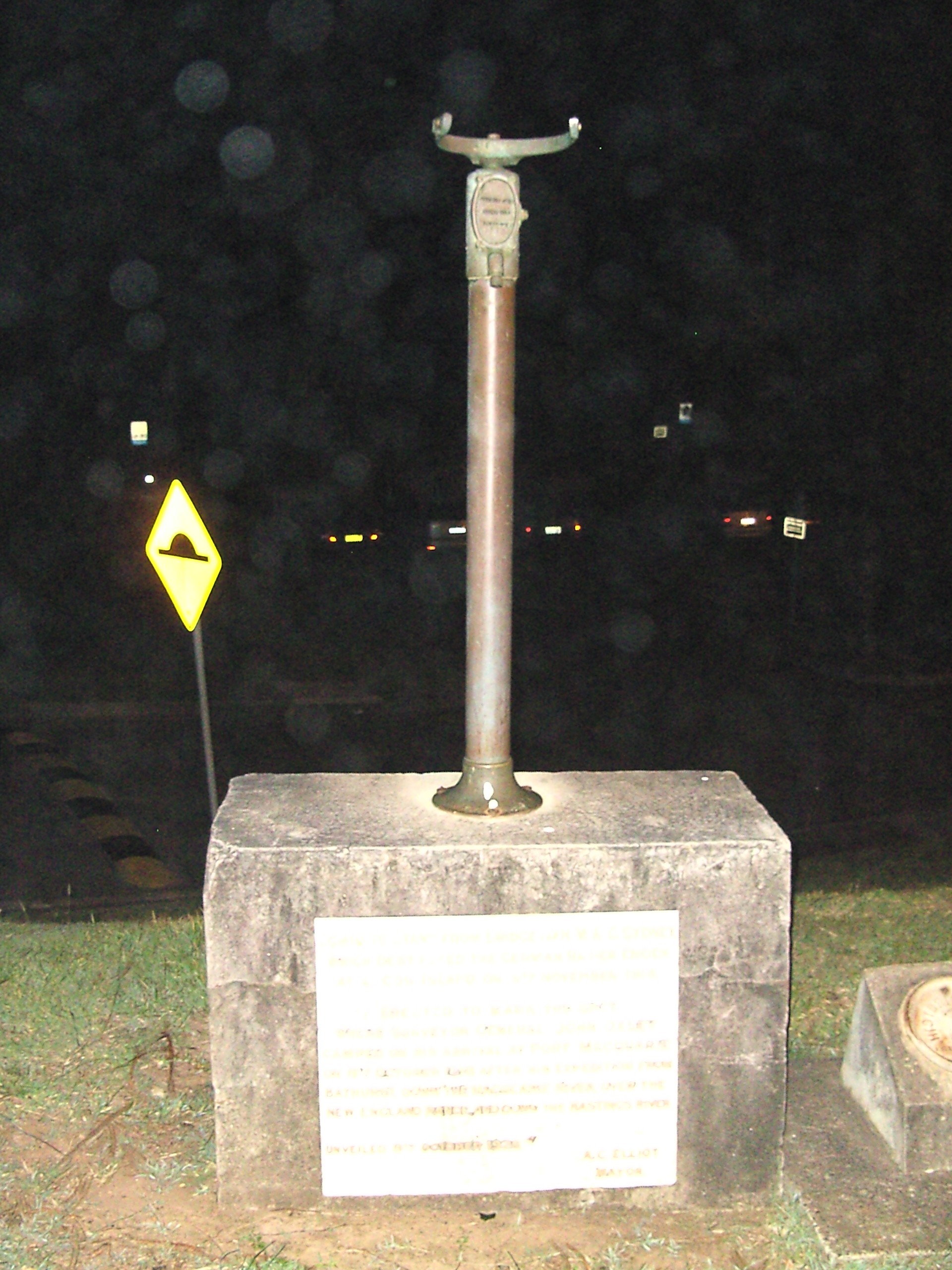 Compass stand from the bridge of HMAS Sydney, which destroyed the SMS Emden, installed at Port Macquarie, New South Wales, in 1929.
 -
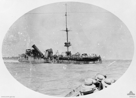 A broadside view of the wrecked Emden after her encounter with HMAS Sydney. Crew huddle on the wreck, awaiting rescue by Sydney.
 -
![The last bombing raid of World War II by 99, 356 and 321 Squadrons is cancelled, 15 August 1945.[81]](https://upload.wikimedia.org/wikipedia/commons/4/4f/BRIG_DURRANT_WRITING_CANCELLED.jpg) The last bombing raid of World War II by 99, 356 and 321 Squadrons is cancelled, 15 August 1945.[81]
The last bombing raid of World War II by 99, 356 and 321 Squadrons is cancelled, 15 August 1945.[81] -
 Queen Elizabeth and Prince Philip arrive at the Cocos Islands, April 1954.
 -
 Prince Philip waves goodbye as he and Queen Elizabeth, accompanied by John Clunies-Ross, return to their ship from Home Island (1954).
 -
 Queen Elizabeth at a garden party held in her honour at Home Island (1954).
_Islands_Airport_-_RWY33.jpg)
Islands_HomeIsland02.jpg)


![The last bombing raid of World War II by 99, 356 and 321 Squadrons is cancelled, 15 August 1945.[81]](/wiki/File:BRIG_DURRANT_WRITING_CANCELLED.jpg)


See also
- Banknotes of the Cocos (Keeling) Islands
- Index of Cocos (Keeling) Islands-related articles
- Pearl Islands (Isla de Cocos, Panama; Cocos Island, Costa Rica).
Notes
References
Citations
- ↑ 1.0 1.1 Template:Census 2016 AUS
- ↑ Lundy, Kate (2010). "Chapter 3: The economic environment of the Indian Ocean Territories". Inquiry into the changing economic environment in the Indian Ocean Territories (PDF). Parliament House, Canberra ACT: Joint Standing Committee on the National Capital and External Territories. p. 23. ISBN 978-0-642-79276-1.
- ↑ "List of left- & right-driving countries".
- ↑ "COCOS ISLANDS | Meaning & Definition for UK English | Lexico.com". Lexico Dictionaries | English. Retrieved 23 March 2022.
- ↑ Cocos Keeling Islands (11 February 2021). "Cocos Keeling Islands - Destination WA 2020 - Motorised Canoe Safari". YouTube. Retrieved 23 March 2022.
- ↑ "Cocos (Keeling) Islands". The World Factbook. CIA. Archived from the original on 12 September 2009. Retrieved 27 January 2012.
- ↑ 7.0 7.1 7.2 Woodroffe, C.D.; Berry, P.F. (February 1994). Scientific Studies in the Cocos (Keeling) Islands: An Introduction. Atoll Research Bulletin. Vol. 399. Washington DC: National Museum of Natural History. pp. 1–2. Archived from the original on 10 April 2016. Retrieved 26 August 2015.
- ↑ "Dynasties: Clunies-Ross". www.abc.net.au. Archived from the original on 31 August 2014. Retrieved 6 January 2016.
- ↑ Horsburgh, James (1841). "Islands to the Southward and South-eastward of Java; The Keeling or Cocos Islands". The India directory, or, Directions for sailing to and from the East Indies, China, Australia, and the interjacent ports of Africa and South America: comp. chiefly from original journals of the honourable company's ships, and from observations and remarks, resulting from the experience of twenty-one years in the navigation of those seas. Vol. 1 (5th ed.). London: W.H. Allen and Co. pp. 141–2.
- ↑ Ross, J. C. (May 1835). "The Cocos' Isles". The Metropolitan. Peck and Newton. p. 220.
- ↑ Weber, Max Carl Wilhelm; Weber, Lieven Ferdinand de Beaufort, Max Wilhelm Carl (1916). The Fishes of the Indo-australian Archipelago. Brill Archive. p. 286. Archived from the original on 31 December 2015. Retrieved 26 August 2015.
{{cite book}}: CS1 maint: multiple names: authors list (link) - ↑ "Photo of a sign".
- ↑ "Archived copy". Archived from the original on 11 January 2018. Retrieved 11 January 2018.
{{cite web}}: CS1 maint: archived copy as title (link) - ↑ "Climate statistics for Australian locations. Cocos Island Airport". Australian Bureau of Meteorology.
- ↑ Jupp, James; Jupp, Director Centre for Immigration and Multicultural Studies James (2001). The Australian People: An Encyclopedia of the Nation, Its People and Their Origins. Cambridge University Press. ISBN 978-0-521-80789-0.
- ↑ "2016 Census QuickStats: Cocos (Keeling) Islands". quickstats.censusdata.abs.gov.au.
- ↑ Nationaal Archief, The Hague, archive 4.VEL inventorynumber 338
- ↑ Pulu Keeling National Park Management Plan. Australian Government. 2004. ISBN 0-642-54964-8.
- ↑ "Gleanings in Science, Volume 2". Baptist Mission Press. 1830. Archived from the original on 31 December 2015. Retrieved 6 November 2015.
- ↑ 20.0 20.1 20.2 20.3 Joshua Slocum, "Sailing Alone Around the World", p. 212 Archived 26 December 2016 at the Wayback Machine
- ↑ The Clunies-Ross Chronicle Archived 5 September 2015 at the Wayback Machine
- ↑ Morning Post (London) 20 March 1835
- ↑ "BBC NEWS - Programmes - From Our Own Correspondent - The man who lost a 'coral kingdom'". Archived from the original on 27 September 2008. Retrieved 19 October 2008.
- ↑ Keynes, Richard (2001), Charles Darwin's Beagle Diary, Cambridge University Press, pp. 413–418, archived from the original on 26 December 2016, retrieved 20 January 2009
- ↑ 25.0 25.1 25.2 Commonwealth and Colonial Law by Kenneth Roberts-Wray, London, Stevens, 1966. p. 882
- ↑ "The Cocos Islands". The Chambers's Journal. 76: 187–190. 1899. Archived from the original on 31 December 2015. Retrieved 6 November 2015.
- ↑ S.R.O. & S.I. Rev. XXI, 512.
- ↑ S.R.O. 1903 No. 478, S.R.O. & S.I. Rev. XXI, 515
- ↑ 29.0 29.1 Commonwealth and Colonial Law by Kenneth Roberts-Wray, London, Stevens, 1966. p. 883
- ↑ "Timeline of major dates". Archived from the original on 15 December 2013. Retrieved 15 December 2013.
- ↑ McKay, S. 2012. The Secret Listeners. Aurum Press Ltd. ISBN 978 1 78131 079 3
- ↑ Cruise, Noel (2002). The Cocos Islands Mutiny. Fremantle: Fremantle Arts Centre Press. p. 248. ISBN 1-86368-310-0.
- ↑ "Imperial Submarines". Archived from the original on 21 September 2008. Retrieved 25 September 2008.
- ↑ Fail, J.E.H. "FORWARD STRATEGIC AIR BASE COCOS ISLAND". rquirk.com. Archived from the original on 7 February 2013. Retrieved 13 February 2013.
- ↑ Colony of Singapore. Government Gazette. (1 April 1946). The Singapore Colony Order in Council, 1946 (G.N. 2, pp. 2–3). Singapore: [s.n.]. Call no.: RCLOS 959.57 SGG; White paper on Malaya (26 January 1946). The Straits Times, p. 2. Retrieved from NewspaperSG; Tan, K. Y. L. (Ed.). (1999). The Singapore legal system (pp. 232–233). Singapore: Singapore University Press. Call no.: RSING 349.5957 SIN.
- ↑ 9 & 10 G. 6, c. 37
- ↑ Commonwealth and Colonial Law by Kenneth Roberts-Wray, London, Stevens, 1966. pp. 133–134
- ↑ Commonwealth and Colonial Law by Kenneth Roberts-Wray, London, Stevens, 1966. p. 134
- ↑ Stokes, Tony (2012). Whatever Will Be, I'll See: Growing Up in the 1940s, 50s and 60s in the Northern Territory, Christmas and the Cocos (Keeling) Islands, New South Wales and the Australian Capital Territory. Tony Stokes. p. 238. ISBN 9780646575643.
- ↑ Ken Mullen (1974). Cocos Keeling, the Islands Time Forgot. Sydney: Angus & Robertson. p. 122. ISBN 9780207131950. OCLC 1734040.
- ↑ "Cabinet papers: The last King of Cocos loses his palace". The Sydney Morning Herald. 30 December 2015. Archived from the original on 1 January 2016. Retrieved 1 January 2016.
- ↑ Kenneth Chen, "Pacific Island Development Plan: Cocos (Keeling) Islands- The Political Evolution of a Small Island Territory in the Indian Ocean" (1987): Mr Chen was Administrator, Cocos Islands, from December 1983 – November 1985.
- ↑ "Lost in transition". www.theaustralian.com.au. 31 August 2009. Archived from the original on 23 December 2016. Retrieved 27 December 2018.
- ↑ Herriman, Nicholas; Irving, David R.M.; Acciaioli, Greg; Winarnita, Monika; Kinajil, Trixie Tangit (25 June 2018). "A group of Southeast Asian descendants wants to be recognised as Indigenous Australians". The Conversation. Archived from the original on 26 July 2019. Retrieved 2 December 2019.
- ↑ WebLaw – full resource metadata display Archived 22 July 2008 at the Wayback Machine
- ↑ "Cocos (Keeling) Islands Act 1955". Archived from the original on 27 September 2007. Retrieved 5 November 2006.
- ↑ Department of Infrastructure, Transport, Regional Development and Local Government. "Territories of Australia". Archived from the original on 16 December 2007. Retrieved 7 February 2008.
As part of the Machinery of Government Changes following the Federal Election on 29 November 2007, administrative responsibility for Territories has been transferred to the Attorney General's Department.
{{cite web}}: CS1 maint: multiple names: authors list (link) - ↑ First Assistant Secretary, Territories Division (30 January 2008). "Territories of Australia". Attorney-General's Department. Archived from the original on 6 February 2008. Retrieved 7 February 2008.
The Federal Government, through the Attorney-General's Department administers Ashmore and Cartier Islands, Christmas Island, the Cocos (Keeling) Islands, the Coral Sea Islands, Jervis Bay, and Norfolk Island as Territories.
- ↑ "Commonwealth of Australia Administrative Arrangements Order made on 18 September 2013" (PDF). Australian Government Department of the Prime Minister and Cabinet. 18 September 2013. Archived from the original (PDF) on 14 October 2013.
- ↑ "Territories Law Reform Act 1992". Archived from the original on 7 July 2012. Retrieved 13 March 2012.
- ↑ 51.0 51.1 51.2 Birch, Laura (20 March 2022). "Indian Ocean marine parks off Christmas Island and Cocos Islands get the go-ahead". ABC News. Australian Broadcasting Corporation. Archived from the original on 26 March 2022. Retrieved 28 March 2022.
- ↑ 52.0 52.1
Senate polling places:
- Home Island Archived 19 January 2018 at the Wayback Machine
- Home Island PPVC Archived 19 January 2018 at the Wayback Machine
- West Island Archived 19 January 2018 at the Wayback Machine
- ↑ 53.0 53.1
House of Representatives polling places:
- Home Island Archived 19 January 2018 at the Wayback Machine
- Home Island PPVC Archived 19 January 2018 at the Wayback Machine
- West Island Archived 19 January 2018 at the Wayback Machine
- ↑ "Profile of the electoral division of Lingiari (NT)". Australian Electoral Commission. Archived from the original on 25 April 2016. Retrieved 2 May 2016.
- ↑ "2016 Defence White Paper (para. 4.66)" (PDF). defence.gov.au. Archived (PDF) from the original on 1 March 2016. Retrieved 26 February 2016.
- ↑ Jackson, Belinda (4 December 2016). "Cossies Beach, Cocos (Keeling) Islands: Beach expert Brad Farmer names Australia's best beach 2017". traveller.com.au. Fairfax Media. Archived from the original on 3 December 2016. Retrieved 4 December 2016.
- ↑ Bonnor, James (22 August 2016). "Australia appoints Brad Farmer to beach ambassador role". www.surfersvillage.com. XTreme Video. Archived from the original on 20 December 2016. Retrieved 4 December 2016.
- ↑ "Cocos (Keeling) Islands : Region Data Summary". Archived from the original on 15 October 2015. Retrieved 18 September 2015.
- ↑ Smee, Ben (16 May 2019). "414 million pieces of plastic found on remote island group in Indian Ocean". The Guardian. Retrieved 7 October 2019.
- ↑ "Significant plastic accumulation on the Cocos (Keeling) Islands, Australia". Scientific Reports. 9 (Article number 7102): 7102. 16 May 2019. Bibcode:2019NatSR...9.7102L. doi:10.1038/s41598-019-43375-4. PMC 6522509. PMID 31097730.
- ↑ McGrath, Matt (16 May 2019). "Plastic pollution: Flip-flop tide engulfs 'paradise' island". BBC News. Retrieved 7 October 2019.
- ↑ Kahn, Jo (17 May 2019). "Tonnes of plastic waste pollute Cocos Island beaches, and what you see is only a fragment". ABC News. Australian Broadcasting Corporation. Retrieved 7 October 2019.
- ↑ 63.0 63.1 Cogan, James, "US Marines begin operations in northern Australia Archived 16 April 2012 at the Wayback Machine." World Socialist Web Site, 14 April 2012.
- ↑ Whitlock, Craig, "U.S., Australia to broaden military ties amid Pentagon pivot to SE Asia Archived 9 February 2013 at Archive.today", The Washington Post, 26 March 2012.
- ↑ Grubel, James, "Australia open to US spy flights from Indian Ocean." Euronews, 28 March 2012. Archived 27 May 2012 at the Wayback Machine
- ↑ Whitlock, Craig (26 March 2012). "U.S., Australia announce deeper military ties amid Pentagon pivot to SE Asia". The Washington Post. Retrieved 9 December 2020.
- ↑ Hawley, Samantha. "Cocos Islands: US military base, not in our lifetime". abc.net.au. ABC. Retrieved 9 December 2020.
- ↑ "Logistics Group - Cocos Islands Cooperative Society Ltd". Cocoscoop.cc. Retrieved 19 February 2022.
- ↑ Kidman, Alex, "NBN To Launch Satellites in 2015 Archived 12 September 2012 at the Wayback Machine." Gizmodo, 8 February 2012.
- ↑ "SUB.CO - Submarine Cable Infrastructure Development Specialists". www.sub.co. Retrieved 22 June 2021.
- ↑ "Submarine Cable Map". www.submarinecablemap.com/. Retrieved 22 June 2021.
- ↑ "The Atoll Newsletter". Shire of Cocos Keeling Islands. Retrieved 13 August 2020.
- ↑ "List of licensed broadcasting transmitters". ACMA. Archived from the original on 11 February 2014. Retrieved 28 December 2013.
- ↑ Template:Cite AHD
- ↑ Conference, Museums Australia National (1997). Unlocking Museums: The Proceedings : 4th National Conference of Museums Australia Inc. Museums Australia. ISBN 978-0-949069-23-8.
- ↑ "Cocos (Keeling) Islands Shadow Puppets". Australia Post Collectables. Retrieved 4 September 2021.
- ↑ "Home Island | Cocos Keeling Islands". www.cocoskeelingislands.com.au. Retrieved 4 September 2021.
- ↑ RACWA. "Things To Do on Christmas Island and Cocos Keeling Islands | RAC WA". RAC WA - For a better WA. Retrieved 4 September 2021.
- ↑ "Cocos Museum". Commonwealth Walkway Trust. Retrieved 4 September 2021.
- ↑ "Budget 2021–22" (PDF). Government of Australia. 11 May 2021. Archived (PDF) from the original on 11 May 2021. Retrieved 20 September 2021.
- ↑ Maj-General J. T. Durrant (SA Air Force, Commanding Officer, Cocos Islands), watched by Wing Commander "Sandy" Webster (Commanding Officer, 99 Squadron), Squadron Leader Les Evans (Acting Commanding Officer, 356 Squadron) and Lieutenant Commander W. van Prooijen (Commanding Officer, 321 Squadron).
Sources
- Template:CIA World Factbook
- Clunies-Ross, John Cecil; Souter, Gavin. The Clunies-Ross Cocos Chronicle, Self, Perth 2009, ISBN 9780980586718.
- McGrath, Tony (2019). In Tropical Skies: A History of Aviation to Christmas Island and Cocos (Keeling) Islands. Carlisle, WA: Hesperian Press. ISBN 9780859057561.
External links
- Shire of Cocos (Keeling) Islands homepage
- Areas of individual islets
- Atoll Research Bulletin vol. 403
- Cocos (Keeling) Islands Tourism website
- Noel Crusz, The Cocos Islands mutiny, reviewed by Peter Stanley (Principal Historian, Australian War Memorial).
- The man who lost a "coral kingdom"
- Amateur Radio DX Pedition to Cocos (Keeling) Islands VK9EC


| |||||||||||||||||||||||||||||||||||||||||||||