.svg)
Rupin Pass: Difference between revisions
No edit summary |
No edit summary |
||
| Line 12: | Line 12: | ||
| location = [[India]] | | location = [[India]] | ||
}} | }} | ||
'''Rupin Pass''' is a high altitude [[Mountain pass|pass]] across the [[Himalaya]] mountain range in state of | '''Rupin Pass''' is a high altitude [[Mountain pass|pass]] across the [[Himalaya]] mountain range in state of Himachal pradesh [[India]]. It lies on a traditional shepherd and [[hiking]] route which starts from [[Dhaula]] in [[Uttarakhand]] and ends in [[Sangla, India|Sangla]] in [[Himachal Pradesh]]. The path itself is located across mostly uninhabited areas in the Himalayan ranges at an elevation of 15,250 ft (4,650M) above sea level.<ref name="Cunningham 1854 p. 71" /> '''Sarasvati Glacier''' at '''Sarasvotri''' at this pass has been identified by some sources as the origin of paleo-river [[Sarasvati River|Sarasvati]] which turned in to icy waters at Netwar, flowing through [[Paonta Sahib]] and [[Adi Badri, Haryana|Adi Badri]], [[Haryana]], [[Punjab, India|Punjab]], [[Rajasthan]] and [[Gujarat]].<ref name=sarasnew1>[http://haryanasamvad.gov.in/store/document/11%2012%201%20HARYANA%20SAMVAD%20NOV-%20JAN%202017-2018%20FOR%20for%20web.pdf Haryana Samvad], Jan 2018.</ref> | ||
== Description == | == Description == | ||
| Line 50: | Line 50: | ||
{{Commons category|Rupin Pass}} | {{Commons category|Rupin Pass}} | ||
* [https://web.archive.org/web/20101228045836/http://picasaweb.google.com/indiahikes.wintercamp/RupinPassTrek#5436475002989491170 Photo sets of Rupin Pass] | * [https://web.archive.org/web/20101228045836/http://picasaweb.google.com/indiahikes.wintercamp/RupinPassTrek#5436475002989491170 Photo sets of Rupin Pass] | ||
{{Mountain passes of India}} | {{Mountain passes of India}} | ||
[[Category:Mountain passes of Himachal Pradesh]] | [[Category:Mountain passes of Himachal Pradesh]] | ||
[[Category:Geography of Kinnaur district]] | [[Category:Geography of Kinnaur district]] | ||
Latest revision as of 10:13, 23 December 2021
Template:Infobox mountain pass Rupin Pass is a high altitude pass across the Himalaya mountain range in state of Himachal pradesh India. It lies on a traditional shepherd and hiking route which starts from Dhaula in Uttarakhand and ends in Sangla in Himachal Pradesh. The path itself is located across mostly uninhabited areas in the Himalayan ranges at an elevation of 15,250 ft (4,650M) above sea level.[1] Sarasvati Glacier at Sarasvotri at this pass has been identified by some sources as the origin of paleo-river Sarasvati which turned in to icy waters at Netwar, flowing through Paonta Sahib and Adi Badri, Haryana, Punjab, Rajasthan and Gujarat.[2]
Description[edit]
Rupin Pass trek consists of trails dug out of rock faces and wooden bridges, cut through deep dark folds in the mountain, glaciers and icy slopes, and over snow fields. Along the way there are white Rhododendrons and expanse of green meadows.
There are different trails that access the Rupin Pass. One of them starts at the sleepy village of Gosangu which is the last road head of Himachal Pradesh. Generally, trekkers and adventurers travel to Gosangu by road from Shimla via Rohru. The alternate route to Rupin Pass starts from Naitwar, which is accessible from Dehradhun via Dhaula. From either of the two road heads, the first camp is Jhaka, the hanging village and the last stop for replenishing stocks and a look at the civilization. Traveling the Rupin Pass is a moderate – difficult level of climbing. The trails follow the Rupin river all the way to the top (Upper waterfall camp).
Rupin pass is unique in a way that the ice melting on the one side of the pass forms the Rupin river that merges with Yamuna and eventually flows into the Bay of Bengal while the snow melting on the Sangla side of the pass merges into a stream the eventually flow into Sutlaj and hence flows into the Arabian sea.
Access[edit]
Rupin pass is at an altitude of 15250 ft above MSL and to reach here follow the Dhaula 5,100 ft to Gosangu 6,300 ft.11 km. Via Sewa – Gosangu 6,300 ft to Jhaka 8,700 ft.9 km Via Jiskun 7,600 ft. - Jhaka 8,700 ft to Saruwas thatch 11,150 ft. 6 km. Via Uduknal – Saruwas thatch 11,150 ft to thatch 11,680 ft (lower water fall camp) 6 km. - thatch 11,680 ft to the top of the Rupin waterfall 13,120 ft – thatch 11,680 ft to Rupin pass 15,250 ft
Gallery[edit]
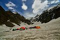
View of Rupin Waterfall

View of the valley from Rupin waterfall en route to Rupin Pass

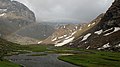

View of the Meadows in Rupin Pass


References[edit]
- ↑ Cunningham, A. (1854). Ladák ... with notices of the surrounding countries. p. 71. Retrieved 13 June 2018.
- ↑ Haryana Samvad, Jan 2018.