Zingzingbar: Difference between revisions
imported>Encodedkamal m (Added image) |
->MPGuy2824 (removed hindi per MOS:INDICSCRIPT) |
||
| Line 4: | Line 4: | ||
{{Infobox settlement | {{Infobox settlement | ||
| name = Zingzingbar | | name = Zingzingbar | ||
| other_name = Zing Zing Bar | | other_name = Zing Zing Bar | ||
| settlement_type = camp, way-station | | settlement_type = camp, way-station | ||
| image_skyline = View of Zingzingbar.jpg | | image_skyline = View of Zingzingbar.jpg | ||
| image_alt = | | image_alt = View of Zingzingbar | ||
| image_caption = | | image_caption = View of Zingzingbar | ||
| pushpin_map = India Himachal Pradesh#India | | pushpin_map = India Himachal Pradesh#India | ||
| pushpin_label_position = right | | pushpin_label_position = right | ||
| pushpin_map_alt = | | pushpin_map_alt = Location in Himachal Pradesh, India | ||
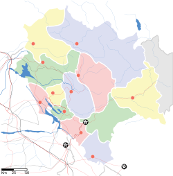
| pushpin_map_caption = Location in Himachal Pradesh, India | | pushpin_map_caption = Location in Himachal Pradesh, India | ||
| coordinates = {{coord|32.7918924|N|77.3245239|E|display=inline,title}} | | coordinates = {{coord|32.7918924|N|77.3245239|E|display=inline,title}} | ||
| Line 23: | Line 20: | ||
| subdivision_type2 = [[List of districts of India|District]] | | subdivision_type2 = [[List of districts of India|District]] | ||
| subdivision_name2 = [[Lahaul and Spiti district|Lahaul and Spiti]] | | subdivision_name2 = [[Lahaul and Spiti district|Lahaul and Spiti]] | ||
| unit_pref = Metric | | unit_pref = Metric | ||
| elevation_m = 4270 | | elevation_m = 4270 | ||
| utc_offset1 = +5:30 | | utc_offset1 = +5:30 | ||
}} | }} | ||
Latest revision as of 14:23, 14 September 2021
Zingzingbar
Zing Zing Bar | |
|---|---|
camp, way-station | |
 View of Zingzingbar | |
| Coordinates: 32°47′31″N 77°19′28″E / 32.7918924°N 77.3245239°ECoordinates: 32°47′31″N 77°19′28″E / 32.7918924°N 77.3245239°E | |
| Country | |
| State | Himachal Pradesh |
| District | Lahaul and Spiti |
| Elevation | 4,270 m (14,010 ft) |
| Time zone | UTC+5:30 |
Zingzingbar is a Border Roads Organization road-building camp and tea house way-station situated 25 kilometres (16 mi) from Darcha on the Manali to Leh road in the Lahaul and Spiti district of Himachal Pradesh. It is situated at an altitude of around 14,010 feet (4,270 m). The location has temporary shelters and dhabas that can be used by trekkers and tourists for accommodation.[1]
Zingzingbar is the proposed south portal of the Bara-lacha-la tunnel,[2] situated approximately 125 kilometres (78 mi) from Manali. The north portal of this tunnel is expected to be at Keylong Sarai. The tunnel will reduce the transit time on the avalanche and landslide prone route by up to 2 hrs.[3]
References[edit]
- ↑ Deshmukh, Vivek (19 October 2019). "Day 4—Manali to Leh cycling expedition". Medium. Retrieved 7 October 2020.
- ↑ Service, Tribune News. "BRO sets ball rolling for tunnel under Baralacha". Tribuneindia News Service. Retrieved 7 October 2020.
- ↑ Service, Tribune News. "Road inundated, traffic disrupted on Manali NH". Tribuneindia News Service. Retrieved 7 October 2020.

