


imported>Normal Name m Fixed typo detected by Wikipedia: Typo Team/moss, taxs --> taxes |
->C1MM Corrected language data |
||
| Line 1: | Line 1: | ||
{{Short description|Division of Jharkhand, India}} | |||
{{Use dmy dates|date=July 2019}} | {{Use dmy dates|date=July 2019}} | ||
{{Refimprove|date=August 2016}} | {{Refimprove|date=August 2016}} | ||
{{Infobox settlement | |||
| name = Santhal Pargana division | |||
| native_name = | |||
| image_map = Santhal Pargana division.png | |||
| map_caption = Location of Santhal Pargana in Jharkhand | |||
| coordinates = {{coord|24|30|N|87|30|E|region:IN_type:adm2nd|display=inline,title}} | |||
| subdivision_type = Country | |||
| subdivision_name = {{flag|India}} | |||
| subdivision_type1 = State | |||
| subdivision_name1 = [[Jharkhand]] | |||
| established_title = Established | |||
| established_date = | |||
| seat_type = Headquarters | |||
| seat = [[Dumka]] | |||
| parts_type = Districts | |||
| parts_style = para | |||
| p1 = [[Godda district]] | |||
| leader_title = Commissioner | |||
| leader_name = Shri Chandra Mohan Prasad Kashyap, I.A.S | |||
| area_total_km2 = 12,601 | |||
| population_total = 69,69,097 | |||
| population_as_of = 2011 | |||
| website = | |||
| type = Division of [[Jharkhand]] | |||
| p2 = [[Deoghar district | Deoghar]] | |||
| p3 = [[Dumka district | Dumka]] | |||
| p4 = [[Jamtara district | Jamtara]] | |||
| p5 = [[Sahibganj district | Sahibganj]] | |||
| p6 = [[Pakur district | Pakur]] | |||
| population_density_km2 = auto | |||
}} | |||
'''Santhal Pargana division''' constitutes one of the five district administration units known as the divisions of [[Jharkhand]] state in eastern [[India]]. | |||
==Origin of name== | ==Origin of name== | ||
[[File:1907-bengal-sikkim3.jpg|thumb|The [[Santal Parganas]] in a 1907 map of the Bengal area]] | [[File:1907-bengal-sikkim3.jpg|thumb|The [[Santal Parganas]] in a 1907 map of the Bengal area]] | ||
| Line 9: | Line 41: | ||
==Location== | ==Location== | ||
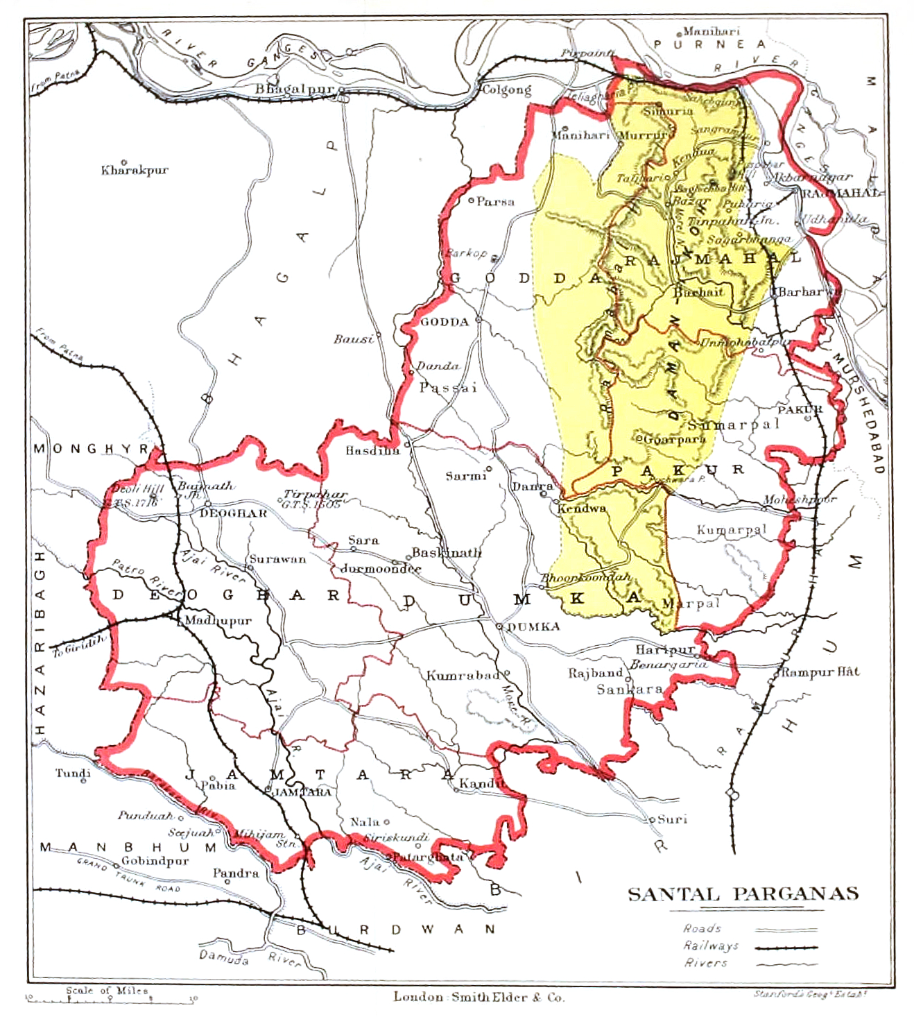
Santhal Pargana is one of the divisions of [[Jharkhand]]. Its headquarters is at [[Dumka]]. Presently, this administrative division comprises six districts: [[Godda district|Godda]], [[Deoghar district|Deoghar]], [[Dumka district|Dumka]], [[Jamtara district|Jamtara]], [[Sahebganj district|Sahibganj]] and [[Pakur district|Pakur]]. | Santhal Pargana is one of the divisions of [[Jharkhand]]. Its headquarters is at [[Dumka]]. Presently, this administrative division comprises six districts: [[Godda district |Godda]], [[Deoghar district|Deoghar]], [[Dumka district|Dumka]], [[Jamtara district|Jamtara]], [[Sahebganj district|Sahibganj]] and [[Pakur district|Pakur]]. | ||
[[File:Santal_Parganas.jpg|thumb|Boundary map (1905)]] | [[File:Santal_Parganas.jpg|thumb|Boundary map (1905)]] | ||
| Line 16: | Line 48: | ||
It is mentioned that the Chinese monk-traveller [[Xuanzang]] (Hiuen Tsang) travelled from Champa (recent [[Bhagalpur]]) to Kajangala and then proceeded to [[Pundravardhana]] (recent [[Bangladesh]]) in the 7th century AD. He says that the northern limit of its territory (means [[Sahebganj]]) was not very far from the [[Ganges]]. The forests to the south had plenty of [[elephant]]s. The people were straight forward, talented and devoted to education.<ref name = "Roy">Roy, Niharranjan, ''Bangalir Itihas, Adi Parba'', {{in lang|bn}}, first published 1972, reprint 2005, pp. 99-100, 81-93, Dey’s Publishing, 13 Bankim Chatterjee Street, Kolkata, {{ISBN|81-7079-270-3}}</ref> | It is mentioned that the Chinese monk-traveller [[Xuanzang]] (Hiuen Tsang) travelled from Champa (recent [[Bhagalpur]]) to Kajangala and then proceeded to [[Pundravardhana]] (recent [[Bangladesh]]) in the 7th century AD. He says that the northern limit of its territory (means [[Sahebganj]]) was not very far from the [[Ganges]]. The forests to the south had plenty of [[elephant]]s. The people were straight forward, talented and devoted to education.<ref name = "Roy">Roy, Niharranjan, ''Bangalir Itihas, Adi Parba'', {{in lang|bn}}, first published 1972, reprint 2005, pp. 99-100, 81-93, Dey’s Publishing, 13 Bankim Chatterjee Street, Kolkata, {{ISBN|81-7079-270-3}}</ref> | ||
In the system of [[Permanent Settlement]], British encourage [[Sauria Paharia people|paharia]] of [[Rajmahal hills]] to practice settled agriculture but they refused to cut trees. Then British officials attracted attention to Santals who were ready to clear the forests for settled agriculture. In 1832, a large number of area demarcated as [[Damin-i-koh]] or | In the system of [[Permanent Settlement]], British encourage [[Sauria Paharia people|paharia]] of [[Rajmahal hills]] to practice settled agriculture but they refused to cut trees. Then British officials attracted attention to Santals who were ready to clear the forests for settled agriculture. In 1832, a large number of area demarcated as [[Damin-i-koh]] or Santal Pargana. The land was declared as the land of Santal. Santal from [[Cuttack]], [[Dhalbhum]], [[Birbhum]], [[Manbhum]], [[Hazaribagh]] migrated and started cultivating these lands as peasants. British collected tax from Santals as revenue. The imposition of taxes, exploitation by [[Zamindar]] and money lenders sparked Santal rebellion. The [[Sidhu and Kanhu Murmu]], two brothers led the Santals against the Britishers but were defeated.<ref>{{Cite journal|last=Jha|first=Amar Nath|title=Locating the Ancient History of Santal Parganas|date=2009|journal=Proceedings of the Indian History Congress|volume=70|pages=185–196|issn=2249-1937|jstor=44147668}}</ref><ref>{{Cite book|url=https://books.google.com/books?id=9T3zYvKVF98C&q=santhal&pg=PA57|title=This is Our Homeland: A Collection of Essays on the Betrayal of Adivasi|year=2007|access-date= 26 August 2019}}</ref><ref>{{Cite book|url=https://books.google.com/books?id=bMg-DAAAQBAJ&q=santhal+revolt&pg=PA329|title=History of India|isbn=9788173354984|access-date=26 August 2019|last1=Malik|first1=Dr Malti|year=1943}}</ref><ref>http://sahibganj.nic.in/en/History.html</ref><ref>{{Cite web|url=http://wesanthals.tripod.com/id50.html|title = Freedom Struggle}}</ref> | ||
[[File:Attack by 600 Santhals upon a party of 50 sepoys, 40th regiment native infantry.jpg|thumb|Attack by 600 Santhals upon a party of 50 sepoys, 40th regiment native infantry]] | [[File:Attack by 600 Santhals upon a party of 50 sepoys, 40th regiment native infantry.jpg|thumb|Attack by 600 Santhals upon a party of 50 sepoys, 40th regiment native infantry]] | ||
Formerly, Santhal Parganas comprised a district of the same name, in undivided [[Bihar]] state, India. Earlier to that, in 1855, during [[British India]], Santhal Parganas was created as a district, and was a part of the [[Bengal Presidency]]. | Formerly, Santhal Parganas comprised a district of the same name, in undivided [[Bihar]] state, India. Earlier to that, in 1855, during [[British India]], Santhal Parganas was created as a district, and was a part of the [[Bengal Presidency]]. | ||
==Languages== | ==Languages== | ||
{{pie chart | |||
|thumb=right | |||
|caption=Languages in Santhal Parganas division (2011)<ref>{{cite web|url=http://www.censusindia.gov.in/2011census/C-16.html|title=Census of India Website : Office of the Registrar General & Census Commissioner, India|website=www.censusindia.gov.in}}</ref> | |||
|label1 = [[Khortha language|Khotta]]|value1 = 29.11 |color1 = red | |||
|label2 = [[Santali language|Santali]] |value2 = 24.25 |color2 = blue | |||
|label3 = [[Bengali language|Bengali]] |value3 = 16.11 |color3 = gold | |||
|label4 = [[Angika]] |value4 = 10.40 |color4 = moccasin | |||
|label5 = [[Hindi]] |value5 = 8.69 |color5 = orange | |||
|label6 = [[Urdu]] |value6 = 5.06 |color6 = green | |||
|label7 = [[Malto language|Malto]] |value7 = 2.15 |color7 = magenta | |||
|label8 = [[Bhojpuri language|Bhojpuri]] |value8 = 1.99 |color8 = lightsalmon | |||
|label9 = Others |value9 =2.24 |color9 = gray | |||
}} | |||
It has a population of 6,969,097. | |||
==Religion== | |||
{{ pie chart | {{ pie chart | ||
|thumb=right | |thumb=right | ||
|caption= | |caption=Religions in Santhal Parganas 2011 census | ||
|label1 = | |label1 = Hindus |value1 = 67.95 |color1 = darkorange | ||
|label2 = | |label2 = Muslims |value2 = 22.73 |color2 = green | ||
|label3 = | |label3 = Christians |value3 = 4.21|color3 = blue | ||
|label4 = | |label4 = Sarna |value4 = 4.84|color4 = red | ||
|label5 = | |label5 = Others |value5 = 0.27|color5 = Grey | ||
}} | }} | ||
==References== | ==References== | ||
{{reflist}} | {{reflist}} | ||
{{Santhal Pargana Division topics}} | {{Santhal Pargana Division topics}} | ||
Revision as of 07:57, 30 December 2021
 | This article needs additional citations for verification. (August 2016) |
Santhal Pargana division | |
|---|---|
Division of Jharkhand | |
 Location of Santhal Pargana in Jharkhand | |
| Coordinates: 24°30′N 87°30′E / 24.500°N 87.500°E | |
| Country |  India India |
| State | Jharkhand |
| Headquarters | Dumka |
| Districts | Godda district, Deoghar, Dumka, Jamtara, Sahibganj, Pakur |
| Government | |
| • Commissioner | Shri Chandra Mohan Prasad Kashyap, I.A.S |
| Area | |
| • Total | 12,601 km2 (4,865 sq mi) |
| Population (2011) | |
| • Total | 6,969,097 |
| • Density | 550/km2 (1,400/sq mi) |
Santhal Pargana division constitutes one of the five district administration units known as the divisions of Jharkhand state in eastern India.
Origin of name

Santhal Pargana derives its name from two words: "Santhal", a major tribe of India and Pargana, a unit of administration used mostly by medieval rulers.
Location
Santhal Pargana is one of the divisions of Jharkhand. Its headquarters is at Dumka. Presently, this administrative division comprises six districts: Godda, Deoghar, Dumka, Jamtara, Sahibganj and Pakur.

History
This region is mentioned as Kajangala in different ancient literatures specially in Buddhist literatures. It is mentioned that the Chinese monk-traveller Xuanzang (Hiuen Tsang) travelled from Champa (recent Bhagalpur) to Kajangala and then proceeded to Pundravardhana (recent Bangladesh) in the 7th century AD. He says that the northern limit of its territory (means Sahebganj) was not very far from the Ganges. The forests to the south had plenty of elephants. The people were straight forward, talented and devoted to education.[1]
In the system of Permanent Settlement, British encourage paharia of Rajmahal hills to practice settled agriculture but they refused to cut trees. Then British officials attracted attention to Santals who were ready to clear the forests for settled agriculture. In 1832, a large number of area demarcated as Damin-i-koh or Santal Pargana. The land was declared as the land of Santal. Santal from Cuttack, Dhalbhum, Birbhum, Manbhum, Hazaribagh migrated and started cultivating these lands as peasants. British collected tax from Santals as revenue. The imposition of taxes, exploitation by Zamindar and money lenders sparked Santal rebellion. The Sidhu and Kanhu Murmu, two brothers led the Santals against the Britishers but were defeated.[2][3][4][5][6]

Formerly, Santhal Parganas comprised a district of the same name, in undivided Bihar state, India. Earlier to that, in 1855, during British India, Santhal Parganas was created as a district, and was a part of the Bengal Presidency.
Languages
It has a population of 6,969,097.
Religion
Religions in Santhal Parganas 2011 census
References
- ↑ Roy, Niharranjan, Bangalir Itihas, Adi Parba, (in Bengali), first published 1972, reprint 2005, pp. 99-100, 81-93, Dey’s Publishing, 13 Bankim Chatterjee Street, Kolkata, ISBN 81-7079-270-3
- ↑ Jha, Amar Nath (2009). "Locating the Ancient History of Santal Parganas". Proceedings of the Indian History Congress. 70: 185–196. ISSN 2249-1937. JSTOR 44147668.
- ↑ This is Our Homeland: A Collection of Essays on the Betrayal of Adivasi. 2007. Retrieved 26 August 2019.
- ↑ Malik, Dr Malti (1943). History of India. ISBN 9788173354984. Retrieved 26 August 2019.
- ↑ http://sahibganj.nic.in/en/History.html
- ↑ "Freedom Struggle".
- ↑ "Census of India Website : Office of the Registrar General & Census Commissioner, India". www.censusindia.gov.in.
 | This article related to a location in Jharkhand is a stub. You can help Bharatpedia by expanding it. |