
m robot: Create/upgrade articles. If there is a mistake please report on my talk page. |
WikiDwarfBOT (talk | contribs) Cleanup: Source modification. |
||
| Line 1: | Line 1: | ||
{{Use dmy dates|date=May | {{Use dmy dates|date=May 2018}} | ||
{{Use Indian English|date=May | {{Use Indian English|date=May 2018}} | ||
{{tone|date=January | {{tone|date=January 2015}} | ||
{{Infobox settlement | {{Infobox settlement | ||
| name = | | name = Pachmarhi | ||
| official_name = | | official_name = | ||
| other_name = | | other_name = | ||
| Line 13: | Line 13: | ||
| map_alt = | | map_alt = | ||
| map_caption = | | map_caption = | ||
| pushpin_map = India Madhya Pradesh# | | pushpin_map = India Madhya Pradesh#India | ||
| pushpin_label_position = right | | pushpin_label_position = right | ||
| pushpin_map_alt = | | pushpin_map_alt = | ||
| Line 23: | Line 23: | ||
| subdivision_name1 = [[Madhya Pradesh]] | | subdivision_name1 = [[Madhya Pradesh]] | ||
| subdivision_type2 = [[List of districts of India|District]] | | subdivision_type2 = [[List of districts of India|District]] | ||
| subdivision_name2 = [[Narmadapuram]] | | subdivision_name2 = [[Narmadapuram district|Narmadapuram]] | ||
| established_title = <!-- Established --> | | established_title = <!-- Established --> | ||
| established_date = | | established_date = | ||
| Line 57: | Line 57: | ||
| footnotes = | | footnotes = | ||
}} | }} | ||
It is widely known as ''Satpura ki Rani'' ("Queen of [[Satpura]]"), situated at | '''Pachmarhi''' is a [[hill station]] in the [[Narmadapuram district]] of [[Madhya Pradesh]] [[states and territories of India|state]] of central [[India]]. It has been the location of a [[cantonment]] (Pachmarhi Cantonment) since [[British Raj]].<ref>{{Cite web |title=Pachmarhi, Jewel in the crown of Central India |website=[[Times of India]] |url=http://timesofindia.indiatimes.com/life-style/travel/Pachmarhi-Jewel-in-the-crown-of-Central-India/articleshow/26951719.cms |access-date=2021-12-25 |archive-date=13 December 2013 |archive-url=https://web.archive.org/web/20131213053808/http://timesofindia.indiatimes.com/life-style/travel/Pachmarhi-Jewel-in-the-crown-of-Central-India/articleshow/26951719.cms |url-status=live }}</ref> | ||
It is widely known as ''Satpura ki Rani'' ("Queen of [[Satpura]]"), situated at the height of 1067 m in a valley of the [[Satpura Range]] in the [[Narmadapuram district]]. [[Dhupgarh]], the highest point (1,352 m) in [[Madhya Pradesh]] and the [[Satpura]] range, is located here. It is a part of the Satpura Biosphere Reserve. It is also famous for the [[Satpura Tiger Reserve]], Satpura National Park, [[Lord Shiva]] and the [[Pandava]]s of [[Mahabharata]]. | |||
==History== | ==History== | ||
The name Pachmarhi is believed to be derived from the Hindi words ''Panch'' ("five") and ''Marhi'' ("caves"). According to a legend, these caves were built by five [[Pandava]] brothers of [[Mahabharatha]] era during their thirteen years of exile. The caves are situated on a hilltop and provide an excellent vantage point. | The name Pachmarhi is believed to be derived from the Hindi words ''Panch'' ("five") and ''Marhi'' ("caves"). According to a legend, these caves were built by five [[Pandava]] brothers of [[Mahabharatha]] era during their thirteen years of exile.{{Citation needed|date=July 2023|reason=The article claims there is a legend about how the caves originated, but does not back this up with evidence.}} The caves are situated on a hilltop and provide an excellent vantage point. | ||
Pachmadhi region was Ruled by Bhonsale Kings।. It came under Marathas in 18th | Pachmadhi region was Ruled by Bhonsale Kings।. It came under Marathas in the 18th century under SenaSahebSubha Maharaj Raghuji Raje Bhonsale।. | ||
Before the [[British Raj|British]], the Pachmarhi region was under the kingdom of the [[Gondi people|Gond]] Bhagvat Singh, although it was not a populated village or town at that time. Captain James Forsyth of the [[British Army]] along with Subhedar Major Nathoo Ramji Powar who was later made the Kotwal (in charge of the armoury) | Before the [[British Raj|British]], the Pachmarhi region was under the kingdom of the [[Gondi people|Gond]] Bhagvat Singh, although it was not a populated village or town at that time. Captain James Forsyth of the [[British Army]] along with Subhedar Major Nathoo Ramji Powar, who was later made the Kotwal (in charge of the armoury) of Pachmarhi, spotted the plateau in the Pachmarhi region in 1857 while leading his troops on the way to [[Jhansi]].<ref>{{cite book | title=Pachmarhi Travel Guide | url=https://books.google.com/books?id=1B4rvdpvS7YC&pg=PA6 | year=2009 | publisher=Goodearth Publications | isbn=978-81-87780-95-3 | pages=6 | access-date=5 October 2016 | archive-date=14 February 2017 | archive-url=https://web.archive.org/web/20170214220418/https://books.google.com/books?id=1B4rvdpvS7YC&pg=PA6 | url-status=live }}</ref> It quickly developed into [[hill station]] and [[sanatorium]] for British troops in the [[Central Provinces]] of India. | ||
The population in 1901 was 3,020, rising to double that number in the hot summer months. Pachmarhi also served as the [[summer capital]] for the [[Central Provinces]]. | The population in 1901 was 3,020, rising to double that number in the hot summer months. Pachmarhi also served as the [[summer capital]] for the [[Central Provinces]]. | ||
| Line 72: | Line 73: | ||
The forest around the town is home to many rare varieties of plants. [[UNESCO]] added Pachmarhi park to its list of [[Biosphere Reserve]]s in May 2009. | The forest around the town is home to many rare varieties of plants. [[UNESCO]] added Pachmarhi park to its list of [[Biosphere Reserve]]s in May 2009. | ||
The total area of Pachmarhi Biosphere Reserve is 4981.72 km<sup>2</sup>. It is located at longitude 22° 11’ to 22° 50’N and latitude 77° 47’ to 78° 52’E. It covers parts of three civil districts, viz; | The total area of [[Pachmarhi Biosphere Reserve]] is 4981.72 km<sup>2</sup>. It is located at longitude 22° 11’ to 22° 50’N and latitude 77° 47’ to 78° 52’E. It covers parts of three civil districts, viz; Narmadapuram (59.55%), Chhindwara (29.19%) and Betul (11.26%). It includes three wildlife conservation units viz., Bori Sanctuary 485.72 km<sup>2</sup>), Satpura National Park (524.37 km<sup>2</sup>) and Pachmarhi Sanctuary (491.63 km<sup>2</sup>).<ref name="sify-br">{{cite news|url=http://sify.com/news/fullstory.php?a=jf1u4rjejdc&title=Three_Indian_sites_added_to_UNESCO_list_of_biosphere_reserves|title=Three Indian sites added to UNESCO list of biosphere reserves|date=27 May 2009|website=[[Sify]]|access-date=2009-05-30|archive-url=https://web.archive.org/web/20141028175430/http://www.sify.com/news/fullstory.php?a=jf1u4rjejdc&title=Three_Indian_sites_added_to_UNESCO_list_of_biosphere_reserves|archive-date=28 October 2014|url-status=dead}}</ref><ref name="ens">{{cite news|url=http://www.ens-newswire.com/ens/may2009/2009-05-27-01.asp|title=UNESCO Designates 22 New Biosphere Reserves|date=27 May 2009|publisher=Environment News Service|access-date=2009-05-30|archive-date=3 March 2016|archive-url=https://web.archive.org/web/20160303175759/http://www.ens-newswire.com/ens/may2009/2009-05-27-01.asp|url-status=dead}}</ref> | ||
==Town== | ==Town== | ||
The town is | The town is small and most of its area is under the administration of the Pachmarhi Cantonment Board, serving the [[Indian Army]]. It is the center of the [[Army Education Corps (India)|Army Education Corps (AEC)]]. The population of Pachmarhi is about 12,062 as per the report released by Census India 2011, most of whom are connected with the Army installations, tourism, and forest department. | ||
An airstrip is situated on the way to [[Dhupgarh]]. It is overrun with grass and is seldom used. Tigers and bison are known to have been sighted nearby. A helipad is also present near the airstrip. Leopard sightings are also common along the edge of the Pachmarhi Cantonment. | |||
==Climate== | ==Climate== | ||
The climate is mild, with temperatures ranging from warm to cool. Summers have significantly more rainfall than winters. Köppen and Geiger classify this location as Cwa. The average temperature in this area is 21.7 °C. The average rainfall in this area is 2012 mm. May is the hottest month of the year, with an average temperature of 30.3 °C. December is the coldest month of the year, with an average temperature of 15.5 °C.<ref name=CDO>{{Cite web|title=Pachmarhi climate: Average Temperature, weather by month, Pachmarhi weather averages - Climate-Data.org|url=https://en.climate-data.org/asia/india/madhya-pradesh/pachmarhi-796784/|access-date=2021-12-25|website=en.climate-data.org|archive-date=22 June 2019|archive-url=https://web.archive.org/web/20190622113832/https://en.climate-data.org/asia/india/madhya-pradesh/pachmarhi-796784/|url-status=live}}</ref> | The climate is mild, with temperatures ranging from warm to cool. Summers have significantly more rainfall than winters. [[Köppen climate classification|Köppen]] and Geiger classify this location as Cwa. The average temperature in this area is 21.7 °C. The average rainfall in this area is 2012 mm. May is the hottest month of the year, with an average temperature of 30.3 °C. December is the coldest month of the year, with an average temperature of 15.5 °C.<ref name=CDO>{{Cite web|title=Pachmarhi climate: Average Temperature, weather by month, Pachmarhi weather averages - Climate-Data.org|url=https://en.climate-data.org/asia/india/madhya-pradesh/pachmarhi-796784/|access-date=2021-12-25|website=en.climate-data.org|archive-date=22 June 2019|archive-url=https://web.archive.org/web/20190622113832/https://en.climate-data.org/asia/india/madhya-pradesh/pachmarhi-796784/|url-status=live}}</ref> | ||
{{Weather box <!--Infobox begins--> | {{Weather box <!--Infobox begins--> | ||
| Line 157: | Line 158: | ||
==Tourism== | ==Tourism== | ||
{{Unreferenced section|date=May | {{Unreferenced section|date=May 2017}} | ||
[[File:Pachmarhi.jpg|thumb|right|250px|Pandav Caves Pachmarhi]] | [[File:Pachmarhi.jpg|thumb|right|250px|Pandav Caves Pachmarhi]] | ||
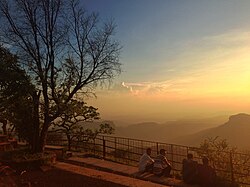
[[File:Sunset Point.JPG|thumb|Sunset Point at Pachmarhi]] | [[File:Sunset Point.JPG|thumb|Sunset Point at Pachmarhi]] | ||
[[File:Catholic Church at Pachmarhi.JPG|thumb|Anglican Church at Pachmarhi was built around 1875 by the British. | [[File:Catholic Church at Pachmarhi.JPG|thumb|Anglican Church at Pachmarhi was built around 1875 by the British.]] | ||
[[File:Bee Fall.jpg|thumb|Bee Fall]] | [[File:Bee Fall.jpg|thumb|Bee Fall]] | ||
[[File:Famous Sitting Spot at Pachmarhi Lake.JPG|thumb|Sitting spot at Pachmarhi Lake]] | [[File:Famous Sitting Spot at Pachmarhi Lake.JPG|thumb|Sitting spot at Pachmarhi Lake]] | ||
Pachmarhi is a tourist retreat. | Pachmarhi is a tourist retreat. Tourists visit Pachmarhi throughout the year. There are numerous hotels, most of which are located near the market. Only a few cottages, resorts, and MP tourism hotels are located in the Pachmarhi area, about 2 to 3 kilometres from the bus stop.<ref>{{Cite web|title=How to Reach {{!}} Pachmari Tour|url=https://www.pachmarhi.com/how-to-reach/|access-date=2022-02-18|language=en-US}}</ref> | ||
Pachmarhi's forests are home to numerous cave paintings, some of which are estimated to be 10,000 years old.<ref>{{Cite web |date=2012-09-12 |title=International attention for Pachmarhi rock art |url=https://www.hindustantimes.com/india/international-attention-for-pachmarhi-rock-art/story-uweerO59ZyEdUSFIFacUDI.html |access-date=2022-04-04 |website=Hindustan Times |language=en}}</ref> The garden at the base of Pandava Caves, a tourist attraction, is depicted in the photograph. Although the caves are Buddhist in nature, the name has stuck. The area has abundant timber reserves, including teak, but due to its status as a reserve, no new construction or tree felling is permitted. Pachmarhi, which has a diverse and rare flora and fauna, requires central and state government approval for any new construction outside of the town limits. | Pachmarhi's forests are home to numerous cave paintings, some of which are estimated to be 10,000 years old.<ref>{{Cite web |date=2012-09-12 |title=International attention for Pachmarhi rock art |url=https://www.hindustantimes.com/india/international-attention-for-pachmarhi-rock-art/story-uweerO59ZyEdUSFIFacUDI.html |access-date=2022-04-04 |website=Hindustan Times |language=en}}</ref> The garden at the base of Pandava Caves, a tourist attraction, is depicted in the photograph. Although the caves are Buddhist in nature, the name has stuck. The area has abundant timber reserves, including teak, but due to its status as a reserve, no new construction or tree felling is permitted. Pachmarhi, which has a diverse and rare flora and fauna, requires central and state government approval for any new construction outside of the town limits. | ||
Some of the places of tourist interest | Some of the places of tourist interest there are: | ||
*[[Rajat Prapat]] (large waterfall) | *[[Rajat Prapat]] (large waterfall) | ||
| Line 201: | Line 202: | ||
===Wildlife=== | ===Wildlife=== | ||
In the Satpura Tiger Reserve, large mammal species include [[tiger]], [[leopard]], [[wild boar]], [[gaur|gaur (''Bos gaurus'')]], [[chital deer|chital deer (''Axis axis'')]], [[muntjac deer]], [[sambar deer|sambar deer (''Cervus unicolor'')]], and [[rhesus macaque]]s. | |||
The endemic fauna includes [[chinkara]], [[nilgai]], wild dogs, the [[Indian wolf]], bison, [[Indian giant squirrel]]s, and flying squirrels. | The endemic fauna includes [[chinkara]], [[nilgai]], wild dogs, the [[Indian wolf]], bison, [[Indian giant squirrel]]s, and flying squirrels. | ||
===Biosphere=== | ===Biosphere=== | ||
The forests of Pachmarhi, especially in the summer, are densely forested with fruit trees such as mangoes, jamun, custard fruit, and lesser-known | The forests of Pachmarhi, especially in the summer, are densely forested with fruit trees such as mangoes, jamun, custard fruit, and lesser-known local fruits such as khatua, tendu, chunna, khinni, and chaar. Oak and blue pine are also abundant. The forest is also known for its abundance of medicinal plants and herbs. | ||
===Dhupgarh=== | ===Dhupgarh=== | ||
Satpura | The Satpura Range's highest point is 1,352 m. It's well-known for its sunrise and sunset views. At night, one can see the lights of neighbouring towns such as [[Itarsi]]. The summit can be reached by road or by foot. | ||
===Chauragarh=== | ===Chauragarh=== | ||
[[File:Chouragarh_temple.jpg|thumb|Trishuls at Chauragarh]] | [[File:Chouragarh_temple.jpg|thumb|Trishuls at Chauragarh]] | ||
This is the third highest peak. It is a pilgrimage site with Lord Siva's temple at the top. | This is the third highest peak in the Satpura ranges. It is a pilgrimage site with Lord Siva's temple at the top. The Chauragarh fort there was built by king [[Sangram Shah]] of the [[Gondi people#History of Gondwana and Rani Durgawati|Gond dynasty]]. It was developed by SenaSahebSubha Janoji Maharaj of Nagpur। from the Maratha Era the Pilgrimage from Nagpur Start।. It is also a widely known spot for sunrise viewing. During the festivities of Nagpanchami and Mahashivratri, devotees flock to Chauragarh temple in large numbers, leaving about 2 lakh ''[[trishula|trishuls]]'' as offerings which are kept in front of the temple and also in the way of the temple. | ||
===Bee Hill and Bee Falls=== | ===Bee Hill and Bee Falls=== | ||
This is a waterfall in Pachmarhi. It is named | This is a waterfall in Pachmarhi. It is so named because from a distance the waterfall sounds like a bee. Bee Falls takes its name from bees since this place is famous for honeybees. | ||
=== Dutchess Fall === | === Dutchess Fall === | ||
This waterfall is the most remote.{{citation needed|date=August | This waterfall is the most remote.{{citation needed|date=August 2020}} There are [[Doctor Fish]] in the pool made by the waterfall. The road to this waterfall is extreme, with very steep inclinations. There is straight downward trekking of 1 km. | ||
===PanarPani=== | ===PanarPani=== | ||
Panarpani has a natural | Panarpani has a natural freshwater lake with forest around it. | ||
===Sangam=== | ===Sangam=== | ||
| Line 228: | Line 229: | ||
===Jatashankar and Mahadev caves=== | ===Jatashankar and Mahadev caves=== | ||
These are mountain caves with fresh water dripping from them. | These are mountain caves with fresh water dripping from them. Mountains feed the streams with fresh water, that they soak in during autumn. As the name suggests, these caves and many others are the abode of [[lord Siva]]. | ||
===Silver Falls=== | ===Silver Falls=== | ||
Also called Rajat Prapat/Big Fall. The falls | Also called Rajat Prapat/Big Fall. The falls drop over 2800 feet through the gorge, leaving a silver streak behind that gives its name {{Cn|date=February 2023}}. | ||
===Apsara Vihar=== | ===Apsara Vihar=== | ||
[[File:Water fall Apsara Vihar (Fairy Pool).jpg|thumb|Water fall Apsara Vihar (Fairy Pool)]] | [[File:Water fall Apsara Vihar (Fairy Pool).jpg|thumb|Water fall Apsara Vihar (Fairy Pool)]] | ||
This is a mountain stream that creates a natural water pool, cascades and waterfall in its course.{{citation needed|date=August | This is a mountain stream that creates a natural water pool, cascades and waterfall in its course.{{citation needed|date=August 2020}} | ||
===Other waterfalls=== | ===Other waterfalls=== | ||
{{unreferenced section|date=December | {{unreferenced section|date=December 2018}} | ||
Pachmarhi's ecosystem includes other waterfalls such as Little Fall. | Pachmarhi's ecosystem includes other waterfalls such as Little Fall. | ||
| Line 251: | Line 252: | ||
*[[Aśoka (film)|Aśoka]] (film 2001), featuring [[Shah Rukh Khan]], [[Kareena Kapoor Khan]] | *[[Aśoka (film)|Aśoka]] (film 2001), featuring [[Shah Rukh Khan]], [[Kareena Kapoor Khan]] | ||
*[[Chakravyuh (2012 film)|Chakravyuh]](film 2012), featuring [[Arjun Rampal]], [[Abhay Deol]], [[Manoj Bajpai]], [[Om Puri]], [[Esha Gupta]] | *[[Chakravyuh (2012 film)|Chakravyuh]](film 2012), featuring [[Arjun Rampal]], [[Abhay Deol]], [[Manoj Bajpai]], [[Om Puri]], [[Esha Gupta]] | ||
*[[Trinetra ]](1991 film), featuring [[Mithun Chakraborty ]], [[Amrish Puri]] | |||
==Access== | ==Access== | ||
Pachmarhi is well connected from [[ | Pachmarhi is well connected from [[Narmadapuram]], [[Bhopal]], [[Itarsi]], [[Chhindwara]], [[Gadarwara]], [[Narsinghpur]], [[Indore]], [[Jabalpur]]. Buses start from [[Habibganj|Rani Kamalapati]] ISBT of Bhopal and generally take close to 5–6 hours. From Indore it takes 10–11 hours via Bhopal to reach Pachmarhi. The buses move through different towns like [[Narmadapuram district|Narmadapuram]], [[Chhindwara]], [[Madhya Pradesh|Makhan Nagar]], [[Sohagpur]] and [[Pipariya, Hoshangabad|Pipariya]]. The road's name is State Highway 19, and its name changes to State Highway 19A from the village of Matkuli to Pachmarhi. Matkuli is trijunction of Pipariya-Chhindwara-Pachmarhi way, and Pachmarhi is nearest from here, about 28 km. Pipariya is the nearest railhead, many trains on Mumbai-Kolkata route stop at Pipariya.. [[Itarsi Junction]] is also a major railhead near Pachmari. [[Madhya Pradesh Tourism Development Corporation]] buses are available for Pachmarhi from [[Indore]], [[Bhopal]]. These buses are air-conditioned. | ||
[[Itarsi Junction]] is also a major railhead near | |||
[[Madhya Pradesh Tourism Development Corporation]] buses are available for Pachmarhi from [[Indore]], [[Bhopal]]. These buses are air-conditioned. | |||
==Transport== | ==Transport== | ||
| Line 265: | Line 265: | ||
==External links== | ==External links== | ||
* [http://www.pachmarhitours.com Pachmarhi Travel Company] | * [http://www.pachmarhitours.com Pachmarhi Travel Company] | ||
* {{Cite EB1911|wstitle=Pachmarhi|short=x}} | * {{Cite EB1911|wstitle=Pachmarhi|short=x}} | ||
* [https://web.archive.org/web/20100324223519/http://www.pachmarhi-hill-station.com/pachmarhi.html About Pachmarhi and its History] | * [https://web.archive.org/web/20100324223519/http://www.pachmarhi-hill-station.com/pachmarhi.html About Pachmarhi and its History] | ||
{{Narmadapuram Division}} | {{Narmadapuram Division}} | ||
| Line 282: | Line 280: | ||
[[Category:Cantonments of British India]] | [[Category:Cantonments of British India]] | ||
[[Category:Tourism in Madhya Pradesh]] | [[Category:Tourism in Madhya Pradesh]] | ||
Latest revision as of 07:11, 22 July 2023
 |
Pachmarhi | |
|---|---|
Hill station | |
 Handi khoh Pachmarhi | |
| Nickname: Queen of Satpura | |
  Pachmarhi  Pachmarhi | |
| Coordinates: 22°28′00″N 78°24′40″E / 22.4667°N 78.4110°E | |
| Country | India |
| State | Madhya Pradesh |
| District | Narmadapuram |
| Elevation | 1,067 m (3,501 ft) |
| Languages | |
| • Official | Hindi |
| Time zone | UTC+5:30 (IST) |
| PIN | 461881 |
| Telephone code | +91 7578 |
| Vehicle registration | MP-05 |
| Nearest city | Pipariya |
Pachmarhi is a hill station in the Narmadapuram district of Madhya Pradesh state of central India. It has been the location of a cantonment (Pachmarhi Cantonment) since British Raj.[2]
It is widely known as Satpura ki Rani ("Queen of Satpura"), situated at the height of 1067 m in a valley of the Satpura Range in the Narmadapuram district. Dhupgarh, the highest point (1,352 m) in Madhya Pradesh and the Satpura range, is located here. It is a part of the Satpura Biosphere Reserve. It is also famous for the Satpura Tiger Reserve, Satpura National Park, Lord Shiva and the Pandavas of Mahabharata.
History[edit | edit source]
The name Pachmarhi is believed to be derived from the Hindi words Panch ("five") and Marhi ("caves"). According to a legend, these caves were built by five Pandava brothers of Mahabharatha era during their thirteen years of exile.[citation needed] The caves are situated on a hilltop and provide an excellent vantage point.
Pachmadhi region was Ruled by Bhonsale Kings।. It came under Marathas in the 18th century under SenaSahebSubha Maharaj Raghuji Raje Bhonsale।.
Before the British, the Pachmarhi region was under the kingdom of the Gond Bhagvat Singh, although it was not a populated village or town at that time. Captain James Forsyth of the British Army along with Subhedar Major Nathoo Ramji Powar, who was later made the Kotwal (in charge of the armoury) of Pachmarhi, spotted the plateau in the Pachmarhi region in 1857 while leading his troops on the way to Jhansi.[3] It quickly developed into hill station and sanatorium for British troops in the Central Provinces of India.
The population in 1901 was 3,020, rising to double that number in the hot summer months. Pachmarhi also served as the summer capital for the Central Provinces.
The forest around the town is home to many rare varieties of plants. UNESCO added Pachmarhi park to its list of Biosphere Reserves in May 2009.
The total area of Pachmarhi Biosphere Reserve is 4981.72 km2. It is located at longitude 22° 11’ to 22° 50’N and latitude 77° 47’ to 78° 52’E. It covers parts of three civil districts, viz; Narmadapuram (59.55%), Chhindwara (29.19%) and Betul (11.26%). It includes three wildlife conservation units viz., Bori Sanctuary 485.72 km2), Satpura National Park (524.37 km2) and Pachmarhi Sanctuary (491.63 km2).[4][5]
Town[edit | edit source]
The town is small and most of its area is under the administration of the Pachmarhi Cantonment Board, serving the Indian Army. It is the center of the Army Education Corps (AEC). The population of Pachmarhi is about 12,062 as per the report released by Census India 2011, most of whom are connected with the Army installations, tourism, and forest department.
An airstrip is situated on the way to Dhupgarh. It is overrun with grass and is seldom used. Tigers and bison are known to have been sighted nearby. A helipad is also present near the airstrip. Leopard sightings are also common along the edge of the Pachmarhi Cantonment.
Climate[edit | edit source]
The climate is mild, with temperatures ranging from warm to cool. Summers have significantly more rainfall than winters. Köppen and Geiger classify this location as Cwa. The average temperature in this area is 21.7 °C. The average rainfall in this area is 2012 mm. May is the hottest month of the year, with an average temperature of 30.3 °C. December is the coldest month of the year, with an average temperature of 15.5 °C.[6]
| Climate data for Pachmarhi | |||||||||||||
|---|---|---|---|---|---|---|---|---|---|---|---|---|---|
| Month | Jan | Feb | Mar | Apr | May | Jun | Jul | Aug | Sep | Oct | Nov | Dec | Year |
| Record high °C (°F) | 30.6 (87.1) |
33 (91) |
36.1 (97.0) |
40 (104) |
40.6 (105.1) |
40.6 (105.1) |
37.4 (99.3) |
31 (88) |
35.6 (96.1) |
31.9 (89.4) |
29.5 (85.1) |
27.8 (82.0) |
40.6 (105.1) |
| Average high °C (°F) | 22.7 (72.9) |
25 (77) |
29.2 (84.6) |
33.7 (92.7) |
36.3 (97.3) |
31.7 (89.1) |
24.6 (76.3) |
24.1 (75.4) |
25.6 (78.1) |
26.5 (79.7) |
24.5 (76.1) |
23.2 (73.8) |
27.3 (81.1) |
| Average low °C (°F) | 8.9 (48.0) |
10.6 (51.1) |
15 (59) |
20.1 (68.2) |
24.3 (75.7) |
22.6 (72.7) |
19.9 (67.8) |
19.7 (67.5) |
19.2 (66.6) |
15 (59) |
9.9 (49.8) |
7.8 (46.0) |
16.1 (61.0) |
| Record low °C (°F) | −2.8 (27.0) |
−0.6 (30.9) |
3.3 (37.9) |
8.9 (48.0) |
13 (55) |
15.2 (59.4) |
12.2 (54.0) |
13.4 (56.1) |
12.4 (54.3) |
6.7 (44.1) |
1.3 (34.3) |
−1.4 (29.5) |
−2.8 (27.0) |
| Average precipitation mm (inches) | 23 (0.9) |
16 (0.6) |
17 (0.7) |
9 (0.4) |
12 (0.5) |
173 (6.8) |
640 (25.2) |
616 (24.3) |
423 (16.7) |
62 (2.4) |
13 (0.5) |
8 (0.3) |
2,012 (79.3) |
| Source: Climate data[6][7] | |||||||||||||
Tourism[edit | edit source]
 | This section does not cite any sources. (May 2017) |


Pachmarhi is a tourist retreat. Tourists visit Pachmarhi throughout the year. There are numerous hotels, most of which are located near the market. Only a few cottages, resorts, and MP tourism hotels are located in the Pachmarhi area, about 2 to 3 kilometres from the bus stop.[8]
Pachmarhi's forests are home to numerous cave paintings, some of which are estimated to be 10,000 years old.[9] The garden at the base of Pandava Caves, a tourist attraction, is depicted in the photograph. Although the caves are Buddhist in nature, the name has stuck. The area has abundant timber reserves, including teak, but due to its status as a reserve, no new construction or tree felling is permitted. Pachmarhi, which has a diverse and rare flora and fauna, requires central and state government approval for any new construction outside of the town limits.
Some of the places of tourist interest there are:
- Rajat Prapat (large waterfall)
- Bee Fall
- Bada Mahadev
- Gupt Mahadev
- Chauragarh (Shiv devotees come here in huge numbers during Mahashivratri)
- Dhupgarh (the highest peak of the Satpuras and Madhya Pradesh)
- Handi Khoh (deep valley)
- Apsara Falls (fairy pool)
- Jatashankar (stalagmite-filled cave in a deep ravine)
- Dutchess Fall
- Pachmarhi Hill (whole view of Pachmarhi City)
- Pansy Pool
- Waters Meet
- Picadilly Circus
- Patharchatta
- Crumps Crag
- Lady Robertson's View
- Colletin Crag
- Mount Rosa
- Reechgarh
- Rajendra Giri (gardens with natural scenery)
- Bansri Vihar
- Little Fall
- Naagdwari
- Draupadi Kund
- Twynham Pool
- Chhota Mahadev
- Nandigad
Pachmarhi offers a variety of natural attractions such as lake boating, paragliding, greenery, views, waterfalls, mountain streams, and wildlife. Pachmarhi is also home to the National Adventure Institute, which hosts a variety of adventure training camps. Bharat Scout & Guides is also located there.
Wildlife[edit | edit source]
In the Satpura Tiger Reserve, large mammal species include tiger, leopard, wild boar, gaur (Bos gaurus), chital deer (Axis axis), muntjac deer, sambar deer (Cervus unicolor), and rhesus macaques.
The endemic fauna includes chinkara, nilgai, wild dogs, the Indian wolf, bison, Indian giant squirrels, and flying squirrels.
Biosphere[edit | edit source]
The forests of Pachmarhi, especially in the summer, are densely forested with fruit trees such as mangoes, jamun, custard fruit, and lesser-known local fruits such as khatua, tendu, chunna, khinni, and chaar. Oak and blue pine are also abundant. The forest is also known for its abundance of medicinal plants and herbs.
Dhupgarh[edit | edit source]
The Satpura Range's highest point is 1,352 m. It's well-known for its sunrise and sunset views. At night, one can see the lights of neighbouring towns such as Itarsi. The summit can be reached by road or by foot.
Chauragarh[edit | edit source]

This is the third highest peak in the Satpura ranges. It is a pilgrimage site with Lord Siva's temple at the top. The Chauragarh fort there was built by king Sangram Shah of the Gond dynasty. It was developed by SenaSahebSubha Janoji Maharaj of Nagpur। from the Maratha Era the Pilgrimage from Nagpur Start।. It is also a widely known spot for sunrise viewing. During the festivities of Nagpanchami and Mahashivratri, devotees flock to Chauragarh temple in large numbers, leaving about 2 lakh trishuls as offerings which are kept in front of the temple and also in the way of the temple.
Bee Hill and Bee Falls[edit | edit source]
This is a waterfall in Pachmarhi. It is so named because from a distance the waterfall sounds like a bee. Bee Falls takes its name from bees since this place is famous for honeybees.
Dutchess Fall[edit | edit source]
This waterfall is the most remote.[citation needed] There are Doctor Fish in the pool made by the waterfall. The road to this waterfall is extreme, with very steep inclinations. There is straight downward trekking of 1 km.
PanarPani[edit | edit source]
Panarpani has a natural freshwater lake with forest around it.
Sangam[edit | edit source]
This is a conflux of mountain streams behind Dhupgarh. The water in these streams is crystal clear in all seasons except of course autumn.
Jatashankar and Mahadev caves[edit | edit source]
These are mountain caves with fresh water dripping from them. Mountains feed the streams with fresh water, that they soak in during autumn. As the name suggests, these caves and many others are the abode of lord Siva.
Silver Falls[edit | edit source]
Also called Rajat Prapat/Big Fall. The falls drop over 2800 feet through the gorge, leaving a silver streak behind that gives its name [citation needed].
Apsara Vihar[edit | edit source]
.jpg)
This is a mountain stream that creates a natural water pool, cascades and waterfall in its course.[citation needed]
Other waterfalls[edit | edit source]
| This section does not cite any sources. (December 2018) |
Pachmarhi's ecosystem includes other waterfalls such as Little Fall.
New year event in Pachmarhi utsav
Every year from 25 to 31 December, Pachmarhi utsav is organized by govt. Of Mp. In which various celebrities have been called to perform stage shows at utsav ground and various places. At the end of 31 an event is organized by local association Pachmarhi Partyan Mitra and MARRS
Film location[edit | edit source]
- Massey Sahib (film 1985), featuring Raghuvir Yadav, Barry John, Arundhati Roy
- Thodasa Roomani Ho Jaayen (film 1990), featuring Nana Patekar, Anita Kanwar
- Tarkieb (film 2000), featuring Nana Patekar, Tabbu, Raghuveer Yadav, Shilpa Shetty, Milind Soman
- Aśoka (film 2001), featuring Shah Rukh Khan, Kareena Kapoor Khan
- Chakravyuh(film 2012), featuring Arjun Rampal, Abhay Deol, Manoj Bajpai, Om Puri, Esha Gupta
- Trinetra (1991 film), featuring Mithun Chakraborty , Amrish Puri
Access[edit | edit source]
Pachmarhi is well connected from Narmadapuram, Bhopal, Itarsi, Chhindwara, Gadarwara, Narsinghpur, Indore, Jabalpur. Buses start from Rani Kamalapati ISBT of Bhopal and generally take close to 5–6 hours. From Indore it takes 10–11 hours via Bhopal to reach Pachmarhi. The buses move through different towns like Narmadapuram, Chhindwara, Makhan Nagar, Sohagpur and Pipariya. The road's name is State Highway 19, and its name changes to State Highway 19A from the village of Matkuli to Pachmarhi. Matkuli is trijunction of Pipariya-Chhindwara-Pachmarhi way, and Pachmarhi is nearest from here, about 28 km. Pipariya is the nearest railhead, many trains on Mumbai-Kolkata route stop at Pipariya.. Itarsi Junction is also a major railhead near Pachmari. Madhya Pradesh Tourism Development Corporation buses are available for Pachmarhi from Indore, Bhopal. These buses are air-conditioned.
Transport[edit | edit source]
The nearest airport is Bhopal. The nearest railway station is Pipariya.
References[edit | edit source]
- ↑ "Pachmarhi – the Saucer Shaped Valley | TravelDest". 20 July 2010. Archived from the original on 17 June 2012. Retrieved 21 June 2012.
- ↑ "Pachmarhi, Jewel in the crown of Central India". Times of India. Archived from the original on 13 December 2013. Retrieved 25 December 2021.
- ↑ Pachmarhi Travel Guide. Goodearth Publications. 2009. p. 6. ISBN 978-81-87780-95-3. Archived from the original on 14 February 2017. Retrieved 5 October 2016.
- ↑ "Three Indian sites added to UNESCO list of biosphere reserves". Sify. 27 May 2009. Archived from the original on 28 October 2014. Retrieved 30 May 2009.
- ↑ "UNESCO Designates 22 New Biosphere Reserves". Environment News Service. 27 May 2009. Archived from the original on 3 March 2016. Retrieved 30 May 2009.
- ↑ 6.0 6.1 "Pachmarhi climate: Average Temperature, weather by month, Pachmarhi weather averages - Climate-Data.org". en.climate-data.org. Archived from the original on 22 June 2019. Retrieved 25 December 2021.
- ↑ "Archived copy" (PDF). Archived from the original (PDF) on 16 March 2014. Retrieved 25 January 2014.
{{cite web}}: CS1 maint: archived copy as title (link) - ↑ "How to Reach | Pachmari Tour". Retrieved 18 February 2022.
- ↑ "International attention for Pachmarhi rock art". Hindustan Times. 12 September 2012. Retrieved 4 April 2022.
External links[edit | edit source]
- Pachmarhi Travel Company
- . Encyclopædia Britannica (11th ed.). 1911.
- About Pachmarhi and its History