.svg)
Reckong Peo: Difference between revisions
imported>Mukilteoedits m (typo) |
WikiDwarfBOT (talk | contribs) (Cleanup:) |
||
| Line 20: | Line 20: | ||
| subdivision_name = {{flag|India}} | | subdivision_name = {{flag|India}} | ||
| subdivision_type1 = [[States and territories of India|State]] | | subdivision_type1 = [[States and territories of India|State]] | ||
| subdivision_name1 = {{flagicon image| | | subdivision_name1 = {{flagicon image|}} [[Himachal Pradesh]] | ||
| subdivision_type2 = [[List of districts of India|District]] | | subdivision_type2 = [[List of districts of India|District]] | ||
| subdivision_name2 = [[Kinnaur district|Kinnaur]] | | subdivision_name2 = [[Kinnaur district|Kinnaur]] | ||
| Line 61: | Line 61: | ||
'''Reckong Peo''', also spelled '''Rekong Peo''' or simply known as '''Peo''' by the local inhabitants, is headquarters of [[Kinnaur district]], one of the twelve administrative districts of the [[India]]n state of [[Himachal Pradesh]]. | '''Reckong Peo''', also spelled '''Rekong Peo''' or simply known as '''Peo''' by the local inhabitants, is headquarters of [[Kinnaur district]], one of the twelve administrative districts of the [[India]]n state of [[Himachal Pradesh]]. | ||
At a height of 2,290 metres (7,513 ft), Reckong Peo is 260 | At a height of 2,290 metres (7,513 ft), Reckong Peo is 260 kilometers (162 miles) from [[Shimla]] and seven kilometers (4⅓ miles) from Powari ― a place on NH5. Earlier [[Kalpa, Himachal Pradesh|Kalpa]] was the headquarter of the Kinnaur district administration. It was later shifted down to Reckong Peo. The place is named after a group of people who used to own this place in ancient times.<ref>{{Cite web|last=|first=|date=|title=Kinnaur (Government of Himachal Pradesh)|url=https://hpkinnaur.nic.in/tourist-place/kalpa/|access-date=|website=Kinnaur}}</ref> | ||
Reckong Peo serves as a base for the pilgrims who go for an annual three days trek to | Reckong Peo serves as a base for the pilgrims who go for an annual three days trek to an 80 feet high holy rock pillar that is considered to be as [[Shiva|Lord Shiv]] or ‘[[Lingam|Shivalinga]]’. Whereas a clockwise ‘[[Parikrama]]’ (circumambulation) trek around the holy rock start from Charang village and end at Chitkul after traversing a long and challenging terrain.<ref>{{Cite web|last=|first=|date=|title=Recong Peo Himachal Tourism|url=http://himachaltourism.gov.in/destination/kinnaur/|access-date=|website=Himachal Tourism Official Site}}</ref> | ||
<ref>{{Cite web|last=|first=|date=|title=Kinnaur Kailash Parikrama trek|url=https://raachotrekkers.com/kinner-kailash-parikrama-charang-la-trek/|access-date=|website=Raacho Trekkers}}</ref> | <ref>{{Cite web|last=|first=|date=|title=Kinnaur Kailash Parikrama trek|url=https://raachotrekkers.com/kinner-kailash-parikrama-charang-la-trek/|access-date=|website=Raacho Trekkers}}</ref> | ||
{{clear|left}} | {{clear|left}} | ||
Reckong Peo is also the commercial and administrative | Reckong Peo is also the commercial and administrative center of the Kinnaur district as the biggest market of the entire district is located here and all important governmental as well as administrative offices are located at Reckong Peo. Tourists can take buses to visit all the important villages and other places of the district from the HRTC Bus Stand at Reckong Peo. | ||
==Places Of Interest== | ==Places Of Interest== | ||
| Line 78: | Line 78: | ||
The primary attractions of Recong Peo are the [[Chandi]] Mata Temple and [[Bhaba valley|Bhabha Valley]]. Apart from [[Kinnaur Kailash]] high mountain peak, you can also observe the high mountain peak of Raldang located in [[Great Himalayas|Greater Himalayas]].<ref>{{Cite web|last=|first=|date=|title=Recong Peo "Abode of Gods"|url=https://www.wildtriumph.com/reckong-peo|access-date=|website=Wild Triumph}}</ref> | The primary attractions of Recong Peo are the [[Chandi]] Mata Temple and [[Bhaba valley|Bhabha Valley]]. Apart from [[Kinnaur Kailash]] high mountain peak, you can also observe the high mountain peak of Raldang located in [[Great Himalayas|Greater Himalayas]].<ref>{{Cite web|last=|first=|date=|title=Recong Peo "Abode of Gods"|url=https://www.wildtriumph.com/reckong-peo|access-date=|website=Wild Triumph}}</ref> | ||
Apple orchards are found in abundance due to | Apple orchards are found in abundance due to favorable climatic conditions. Houses are built traditionally that depict the culture and lifestyle of Himachal Pradesh. | ||
The nearest airport is Kullu Manali Airport, 245 km from Reckong Peo by road. | |||
==Gallery== | ==Gallery== | ||
| Line 100: | Line 100: | ||
* [https://web.archive.org/web/20080915082632/http://hpkinnaur.nic.in/touristspots.htm#reckong Info on Reckong Peo from Government of India portal] | * [https://web.archive.org/web/20080915082632/http://hpkinnaur.nic.in/touristspots.htm#reckong Info on Reckong Peo from Government of India portal] | ||
[[Category:Cities and towns in Kinnaur district]] | [[Category:Cities and towns in Kinnaur district]] | ||
Latest revision as of 07:21, 22 July 2023
This article needs additional citations for verification. (August 2018) |
Reckong Peo
Peo | |
|---|---|
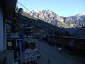
 Main street, Reckong Peo, 2010 | |
 Reckong Peo Location in Himachal Pradesh, India  Reckong Peo Reckong Peo (India) | |
| Coordinates: 31°32′25″N 78°16′20″E / 31.540278°N 78.272222°ECoordinates: 31°32′25″N 78°16′20″E / 31.540278°N 78.272222°E | |
| Country | |
| State | |
| District | Kinnaur |
| Elevation | 2,290 m (7,510 ft) |
| Population | |
| • Total | 2,397 (1,529 males 868 females) |
| Languages | |
| • Official | Hindi |
| Time zone | UTC+5:30 (IST) |
| Nearest towns | Bhaba Nagar, Rampur, Kumarsain, Pooh, Kaza. |
| Lok Sabha constituency | Mandi |
| Vidhan Sabha constituency | Kinnaur |

Reckong Peo, also spelled Rekong Peo or simply known as Peo by the local inhabitants, is headquarters of Kinnaur district, one of the twelve administrative districts of the Indian state of Himachal Pradesh.
At a height of 2,290 metres (7,513 ft), Reckong Peo is 260 kilometers (162 miles) from Shimla and seven kilometers (4⅓ miles) from Powari ― a place on NH5. Earlier Kalpa was the headquarter of the Kinnaur district administration. It was later shifted down to Reckong Peo. The place is named after a group of people who used to own this place in ancient times.[1]
Reckong Peo serves as a base for the pilgrims who go for an annual three days trek to an 80 feet high holy rock pillar that is considered to be as Lord Shiv or ‘Shivalinga’. Whereas a clockwise ‘Parikrama’ (circumambulation) trek around the holy rock start from Charang village and end at Chitkul after traversing a long and challenging terrain.[2] [3]
Reckong Peo is also the commercial and administrative center of the Kinnaur district as the biggest market of the entire district is located here and all important governmental as well as administrative offices are located at Reckong Peo. Tourists can take buses to visit all the important villages and other places of the district from the HRTC Bus Stand at Reckong Peo.
Places Of Interest[edit]
- Bodh Mandir (Buddhist Temple)
- Durga Mata Temple, Kothi.
- Telangi view point.
- Dakho view point.
- Khawangi Temple.
The primary attractions of Recong Peo are the Chandi Mata Temple and Bhabha Valley. Apart from Kinnaur Kailash high mountain peak, you can also observe the high mountain peak of Raldang located in Greater Himalayas.[4]
Apple orchards are found in abundance due to favorable climatic conditions. Houses are built traditionally that depict the culture and lifestyle of Himachal Pradesh.
The nearest airport is Kullu Manali Airport, 245 km from Reckong Peo by road.
Gallery[edit]


Entrance of Recong Peo Hospital in Himachal Pradesh 2015


References[edit]
- ↑ "Kinnaur (Government of Himachal Pradesh)". Kinnaur.
- ↑ "Recong Peo Himachal Tourism". Himachal Tourism Official Site.
- ↑ "Kinnaur Kailash Parikrama trek". Raacho Trekkers.
- ↑ "Recong Peo "Abode of Gods"". Wild Triumph.
External links[edit]
- Fresh spell of snowfall and light showers in the upper reaches of the hill state
- Info on Reckong Peo from Government of India portal
This Himachal Pradesh location article is a stub. You can help Wikipedia by expanding it. |