Perinthalmanna taluk
 Thank you for being part of the Bharatpedia family! 0% transparency: ₹0 raised out of ₹100,000 (0 supporter) |
Perinthalmanna Taluk, formerly known as Walluvanad Taluk, comes under Perinthalmanna revenue division in Malappuram district of Kerala, India.[1] Its headquarters is the town of Perinthalmanna.[1] Perinthalmanna Taluk contains Perinthalmanna Municipality and 15 Gram panchayats.[1] Most of the administrative offices are located in the Mini-Civil Station at Perinthalmanna.
Perinthalmanna Taluk | |
|---|---|
Taluk | |
.svg) Location in Malappuram district, Kerala, India | |
| Coordinates: 11°09′09″N 75°57′24″E / 11.152610°N 75.956678°ECoordinates: 11°09′09″N 75°57′24″E / 11.152610°N 75.956678°E | |
| Country | |
| State | Kerala |
| District | Malappuram |
| Headquarters | Perinthalmanna |
| Languages | |
| • Official | Malayalam, English |
| Time zone | UTC+5:30 (IST) |
| Vehicle registration | KL-53 |
GeographyEdit

Perinthalmanna Taluk is bounded by Kadalundi River (Eranad Taluk) to north, Thuthapuzha River (a tributary of Bharathappuzha) to south, Kuttippuram block of Tirur Taluk to west, and Mannarkkad Taluk (Silent Valley) to east.[2][3]
HistoryEdit
.svg)
Perinthalmanna was the headquarters of the Old Walluvanad Taluk in the British Malabar District.[4] Walluvanad Taluk was divided into six Revenue blocks: Mankada, Perinthalmanna, Mannarkkad, Ottapalam, Sreekrishnapuram, and Pattambi.[4][5] Walluvanad was one of the two Taluks included in the Malappuram Revenue Division (the other being Eranad Taluk) of British Malabar.[4] On 1 November 1957, the Walluvanad Taluk was divided into two: Perinthalmanna Taluk and Ottapalam Taluk.[5] The Revenue blocks of Mankada, Perinthalmanna, and Mannarkkad were included in the Perinthalmanna Taluk, while Ottapalam, Sreekrishnapuram, and Pattambi were transferred to the newly formed Ottapalam Taluk.[5] Later Attappadi Revenue block was separated from Mannarkkad Block.[2]
During the formation of Malappuram district on 16 June 1969, the Revenue blocks of Mannarkkad and Attappadi were separated from Perinthalmanna Taluk to form Mannarkkad Taluk.[2] Now, Perinthalmanna Taluk has 24 villages.[3]
Municipality and PanchayatsEdit
The taluk contains 1 municipality and 15 panchayats:[3]
- Perinthalmanna Municipality
- Alipparamba Panchayat
- Angadippuram Panchayat
- Edappatta Panchayat
- Elamkulam Panchayat
- Keezhattur Panchayat
- Kodur Panchayat
- Kootilangadi Panchayat
- Kuruva Panchayat
- Mankada Panchayat
- Melattur Panchayat
- Moorkkanad Panchayat
- Pulamanthole Panchayat
- Puzhakkattiri Panchayat
- Tazhekkode Panchayat
- Vettathur Panchayat
VillagesEdit
The taluk contains 24 villages:[1]
- Aliparamba
- Anamangad
- Angadippuram
- Arakkuparamba
- Edappatta
- Elamkulam
- Kariavattom
- Keezhattur
- Kodur
- Koottilangadi
- Kuruva
- Kuruvambalam
- Mankada
- Melattur
- Moorkkanad
- Nenmini
- Pathaikara
- Perinthalmanna Town
- Pulamantol
- Puzhakkattiri
- Tazhekkode
- Vadakkangara
- Valambur
- Vettathur
Taluks of MalappuramEdit
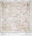
Historical mapsEdit

Malabar District in 1854
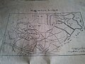
Valluvanad Taluk in 1909
An area of Valluvanad Taluk in 1912

Malabar District in 1951


.jpg)
See alsoEdit
ReferencesEdit
- ↑ 1.0 1.1 1.2 1.3 "Villages, Taluks, and Revenues divisions that make up Malappuram district". Official website of Malappuram district.
- ↑ 2.0 2.1 2.2 K. Narayanan (1972). District Census Handbook - Malappuram (Part-C) - 1971 (PDF). Thiruvananthapuram: Directorate of Census Operations, Kerala. p. 3.
- ↑ 3.0 3.1 3.2 Directorate of Census Operations, Kerala. District Census Handbook, Malappuram (PDF). Thiruvananthapuram: Directorate of Census Operations, Kerala.
- ↑ 4.0 4.1 4.2 1951 census handbook - Malabar district (PDF). Chennai: Government of Madras. 1953. p. 1.
- ↑ 5.0 5.1 5.2 Devassy, M. K. (1965). District Census Handbook (3) - Palakkad (1961) (PDF). Shoranur: Government of Kerala.