.svg)
Dakshin Maynadal
 Thank you for being part of the Bharatpedia family! 0% transparency: ₹0 raised out of ₹100,000 (0 supporter) |
Dakshin Maynadal | |
|---|---|
Village | |
 Dakshin Maynadal Location in West Bengal, India  Dakshin Maynadal Dakshin Maynadal (India) | |
| Coordinates: 22°26′46″N 87°44′00″E / 22.4462°N 87.7332°ECoordinates: 22°26′46″N 87°44′00″E / 22.4462°N 87.7332°E | |
| Country | |
| State | West Bengal |
| District | Purba Medinipur |
| Population (2011) | |
| • Total | 1,024 |
| Languages | |
| • Official | Bengali, English |
| Time zone | UTC+5:30 (IST) |
| PIN | 721139 |
| Telephone/STD code | 03228 |
| Lok Sabha constituency | Ghatal |
| Vidhan Sabha constituency | Panskura Paschim |
| Website | purbamedinipur |
Dakshin Maynadal is a village in the Panskura CD block in the Tamluk subdivision of the Purba Medinipur district in the state of West Bengal, India.
Geography[edit]
| Cities and towns in Tamluk subdivision of Purba Medinipur district M: municipal city/ town, CT: census town, R: rural/ urban centre, H: historical/ religious centre Owing to space constraints in the small map, the actual locations in a larger map may vary slightly |
Location[edit]
Dakshin Maynadal is located at 22°26′46″N 87°44′00″E / 22.4462°N 87.7332°E.
Urbanisation[edit]
94.08% of the population of Tamluk subdivision live in the rural areas. Only 5.92% of the population live in the urban areas, and that is the second lowest proportion of urban population amongst the four subdivisions in Purba Medinipur district, just above Egra subdivision.[1]
Note: The map alongside presents some of the notable locations in the subdivision. All places marked in the map are linked in the larger full screen map.
Demographics[edit]
According to the 2011 Census of India, Dakshin Maynadal had a total population of 1,024, of which 521 (51%) were males and 503 (49%) were females. There were 108 persons in the age range of 0–6 years. The total number of literate persons in Dakshin Maynadal was 712 (77.73% of the population over 6 years).[2]
Culture[edit]
The pancharatna Radha Gobinda temple is a 200-year-old structure that has been renovated, as per the renovation tablet in the temple. (see picture of tablet).
Dakshin Maynadal picture gallery[edit]

Radha Gobinda temple

Decoration
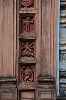
Decoration

Decoration

Renovation tablet


References[edit]
- ↑ "District Statistical Handbook 2014 Purba Medinipur". Table 2.2. Department of Planning and Statistics, Government of West Bengal. Archived from the original on 21 January 2019. Retrieved 20 April 2019.
- ↑ "CD block Wise Primary Census Abstract Data(PCA)". West Bengal – District-wise CD blocks. Registrar General and Census, India. Retrieved 16 August 2020.
External links[edit]
Cities, towns, locations and neighbourhoods in Purba Medinipur District | |||||||||
|---|---|---|---|---|---|---|---|---|---|
| Cities, municipal and census towns |
| ||||||||
| Locations other than cities and towns |
| ||||||||
| Neighbourhoods |
| ||||||||
| Related topics | |||||||||