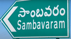
Sambavaram
Sambavaram is a village in the Kurnool district of the Indian state of Andhra Pradesh. It is located in Gospadu Mandal of Nandyal revenue division 2 km (1.2 mi) from NH 40.[1]
Sambavaram | |
|---|---|
| Coordinates: 15°24′45″N 78°29′37″E / 15.4125°N 78.4937°ECoordinates: 15°24′45″N 78°29′37″E / 15.4125°N 78.4937°E | |
| Country | India |
| State | Andhra Pradesh |
| District | Kurnool |
| Mandal | Gospadu |
| Population (2011) | |
| • Total | 2,813 |
| • Density | 400/km2 (1,000/sq mi) |
| Languages | |
| • Official | Telugu |
| Time zone | UTC+5:30 (IST) |
| PIN | 518502 Chabolu P.O |
EtymologyEdit
The word Samba సాంబశివుడు and Varam is వరంగా ఇచ్చాడు. The word ''Sambavaram'' has a close connection with ''Parvatipuram'' (a neighboring village).
GeographyEdit
Sambavaram is in east-Deebaguntla, west-Chabolu, south-Raitunagar, National Highway 40.
LandmarksEdit
A Saibaba temple and statue sit near National Highway 40.
DemographicsEdit
According to the 2011 census, Sambavaram has 2,813 people, including Hindus, Muslims, and Christians. Sambavaram has a total literacy rate of 53.9 percent and a female literacy rate of 21.7 percent.
AgricultureEdit
This village has paddies and many crops under the K. C. canal.[2]
EducationEdit
Sambavaram has a government-run primary school.
PoliticsEdit
Sambavaram is under the Nandyal Legislative Assembly.
TransportEdit
Roads and the Nandyal railway station are the available modes of transport.
ReferencesEdit
- ↑ "District Level Mandal wise List of Villages in Andhra Pradesh" (PDF). Chief Commissioner of Land Administration. National Informatics Centre. p. 12. Archived from the original (PDF) on 14 December 2014. Retrieved 15 December 2015.
- ↑ "Heritage Foods Ltd.". Company overview, Business Standard.

