.svg)
File:Yamama english.jpg

Size of this preview: 220 × 126 pixels. Other resolutions: 320 × 183 pixels | 500 × 286 pixels | 1,661 × 949 pixels.
Original file (1,661 × 949 pixels, file size: 819 KB, MIME type: image/jpeg)
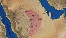
The historical province of Al-Yamamah at its greatest extent, as described by Yaqut and Al-Hamadani.
| This image is in the public domain because it is a screenshot from NASA’s globe software World Wind using a public domain layer, such as Blue Marble, MODIS, Landsat, SRTM, USGS or GLOBE.
|
 |
File history
Click on a date/time to view the file as it appeared at that time.
| Date/Time | Thumbnail | Dimensions | User | Comment | |
|---|---|---|---|---|---|
| current | 02:56, 16 June 2007 | | 1,661 × 949 (819 KB) | wikimediacommons>Slackerlawstudent~commonswiki | The historical province of Al-Yamamah at its greatest extent, as described by Yaqut and Al-Hamadani. {{PD-WorldWind}} Category:Maps of Saudi Arabia |
File usage
The following page uses this file: