.svg)
File:WorldMapCosmasIndicopleustes.jpg
Original file (1,539 × 1,208 pixels, file size: 654 KB, MIME type: image/jpeg)
Summary
| Description |
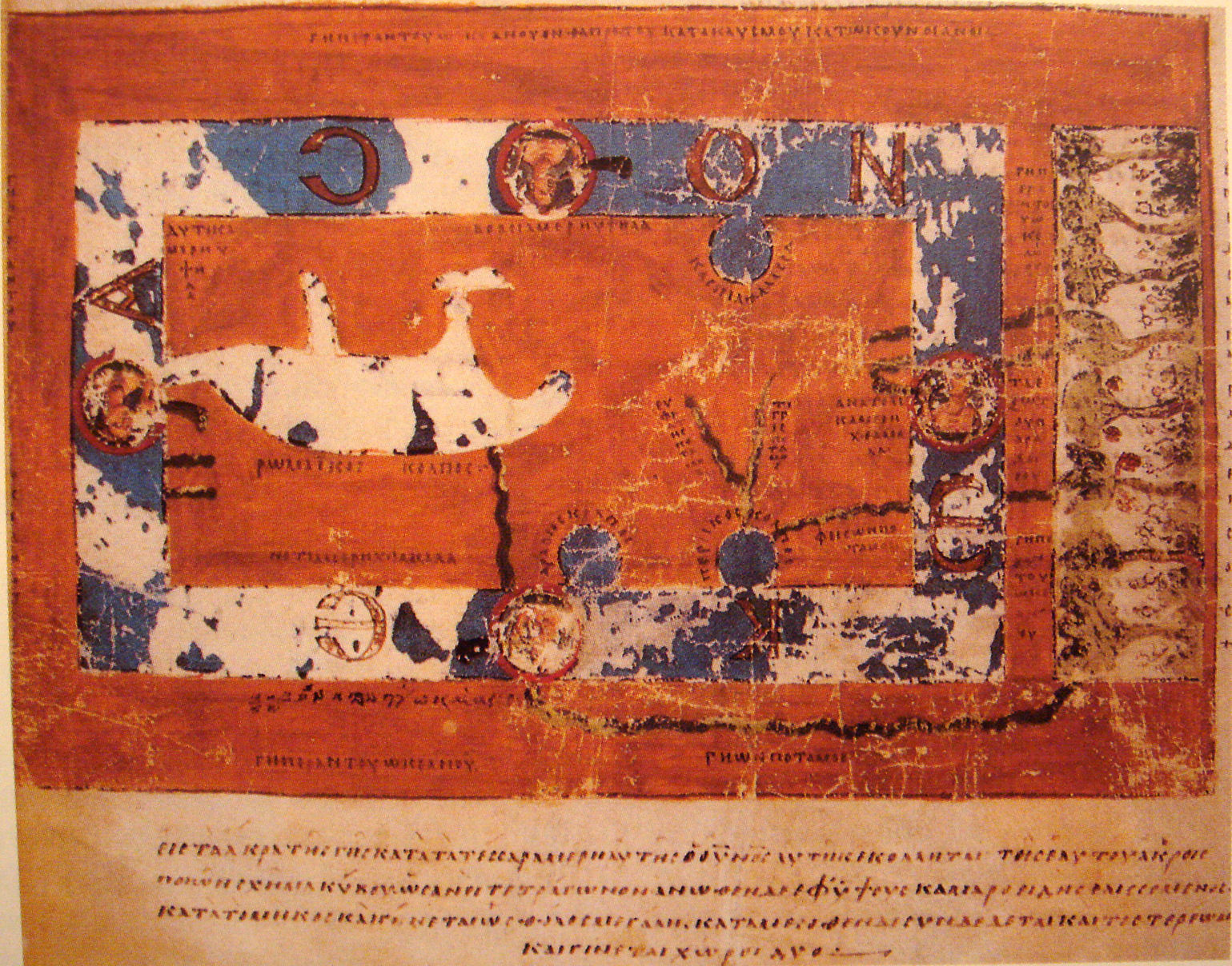
World Map by Cosmas Indicopleustes. The map is oriented with north to the top. It shows a rectangular landmass in the middle of the World Ocean ( ꙌΚΕΑΝΟϹ , Okeanos), reflecting what Cosmas thought was the "floor" of the tabernacle-shaped universe. The Roman Gulf (i.e., Mediterranean) is shown in the western half, with indentations for the unmarked Adriatic and Aegean/Black seas. Three further gulfs are shown: the Caspian to the northeast and the Arabian (i.e., Red Sea) and Persian gulfs to the south. Paradise is shown in the far east, beyond the Ocean. Four rivers run from it and cross under or through the Ocean to reach Asia and Africa. |
| Date | 6th century map. |
| Source | "Les Sciences au Moyen-Age", "Pour la Science" |
| Author | Cosmas Indicopleustes, 6th century |
| Other versions |
|

Licensing
|
This is a faithful photographic reproduction of a two-dimensional, public domain work of art. The work of art itself is in the public domain for the following reason:
The official position taken by the Wikimedia Foundation is that "faithful reproductions of two-dimensional public domain works of art are public domain". This photographic reproduction is therefore also considered to be in the public domain in the United States. In other jurisdictions, re-use of this content may be restricted; see Reuse of PD-Art photographs for details. {{PD-Art}} template without license parameter: please specify why the underlying work is public domain in both the source country and the United States
(Usage: {{PD-Art|1=|deathyear=''year of author's death''|country=''source country''}}, where parameter 1= can be PD-old-auto, PD-old-auto-expired, PD-old-auto-1996, PD-old-100 or similar. See Commons:Multi-license copyright tags for more information.) | ||||
| Annotations | This image is annotated: View the annotations at Commons |
File history
Click on a date/time to view the file as it appeared at that time.
| Date/Time | Thumbnail | Dimensions | User | Comment | |
|---|---|---|---|---|---|
| current | 00:03, 17 November 2007 | | 1,539 × 1,208 (654 KB) | wikimediacommons>World Imaging | {{Information |Description=World Map by Cosmas Indicopleustes |Source="Les Sciences au Moyen-Age", "Pour la Science" |Date=6th century map. |Author=Cosmas Indicopleustes, 6th century |Permission= |other_versions= }} |
File usage
The following page uses this file: