.svg)
File:VizagPort.jpg

Original file (583 × 388 pixels, file size: 33 KB, MIME type: image/jpeg)
Summary
| Description |
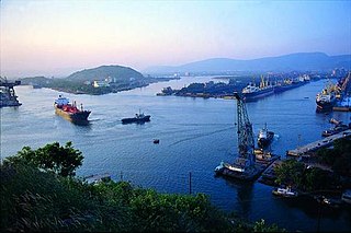
English: Port at Vizag విశాఖపటణ౦ ఓడరేవు Installation of 2 nos., harbour mobile cranes at West Quay berths of the inner harbour on hire basis. Visakhapatnam was an ancient Port city which had trade relations with the Middle East and Rome. Ships were anchored at open roads and were loaded with cargo transported from Visakhapatnam shore by means of small Masula boats. A reference to Vizagapatam merchant is available in the inscriptions of Sri Bheemeswara Swamy temple (1068 AD), East Godavari District, Andhra Pradesh. During 12th century AD, Vizagapatam was a fortified merchandize town managed by a guild. It has become a settlement of a branch of East India Company in 1682. Rs. 83 lakh worth of goods were moved through Vizagapatam / Bhimunipatnam in 1882-83.
Principal commodities traded at anchorage Port included Muslin cloth - manufactured at Uppada (East Godavari District), Manganese ore - exports to UK and USA, Oilseeds, jaggery, jute and indigo, hides and skins. Extensive trade relations existed with Burma. Vessels of British India Steam Navigation Company regularly visited the Port. With the advent of British Rule, in 1858, the need for a port in this part of the country was emphasized in a report of a British Survey Party. Later in 1877 a report called Vizag the Port of Central Provinces further emphasized the need for construction of a Port at Visakhapatnam. It was only after the I World War (1914-18) that the proposal of Col.H.Cartwright Reid of British Admiralty for construction of a harbour at Visakhapatnam at the mouth of river Meghadrigedda was approved by the Government. The unique feature of the harbour has been the Island Break-water, constructed by scuttling two old ships JANUS and WELLESDON which form the skeleton around which a rubble mound is formed. Two engineers Mr.W.C.Ash and Mr.D.B.Rattenberry were instrumental in making this engineering marvel a reality. The existing land locked Inner Harbour was built by Bengal Nagpur Railway between 1927 and 1933 to provide sea outlet for Manganese ore of the Central Provinces(Madhya Pradesh). The location of the port is very ideal in the sense that it affords protection from cyclones which strike the east coast regularly, by a high promontory into the sea, knon as Dolphin’s Nose Hill which is to the north of the entrance channel. The low tidal range of a maximum of 1.82 meters is also advantageous for the location of the port. The harbour was constructed by dredging 281.8 million cu.ft. of land and soft material. It consisted of outer channel, inner channel, island breakwater, sand trap, turning basin, quay wall of 1600 ft (3 berths), two transit sheds, three storage sheds, open storage area, four electric quay cranes, three NG Locos, one weigh bridge, railway track, 15 sq. miles of acquired land and other facilities like, graving dock, dredgers, tugs, lighters, power house, work shop, roads, drains, water supply, buildings etc. The Port was constructed at a cost of Rs.378 lakhs. The Port was opened to ocean traffic with the arrival of a passenger vessel S.S.JALADURGA of the Scindia Steam Navigation Co., on the 7th October, 1933. The Port was formally inaugurated by His Excellency Lord Willingdon, the then Viceroy and Governor General of India on 19th December 1933. In the first year of operation, the Port handled a traffic of 1.3 lakh tonnes. The exports were 1.2 lakh tonnes and imports 0.1 lakh tonnes. The principal exports were manganese ore and groundnuts. The imports consisted of rice, flour, tiles and other consumer goods. The cargo was transported through bullock carts. During the years of II World War (1939-42) the Port assumed military importance. After the war and country’s independence, the planned development of the Port started with the commencement of Five Year Plans of the country. Substantial investments were made in the successive Five Year Plans for developing the infrastructure in the Port. The metamorphosis of the small Port with 3 berths and with initial annual traffic of 1.3 lakh tonnes into a leading Major Port with 24 berths and annual throughput of 65 million tonnes involed many landmarks. The Port administration has passed through different departments and Ministries of the Government of India till its transfer to the Port Trust in February, 1964 under Major Port Trusts Act 1963 as shown below: 1933-35 RAILWAY BOARD 1935-37 COMMERCIAL DEPT. 1937-42 COMMUNICATIONS DEPT 1942-44 WAR TRANSPORT DEPT 1944-46 DEFENCE (WAR) DEPT 1946-56 BENGAL NAGPUR RLY 1956-64 MINISTRY OF TRANSPORT FEB-1964 TRUST, UNDER MPT ACT' Chronology of major developments: 1951-61 Construction of three jetty berths(WJ-1,2&3) Construction of one quay berth (EQ-4) Construction of oil wharf consisting two oil berths(OR-1&2) 1961-71 Commissioning of two captive iron ore berths WOB-1(now WQ-4) and WOB-2(WQ-5) Commissioning of ore handling plant Commissioning of captive Fertiliser berth(FB) Commissioning of EQ-5 and EQ-6 Constitution of Visakhapatnam Port Trust Commencement of Night Navigation 1971-81 Commissioning of New Oil Mooring to accommodate large crude ships. Commissioning of Outer harbour and ore berths (OB-1 and OB-2) to accommodate ships of size 150,000 DWT 1981-91 Construction of an off shore tanker terminal (OSTT) in the outer harbour to accommodate crude tankers upto 150,000 DWT Construction of a General-cum-Bulk cargo berth to cater to ships upto 60,000 DWT 1991-2001 Conversion of the jetty berths WJ-1,2 and 3 into a regular quay berth with more apron width. Commissioning of a multi-purpose berth EQ-7 in the inner harbour. Commissioning of multipurpose berth in the outer harbour (now Container terminal) Construction of an exclusive and specialized terminal for discharging LPG from gas carriers at the outer harbour. 2001-2010 Commencement of operation of the first BOT project - Container terminal at outer harbour concessioned to Visakha Container Terminal P Ltd. Development of two new berths in the extended Northern arm of Inner Harbour (EQ.8 & EQ.9) on BOT basis by M/s.Vizag Sea Port Pvt. Ltd. Commissioning of a multi purpose berth WQ-7 in the inner harbour Navigation of first PANAMAX vessel into inner harbour Commissioning of the LPG cavern facility Merging of Visakhapatnam Dock Labour Board with Visakhapatnam Port Trust Widening entrance channel of IH to 111 meters and permissible draft to 11 meters |
| Date | 5 January 2008 (original upload date) |
| Source | Transferred from en.wikipedia by SreeBot |
| Author |
vasu at en.wikipedia
|
| Object location | | View this and other nearby images on: OpenStreetMap |
|---|
Licensing
| This file is licensed under the Creative Commons Attribution-Share Alike 3.0 Unported license. Subject to disclaimers. | ||
| Attribution: Nballa at the English-language Wikipedia | ||
| ||
| This licensing tag was added to this file as part of the GFDL licensing update. |

|
Permission is granted to copy, distribute and/or modify this document under the terms of the GNU Free Documentation License, Version 1.2 or any later version published by the Free Software Foundation; with no Invariant Sections, no Front-Cover Texts, and no Back-Cover Texts. A copy of the license is included in the section entitled GNU Free Documentation License. Subject to disclaimers. |
Original upload log
Upload date | User | Bytes | Dimensions | Comment
- 2008-01-05 16:56 (UTC) | Nballa | 33450 (bytes) | 583×388 |
File history
Click on a date/time to view the file as it appeared at that time.
| Date/Time | Thumbnail | Dimensions | User | Comment | |
|---|---|---|---|---|---|
| current | 11:33, 11 October 2011 | | 583 × 388 (33 KB) | wikimediacommons>SreeBot |
File usage
The following 2 pages use this file: