This work is an Ordnance Survey map over 50 years old, which is covered by Crown Copyright which in this case expires 50 years after publication. Ordnance Survey does however ask that they be credited and that the date of publication be given.
Any ancillary rights gained through the creation of the electronic version are granted as freely usable under any circumstances.
Public domain works must be out of copyright in both the United States and in the source country of the work in order to be hosted on the Commons. If the work is not a U.S. work, the file must have an additional copyright tag indicating the copyright status in the source country. Note: This tag should not be used for sound recordings.PD-1923Public domain in the United States//commons.wikimedia.org/wiki/File:Vimy_Ridge_1917-barrage_map.jpg
Captions
Add a one-line explanation of what this file represents
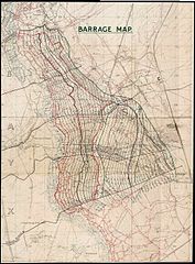
{{Information |Description= High Resolution Barrage Map [Showing Boundaries and Objectives for Assault on Vimy Ridge, Scale [1:10,000] |Source= National Archives of Canada (NMC-111113) |Date= Produced 1917 |Author= 1st Field Survey Company, Royal Engineer
.svg)


