.svg)
File:Vermilion wabashrivermap.png

Size of this preview: 220 × 220 pixels. Other resolutions: 240 × 240 pixels | 375 × 375 pixels | 1,000 × 1,000 pixels.
Original file (1,000 × 1,000 pixels, file size: 554 KB, MIME type: image/png)
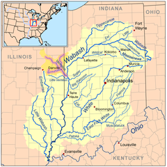
| Description | Map of the Wabash River watershed with the Vermilion River highlighted (including the Salt, Middle, and North forks). |
| Date | |
| Source | Self-made, based on USGS data. |
| Author | Kmusser |
I, the copyright holder of this work, hereby publish it under the following license:
This file is licensed under the Creative Commons Attribution-Share Alike 3.0 Unported license.
- You are free:
- to share – to copy, distribute and transmit the work
- to remix – to adapt the work
- Under the following conditions:
- attribution – You must give appropriate credit, provide a link to the license, and indicate if changes were made. You may do so in any reasonable manner, but not in any way that suggests the licensor endorses you or your use.
- share alike – If you remix, transform, or build upon the material, you must distribute your contributions under the same or compatible license as the original.
File history
Click on a date/time to view the file as it appeared at that time.
| Date/Time | Thumbnail | Dimensions | User | Comment | |
|---|---|---|---|---|---|
| current | 01:15, 4 June 2008 | | 1,000 × 1,000 (554 KB) | wikimediacommons>Kmusser | {{Information |Description=Map of the Wabash River watershed with the Vermilion River highlighted. |Source=Self-made, based on USGS data. |Date=June 3, 2008 |Author= [[User |
File usage
The following page uses this file: