


File:US President John Kennedy Presidential Trips.PNG

Size of this preview: 219 × 96 pixels. Other resolutions: 320 × 140 pixels | 1,425 × 625 pixels.
Original file (1,425 × 625 pixels, file size: 31 KB, MIME type: image/png)

Summary

|
This map image could be re-created using vector graphics as a SVG file. This has several advantages; see Commons:Media for cleanup for more information. If a SVG form of this image is available, please upload it and afterwards replace this template with
{{vector version available|new image name}}.It is recommended to name the SVG file “US President John Kennedy Presidential Trips.svg”—then the template Vector version available (or Vva) does not need the new image name parameter. |
| DescriptionUS President John Kennedy Presidential Trips.PNG |
English: Map showing the foreign trips of John F. Kennedy during his presidency. Svenska: Karta som visar John F. Kennedys utlandsresor under hans presidentskap. |
| Date | (UTC) |
| Source | Own work (Original text: I (Spry895 (talk)) created this work entirely by myself.) |
| Author | Spry895 (talk) |
Licensing
| Public domainPublic domainfalsefalse |

|
This work has been released into the public domain by its author, Spry895 at English Wikipedia. This applies worldwide. In some countries this may not be legally possible; if so: Spry895 grants anyone the right to use this work for any purpose, without any conditions, unless such conditions are required by law.Public domainPublic domainfalsefalse |
Original upload log
Transferred from en.wikipedia to Commons by Vanjagenije using CommonsHelper.
The original description page was here. All following user names refer to en.wikipedia.

- 2010-08-26 15:54 Vanjagenije 1425×625× (50410 bytes) Yugoslavia one country, East and West Germany separate, Czechoslovakia one country, USSR one country, Pakistan and Bangladesh one country, Eritrea part of Ethiopia, North and South Vietnam separate, South and North Yemen separate, West Bank part of Jordan, Federation of Rhodesia and Nyasaland one country,
- 2010-05-12 01:41 Spry895 1425×625× (51520 bytes) {{Information |Description = |Source = I (~~~) created this work entirely by myself. |Date = ~~~~~ |Author = ~~~ |other_versions = }}
Captions
Map showing foreign trips of John F. Kennedy during his presidency
Karta som visar John F. Kennedys utlandsresor under hans presidentskap
File history
Click on a date/time to view the file as it appeared at that time.
| Date/Time | Thumbnail | Dimensions | User | Comment | |
|---|---|---|---|---|---|
| current | 06:50, 11 February 2014 | 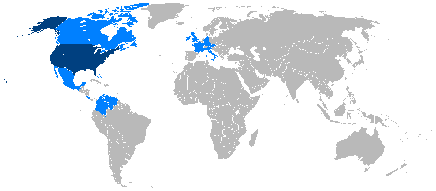 | 1,425 × 625 (31 KB) | smartcommons>Fat&Happy | Failed, try again |
File usage
There are no pages that use this file.
