.svg)
File:The Netherlands compared to sealevel.png

Size of this preview: 220 × 229 pixels. Other resolutions: 230 × 240 pixels | 360 × 375 pixels | 962 × 1,003 pixels.
Original file (962 × 1,003 pixels, file size: 25 KB, MIME type: image/png)
Summary
| Description |
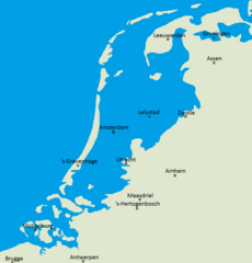
Nederland compared to sealevel. |
| Date | 17 July 2004 (original upload date) |
| Source | Originally from nl.wikipedia; description page is/was here. Reference: http://ahn.geodan.nl/ahn/viewer3/index.html |
| Author | User:Jan Arkesteijn |
| Permission (Reusing this file) |
Own Work. Released into the public domain (by the author). |

|
This map image could be re-created using vector graphics as an SVG file. This has several advantages; see Commons:Media for cleanup for more information. If an SVG form of this image is available, please upload it and afterwards replace this template with
{{vector version available|new image name}}.
It is recommended to name the SVG file “The Netherlands compared to sealevel.svg”—then the template Vector version available (or Vva) does not need the new image name parameter. |
Licensing
| This work has been released into the public domain by its author, Jan Arkesteijn at Dutch Wikipedia. This applies worldwide. In some countries this may not be legally possible; if so: Jan Arkesteijn grants anyone the right to use this work for any purpose, without any conditions, unless such conditions are required by law. |
File history
Click on a date/time to view the file as it appeared at that time.
| Date/Time | Thumbnail | Dimensions | User | Comment | |
|---|---|---|---|---|---|
| current | 15:12, 30 September 2018 | | 962 × 1,003 (25 KB) | wikimediacommons>TanguyP | Fixed city name: Arnhem |
File usage
The following page uses this file: