.svg)
File:The National Archives UK - CO 1069-34-50 1 001.jpg

Original file (839 × 706 pixels, file size: 154 KB, MIME type: image/jpeg)
Summary
| Description |
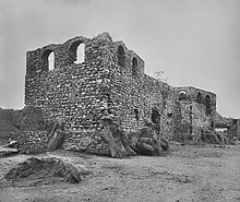
This image is a copy of detail from File:The National Archives UK - CO 1069-34-50.jpg Description: Ruins of Fort Austenborg (Danish) at Jassy. (= The Ruins of Fort Augustaborg at Teshie in the contemporary Ghana.) Location: Jassy (= Teshie) Date: Our Catalogue Reference: Part of CO 1069/34 This image is part of the Colonial Office photographic collection held at The National Archives, uploaded as part of the Africa Through a Lens project. Feel free to share it within the spirit of the Commons. Our records about many of these images are limited. If you have more information about the people, places or events shown in an image, please use the comments section below. We have attempted to provide place information for the images automatically but our software may not have found the correct location. Alternatively you could use the <a href='https://suggestify.appspot.com/'>Suggestify</a> tool to suggest the location of a picture. For high quality reproductions of any item from our collection please contact our <a href='http://www.nationalarchives.gov.uk/imagelibrary' rel='nofollow'>image library</a> |
||
| Date | 1890s (?) | ||
| Source |
|
||
| Author | The National Archives UK - Flickr account |
| Object location | | View this and other nearby images on: OpenStreetMap |
|---|
Licensing
_(St_Edwards_Crown).svg)
|
This file is licensed under the Open Government Licence version 1.0 (OGL v1.0).
|
|---|---|
|
You are free to:
See the Open Government Licence page on Meta-Wiki for more information.
|

|
Attribution information, such as the author's name, e-mail, website, or signature, that was once visible in the image itself has been moved into the image metadata and/or image description page. This makes the image easier to reuse and more language-neutral, and makes the text easier to process and search for. Commons discourages placing visible author information in images.
|
File history
Click on a date/time to view the file as it appeared at that time.
| Date/Time | Thumbnail | Dimensions | User | Comment | |
|---|---|---|---|---|---|
| current | 22:23, 25 August 2015 | | 839 × 706 (154 KB) | wikimediacommons>Edithsme | watermark removed |
File usage
The following page uses this file: