


File:Strathleven House - geograph.org.uk - 1058768.jpg

Original file (640 × 480 pixels, file size: 67 KB, MIME type: image/jpeg)

|
This is a photo of listed building number 115. |
Summary
| DescriptionStrathleven House - geograph.org.uk - 1058768.jpg |
English: Strathleven House. This is another view of a building that is described and illustrated here: 450788.
The nearby doocot is shown here: 1058767. When touring the building on an earlier occasion, I was able to pick up some very detailed material about its history, including architectural plans. Only a very small part of this material is summarized below. Although the detailed reasons would be too lengthy to recount here, it is generally thought that the hand of the architect James Smith can be seen in the design of the building, which was originally called Levenside House. The date above the pediment is 1708, but it seems originally to have read 1700, perhaps indicating two phases of construction (possibly of the main body and then the wings). It was built for William Cochrane of Kilmarnock. When he died in 1717, the house was acquired by Archibald Campbell of Stonefield; it later passed to his son, John Campbell, who died in 1801. In 1830, the house was bought by James Ewing (Provost of Glasgow in 1831); he was responsible for greatly enlarging the estate, and he changed its name, and that of the house, to Strathleven. The house eventually passed to his nephew, Alexander Crum Ewing, and remained in that family until it was compulsorily purchased by the Board of Trade in 1947; it later become a part of Strathleven Industrial Estate. At the time when this photo was submitted, the building was being leased by the Strathleven Regeneration Company, and was being used as a business centre. |
| Date | |
| Source | From geograph.org.uk |
| Author | Lairich Rig |
| Attribution (required by the license) InfoField | Lairich Rig / Strathleven House / |
InfoField | Lairich Rig / Strathleven House |


| Camera location |   | View this and other nearby images on: OpenStreetMap |  55.968930; -4.569900 55.968930; -4.569900 |
|---|
_heading:292.00&language=en)
| Object location | | View this and other nearby images on: OpenStreetMap | 55.969170; -4.571100 |
|---|
_heading:292.00&language=en)
Licensing

|
This image was taken from the Geograph project collection. See this photograph's page on the Geograph website for the photographer's contact details. The copyright on this image is owned by Lairich Rig and is licensed for reuse under the Creative Commons Attribution-ShareAlike 2.0 license.
|


- You are free:
- to share – to copy, distribute and transmit the work
- to remix – to adapt the work
- Under the following conditions:
- attribution – You must give appropriate credit, provide a link to the license, and indicate if changes were made. You may do so in any reasonable manner, but not in any way that suggests the licensor endorses you or your use.
- share alike – If you remix, transform, or build upon the material, you must distribute your contributions under the same or compatible license as the original.
Captions
File history
Click on a date/time to view the file as it appeared at that time.
| Date/Time | Thumbnail | Dimensions | User | Comment | |
|---|---|---|---|---|---|
| current | 07:22, 24 February 2011 | 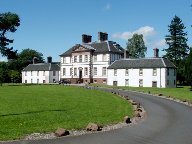 | 640 × 480 (67 KB) | smartcommons>GeographBot | == {{int:filedesc}} == {{Information |description={{en|1=Strathleven House This is another view of a building that is described and illustrated here: 450788. The nearby doocot is shown here: 1058767. When touring the building on an earlier o |
File usage
There are no pages that use this file.
