.svg)
File:State of Burma orthographic map.png

Size of this preview: 220 × 220 pixels. Other resolutions: 240 × 240 pixels | 375 × 375 pixels | 1,000 × 1,000 pixels.
Original file (1,000 × 1,000 pixels, file size: 291 KB, MIME type: image/png)
Summary
| Description |
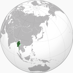
English: Green: Under government authority Light silver: Remainder of Burma Light green: Occupied and annexed by Thailand |
| Date | 11 July 2010 (original upload date) |
| Source | Transferred from en.wikipedia to Commons by Shadowxfox. |
| Author | VoodooIsland at English Wikipedia |
Licensing
| This work has been released into the public domain by its author, VoodooIsland at English Wikipedia. This applies worldwide. In some countries this may not be legally possible; if so: VoodooIsland grants anyone the right to use this work for any purpose, without any conditions, unless such conditions are required by law. |
Original upload log
The original description page was here. All following user names refer to en.wikipedia.
- 2010-07-11 05:45 VoodooIsland 1000×1000× (298377 bytes)
- 2010-07-11 05:45 VoodooIsland 1000×1000× (298184 bytes) '''Green''': Under government authority<br>'''Light silver": Remainder of Burma<br>'''Light green''': Occupied and annexed by [[Thailand]]
File history
Click on a date/time to view the file as it appeared at that time.
| Date/Time | Thumbnail | Dimensions | User | Comment | |
|---|---|---|---|---|---|
| current | 14:36, 6 November 2015 | | 1,000 × 1,000 (291 KB) | wikimediacommons>Xufanc | Correction; removed conflation of Thai army's farthest penetration into Burma accompanying the Japanese from the actual Japanese sanctioned territories east of the Salween annexed by Thailand |
File usage
The following page uses this file: