.svg)
File:South Indian territories.svg

Size of this PNG preview of this SVG file: 220 × 244 pixels. Other resolutions: 216 × 240 pixels | 338 × 375 pixels | 672 × 746 pixels.
Original file (SVG file, nominally 672 × 746 pixels, file size: 306 KB)
Summary
| Description | |
| Date |
7 January 2008 (original upload date) |
| Source |
Own work based on: Hyderabad state 1909.jpg, Bombay Prov south 1909.jpg and Plate 34. Sect. XIII- Madras, Mysore and Goa maps from Constable 1893 Hand Atlas.jpg
|
| Author | AreJay |
| Permission (Reusing this file) |
GFDL, CC-Attrib |
| Other versions |
Derivative works of this file: |
Licensing
AreJay at English Wikipedia, the copyright holder of this work, hereby publishes it under the following licenses:

|
Permission is granted to copy, distribute and/or modify this document under the terms of the GNU Free Documentation License, Version 1.2 or any later version published by the Free Software Foundation; with no Invariant Sections, no Front-Cover Texts, and no Back-Cover Texts. A copy of the license is included in the section entitled GNU Free Documentation License. |
This file is licensed under the Creative Commons Attribution 3.0 Unported license.
Attribution: AreJay at English Wikipedia
- You are free:
- to share – to copy, distribute and transmit the work
- to remix – to adapt the work
- Under the following conditions:
- attribution – You must give appropriate credit, provide a link to the license, and indicate if changes were made. You may do so in any reasonable manner, but not in any way that suggests the licensor endorses you or your use.
You may select the license of your choice.
Original upload log
Transferred from en.wikipedia to Commons by Kelly using CommonsHelper.
The original description page was here. All following user names refer to en.wikipedia.
- 2008-04-11 04:19 AreJay 693×748×0 (724956 bytes) '
- 2008-01-09 03:46 AreJay 693×747×0 (599498 bytes) '
- 2008-01-09 03:45 AreJay 693×747×0 (600270 bytes) '
- 2008-01-09 03:43 AreJay 693×747×0 (600126 bytes) '
- 2008-01-09 03:36 AreJay 693×747×0 (600077 bytes) '
- 2008-01-09 03:21 AreJay 693×801×0 (603408 bytes) changes
- 2008-01-08 01:02 AreJay 690×726×0 (615193 bytes) cleanup
- 2008-01-07 18:22 AreJay 690×726×0 (615142 bytes) corrected spelling error
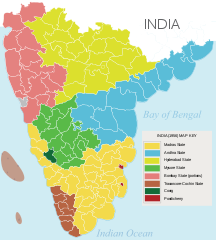
- 2008-01-07 02:35 AreJay 690×726×0 (615141 bytes) {{Information |Description= [[South India]]n states prior to the ''[[States Reorganisation Act]]'' (1956) |Source=self-made |Date= Jan 6, 2008 |Location= Atlanta, GA, USA |Author= [[User:AreJay|]] |Permission= GFDL, CC-Attrib |other_versions={{DerivativeVersions|South Indian territories 2009 de.svg}} }}
File history
Click on a date/time to view the file as it appeared at that time.
| Date/Time | Thumbnail | Dimensions | User | Comment | |
|---|---|---|---|---|---|
| current | 05:07, 24 November 2014 | | 672 × 746 (306 KB) | wikimediacommons>Ras67 | black frame and Illustrator data removed |
File usage
The following 12 pages use this file: