.svg)
File:South Asia historical AD550 EN.svg

Size of this PNG preview of this SVG file: 220 × 215 pixels. Other resolutions: 246 × 240 pixels | 384 × 375 pixels | 1,280 × 1,250 pixels.
Original file (SVG file, nominally 1,280 × 1,250 pixels, file size: 787 KB)
Summary
| Description |
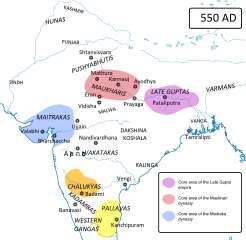
English: Political map of India around 550 AD, just after the collapse of the imperial power of the Guptas. The Hunas (Hephtalites) have been driven back to Gandhara. In the north, former Gupta vassals become independent. In the south, Pulakesin I has founded the Chalukya empire.
Sources:
South Asia historical
|
| Date | |
| Source | Own work |
| Author | Woudloper |
| Other versions |
Nederlands  |


Licensing
I, the copyright holder of this work, hereby publish it under the following license:
This file is licensed under the Creative Commons Attribution-Share Alike 4.0 International license.
- You are free:
- to share – to copy, distribute and transmit the work
- to remix – to adapt the work
- Under the following conditions:
- attribution – You must give appropriate credit, provide a link to the license, and indicate if changes were made. You may do so in any reasonable manner, but not in any way that suggests the licensor endorses you or your use.
- share alike – If you remix, transform, or build upon the material, you must distribute your contributions under the same or compatible license as the original.
File history
Click on a date/time to view the file as it appeared at that time.
| Date/Time | Thumbnail | Dimensions | User | Comment | |
|---|---|---|---|---|---|
| current | 23:29, 30 August 2014 | | 1,280 × 1,250 (787 KB) | wikimediacommons>Woudloper | try again |
File usage
There are no pages that use this file.