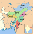
File:SevenSisterStates.svg

From Bharatpedia, an open encyclopedia

Original file(SVG file, nominally 606 × 615 pixels, file size: 1 MB)

This file is from Wikimedia Commons and may be used by other projects. The description on its file description page there is shown below.

Summary

Description
If you can, help make this description accessible to all by translating it into other languages. – Thanks!
Dansk: Kort over det nordøstlige Indien.
Deutsch: Karte von Nordostindien.
English: Map of Northeast India.
বাংলা: উত্তর-পূর্ব ভারত
Date
Source This file was derived from: SevenSisterStates.png
 
Author Furfur
Permission
(Reusing this file)
w:en:Creative Commons
attribution share alike
This file is licensed under the Creative Commons Attribution-Share Alike 3.0 Unported license.
You are free:
  • to share – to copy, distribute and transmit the work
  • to remix – to adapt the work
Under the following conditions:
  • attribution – You must give appropriate credit, provide a link to the license, and indicate if changes were made. You may do so in any reasonable manner, but not in any way that suggests the licensor endorses you or your use.
  • share alike – If you remix, transform, or build upon the material, you must distribute your contributions under the same or compatible license as the original.
Other versions

[edit]

SVG development
InfoField
 
The SVG code is valid.
 
This map was created with Adobe Illustrator.

Captions

Map of Northeast India

Items portrayed in this file

depicts

6 January 2014

File history

Click on a date/time to view the file as it appeared at that time.

Date/TimeThumbnailDimensionsUserComment
current17:27, 28 December 2018Thumbnail for version as of 17:27, 28 December 2018606 × 615 (1 MB)wikimediacommons>JoKalliauer1)Phab:T184369 and 2)Arial not available: font-family="'ArialMT'" should be replaced with font-family="Liberation Sans,ArialMT"

The following 2 pages use this file: