.svg)
File:SalernoDDayPlans1943.jpg

Size of this preview: 220 × 152 pixels. Other resolutions: 320 × 221 pixels | 500 × 345 pixels | 1,200 × 829 pixels.
Original file (1,200 × 829 pixels, file size: 342 KB, MIME type: image/jpeg)
Summary
| Description |
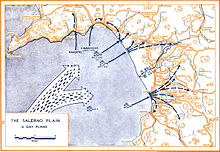
English: Plans for Allied Landings at Salerno 9 September 1943 |
| Date | |
| Source | http://www.history.army.mil/books/wwii/salerno/sal-maps.htm#m2 |
| Author | Historical Division, US War Department |
| Location | +40° 28' 56.90", +14° 48' 48.46" |
Extracted from SALERNO American Operations From the Beaches to the Volturno 9 September - 6 October 1943. Center of Military History Publication 100-7
Licensing
This file is a work of a U.S. Army soldier or employee, taken or made as part of that person's official duties. As a work of the U.S. federal government, it is in the public domain in the United States.
|
 |
File history
Click on a date/time to view the file as it appeared at that time.
| Date/Time | Thumbnail | Dimensions | User | Comment | |
|---|---|---|---|---|---|
| current | 02:01, 24 November 2009 | | 1,200 × 829 (342 KB) | wikimediacommons>Hohum | Levels, clarified. |
File usage
The following 2 pages use this file: