.svg)
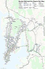
File:Rapid transit map of Mumbai.jpg

Size of this preview: 215 × 330 pixels. Other resolutions: 156 × 240 pixels | 244 × 375 pixels | 4,150 × 6,363 pixels.
Original file (4,150 × 6,363 pixels, file size: 5.82 MB, MIME type: image/jpeg)
Summary
| Description |
|
| Date | see file history |
| Source | Own work using: OpenStreetMap data for the background |
| Author | Maximilian Dörrbecker (Chumwa) |
| Permission (Reusing this file) |
All OpenStreetMap data and maps are Creative Commons "CC-BY-SA 2.0" licensed This file is licensed under the Creative Commons Attribution-Share Alike 2.0 Generic license.
|
File history
Click on a date/time to view the file as it appeared at that time.
| Date/Time | Thumbnail | Dimensions | User | Comment | |
|---|---|---|---|---|---|
| current | 13:10, 6 April 2022 | | 4,150 × 6,363 (5.82 MB) | wikimediacommons>BasilLeaf | Update - Lines 2 and 7 opened partially (Line 2 station names + Line colours need updating) |
File usage
The following 3 pages use this file: