.svg)
File:Rajendra map new.png

Size of this preview: 220 × 157 pixels. Other resolutions: 320 × 229 pixels | 466 × 333 pixels.
Original file (466 × 333 pixels, file size: 84 KB, MIME type: image/png)
The Chola Dynasty:16, 21 March 2011
Summary
| Description |
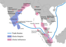
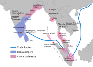
English: Map showing the extent of the Chola empire during Rajendra Chola I (c. 1030 CE)
The file has changed from the original. The correction about the Chola influence in Malay areas is based on https://archive.org/details/earlykingdomsofi0000muno/page/118/mode/2up The influence added the area of Lamuri based on Tanjore inscription. Andaman is deleted leaving only Nicobar (information on Tanjore inscription). |
| Date | 30 October 2006 (original upload date) |
| Source | Transferred from en.wikipedia to Commons by Maukie. |
| Author | Venu62 at English Wikipedia |

|
File:Rajendra map new.svg is a vector version of this file. It should be used in place of this PNG file when not inferior.
File:Rajendra map new.png → File:Rajendra map new.svg
For more information, see Help:SVG. |
 |
Licensing
Venu62 at the English-language Wikipedia, the copyright holder of this work, hereby publishes it under the following license:
| This file is licensed under the Creative Commons Attribution-Share Alike 3.0 Unported license. Subject to disclaimers. | ||
| Attribution: Venu62 at the English-language Wikipedia | ||
| ||
| This licensing tag was added to this file as part of the GFDL licensing update. |

|
Permission is granted to copy, distribute and/or modify this document under the terms of the GNU Free Documentation License, Version 1.2 or any later version published by the Free Software Foundation; with no Invariant Sections, no Front-Cover Texts, and no Back-Cover Texts. A copy of the license is included in the section entitled GNU Free Documentation License. Subject to disclaimers. |
Original upload log
The original description page was here. All following user names refer to en.wikipedia.
- 2006-10-30 00:31 Venu62 629×442× (215021 bytes) Map showing th extent of the [[Chola empire]] during [[Rajendra Chola I]] (c. 1030 CE)
File history
Click on a date/time to view the file as it appeared at that time.
| Date/Time | Thumbnail | Dimensions | User | Comment | |
|---|---|---|---|---|---|
| current | 06:45, 12 January 2024 | | 466 × 333 (84 KB) | wikimediacommons>Surijeal | Reverted to version as of 11:38, 29 November 2022 (UTC) Vandalism, no reason given for reversion |
File usage
The following 4 pages use this file: