.svg)
File:Punjabdoabs1.jpg

Size of this preview: 220 × 158 pixels. Other resolutions: 320 × 229 pixels | 500 × 358 pixels | 1,583 × 1,135 pixels.
Original file (1,583 × 1,135 pixels, file size: 268 KB, MIME type: image/jpeg)


Summary

|
This locator map image could be re-created using vector graphics as an SVG file. This has several advantages; see Commons:Media for cleanup for more information. If an SVG form of this image is available, please upload it and afterwards replace this template with
{{vector version available|new image name}}.
It is recommended to name the SVG file “Punjabdoabs1.svg”—then the template Vector version available (or Vva) does not need the new image name parameter. |

|
This file has been superseded by PunjabDoabs.png. It is recommended to use the other file. Please note that deleting superseded images requires consent.
|

|
| Description |
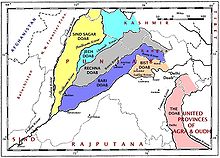
English: This map of the doabs is based on the map in the paper, "Partition of the Punjab and of Bengal," by O. H. G. Spate, The Geographical Journal, 110(4-6):201-218, November 1947. The journal was published in the United Kingdom. |
| Date | |
| Source | Own work |
| Author | Fowler&fowler |
Licensing
I, the copyright holder of this work, hereby publish it under the following licenses:
This file is licensed under the Creative Commons Attribution-Share Alike 3.0 Unported license.
- You are free:
- to share – to copy, distribute and transmit the work
- to remix – to adapt the work
- Under the following conditions:
- attribution – You must give appropriate credit, provide a link to the license, and indicate if changes were made. You may do so in any reasonable manner, but not in any way that suggests the licensor endorses you or your use.
- share alike – If you remix, transform, or build upon the material, you must distribute your contributions under the same or compatible license as the original.

|
Permission is granted to copy, distribute and/or modify this document under the terms of the GNU Free Documentation License, Version 1.2 or any later version published by the Free Software Foundation; with no Invariant Sections, no Front-Cover Texts, and no Back-Cover Texts. A copy of the license is included in the section entitled GNU Free Documentation License. |
You may select the license of your choice.
File history
Click on a date/time to view the file as it appeared at that time.
| Date/Time | Thumbnail | Dimensions | User | Comment | |
|---|---|---|---|---|---|
| current | 04:48, 5 February 2009 | | 1,583 × 1,135 (268 KB) | wikimediacommons>Fowler&fowler | {{Information |Description={{en|1=This map of the ''doabs'' is based on the map in the paper, "Partition of the Punjab and of Bengal," by O. H. G. Spate, The Geographical Journal, 110(4-6):201-218, November 1947. The journal was published in the Unit |
File usage
The following 11 pages use this file: