.svg)
File:Population Density, v4.11, 2020 (48009093621).jpg

Size of this preview: 220 × 161 pixels. Other resolutions: 320 × 234 pixels | 500 × 365 pixels | 3,053 × 2,231 pixels.
Original file (3,053 × 2,231 pixels, file size: 622 KB, MIME type: image/jpeg)
.jpg)
Summary
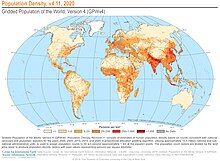
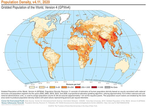
| Description | Gridded Population of the World, Version 4 (GPWv4): Population Density, Revision 11 consists of estimates of human population density based on counts consistent with national censuses and population registers for the years 2000, 2005, 2010, 2015, and 2020. A proportional allocation gridding algorithm, utilizing approximately 13.5 million national and sub-national administrative units, is used to assign population counts to 30 arc-second (approximately 1 km at the equator) pixels. The population count rasters are divided by the land area raster to produce population density rasters with pixel values representing persons per square kilometer. |
| Date | |
| Source | Population Density, v4.11, 2020 |
| Author | SEDACMaps |
Licensing
This file is licensed under the Creative Commons Attribution 2.0 Generic license.
- You are free:
- to share – to copy, distribute and transmit the work
- to remix – to adapt the work
- Under the following conditions:
- attribution – You must give appropriate credit, provide a link to the license, and indicate if changes were made. You may do so in any reasonable manner, but not in any way that suggests the licensor endorses you or your use.
| This image was originally posted to Flickr by SEDACMaps at https://flickr.com/photos/54545503@N04/48009093621 (archive). It was reviewed on 21 December 2019 by FlickreviewR 2 and was confirmed to be licensed under the terms of the cc-by-2.0. |
File history
Click on a date/time to view the file as it appeared at that time.
| Date/Time | Thumbnail | Dimensions | User | Comment | |
|---|---|---|---|---|---|
| current | 06:34, 27 November 2022 | | 3,053 × 2,231 (622 KB) | wikimediacommons>BluePenguin18 | Updating with 2018 info and cropping redundant copyright licence |
File usage
There are no pages that use this file.
.jpg)