


File:OCHAoPT 2018 Gaza border protests 31 may 2018.png

Original file (628 × 491 pixels, file size: 71 KB, MIME type: image/png)

Summary
| DescriptionOCHAoPT 2018 Gaza border protests 31 may 2018.png |
English: OCHAoPT map of 2018 Gaza border protests, as at 31 May 2018 |
| Date | |
| Source | https://www.ochaopt.org/content/humanitarian-snapshot-casualties-context-demonstrations-and-hostilities-gaza-30-march-12-0 |
| Author | OCHAoPT |
Licensing
| Public domainPublic domainfalsefalse |

|
This image is a map derived from a United Nations map.
Unless stated otherwise, UN maps are to be considered in the public domain. This applies worldwide. UN maps are, in principle, open source material and you can use them in your work or for making your own map. UN requests however that you delete the UN name, logo and reference number upon any modification to the map. Content of your map will be your responsibility. You can state in your publication, if you wish, something like: based on UN map … (map name, map number, revision number and date). See: Geospatial Information Section. And: Geospatial, location data for a better world. |
 |
Captions
File history
Click on a date/time to view the file as it appeared at that time.
| Date/Time | Thumbnail | Dimensions | User | Comment | |
|---|---|---|---|---|---|
| current | 20:31, 3 June 2018 | 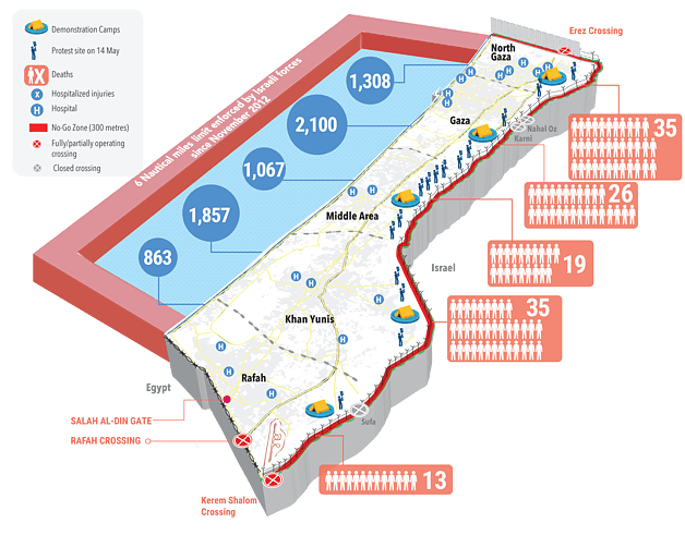 | 628 × 491 (71 KB) | (username removed) |
File usage
The following page uses this file:
