


File:NorthAmerica1763-A.png

Size of this preview: 220 × 168 pixels. Other resolutions: 315 × 240 pixels | 787 × 600 pixels.
Original file (787 × 600 pixels, file size: 43 KB, MIME type: image/png)

Summary
| DescriptionNorthAmerica1763-A.png |
English: Map showing the North American territorial gains of Spain in 1762 and Britain in 1763. |
| Date | |
| Source | Own work by uploader, base map used is found here, uploaded by User:Roke |
| Author | AlexiusHoratius |

Licensing
I, the copyright holder of this work, hereby publish it under the following licenses:


This file is licensed under the Creative Commons Attribution-Share Alike 3.0 Unported license.
- You are free:
- to share – to copy, distribute and transmit the work
- to remix – to adapt the work
- Under the following conditions:
- attribution – You must give appropriate credit, provide a link to the license, and indicate if changes were made. You may do so in any reasonable manner, but not in any way that suggests the licensor endorses you or your use.
- share alike – If you remix, transform, or build upon the material, you must distribute your contributions under the same or compatible license as the original.

|
Permission is granted to copy, distribute and/or modify this document under the terms of the GNU Free Documentation License, Version 1.2 or any later version published by the Free Software Foundation; with no Invariant Sections, no Front-Cover Texts, and no Back-Cover Texts. A copy of the license is included in the section entitled GNU Free Documentation License.http://www.gnu.org/copyleft/fdl.htmlGFDLGNU Free Documentation Licensetruetrue |
You may select the license of your choice.
Notes
- The pink coloring specifically designates territory that Britain held without question after 1763; included are both areas that had been under full Spanish or French control and then lost, as well as areas disputedly claimed by Britain before 1763.
- Florida was held by Spain prior to 1763; on the map it is shown only as a British gain, and appears no different from territory lost by France.
- The undefined boundary in the upper watershed of the Red River of the North was due to confusion at the time as to the location of the headwaters of the Mississippi River. (The source of the Mississippi was believed to have been further north than its actual location.)
Captions
Add a one-line explanation of what this file represents
File history
Click on a date/time to view the file as it appeared at that time.
| Date/Time | Thumbnail | Dimensions | User | Comment | |
|---|---|---|---|---|---|
| current | 05:46, 26 September 2008 | 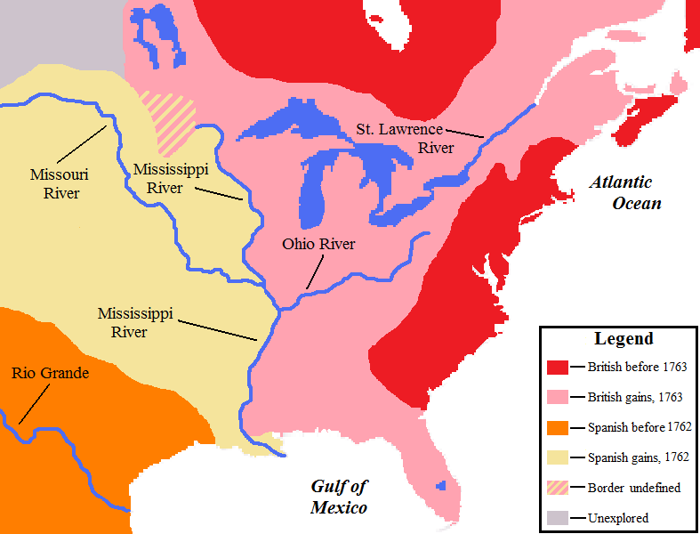 | 787 × 600 (43 KB) | smartcommons>AlexiusHoratius~commonswiki | {{Information |Description={{en|1=Map showing the territorial gains by Britain and Spain in North America in 1762 and 1763.}} |Source=Own work by uploader |Author=AlexiusHoratius |Date=25 September 2008 |Permission= |other_version |
File usage
There are no pages that use this file.
