.svg)
File:Neer-Mahal.jpg
Original file (511 × 285 pixels, file size: 78 KB, MIME type: image/jpeg)
Summary
| Description |
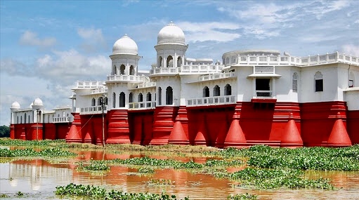
English: Neermahal (meaning "Water Palace") is a beautiful historical place which was built by 90 years ago the former royal King Bir Bikram Kishore Manikya Bahadur of the erstwhile Kingdom of Tripura, Neer-Mahal in the middle of the lake Rudrasagar in 1930 and was completed by 1938. It is situated in Melaghar, 53 kilometers away from Agartala, the capital of Tripura. The palace is situated in the middle of Rudrasagar Lake and assimilates Hindu and Muslim architectural styles.Now a days it is popularly known as tourists sport in every festival of different communities people visit there.
বাংলা: নীরমহল |
| Date | |
| Source | Own work |
| Author | Babulmiah12 |
| Camera location | | View this and other nearby images on: OpenStreetMap |
|---|
The palace is the largest of its kind in India and the only one in Eastern India. There are only two water palace in India another one is the Jal Mahal in Rajasthan.
Known as ‘lake palace’ of Tripura,Rajghat .Neer-Mahal was constructed as a summer residence for king of Tripura.It was Maharaja Bir Bikram Manikya Bahadur’s idea to build a palace in the beautiful Rudrasagar lake and in 1921 he accredited the British company Martin and Burns to construct the palace for him. The company took nine years to complete the work. Maharaja Bir Bikram Manikya Bahadur belonged to the ‘Manikya Dynasty’ which is supposed to be the second from a single line in the world today.
Licensing
- You are free:
- to share – to copy, distribute and transmit the work
- to remix – to adapt the work
- Under the following conditions:
- attribution – You must give appropriate credit, provide a link to the license, and indicate if changes were made. You may do so in any reasonable manner, but not in any way that suggests the licensor endorses you or your use.
- share alike – If you remix, transform, or build upon the material, you must distribute your contributions under the same or compatible license as the original.

|
This image was uploaded as part of Wiki Loves Monuments 2018.
|
 |
File history
Click on a date/time to view the file as it appeared at that time.
| Date/Time | Thumbnail | Dimensions | User | Comment | |
|---|---|---|---|---|---|
| current | 11:17, 1 September 2018 | | 511 × 285 (78 KB) | wikimediacommons>Babulmiah12 | User created page with UploadWizard |