.svg)
File:Mycenaean World en.png

Size of this preview: 220 × 193 pixels. Other resolutions: 274 × 240 pixels | 427 × 375 pixels | 1,242 × 1,090 pixels.
Original file (1,242 × 1,090 pixels, file size: 897 KB, MIME type: image/png)
Summary
| Description |
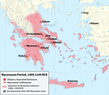
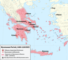
English: Map of Mycenaean Greece 1400-1200 BC: Palaces, main cities and other settlements.
Ελληνικά: Χάρτης του Μυκηναϊκού πολιτισμού 1400-1200 π.Χ. (ανάκτορα, εγκαταστάσεις κλπ.) |
| Date | |
| Source | Ιστορία του Ελληνικού Έθνους, Εκδοτική Αθηνών, τ. Α' χάρτες σε σελ. 263-265, σελ. 290, 292-293 (επίσης [1] |
| Author | User:Alexikoua, User:Panthera tigris tigris, TL User:Reedside |
| Other versions |
[]
|


![[1]](https://upload.wikimedia.org/wikipedia/commons/4/4d/AlterOrient2.png)
Licensing
This file is licensed under the Creative Commons Attribution-Share Alike 3.0 Unported license.
- You are free:
- to share – to copy, distribute and transmit the work
- to remix – to adapt the work
- Under the following conditions:
- attribution – You must give appropriate credit, provide a link to the license, and indicate if changes were made. You may do so in any reasonable manner, but not in any way that suggests the licensor endorses you or your use.
- share alike – If you remix, transform, or build upon the material, you must distribute your contributions under the same or compatible license as the original.
File history
Click on a date/time to view the file as it appeared at that time.
| Date/Time | Thumbnail | Dimensions | User | Comment | |
|---|---|---|---|---|---|
| current | 06:28, 6 August 2017 | | 1,242 × 1,090 (897 KB) | wikimediacommons>Reedside | User created page with UploadWizard |
File usage
The following page uses this file: