.svg)
File:Mussoorie and Landour, 1860s.jpg

Original file (4,000 × 2,274 pixels, file size: 3.23 MB, MIME type: image/jpeg)
Summary
| Description | Mussoorie and Landour, 1860s.jpg |
| Date | 1860s |
| Source | General view of Mussoorie and Landour |
| Author | Samuel Bourne |
== Licensing ==(c) The British Library Board. All Rights Reserved
|
This work is in the public domain in its country of origin and other countries and areas where the copyright term is the author's life plus 70 years or fewer. This work is in the public domain in the United States because it was published (or registered with the U.S. Copyright Office) before January 1, 1930. | |
| This file has been identified as being free of known restrictions under copyright law, including all related and neighboring rights. | |
Description from the Original
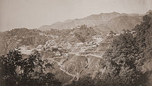
View of Mussorie and Landour, taken by Samuel Bourne in the 1860s. Mussorie in the Himalayas is perched on a horseshoe shaped ridge above the Doon valley at a height of 2,002 m. It has been a popular hill station since the1820s when the British military officer Captain Young laid the foundations of this town. Landour to the east of Musssorie, connected to it by a narrow spur, was a barracks and convalescence area for British soldiers. Landour hill rises 273 m above Mussorie. The Image is the Copyright of The British Library.
File history
Click on a date/time to view the file as it appeared at that time.
| Date/Time | Thumbnail | Dimensions | User | Comment | |
|---|---|---|---|---|---|
| current | 09:27, 31 March 2012 | | 4,000 × 2,274 (3.23 MB) | wikimediacommons>Aavindraa | larger |