File:Mongol Empire map.gif
Size of this preview: 220 × 173 pixels. Other resolutions: 306 × 240 pixels | 477 × 375 pixels | 752 × 591 pixels.
Original file (752 × 591 pixels, file size: 162 KB, MIME type: image/gif, looped, 9 frames, 9.0 s)
Summary
| Description |
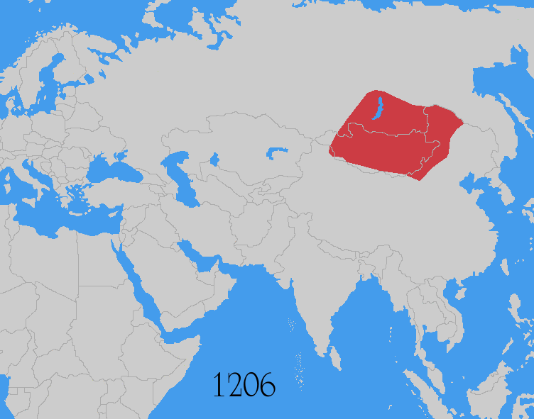
Map showing changes in borders of the Mongol Empire from founding by Genghis Khan in 1206, Genghis Khan's death in 1227 to the rule of Kublai Khan (1260–1294). (Uses modern day borders) Mongol Empire
By 1294 the empire had split into: Yuan Dynasty (Great Khanate) |
| Date | |
| Source | Based on the freely licenced Image:Genghis khan empire at his death.png using information from maps of the Mongol Empire in atlases and on the web such as [1], [2], [3], [4], [5]. Made in Photoshop and Painter. |
| Author | User:Astrokey44 |
| Permission (Reusing this file) |
self made |
| Other versions |
Derivative works of this file: Mongol Empire map 2.gif other maps on commons - same animation but with alternative colours, greatest extent, Mongol dominions, 1294 |
![[1]](http://www.silk-road.com/maps/images/mongol.jpg)
![[2]](http://www.loyno.edu/~seduffy/MapImages/MongolEmpire-display.jpg)
![[3]](http://www.siu.edu/~dfll/Chinese/mongol.jpg)
![[4]](http://www.allempires.com/empires/mongol/mongolempire_map.jpg)
![[5]](http://www.tiscali.co.uk/reference/encyclopaedia/hutchinson/images/c01786.jpg)
Licensing
I, the copyright holder of this work, hereby publish it under the following licenses:

|
Permission is granted to copy, distribute and/or modify this document under the terms of the GNU Free Documentation License, Version 1.2 or any later version published by the Free Software Foundation; with no Invariant Sections, no Front-Cover Texts, and no Back-Cover Texts. A copy of the license is included in the section entitled GNU Free Documentation License. |
| This file is licensed under the Creative Commons Attribution-Share Alike 3.0 Unported license. | ||
| ||
| This licensing tag was added to this file as part of the GFDL licensing update. |
This file is licensed under the Creative Commons Attribution-Share Alike 2.5 Generic, 2.0 Generic and 1.0 Generic license.
- You are free:
- to share – to copy, distribute and transmit the work
- to remix – to adapt the work
- Under the following conditions:
- attribution – You must give appropriate credit, provide a link to the license, and indicate if changes were made. You may do so in any reasonable manner, but not in any way that suggests the licensor endorses you or your use.
- share alike – If you remix, transform, or build upon the material, you must distribute your contributions under the same or compatible license as the original.
You may select the license of your choice.
Additional sources
- For the Ilkhanate: Roolvink, R. (2007) Historical Atlas of the Muslim Peoples, Taylor and Francis, p. 26 ISBN: 9780415440943.
- Mongol dominions, 1226–1405: Shepherd, William Robert; C.S. Hammond & Company (1964) Historical atlas, Barnes & Noble, p. 92
- McKitterick, Rosamond (2003) Atlas of the medieval world, Oxford University Press, pp. 174–175 ISBN: 9780195221589.
| Annotations | This image is annotated: View the annotations at Commons |
File history
Click on a date/time to view the file as it appeared at that time.
| Date/Time | Thumbnail | Dimensions | User | Comment | |
|---|---|---|---|---|---|
| current | 12:37, 30 July 2014 | | 752 × 591 (162 KB) | wikimediacommons>Sven Manguard | As per Commons:Overwriting existing files |
File usage
The following 2 pages use this file: