.svg)
File:Mauna Loa atmospheric transmission.png
Size of this preview: 220 × 165 pixels. Other resolutions: 320 × 240 pixels | 500 × 375 pixels | 640 × 480 pixels.
Original file (640 × 480 pixels, file size: 31 KB, MIME type: image/png)

|
This graph image could be re-created using vector graphics as an SVG file. This has several advantages; see Commons:Media for cleanup for more information. If an SVG form of this image is available, please upload it and afterwards replace this template with
{{vector version available|new image name}}.
It is recommended to name the SVG file “Mauna Loa atmospheric transmission.svg”—then the template Vector version available (or Vva) does not need the new image name parameter. |
Summary
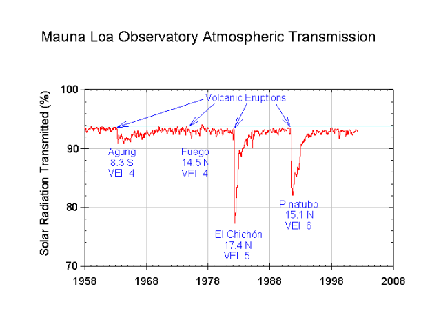
English: Mauna Loa Observatory atmospheric transmission. Reduced solar radiation due to volcanic aerosols labeled.
Español: Transmisión atmosférica del Observatorio de Mauna Loa en Hawaii. Reducción de la radiación solar debido a las erupciones volcánicas del Monte Agung (1963, Indonesia), Volcán de Fuego (1974, Guatemala), El Chichón (1982, México), Monte Pinatubo (1991, Filipinas).
This image is in the public domain because it contains materials that originally came from the U.S. National Oceanic and Atmospheric Administration, taken or made as part of an employee's official duties.
|
Source: http://www.cmdl.noaa.gov/albums/cmdl_overview/Slide18.sized.png archive copy at the Wayback Machine
File history
Click on a date/time to view the file as it appeared at that time.
| Date/Time | Thumbnail | Dimensions | User | Comment | |
|---|---|---|---|---|---|
| current | 16:32, 18 June 2005 | | 640 × 480 (31 KB) | wikimediacommons>Kokoo | Mauna Loa Observatory atmospheric transmission. Reduced solar radiation due to volcanic aerosols labeled. {{PD-USGov-DOC-NOAA}} Source: http://www.cmdl.noaa.gov/albums/cmdl_overview/Slide18.sized.png |
File usage
The following 2 pages use this file: