


File:Map of Rohingya people in Rakhine State.png

Size of this preview: 189 × 329 pixels. Other resolutions: 138 × 240 pixels | 651 × 1,132 pixels.
Original file (651 × 1,132 pixels, file size: 61 KB, MIME type: image/png)

Summary
| DescriptionMap of Rohingya people in Rakhine State.png |
English: Rohingya people in Rakhine (Arakan) State in Myanmar. |
| Date | |
| Source | Own work |
| Author | WikiEditor2004 |
Licensing
I, the copyright holder of this work, hereby publish it under the following license:
 
|
This file is made available under the Creative Commons CC0 1.0 Universal Public Domain Dedication. |
| The person who associated a work with this deed has dedicated the work to the public domain by waiving all of their rights to the work worldwide under copyright law, including all related and neighboring rights, to the extent allowed by law. You can copy, modify, distribute and perform the work, even for commercial purposes, all without asking permission.
http://creativecommons.org/publicdomain/zero/1.0/deed.enCC0Creative Commons Zero, Public Domain Dedicationfalsefalse |
References
Demographic data:
- http://reliefweb.int/report/myanmar/humanitarian-crisis-deepens-arakan-state ("This is in contrast to Buthidaung and Maungdaw townships which have a large Rohingya majority.") Archived March 4, 2016, at the Wayback Machine
- http://csis.org/publication/separating-fact-fiction-about-myanmars-rohingya ("Most of this population lives in the townships of Maungdaw and Buthidaung, where Rohingya are the majority") Archived April 27, 2024, at the Wayback Machine
- http://sometimemaybe.blogspot.com/2009/07/burma-ii.html Archived October 16, 2010, at the Wayback Machine("Fear is said to reign not only in Rakhine towns and villages but also areas with Rohingya majorities—including Maungdaw Township, where more than 90 percent of the 493,000 inhabitants are Rohingya."..."One other township in Arakan State has a large Rohingya majority—Buthidaung, where more than 80 percent of the 279,000 inhabitants are Rohingya.")
- https://rohingyathai.blogspot.com/2012/08/mass-graves-for-myanmar-rohingyas.html Archived November 22, 2023, at the Wayback Machine("or even the local busses that run Buthidaung to Maungdaw, two Rohingya-majority states.")
- https://www.crisisgroup.org/asia/south-east-asia/myanmar/339-breaking-away-battle-myanmars-rakhine-state Archived August 31, 2024, at the Wayback Machine("The Rohingya community in Rakhine State is not homogeneous. In northern Rakhine, where the Rohingya are a majority, some of them are more hostile to the idea of Arakan Army rule than those in central Rakhine, where the Rohingya are a minority.")
- https://thediplomat.com/2024/10/rohingya-community-is-divided-over-arakan-armys-plan-for-inclusive-administration/Archived January 25, 2025, at the Wayback Machine("Minbya is a township with 36,235 Rohingya inhabitants across 15 villages..")
- http://www.aljazeera.com/indepth/features/2012/08/201288114724103607.html Archived July 7, 2022, at the Wayback Machine("or even the local busses that run from Buthidaung to Maungdaw, two Rohingya-majority states.")
- https://www.hrw.org/news/2012/11/17/burma-satellite-images-show-widespread-attacks-rohingya Archived November 1, 2020, at the Wayback Machine("All four districts of Arakan State – Sittwe, Maungdaw, Kyauk Pyu, and Thandwe – have experienced violence since June 2012. Violence between Arakanese Buddhists and Rohingya Muslims reignited on October 21 and continued to some extent all week in 9 of the state’s 17 townships: Pauktaw, Mrauk-U, Myebon, Kyauk Pyu, Ramree, Kyauktaw, Minbya, Rathedaung, and Thandwe. Four other townships experienced serious violence in June and thereafter: Sittwe, Maungdaw, Buthidaung, and Toungop.")
- http://www.restlessbeings.org/projects/rohingya/burmese-army-allow-further-2300-rohingya-to-become-displaced[dead link] ("This second round of violence that began on the 21st of October were targeted at more remote villages where, whilst Rohingya villages were found, the townships were largely Rakhine populated. In Minbya, Mrauk Oo, Pauk Taw, Kyauk Taw, Kyauk Pyu and Rathedaung.")
- http://hlaoo1980.blogspot.com/2012/06/bengali-cleansing-in-arrakan.html Archived October 4, 2022, at the Wayback Machine("There are 17 townships in the Arrakan State. Except the Bengali-free Taunggup, Ann, and Gwa townships Bengali immigrants from the extremely-crowded Bangladesh across the border inhabit the 14 townships together with the native Buddhist Yakhines.")
- http://loveandntolerance.blogspot.com/2012/10/the-concrete-solution-for-rohingya.html ("Nearly one million Rohingyas in 14 townships of Arakan State") Archived November 24, 2023, at the Wayback Machine
- https://rohingyaonlinenewsgroup.wordpress.com/2012/10/28/president-thein-sein-ready-to-declare-a-new-rule-of-law-in-rakhine-state/ Archived January 23, 2025, at the Wayback Machine("Before and since the timely establishment of the RNDP party, its ultimate goal has been to drive out Rohingya Muslims from all 14 townships of Rakhine state and then to establish The Great Rakhine Union State")
- https://www.usatoday.com/story/news/world/2013/03/30/myanmar-govt-religious-riots/2037853/ Archived April 4, 2013, at the Wayback Machine("It said there were 163 incidents of violence in 15 townships in the country")
Maps of Rakhine State:
- http://www.myanmars.net/myanmar-map/rakhine.jpg archive copy at the Wayback Machine
- http://www.edenhilltravels.com/wp-content/uploads/2013/08/rakhine-modified.jpg archive copy at the Wayback Machine
- http://www.rfa.org/english/news/myanmar/violence-10252012182913.html/rakhine-map-new-390.jpg archive copy at the Wayback Machine
- http://www.asterism.info/states/7/map.jpg archive copy at the Wayback Machine
- http://www.allthingsburmese.com/images/Rakhine%20State%20Map.gif [dead link]
- http://www.guideformyanmar.com/images/touristplace/rakhine_state.jpg archive copy at the Wayback Machine
- https://arakanindobhasa.files.wordpress.com/2009/11/12.jpg archive copy at the Wayback Machine
- http://reliefweb.int/sites/reliefweb.int/files/resources/map_2466.pdf archive copy at the Wayback Machine
- http://maps.maphill.com/burma/arakan-rakhine/maps/savanna-style-map/savanna-style-map-of-arakan-rakhine.jpg Archived 2016-03-17 at the Wayback Machine
- http://maps.maphill.com/burma/arakan-rakhine/maps/satellite-map/cropped-outside/satellite-map-of-arakan-rakhine-cropped-outside.jpg Archived 2024-12-22 at the Wayback Machine
- http://maps.maphill.com/burma/arakan-rakhine/maps/shaded-relief-map/shaded-relief-map-of-arakan-rakhine.jpg Archived 2024-12-21 at the Wayback Machine
- http://www.burmalibrary.org/docs08/HRDU_YB-2008/multimedia/maps/townships.jpg [dead link]






Captions
Add a one-line explanation of what this file represents
File history
Click on a date/time to view the file as it appeared at that time.
| Date/Time | Thumbnail | Dimensions | User | Comment | |
|---|---|---|---|---|---|
| current | 22:12, 16 April 2017 | 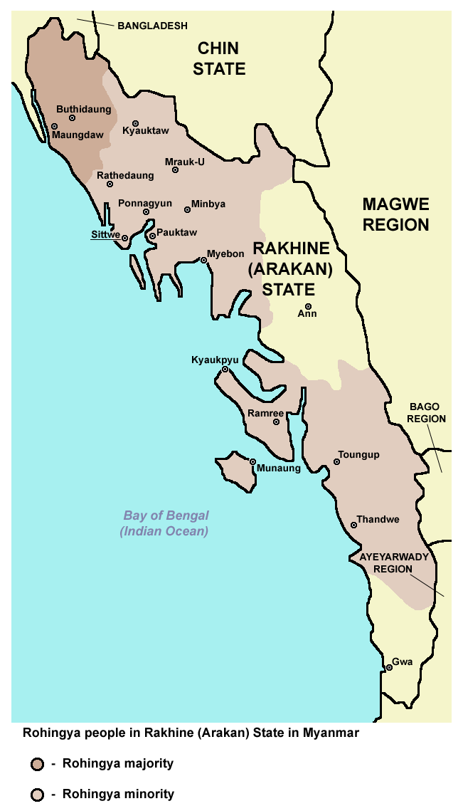 | 651 × 1,132 (61 KB) | smartcommons>WikiEditor2004 | Reverted to version as of 12:27, 4 July 2015 (UTC) - pointless change, not an improvement, please explain on talk page why image with no border would be better |
File usage
There are no pages that use this file.
