
File:Map of Israel, neighbours and occupied territories.svg

Original file (SVG file, nominally 559 × 721 pixels, file size: 688 KB)
Summary
| DescriptionMap of Israel, neighbours and occupied territories-en.svg |
Català: Mapa de l'Orient Mitjà que mostra Israel, Egipte, l'Aràbia Saudita, Jordània, Síria i el Líban, incloent-hi Gaza, els Alts del Golan i Cisjordània.
English: Map of the Middle East showing Israel, Egypt, Saudi Arabia, Jordan, Syria and Lebanon including Gaza, Golan Heights and West Bank.
العربية: خريطة دولة إسرائيل والأراضي الفلسطينية التي تشمل الضفة الغربية وقطاع غزة والجولان السوري المحتل. |
| Date | |
| Source | SVG extracted and edited from PDF |
| Author | un.org |
| Other versions |
Other related versions: []
|
| SVG development InfoField |


|
This SVG file contains embedded text that can be translated into your language, using any capable SVG editor, text editor or the SVG Translate tool. For more information see: About translating SVG files. |


|
This file is translated using SVG <switch> elements. All translations are stored in the same file! Learn more.
For most Wikipedia projects, you can embed the file normally (without a To translate the text into your language, you can use the SVG Translate tool. Alternatively, you can download the file to your computer, add your translations using whatever software you're familiar with, and re-upload it with the same name. You will find help in Graphics Lab if you're not sure how to do this. |
Licensing
| Public domainPublic domainfalsefalse |

|
This image is a map derived from a United Nations map.
Unless stated otherwise, UN maps are to be considered in the public domain. This applies worldwide. UN maps are, in principle, open source material and you can use them in your work or for making your own map. UN requests however that you delete the UN name, logo and reference number upon any modification to the map. Content of your map will be your responsibility. You can state in your publication, if you wish, something like: based on UN map … (map name, map number, revision number and date). See: Geospatial Information Section. And: Geospatial, location data for a better world. |
 |
| Public domainPublic domainfalsefalse |
|
|
I, the copyright holder of this work, release this work into the public domain. This applies worldwide. In some countries this may not be legally possible; if so: I grant anyone the right to use this work for any purpose, without any conditions, unless such conditions are required by law. |
Captions
File history
Click on a date/time to view the file as it appeared at that time.
| Date/Time | Thumbnail | Dimensions | User | Comment | |
|---|---|---|---|---|---|
| current | 00:30, 19 November 2025 | 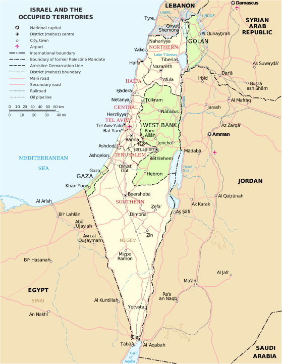 | 559 × 721 (688 KB) | smartcommons>Haziq Faruqi | File uploaded using svgtranslate tool (https://svgtranslate.toolforge.org/). Added translation for ms. |
File usage
There are no pages that use this file.
