.svg)
File:Map of Catura (Qatar) 1794 (cropped).jpg
Size of this preview: 220 × 172 pixels. Other resolution: 259 × 203 pixels.
Original file (259 × 203 pixels, file size: 20 KB, MIME type: image/jpeg)
Summary
| Description |
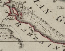
English: A map, “Arabia According to Its Modern Divisions”, made by Samuel Dunn in 1794 which shows the Arabian Peninsula, the Persian Gulf and Iran. |
| Date | |
| Source | Qatar Digital Library |
| Author | Samuel Dunn, Qatar National Library |
| Other versions |
_1794.jpg)

_1794_(cropped).jpg)
Licensing
This file is licensed under the Creative Commons Attribution-Share Alike 4.0 International license.
- You are free:
- to share – to copy, distribute and transmit the work
- to remix – to adapt the work
- Under the following conditions:
- attribution – You must give appropriate credit, provide a link to the license, and indicate if changes were made. You may do so in any reasonable manner, but not in any way that suggests the licensor endorses you or your use.
- share alike – If you remix, transform, or build upon the material, you must distribute your contributions under the same or compatible license as the original.
File history
Click on a date/time to view the file as it appeared at that time.
| Date/Time | Thumbnail | Dimensions | User | Comment | |
|---|---|---|---|---|---|
| current | 02:43, 12 January 2019 | | 259 × 203 (20 KB) | wikimediacommons>Elspamo4 | File:Map of Catura (Qatar) 1794.jpg cropped 9 % vertically using CropTool with precise mode. |
_1794.jpg)
File usage
The following page uses this file:
_1794_(cropped).jpg)