.svg)
File:Map of Battle of Cochin (1504) Pass of Cambalão.gif
Size of this preview: 191 × 329 pixels. Other resolutions: 139 × 240 pixels | 429 × 740 pixels.
Original file (429 × 740 pixels, file size: 57 KB, MIME type: image/gif)
_Pass_of_Cambal%C3%A3o.gif)
Summary
| Description |
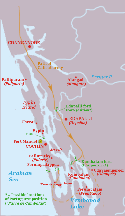
English: Map indicating some possible positions of the ' Pass of Cambalão', the position where the Portuguese force under Duarte Pacheco Pereira held against the Zamorin of Calicut during the Battle of Cochin in April, 1504. The map is highly conjectural, based roughly on the modern geography of Kochi and Vembanad lake, which has probably changed substantially since the 16th C. Green dots = possible locations of the Portuguese position, Straight line = most probable route of Calicut army; Dotted line = alternative longer route for army of Calicut. |
| Date | |
| Source | Own work |
| Author | Walrasiad |
Licensing
I, the copyright holder of this work, hereby publish it under the following license:
This file is licensed under the Creative Commons Attribution-Share Alike 3.0 Unported license.
- You are free:
- to share – to copy, distribute and transmit the work
- to remix – to adapt the work
- Under the following conditions:
- attribution – You must give appropriate credit, provide a link to the license, and indicate if changes were made. You may do so in any reasonable manner, but not in any way that suggests the licensor endorses you or your use.
- share alike – If you remix, transform, or build upon the material, you must distribute your contributions under the same or compatible license as the original.
File history
Click on a date/time to view the file as it appeared at that time.
| Date/Time | Thumbnail | Dimensions | User | Comment | |
|---|---|---|---|---|---|
| current | 16:43, 8 August 2010 | | 429 × 740 (57 KB) | wikimediacommons>Walrasiad | {{Information |Description={{en|1=Map indicating some possible positions of the ' Pass of Cambalão', the position where the Portuguese force under Duarte Pacheco Pereira held against the Zamorin of Calicut during the Battle of Cochin in April, 1504. |
File usage
The following page uses this file:
_Pass_of_Cambalão.gif)