.svg)
File:Map of Afghanistan during the Safavid and Moghul Empire.jpg

Size of this preview: 220 × 151 pixels. Other resolutions: 320 × 219 pixels | 500 × 343 pixels | 2,532 × 1,736 pixels.
Original file (2,532 × 1,736 pixels, file size: 1.16 MB, MIME type: image/jpeg)
Summary
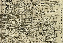
| Description | Map of Afghanistan during the Safavid and Mughal Empire, from the 16th century to 1747 when the current nation-state was created. Extracted from Bowen's A new & accurate map of Persia, with the adjacent countries. | ||
| Date | |||
| Source |
From: Bowen's A complete system of geography. London : Printed for W. Innys, R. Ware [etc.], 1747. Library of Congress Geography and Map Division, Call number G7620 1747 .B6
|
||
| Author | Bowen, Emanuel, d. 1767. | ||
| Other versions |
|


Licensing
|
This work is in the public domain in its country of origin and other countries and areas where the copyright term is the author's life plus 100 years or fewer. | |
| This file has been identified as being free of known restrictions under copyright law, including all related and neighboring rights. | |
File history
Click on a date/time to view the file as it appeared at that time.
| Date/Time | Thumbnail | Dimensions | User | Comment | |
|---|---|---|---|---|---|
| current | 08:20, 2 March 2011 | | 2,532 × 1,736 (1.16 MB) | wikimediacommons>Officer | {{Information |Description= |Source= |Date= |Author= |Permission= |other_versions= }} |
File usage
The following 3 pages use this file: