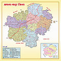
File:Latur District political map.jpg

Size of this preview: 220 × 220 pixels. Other resolutions: 240 × 240 pixels | 375 × 375 pixels | 1,524 × 1,524 pixels.
Original file (1,524 × 1,524 pixels, file size: 1.36 MB, MIME type: image/jpeg)
File history
Click on a date/time to view the file as it appeared at that time.
| Date/Time | Thumbnail | Dimensions | User | Comment | |
|---|---|---|---|---|---|
| current | 17:57, 16 July 2012 |  | 1,524 × 1,524 (1.36 MB) | wikimediacommons>Woodoome | {{subst:Upload marker added by en.wp UW}} {{Information |Description = {{en|Latur District political map}} |Source = http://zplatur.gov.in/htmldocs/leftframe/LaturMap.html |Author = zplatur |Permission = http://zplatur.gov.in/htmldocs/leftframe/LaturMa... |
File usage
The following page uses this file: