.svg)
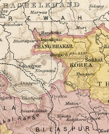
File:KoreaKart.jpg
Size of this preview: 220 × 270 pixels. Other resolutions: 195 × 240 pixels | 372 × 457 pixels.
Original file (372 × 457 pixels, file size: 166 KB, MIME type: image/jpeg)
Summary
| Description | Mapa del Principat de Korea (Índia) | ||
| Date | |||
| Source | http://de.wikipedia.org/wiki/Datei:KoreaKart.jpg | ||
| Author | Govern britànic | ||
| Permission (Reusing this file) |
|

Licensing
This file is licensed under the Creative Commons Attribution 2.0 Generic license.
- You are free:
- to share – to copy, distribute and transmit the work
- to remix – to adapt the work
- Under the following conditions:
- attribution – You must give appropriate credit, provide a link to the license, and indicate if changes were made. You may do so in any reasonable manner, but not in any way that suggests the licensor endorses you or your use.
File history
Click on a date/time to view the file as it appeared at that time.
| Date/Time | Thumbnail | Dimensions | User | Comment | |
|---|---|---|---|---|---|
| current | 08:01, 7 February 2011 | | 372 × 457 (166 KB) | wikimediacommons>MALLUS | {{Information |Description= Mapa del Principat de Korea (Índia) |Source= http://de.wikipedia.org/wiki/Datei:KoreaKart.jpg |Date= 1931 |Author= Govern britànic |Permission= {{GFDL}} |other_versions= NO }} Category:History of India by state |
File usage
The following 2 pages use this file: