.svg)
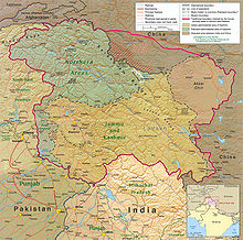
File:Kashmir region 2004.jpg

Size of this preview: 220 × 218 pixels. Other resolutions: 242 × 240 pixels | 378 × 375 pixels | 1,579 × 1,567 pixels.
Original file (1,579 × 1,567 pixels, file size: 1.71 MB, MIME type: image/jpeg)
| Description |
English: Kashmir Region 2004 |
|||
| Date | ||||
| Source | http://www.lib.utexas.edu/maps/middle_east_and_asia/kashmir_region_2004.jpg | |||
| Author | CIA | |||
| Permission (Reusing this file) |
|
|||
| Other versions |
 .jpg)
|


File history
Click on a date/time to view the file as it appeared at that time.
| Date/Time | Thumbnail | Dimensions | User | Comment | |
|---|---|---|---|---|---|
| current | 03:15, 7 June 2010 | | 1,579 × 1,567 (1.71 MB) | wikimediacommons>Ras67 | slightly rotated and cropped |
File usage
The following 10 pages use this file:
- 2014–2015 India–Pakistan border skirmishes
- 2016 Indian Line of Control strike
- Article 370 of the Constitution of India
- Asghar Khan
- Indo-Pakistani War of 1965
- Jammu and Kashmir (state)
- Khan Mughal
- United Nations Security Council Resolution 47
- United Nations Security Council Resolution 80
- War on terror